
After I shared photos of a psuedo-cycle track in Tigard, and when I visited an actual two-way cycle track in Eugene, some of you contacted me to share your experiences with a cycle track in Beaverton, about two miles south of Tualatin Valley Highway.
I went to check it out for myself and it was nice to have dedicated space for me and my bike. Unfortunately the cycle track is more of a proof-of-concept than it is a valuable piece of a transportation network.
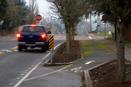
At barely two tenths of a mile long the track is best suited for local traffic and doesn’t do much to connect other bicycle-friendly routes.
The cycle tracks runs next to Sexton Mountain Elementary School, along SW 155th between Sexton Mountain Drive and Rigert Road (you can see it in this satellite view of the area).
First, let me share what works well on this stretch of road.
Bicycles travel on asphalt raised up to the level of the sidewalk for most of the length of the cycle track. Planters and trees provide a barrier to motor vehicle traffic in those sections as well.
The bicycle lane drops back down to the level of the motor vehicle lane at intersections, sharing a space with motor vehicles at stop signs.
Initially I was expecting right-turning cars to pull over and block bicycle traffic but in my time riding in the area most cars kept to their side.
Textured pavement in the intersections, combined with planters and trees separating most of the bike lane, seem to be enough of a reminder that people in cars should be watching out for other modes of transportation.

The cycle track passes through three- and four-way stops along SW 155th, demonstrating that this style of cycle track can be adapted to different types of intersections.

There are also many elements of the cycle track that could use improvement.
Speed bumps have been installed in the motor vehicle lane in an attempt to limit travel to the legal, posted speed limit. The bumps aren’t particularly large though, and cars seemed to have no trouble passing over them without slowing down.
One person in a truck passed through while I was taking pictures, traveling at what seemed to be well over the posted speed limit. They didn’t need to slow down over the bumps at all. Only the four-way stop caused them to briefly reduce their speed.
The south end of the cycle track is also uninviting to bicycle traffic.
Coming from the south you have to share the road with motor vehicles traveling quickly downhill, without the aid of a bike lane, while watching for people opening the doors of parked cars.
Leaving the cycle track and heading back south in the opposite direction, you’re dropped off the track and onto a road with nearly no shoulder and no signs warning other traffic of merging bicycles.

This cycle track is a great addition to the neighborhood but it doesn’t provide much value (outside of improving access to the elementary schoo)l. It provides safer access to the school for kids and parents, and could be helpful if you’re already planning to ride on SW 155th, but it’s not worth going out of your way to ride along the track.
Without safe, convenient connections to the ends of the cycle track it will likely continue to only benefit short, local trips. However, this section of SW 155th can serve as a proof of concept showing that we can find plenty of room on the road for all of us, even in the suburbs.
Do you ride your bike along this stretch of road? How did you use it to travel around Washington County?
UPDATE: Bill LaMarche, Public Information Manager for the City of Beaverton, emailed me with some additional details about the track’s construction and some recent work done to smooth out the asphalt:
The cycle track was constructed with the SW 155th Avenue Improvements in 1996.
The project was designed by the City of Beaverton to help walkers and cyclists who use 155th in that area. The sidewalk was not originally extra wide but improved later.
The City’s Public Works Street Crew ground down the raised asphalt about a month ago due to tree roots.
You can see a photo of the asphalt smoothing LaMarche refers to here.
— Read more Washington County bike news here. Contact Will Vanlue, will [at] bikeportland.org with tips and feedback.


Thanks for reading.
BikePortland has served this community with independent community journalism since 2005. We rely on subscriptions from readers like you to survive. Your financial support is vital in keeping this valuable resource alive and well.
Please subscribe today to strengthen and expand our work.
also Note that Green moss can get slick becareful riding this time of year 🙂
“Two-tenths of a mile long.” That’s hilarious!
What’s the history of this two tenths of a mile cycle track on 155th in Beaverton, and how did it come to be?
I don’t know personally, but I have a message out to the city to get more information. As soon as I hear back from them I’ll be sure to share.
I the mean time, anyone should feel free to chime in if they know…
Hope you get some good details on that.
Have a feeling that this cycle track may have been part of concessions made by developers towards approval of permits to build. Design and construction from such a source could account for the tracks’ short length.
Traffic calming, and/or a possible answer to local parents concern over their kids being able to safely walk and bike to school. People with the Sexton Mtn Neighborhood Association might know the story.
http://www.beavertonoregon.gov/index.aspx?nid=709
Second picture down where main lane and cycle path share textured pavement, because there’s no line down indicating a bike specific lane, looks bad for a right hook.
I’m thinking it’s a “THINK OF THE CHILDREN” factor, but nobody lets their kids take the bus to school in this neighborhood of 1%ers, much less walk or ride: “Too dangerous.”
if by ‘cycle track’ you mean ‘crappy side path’, I’m with you.
The only crappy part is that it doesn’t go any further.
The quality of the pavement and the separation from motor vehicles is on par with cycle tracks I’ve ridden on in Copenhagen and Amsterdam.
how about the intersection treatments?
Quality is the same, but the configuration is way different. I don’t think I saw a single stop sign in either city, and stop lights were few and far between.
But the roundabout/yield vs stop sign debate is one for another time. 🙂
You don’t get right-hooked in roundabouts the same way you do at stop sign or signal controlled intersections.
This isn’t a debate for another time, it is the single most significant safety hazard and IMO the fatal flaw of cycle track designs as they are either being implemented or proposed in the Portland metro area.
Sure it is – yield vs. stop on roundabouts has nothing to do with Cycle Tracks in Portland Metro at this time, unless you’re arguing that we’ve already implemented them here – which to my knowledge, we haven’t. If you want to make it topical to this thread, then we could speculate on whether a cycle track would work at Coe Circle, for example – or in Ladd’s, both of which are roundabouts with stop signs.
We don’t *have* to bring in every debate from bikeportland for the last 4 years into every thread – we can actually stay relevant and on-topic if we so choose.
what’s relevant here is that Jonathan and his staff continually beat the drums for separated paths, but don’t seem to understand the unique hazards and fatal flaws of superimposing such paths on our existing roadway grid.
Roundabouts and cycletracks’ function is different. They aren’t interchangeable in terms of their purpose.
Beyond this, neither cycle tracks or roundabouts are panaceas for complexities associated with common use of streets and roads by different modes of travel. Both cycle track and roundabout are substantially limited in the range of road situations they can be used, whereas street grids in general with 90 degree angles work in a wide range of road situations.
Portland bikeforums member q’Tzal dug up a bunch of info on this topic, which some of us discussed across the first two and a half pages of this thread:
http://bikeportland.org/forum/showthread.php?t=4086
Simply designed and laid out streets should be the best, commonly used by all modes of travel if that functionality wasn’t severely compromised by allowing motor vehicles to travel at speeds that are incompatible with slower modes of travel.
They suck. The double white lines at the approaches give you no lane change option, which makes it questionable whether a left from the track or right from the main roadway is even legal.
Exactly.Note that you can’t make a vehicular left turn since you can’t merge into the travel lane in advance of the intersection. Just another zoo cage for the funny cyclists.
The left turns are the flaw on this (and many) cycle tracks.
There are no left turn queue boxes (the conventional solution for left turns from a cycle track) and there is not enough room to merge into the adjacent lane for a vehicular left.
The intersections are all 4-way stops anyway, which creates a confusing situation when a left turning bicyclist is sitting to the right of a through motorist, and doesn’t have time to merge over. That said, traffic on this street appears to be low enough that the two intersections could probably be handled without much trouble.
One solution would be to adjust the stop signs to control only the side streets, and then provide left turn boxes for the bicyclists. I know it’s not the preferred solution for the vehicular crowd, but I can’t see the local 9 year olds on their way to school making a vehicular left turn.
Left turn boxes would be a good addition if they were installed properly.
Another option with the current configuration is the “Copenhagen left“, but that’s not something a lot of people are used to performing.
As mentioned, it seems like the traffic treatments here go with the school. Will, did it seem like the beginning and end coincided with property lines like that? It just reminds me of so much of SW metro area, where newer development includes sidewalks, et cetera, whether by modern code or good faith, but the older, adjacent areas are not similarly accessorized. So you see all these short sidewalks by newer houses or multi-family developments, and they either veer out to the asphalt, or end abruptly at a type three barricade at the end of the newer development. Seems like the same phenomenon, but the ones I’ve seen so far are just ped treatments.
There are lots of neighborhoods where sidewalks were not in the original plan. Building to a higher standard, especially now that these areas are more extensively and densely developed makes sense to me. I have no idea, though, how you get the rest of the network built. Very expensive. My neighborhood has a couple examples of this, while most is sidewalk-less. Little sidewalks to nowhere. On the narrower interior streets it seems really silly. On a collector/thoroughfare it’s probably good to go whole hog while the money’s there and you’re building anyway, even if there’s no plan to connect in the near future.
“…I have no idea, though, how you get the rest of the network built. Very expensive. …” Machu Picchu
Yup…expensive. That’s probably why the cycle track as shown in the bottom picture, just ends. To continue the cycle track on over the ditch that can be seen in the distance in that picture, what might the city or other jurisdiction have to do? Develop a plan, a budget and funding, negotiate with property owners, secure easements, design and build it.
If we eventually get the details on this particular cycle track’s origin, the info may reveal that developers had to pay to build it. For additions to the cycle track though, taxpayers may have to pay for construction, which is where the powers of communication and persuasion are essential.
Most of those subdivisions were built prior to the land being incorporated into a city – they were being built in forest or farmland, part of the county only. As a result of when they were built, there were no zoning or development requirements to have developers add things like sidewalks. That is a relatively recent development in Oregon’s history.
Remember, this state used to be very lassez-faire about these types of things. Unfortunately, they also have left a terrible legacy on our built environment that does need to be addressed, but nobody today wants to pay for it.
“Most of those subdivisions were…” was carless
All of what you wrote in your comment after those opening words, is true. Decades ago, that approach to planning and travel infrastructure design was fine with the low population existing then.
The challenge today is in revealing to people the need for revolutionary change in the way they get around their neighborhood and their town, and the somewhat drastic measures that might be needed to accomplish that change.
“It provides safer access to the school for kids and parents,” – WV
It provides safer access to the school, period. Sorry to nit-pick, I just smell a stereotype. We think safety especially in a school zone because of children, right? Just wanted to emphasize that if you’re going to include parents, you ought to include everyone. Kids and parents are the “customers” of the school, but many others utilize the “access” as well.
The third picture down is an example that I have an issue with(the junction not the picture). There is absolutely no need to have bicycles stopping at the 3-way intersection. The bikes have their own lane and do not interfere with car traffic, while car traffic do need to stop to allow for entering car traffic and as a semi-traffic calming measure, bikes can do their own thing.
What could be done is a small bollard treatment crossing the intersection that continues the bike lane and allows for bikes coming from the left side to enter the track with little problem, or for folks needing to turn right to position themselves so they can do so.
This is a case where the whole same roads same rules bit fails, and an intersection such as this needs to be treated differently for folks on bike than on cars. Normal 4 way intersection all stop fine, but bikes going straight should not have to in a three-way intersection such as this, but that preference is also typically European with bypasses for certain movements (such as right turn) at intersections and roundabouts etc while car traffic has a yield or a traffic light.
Here is a somewhat extreme example from the Assen in the Netherlands
http://maps.google.com/maps?q=assen+netherlands&ll=53.028278,6.571576&spn=0.001208,0.002411&hnear=Assen,+Drenthe,+The+Netherlands&gl=us&t=k&z=19&vpsrc=6&layer=c&cbll=53.028341,6.571578&panoid=UQ1gw-Zl6CQGpsO6MpaFBA&cbp=12,187.56,,0,-1.8
Two-way cycle track bypasses the intersection entirely (of course bikes would not turn here, they would turn later on at the next intersection, so no need to have access.
-John
This is a great point, and I wholeheartedly agree. That streetview of the Netherlands is amazingly well designed!
The cycle path is right in front of Sexton Mountain Elementary School. I grew up there. The road has changed a lot and gotten a lot of treatments. They put in some cobblestone in front of the school about 15 years ago. As new housing developments popped up farther down the road towards Weir the sidewalk was expanded and included a mulch path for runners. I think the city decided that the mulch path wasn’t as valuable as a sweet cycle path. A two-tenths of a mile cycle path isn’t much, but for Beaverton it’s an innovative step in the right direction. I can see this getting expanded and connecting to TV highway and through the Murrayhill neighborhood. I find this very exciting. Boom baby. This will go a long way to encourage cycling and walking to the school which doesn’t have bus routes within the first mile radius. My parents’ neighbor drives her kids to the school because she feels it is unsafe for them to bike or walk. Maybe this will change her mind.
I take it back. This is old and doesn’t connect with the still existent mulch path. Shucks.
Any idea why we speed bumps get installed that don’t slow down cars? I see something similar on SW Spring Garden St. The speed bumps are not very effective.
Because bumps don’t slow cars down. It’s a flaw in the whole concept that a bump will slow cars down in the first place, especially in Washington County where the roads are generally poor enough to make a speed bump indistinguishable from the normal highway.
Speed bumps or humps do a reasonable job to slow cars down. It’s just that the majority of vehicles are now high ground clearance, multi passenger light trucks without beds, ie SUV/Crossover.
Chevy Malibu’s a truck?
This one reminds me of another little-known cycle track to nowhere, on north Eugene’s Ayers Road.
I’ve ride this stretch sometimes. It’s an entertaining momentary distraction from the normal riding routine on Beaverton streets. This section of road is part of a green streets pilot project that not only has the short cycle-track but also a bunch of changes to reduce drainage run-off (swales & an experimental stretch of pervious sidewalk).
As mentioned this little cycle path really only serves to give kids in the neighborhood down the street safe access to the school. Not a bad thing, just not really of noticable value to anyone beyond that.
From a biking standpoint 155th is probably the most easterly N-S path that lets you avoid humping over Cooper mountain. Traffic is reasonably light & generally well mannered (Probably not even 50% of the cars speed or roll thru the stop signs -that’s pretty good, right??). It would be nice to have a wider shoulder on that southern part, but even w/o it is often more pleasant than the parallel, bike-laned & much busier Murray blvd a few blocks over.
“…This section of road is part of a green streets pilot project that not only has the short cycle-track but also a bunch of changes to reduce drainage run-off (swales & an experimental stretch of pervious sidewalk). …” TV commuter
Thanks TV commuter. Some kind of pilot project with ‘state and federal funding sources’ could have been another way this short section of cycle track came to be. It would be great if more people with knowledge of the cycle track’s history could post comments with the details.
Tim: http://bikeportland.org/2011/12/29/beavertons-cycle-track-looks-great-but-doesnt-connect-the-dots-64374#comment-2392015
Yours is a solid critique of the cycle track. I don’t regularly ride it, but seem to recall having done so maybe a year ago. I was wanting to ride rather quickly, so it wasn’t worth my time. For people that want to amble along slowly though…5-10mph…it could be just the ticket. Assuming there were places nearby to buy a few groceries and so on, a track like this could offer an option to some people that would be interested in a little exercise rather than a sit.
I encountered that cycletrack by chance about a year and a half ago and mapped it, thinking, “Wow, that was weird” when I cleared it. It hit me as especially strange since it doesn’t even connect the school it’s in front of…really should be far longer.
Interesting that so many comments are from people who never ride this section of road. I ride it nearly every day. Because of this expereince, I am not a fan of “cycle Tracks”. I seldom ride in the road because to ride in the road, you must take the lane and too many drivers feel you should be on the bike path or die.
Problems with the cycle track include: poor pavement and moss, pedestrains who see it as a wide sidewalk, school children and their parents running out in front of you, car doors and even parked cars. Since you can’t merge into the lane at the ends of the block left turns are tricky and right hooks are harder to avoid.
Instead of inforcing laws intended to protect cyclists, the cycle path segragates the cyclists so they don’t bother the speeding cars.
While segregation may make some feel safer, enforcement of traffic laws and discouraging parents from driving their children to school would actually make it safer.
Will, do you know about the Cycle Track on SW Farmington?
http://bikeportland.org/2011/02/23/beyond-beaverton-by-bike-48461
That thing’s just the worst thing ever. Going westbound is awful since you have eastbound bikes on one side and eastbound motorists on the other, really feels like you’re swimming upstream. Then when it ends at Menlo, the MUP that used to dump you onto a cycletrack on 2nd and launch you across the BHS campus is now a drainage swale. Beaverton never ceases to amaze me in how it finds new and creative ways to EPIC FAIL.
The Farmington Rd bike lane…the south side has a curb dividing it from the main lane, so I suppose it could be called a cycle track…isn’t great, but looking at a map, there doesn’t seem to be streets close to Farmington that could serve as an alternative, parallel route.
Many residences are right along Farmington. Widening Farmington to provide for a wider bike lane would require easements from those property owners.
Ideally, the land next to Farmington would be substantially redeveloped, providing residences with side streets by which they could access Farmington, thus eliminating many of the driveways that currently cross the bike path to access Farmington. As if such a grand scheme would have even the slightest chance of happening.
Yeah, I was riding along it last week to meet a friend for coffee.
It’s a good idea, but I’d really like to see the curb installed on both sides of the road. Some markings at crossings with driveways would be nice too.
Actually, I’d really like to see the rest of this 80’s relic removed and replaced with bike lanes as has already been done at the east end. This is a bad idea; the many street crossings guarantee that either a motorist will block the path while trying to enter Farmington from the side street, or they will expect you to stop and if you don’t bad news for both of you. And that is assuming you aren’t riding against traffic; in that case you better stop at EVERY cross street because no one will be looking for you coming the wrong direction.
And the advantage of what you propose would be?
Motorists on cross streets entering Farmington would still need to be crossing the bike lane. All the residents living along Farmington would still have to be crossing the bike lanes. Businesses too.
The Farmington cycle track is barely a cycle track. Only a simple curb separates it from the main lanes of traffic. Making it a bike lane by removing the curb would give people riding bikes the option of moving more freely into the main lane of traffic to distance themselves from people coming out of driveways and cross streets, except that Farmington is a really bad road upon which to have to take the main lane.
Farmington between lets say….185th and Beaverton, is so intensely busy and fast with motor vehicle traffic though, that the curbed bike lane has seemed to me to be kind of a blessing even if travel along it is awkward.
I have noticed a lot of newer bike lanes that just end. It seems like bike lanes have become a requirment when roads are updated. Look at the 185th widening by Kinnamen. So, I guess at least lanes are being added a little at a time. Better than other parts of the country that have no bike lanes.
Still more general education is needed. I ride along 170th everyday. Residents us the bike lanes to keep their trash cans safe on pick up day. Not good!! I actually hit one this morning. A full trash can doesn’t freely move out of the way. It’s only my fault for hitting the trash can, but swerving around them into traffic creates a dangerous situation as well.
I push ’em over with my bike or car if they leave ’em in the street.
As someone who live in the ‘hood, I concur that the main problem with this is its abruptness. SW Hart Road is an excellent street for cyclists, but SW 155th north of Hart and south of Sexton Mountain is not; both stretches are narrow with little-to-no shoulders or other such improvements; the only option for bikes is to take the lane. 155th between Hart and SW Davies also features some blind curves which make cycling especially treacherous; fortunately ample speed bumps slow the car traffic down somewhat. This stretch is particularly problematic, as it is adjacent to a major gap in the powerline trail (which lies about 5 blocks to the west); between Hart and Davies the powerline right-of-way crosses over Mt. Williams, and is presently impassable to bikes (and to pedestrians as well, unless you like a rather steep climb).