series of stencils on the pavement to help
riders find their way onto and over
the I-5 bridge.
(Photo: Beck)
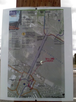
A laminated map and stencil markings have mysteriously appeared on the shared-use paths leading up to the I-5 bridge. We haven’t figured out who’s behind them, but several people say the signs are a big help.
To ride a bike over the I-5 bridge from Portland to Vancouver is an exercise in frustration. Before even getting on the deck of the bridge (which is narrow and a bit frightening to many riders), people on bikes are forced through a series of awkward crossings and sidewalk riding. And that’s only if you can figure out where you’re supposed to ride to begin with.
The City of Vancouver has tried to improve signage (but was shot down by ODOT) and Metro’s solution was to put out a how-to video.
Now, someone has taken the matter into their own hands…
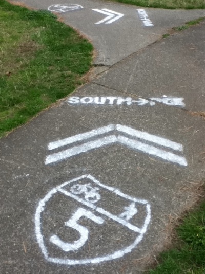
A reader named Beck sent in photos of the signage a few weeks ago. He says there are two laminated maps (both near the bridge on the Oregon side) along with “probably six to eight stencils indicating routes on Jantzen Beach and on the Vancouver side leading to the bridge.”
Vancouver resident (and former City of Vancouver Transportation Planning employee) Todd Boulanger says, “They are the 3rd generation of this grass roots effort – and much more refined than before.”
I’m glad someone stepped up and did this, yet it’s too bad that an official and more permanent solution has not yet come to pass.
So… the question remains: Whodunnit?


Thanks for reading.
BikePortland has served this community with independent community journalism since 2005. We rely on subscriptions from readers like you to survive. Your financial support is vital in keeping this valuable resource alive and well.
Please subscribe today to strengthen and expand our work.
They’ve been there for at least a week, and they made my last ride to The Couve bearable. By now I know how to get there by deduction (having made every possible mistake), but the sometimes-confusing signs were still a help. Extending that information as far as Delta Park would help even more.
I’m glad I sent the same pictures about three weeks ago and you’re just now posting this. All I got was a “cool Beck. thanks.” Must be a slow news day for you.
thanks for the reminder Beck. I tried to find your email but couldn’t. I’m updating the story now with your photos and info.
cheers,
Reminds me of the fake I-5 freeway sign that Caltrans decided to keep.
http://www.good.is/post/the-fake-freeway-sign-that-became-a-real-public-service/
Hope ODOT recognizes the value.
The difference between that stunt, and this, and probably a factor in play, is that the California artist did his homework and used materials that met the DOT standards for reflectivity, size, color, durability, etc. His fake was so convincing, it took CalTrans months before some random highway engineer that took the route regularly noticed the sign wasn’t in the state inventory!
While I think the markings are an improvement, I’m thinking pulling the same trick with the same materials and specs ODOT would use for bicycle facilities and some Interstate 5 trailblazers with NORTH/SOUTH and BIKE plates on signposts might fly under the radar longer mostly because ODOT crews in the area wouldn’t be as likely to notice that they don’t belong there (since they would look like they do, and most road crews don’t have the inclination to check the sign inventory unless they have to).
In spite of the stickler for standard signs that I am… I must admit I’ve been tempted to do this on more than a few occasions to some streets in various Chicagoland suburbs.
I’ve read through the MUTCD a few times and while standardized signage is one of the most important systemic improvements to road safety unfortunately it can be rather stifling when needed information is not already listed on a specifically designed sign.
Ding ding ding!
I don’t see how this is stifling, since standard Interstate trailblazers with NORTH/SOUTH and BIKE supplementary plates could be used in this application, along with standard green wayfinding signage (or, less ideally, bicycle wayfinding signs; though for whatever reason, the text on these is a bit too small to be read from a reasonable distance).
Well, the MUTCD is very VERY specific about every aspect of signage:
Table 2A-3. Minimum Maintained Retroreflectivity Levels
Table 2A-4. Use of Sign Shapes
Table 2A-5. Common Uses of Sign Colors
Figure 2A-1. Examples of Enhanced Conspicuity for Signs
Any sign not in compliance is illegal and it is the responsiblility of the responsible DOT to remove it.
If you want a sign to be allowed there is a <sarcasm>”simple”</sarcasm> process:
Figure 1A-1. Process for Requesting and Conducting Experimentations for New Traffic Control Devices
Figure 1A-2. Process for Incorporating New Traffic Control Devices into the MUTCD
For example:
In my little diversion with “Hazardous Obstacles on the Sunset MUP” we saw a situation that needed improvement but no existing sign or marking would bring the hazard area in to a similar level of safety as is applied to automotive roads. While the surface markings that have been recently applied are an improvement if that was an automotive road “Type 3 Object markers” would have been required. Indeed the last entry of Table 9B-1. Bicycle Facility Sign and Plaque Minimum Sizes calls for these Type 3 Object markers unfortunately there are no approved places to put them there. Figure 9B-1. Sign Placement on Shared-Use Paths shows that the edge of any physical sign must be 2 feet outside the edge of a MUP surface. Unfortunately the Sunset MUP, and the I-5 MUP and nearly every other shoehorned MUP, has no room to place needed signage legally so the problem is simply shelved as impossible to solve.
MUPs are usually funded as recreational or parks improvements with the unspoken knowledge that usage will include utilitarian transportation needs. In the legal limbo that most MUPs exist in it is difficult to get a jurisdiction or department to even acknowledge their responsibility let alone any request as something that is needed.
At least on the Sunset Cycleway, signage could be pole-mounted overhead from either the adjacent fenceposts or the sound wall (as is done on the I 84 Cycleway and parts of the I 205 cycleway). I haven’t been through the I 5 one recently, but at junctions, there’s enough horizontal clearance to make signage fit without encroaching pretty much everywhere there’s not a spot you couldn’t run a post horizontally from an adjacent structure.
Though ODOT plays fast and loose with the MUTCD on the I 5 crossing as it is…ever notice how the bicycle lanes get a chain link gate and no proper signal?
AC I’m not crying about it. I guess I was a little more interested in it since I bike that every day. I would imagine someone going that was for the first time wouldn’t have a clue where to go since there was basically no signage anywhere. Whoever did this rocks in my book.
The first time I biked from SE Portland to Vancouver googlemaps had just started testing their bike option. I copied their directions and did o.k.
But this analog approach is excellent.
This makes me happy. Someone out there should feel VERY useful. I haven’t been that way in a while, but I got used to improvising through the years.
I’ve been known to use paint, but I can’t claim this as my work.
Oh, and for those who might be thinking of something like this, marking paint is designed to fade over time. Rust-oleum Striping paint doesn’t (but don’t bet money on getting the full length of striping that Home Depot claims you can get).
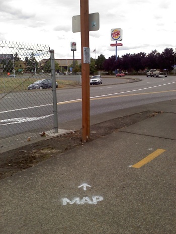
Now if they could only fix the crossing between the gas station and the Safeway parking lot; I can’t begin to count the number of times I’ve almost been clipped by drivers making that (somewhat blind) right turn from the I-5 North offramp (incidentally, just beyond the picture of the “Map” stencil).
I know a lot of drivers take that turn much too fast
Ideally, the whole Hayden Island interchange for bicycles would be re-engineered so the two-way cycleway joins south of the motorist interchange, instead of in the middle of the motorist interchange, and separate from local pedestrian facilities, instead of tucking cyclists out of obvious view of motorists, particularly in the southbound direction where you’re going counter to adjacent motor traffic.
Got a drawing? I’d like to compare and contrast your idea versus what I came up with.
I thought up something of a redesign a while back for the stretch from Delta Park through Hayden Island but lost my analog sketches. As “The Plague” said “Ugh. Hard copy.”
I agree – this is one of the most dangerous crossings on the route – [though it used to be worse before the island]. The installation of the high chainlink fencing and a large traffic sign blocks the advance warning sign for drivers that they are approaching a crosswalk. Very poor sight lines that are also not aided by the higher speeds that the sweeping highway corner radii facilitates.
There are several additional modifications that could be made to make this ODOT facility safer for vulnerable road users.
Thanks to the wayfinding super-hero!
that’s the City of Vancouver’s official map for crossing the bridge… you can get one here: http://www.cityofvancouver.us/upload/contents/738/InterstateBridgeMap.pdf
stencils don’t look crisp enough to be a metal template so I’m guessing poster board… so probably not a rogue city employee… I’m guessing a few friends got together and did it… good job on those…
Well, the dead giveaway it’s a rogue job is wayfinding pavement markings for routes just include the route shields, no arrows, unless it’s a turn-only lane. Some official examples appear on the approach on Tulsa City Route LL southbound approacing Interstate 244/US 75/US 412/OK 51.
Oops, I misidentified the location…it’s actually in the Inner Dispersal Loop on I 244 West, approaching the interchange with I 444/OK 51/US 75, with pavement markings also indicating how to loop back to US 412.
Great public service, by a member of the public. They should include some sort of reminder about the mandatory helmet law in Vancouver. Might save somebody a ticket.
And that you should keep your clothes on. They get kinda pissy when you ride nekkid there.
I saw and loved it a week ago. Almost sent it in. I wish it was a tad sharper but still, well-done!
Any other super heros out there wish to add a spary coat of clear over it – so it is protected longer?
Nice work, rogue stenciler.
ODOT also had plans to install signs along the Delta Park/Hayden Island mazes. Guess that hasn’t happened.
Ted Buehler
It was Vancouver, and they were Doing It Wrong, which is why it didn’t happen.
Nice! And much needed. The last time my friend and I tried to ride up to Washington on the I-5, we got turned around and ended up in Jantzen Beach.
It wasn’t you, Ted? That was my bet!
I hope whatever government agency leaves them there. That area is really confusing!
Whoever defaced this public property should be prosecuted to the full extent of the law.
Generally speaking, people don’t get prosecuted for something that’s a net win, especially when malice isn’t a forethought.
Whoever improved this public property should be commended to the full extent of the law.
Hopefully, they’re guiding people to the correct sides of the bridge on the state line side of Hayden Island, since it’s a divided MUP there. I’m glad to see the markings. After the official signage was stolen years ago and not replaced, about the only way I could find my way across it was with a bar-mounted Garmin, after I mapped it on OpenStreetMap. BTW, TriMet’s new trip planner will get it right, too, in both directions.
Also, Vancouver got shot down because they were inventing signage instead of suggesting MUTCD-compliant pavement markings and signs people would actually be familiar with. I like the Interstate shield used for wayfinding; I wish that ODOT would post I 5/I 205 route shields on the Interstate crossing officially and on the I 205 corridor trail to obviate it’s status and help cyclists arriving in town via freeway in Vancouver or Oregon City how to get through.
…there was the issue of bidirectional vs. one-way that can up.
Yes they direct northbound traffic to the east sidewalk. Unfortunately I still pass salmon.
Thank You anonymous map poster & stenciler! This action was much needed (and made permanent).
A quick scan of the MUTCD didn’t turn up any guidelines for sign material composition other than a reference buried in 2A.08 Maintaining Minimum Retroreflectivity about sign replacement interval needing to be matched to the retroreflectivity degradation.
With metal prices the way they are perhaps signs should be made from the ugliest of the low grade plastic recycling waste combined with UV stabilizers and reinforced with impregnated fiberglass or waste kevlar jacketing from fiber optic data installation.
Slap a smooth surface on the viewing side for the image and deploy.
I doubt making the signs out of the same stuff they make temporary rollup signs would stand the test of time given the conditions at that location.
Part of the problem with the ODOT wayfinding signs along this corridor is that they always are made of wood (for some reason unknown – perhaps there is a large warehouse of ‘vancouver this way’ signs in the Dalles, etc.) – wood burns so its been likley used for hobo heating.
The map on the west side of the I-5 underpass on Hayden Island has been ripped off the post it was attached to. I think the one on the north end of the southern bridge span is still there.
The nice laminated maps needed heavy duty staples too.
I recommend a 2012 Alice B Toeclips award ‘in absentia’ for these stencil super heros (versions 1, 2, 3).
All in favor email: info@bta4bikes.org
As a voncouver commuter, I love the signage. Epic job. Robin hood!