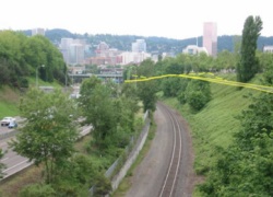
lines are proposed trail alignments
from a 2004 study.
(Photo: Portland State University)
Last week I directed your attention to the Sullivan’s Gulch project. I wanted more people to be aware of a meeting held last night by the Portland Parks Board which included the project on its agenda.
The Sullivan’s Gulch project (calling it a “trail” is a misnomer), which would connect East Portland to the Willamette River along I-84, is exactly the kind of investment we need to make if we want to live up to our green transportation rhetoric and meet our lofty carbon emission and bike usage goals.
Reader Carl Alviani went to the meeting last night and I asked him to share what he heard. Read Carl’s report on the meeting below (emphasis mine):
As it turns out, the Sullivan’s Gulch project barely got discussed last night. It was on the agenda, but the liaison reported that they’re still working with ODOT in Salem to get the advisory committee in place, and there won’t be any substantial meetings until that happens. The majority of the meeting was taken up by a Powerpoint on the 2020 vision for parks in Portland, and while bike greenways and corridors showed up several times, your concerns about “trail” implying a view of bike infrastructure as primarily recreational seems well founded. I know this was a Parks & Recreation meeting, but it’s still kind of disheartening to hear bikeways and playgrounds mentioned in the same breath.
That said, I did get to speak for a few moments with Sarah Coates Huggins, the project manager for PP&R, and she conveyed a pretty strong understanding that this is a functional project, not just recreational. I’m really curious to see what the PBOT meetings look like — my hunch is the more traffic-like considerations will get hashed out there.
The other impression I got was that this is going to be a long, slow slog of a project, as you hinted in the comments thread. The corridor runs along the border of Union Pacific’s right of way on one side, and over 100 different privately owned properties on the other, with little or no city-owned land in there anywhere. They mentioned that even getting UP to sit down at the table has been real chore, and while they’ve got them on the advisory committee, they seem very reluctant to give up any of their land, out of liability concerns and to allow for possible future expansions of the railway. Mary Anne Cassin, the liaison for the project on the Board, responded to one of the other pro-Gulch cyclists in attendance that if anyone’s planning to be riding this trail in the next couple of years, they probably shouldn’t get their hopes up too much.
So there it is. Lovely idea, but man this stuff is complicated.
Carl’s right. This project is complicated. But is it any more complicated than TriMet’s Portland-to-Milwaukie Light Rail project or the Eastside Streetcar Loop project? No. The difference is political leadership.
The Sullivan’s Gulch is an orphan project without any political or organizational muscle behind it. And that’s too bad. If there was ever a project that needed a champion and a powerful lobby behind it, this is it. I’m afraid without that attention, we’re in for a “long, slow slog” indeed.


Thanks for reading.
BikePortland has served this community with independent community journalism since 2005. We rely on subscriptions from readers like you to survive. Your financial support is vital in keeping this valuable resource alive and well.
Please subscribe today to strengthen and expand our work.
“Carl’s right. This project is complicated. But is it any more complicated than TriMet’s Portland-to-Milwaukie Light Rail project or the Eastside Streetcar Loop project? No. The difference is political leadership.”
Precisely. Same can be said for NP Greenway. We herald the successes of the Tom McCall Waterfront and the Eastbank Esplanade so frequently, yet today’s political leadership is totally missing the bandwagon on an easy trophy project. What projects are we building today that will be the shinning examples of leadership in 20 years?
Could someone precisely define the Union Pacific’s liability concerns?
These concerns have been dealt with in other places far less bike friendly.
Adapt their solutions to our own problems.
They have decided as a corporation to defer maintenance in such a way that they are not confident their trains won’t derail and kill those in proximity to the tracks. At least this is the argument they have used down in California with high speed rail.
This really is what eminent domain exists for, if UP wants to be that unhelpful.
Myabe it’s helpful to remember that this project between PP&R and PBOT is simply a planning project set to be completed in a relatively short time frame (less than a year). I’ve yet to hear anyone from PP&R or PBOT talk about implementation and construction. In fact that quote above from Sarah (PP&R) is the first comment I’ve heard/read.
I think its a big achievement that Union Pacific will be on the advisory group. Maybe I am overly optimistic, but that in and of itself is a huge chore and I imagine the relationship between them and the City/community growing stronger. And maybe this is overly optimistic, again, but I’ve got my fingers crossed that the new PBOT Director, Tom, as well as the major long-term city-wide planning processes going on that Sullivan’s Gulch will be highlighted as a higher priority and be implemented in 5-10 years as opposed to 20-30 years.
I don’t want to split hairs, but I’m not sure I agree that this project isn’t a trail. I understand that for some people the word “trail” can connote something that doesn’t serve transportation trips, but I just want to make it clear that from a policy perspective and from a staff-level, project planning perspective, the word “trail” is used universally across our region to include facilities just like the future Sullivan’s Gulch Trail. The Springwater Trail (as it’s known in Gresham) is a “trail”, the Gresham/Fairview Trail is a trail, the Willamette Greenway is a trail, etc., etc. I’m sure you get my point.
Don’t get me wrong; I totally agree with the theme of the article. I just wanted to clarify that as far as policy makers and planners are concerned, there’s nothing wrong with using the word “trail” to describe a facility that serves as a major transportation corridor.
Thanks for the comment Robert,
I don’t doubt that trail is the accepted moniker in planning/policymaker circles — but that doesn’t mean it’s the right word to be using.
Changing the words to more effectively communicate what these projects are about is vitally important in my opinion and it starts as a trickle down from the planners and policymakers.
The question shouldn’t be what word is already being used, it should be, is that word the one we should be using?
If Portland Parks & Rec is involved, then isn’t “trail” the word we should be using? If it will be a mixed-use recreational passage, “trail” seems right to me. If it’s going to be a bike-only (or “non-motorized-vehicle-only”) pathway primarily tailored for commuter use, then “trail” probably isn’t right.
I guess I wouldn’t be able to figure out whether we should be calling it a trail until I can figure out what characteristics it will have.
I worry that when the non-cycling public read “trail” they think “recreation” instead of a serious transportation project, that it’s more akin to a golf course than a traffic corridor. That makes it easier for anti-cycling politicians to criticize this type of project as a poor use of transportation funds.
mmann: I was thinking the exact same thing about “Joyride”.
If you have read Mia Burke’s book Joyride, you know what a struggle it was to get the railroad to allow pedestrian/bike access to the lower deck of the Steel bridge. And of course all their fears about conflict came to nothing. If U.P. will come to the table on Sullivan’s Gulch, this project can be worked out. But it will take someone with muscle to get them there, I suspect. The Sullivan Gulch multi-use path could be Tom Miller’s legacy if he chooses it.
I thought of that same story in Mia’s book; reading about what an epic struggle it was, it’s amazing that bike/ped crossing on the Steel Bridge ever got built. But it offers Sullivan’s Gulch supporters some optimism.
I have an idea. UP wants to potentially expand this line to double track in the future, which we should totally be behind, as rail is much more efficient than highway. What if they built this MUP wide enough to support the trucks they need to get in to work on their tracks? Right now, they have a small road that parallels the tracks for this purpose. We leave that for them, and offer use of the MUP for this purpose, allowing them to double track in the future. I see several benefits:
– They will be more willing to give us land for the path in certain areas
– They may drop concerns about liability
– officially kills any chances of expanding I-84
– Expanded rail capacity to the east, possibly supporting future Amtrak service or commuter rail
The only drawback is a few days of closure a year so they can work on the tracks. I think I could deal with that.
Is there physically enough room for this along the entire corridor?
I’ve always thought that a high use MUP needs to be built to support the passage of a heavy ambulance. How would you pick up a patient who has collapsed or is critically injured if they are in between I-84 and nowhere with no street address?
Right now we have single track, space for a service path, and the planned MUP to be cut into the hill just above it. I think there is room, but the path may need to be raise above the tracks, cutting into the hill. This might be an issue for the railroad, service-wise.
I was thinking that as it approaches Lloyd Center the topography changes in to more of a canyon thus making width additions incrementally expensive.
Too bad cyclists already have made a bad impression on the railroads down on Swan Island where they routinely trespass on what is clearly marked PRIVATE PROPERTY. And you wonder why the railroad is not bending over backward to allow a trail? Wow the entitlement crack is being heavily smoked.
Union Pacifics position is that if they show up and smile and make nice at a public meeting, and even join in a stakeholders committee, they are ‘involved in the process’. UPs position never changes: they are opposed to any trails or developement adjacent to their right of way unless it directly relates to their interests. Their interests are simply continuing to reap monetary and institutional profit on an endevour that was a massive giveaway in 1860 that they reap the rewards on every quarter.
Pardon me if I post anonomously. There may come a day when I need to lick their boots to accomplish something. UPs memory is long, and their charity is short.
I do not expect UP to do anything to accomodate any rails with trails project unless they are offered a huge benefit in another area or project that far outweighs any costs or liability they may incur with a rails with trails project.
I was also at that parks meeting. Sullivan’s Gulch was part of the overall Portland Parks plan. There did not seem to be one voice of opposition or scepticism. Only statements that it had solid support all around – not just within Parks, but with all the partner agencies. Of course, having a bunch of partner agencies can slow things down too.
Nobody, however, is talking about Sullivan’s Gulch as a bike version of the Banfield. Nobody is saying this is going to be the biggest, baddest, highest volume cycling corridor that Portland has ever seen – though it certainly could be.
If that’s what folks have in mind, better think again. This process is definitely in the early stages, so there should be plenty of opportunities to get involved and help this reach its full potential.
“Carl’s right. This project is complicated. But is it any more complicated than TriMet’s Portland-to-Milwaukie Light Rail project …”
No, it is certainly far less complicated than putting double-track, overhead-catenary light rail along one of the busiest rail lines in the region, with many adjacent properties, some of which are potential (if not current) customers of UPRR.
But according to Trimet Resolution 10-12-64, which authorized Trimet to acquire the necessary right-of-way from UPRR, it took 3 years of negotiations to arrive at a memorandum of understanding for the purchase. That doesn’t include the actual negotiations and coordination around Trimet’s detailed engineering design. That’s with a team of planners dedicated to working on the PMLR project.
The purchase will cost Trimet $9 million.
This is why Transportation should be handling the matter, Parks and Rec is ill-prepared to be a part of this discussion, period.
As I remember, the idea at one time was to obtain right of way by requiring a dedication from adjacent property owners when they developed parcels along the “trail”. When the Residence Inn hotel was built on Multnomah east of 15th, I understand that the city backed down on requiring them to build the “trail” behind the hotel. Don’t know if they required the ROW and didn’t required construction, or didn’t require anything.
It seems to me that for maximum usefulness (connections to adjacent streets), the path should be at the top of the bluff, rather than down by the tracks.