as of 11/21/08.
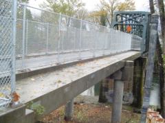
(Photo: Clackamas County)
After an arson fire burned through several key support columns in August of 2006, the 82nd Drive/Park Place bike/ped bridge (map) over the Clackamas River (between Gladstone and Oregon City) is slated to officially re-open tomorrow.
In a newsletter from Clackamas County’s Water Environment Services division, county Board Chair Lynn Peterson said, “We know the public is eager for this work to be completed…and the public can once again enjoy this important pedestrian and bicycle access across the river.”
More info at RiverHealth.org


Thanks for reading.
BikePortland has served this community with independent community journalism since 2005. We rely on subscriptions from readers like you to survive. Your financial support is vital in keeping this valuable resource alive and well.
Please subscribe today to strengthen and expand our work.
I am happy to see this reopen, as it provides a much safer crossing than having to use McLoughlin or the Park Place overpass @ I205. My hope is it is so well used, that vandals don’t feel safe doing their bad stuff.
I’m glad that this is finally going to reopen. Now, I hate to be a cynic, but how quickly would this have been rebuilt had it been motorists who had been inconvenienced with a detour of over 2 miles? As a pedestrian, that would be at least a 40-minute long walk. All of this when cyclists can’t use that short stretch of I-205 over the Clackamas.
Oh well, at least it’s fixed now.
Well, John, we can tell you when N. Vancouver avenue is fixed how long it would take. Currently, there’s still a significant and confusing detour.
But I’m guessing about two years: http://trimet.org/news/releases/oct23_line8reroute.htm
I’m happy to hear that this is opened finally. I turned around here once on one of my midwinter rides because the surrounding area was so confusing and scary for someone who isn’t familiar with it.
Hopefully the bridge is now arson proof, or if not, under close watch.
I might have to take a trip out there again and see what I missed.
At least with the Vancouver Ave bridge, the detour is only a few short blocks. And it’s in an industrial area, as opposed to being in the middle of a park. Unfortunately, living in Vancouver, WA, that is my preferred route in riding to Downtown Portland.
To be honest though, I’ll just slip between the barricades if no one official is looking my way. If the bridge can hold itself up, then I doubt the 200 lbs of me and my bike can bring it down.
Now, just wait until one of the Columbia River bridges is damaged. I bet those tens of thousands of commuters in their SOVs will get to the powers that be a bit more quickly.
As Vonnegut said, “Another flaw in the human character is that everybody wants to build and nobody wants to do maintenance.”
If you want to go to the bridge and you are coming from Sweetwater corridor, ride the trolley trail. It’s a little muddy this time of year, but totally cool. It starts at SE Park Ave near the top of McLoughlin hill. Just look above you and follow the telephone wires above your head. Now that the bridge is open, the trail continues around Clackamette lake. Eventually you can work your way back to the trail or River Rd. It’s a nice loop ride.
Was this the bridge for old Oregon City streetcar which made its last run in ’58?
amazing, many times have I had to detour around this, I’m even going to use it tomorrow! Another thing to be thankful for.
Err, where is this “trolley trail” that connects to the Springwater Trail Corridor? I’ve never heard of it.
zilfondel (#9) – hanmade is being a little premature. You can’t ride the Trolley Trail yet, but you can ride its right-of-way. The Trolley Trail is a multi-use path under development in Clackamas County from Waterfront Park in Milwaukie to Jennings & McLoughlin. It runs along the old EPTC railroad line that linked Golf Junction in Sellwood and the paper mill in Oregon City. When completed, it will be a 14′ paved path.
Currently, the right-of-way for the entire trail has been purchased or otherwise acquired, the entire length has been surveyed, and construction of the first segment is slated for 2010. A dirt trail runs along the current ROW from Park Avenue south past Roethe Road.
More info is available here:
http://tinyurl.com/647pop
http://tinyurl.com/5hnj5m
The Trolley Trail does not connect to the Springwater Corridor, it starts about 2 miles south. It can be easily reached from the Springwater via either SE 17th Avenue or SE Main.
Hank (#7) – yes it was.