

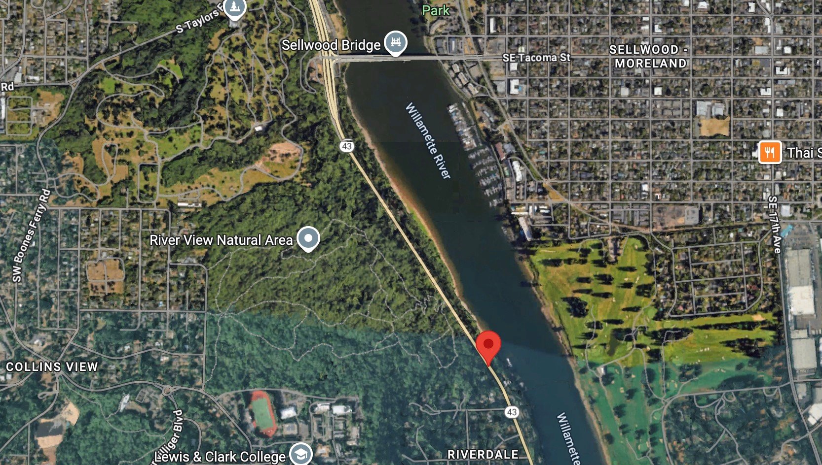
A person riding a bicycle has died following a collision with a driver on Highway 43 south of the Sellwoood Bridge. It happened sometime around 5:30 pm in the 9900 block of S Riverside Drive (Hwy 43), which is in an unincorporated section of Multnomah County between the borders of Portland and Lake Oswego.
Multnomah County Sheriff’s Office was able to make contact with the driver. No further details have been released. I will update this post as I learn more.
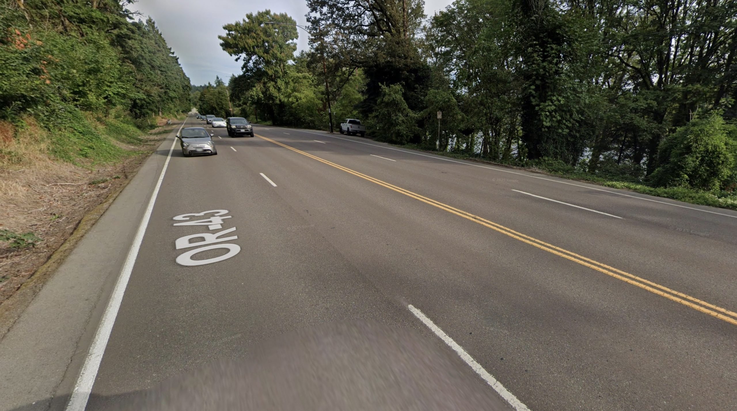
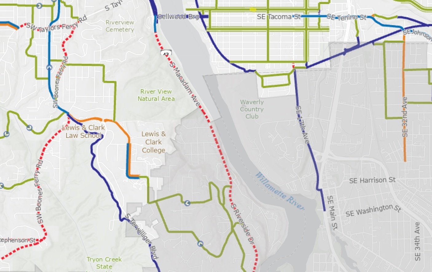
This stretch of road is a typical four-lane highway with no center median and no bike lane. The shoulder width is relatively narrow and the speed limit is 45 mph. It’s listed as a “difficult connection” on the City of Portland’s official bike map. It’s not heavily used by bike riders, but it’s reasonable someone would use this route to get between Sellwood and Lake Oswego (it’s visible on route heatmaps from Strava and RideWithGPS), or to access the trails at River View Natural Area. Most people would opt for the bike-friendly road through River View Cemetery, but access to that route has been unreliable and I’ve gotten reports recently that the gate is being closed at dusk, which would have been before this crash.
While it’s too early to speculate about the victim’s route or intentions, after I posted about this crash early this morning, several folks shared their thoughts. One person told me they live in Sellwood and attend Lewis & Clark Law School, which is very close to where this crash happened:
“This stretch of road is popular for bikes riding along the waterfront getting back on the bridge (especially for mountain bikers who ride the River View trails), heading east to Sellwood and for folks riding to Lake Oswego or into the Southwest Hills. Southbound has little to no shoulder for the majority of stretch and people very frequently speed far above the speed limit. I am rattled by this as a Sellwood resident and a frequent user of this road on my bike rides.”
Other folks say the crash has unnerved them. “I biked on this road once. Never again. It’s scary. Needs a bike lane at minimum,” one reader shared. “I’ve noticed the cemetery gates up top are getting closed even to bikes and pedestrians around 4:30, so more folks may be looking for work-arounds. This is scary to hear,” said another.
There have been attempts over the years to convert the old trolley line adjacent to this highway into a more modern rail line or a paved bike path, but strong resistance from riverfront homeowners, cost, and legal complications related to historical easements have stymied those efforts.
If you have any information about this crash. Please contact me.
UPDATE, 8:24 pm: Multnomah County Sheriff’s Office has issued a statement:
Based on the preliminary investigation, the bicyclist was traveling south, lost control of his bike after potentially hitting a rock on the shoulder of the roadway, fell, and was then struck by an SUV traveling south.
Initial first responders found a bicycle helmet on scene, which they believe the 68-year-old victim was wearing at the time of the crash.
The driver, a 32-year-old man, remained on scene.
At this time, no arrests have been made and no citations issued. Once the investigation is complete, it will be submitted to the Multnomah County District Attorney’s Office (MCDA) for review.
MCDA will make a charging decision based on the available evidence and upon conducting a legal analysis.
The bicyclist is identified as Rutilo Moreno Jorge.


Thanks for reading.
BikePortland has served this community with independent community journalism since 2005. We rely on subscriptions from readers like you to survive. Your financial support is vital in keeping this valuable resource alive and well.
Please subscribe today to strengthen and expand our work.
I think you understate how significant a gap this connection is in our cycling network. The only current alternative is going up and around by climbing up switchbacks through private property. And while very scenic, the path through Tryon Creek is twisty and bumpy. I do appreciate that both of these bike friendly routes exist, but a more direct route is desperately needed.
And given the relatively modest traffic counts south of the bridge, it’s insane that they still have this configured as a 4-lane highway.
Hi Chris,
I was house sitting at one of the houses across from where his happed and heard the commotion after paramedics arrived. It happened in a section of the highway where there are 3 lanes southbound and one northbound with a wide shoulder on the river (northbound) side. The cyclist was riding along the side of the southbound lane where there is only dirt and gravel about a tire wide and has a lot of brush leaning over it.
Yeah, I’d argue this is top 3 worst cyling connection citywide….Riverview shouldn’t even be in the equation because, as B.P. widely reports…it’s private.
I’ve ridden to LakeO dozens of times, never ridden on hwy43. F$%k No
I live in Lake Oswego and it’s awful to get into Portland / Sellwood on a bike. I believe Hwy 43 is an ODOT highway, meaning the cities can’t really touch it AFAIK.
Converting the trolley trail to a pathway would be amazing. It would be a game changer for micromobility connectivity between LO and South Waterfront.
Couldn’t agree more mperham! I really wish someone would take up this issue again. Or maybe BikePortland should! Especially now with with so many e-bikes in the fleet – this stretch between Sellwood and Lake O is perfect for e-bikes and a ton of people would use it.
I too, live and ride in Lake Oswego. I did some five, six years ago reach out to LO City Council on the Trolley trail conversion. The one council member that did answer was a Huge “No” “Won’t even consider”
If BikePortland would be the lead, I think a lot of us would support that.
I stopped riding Hwy 43 some two three years ago, I often drive to L&C area to start my less-car commute Portland. I appreciate the Cemetery for the allowance to pass thru, Its super cool of them to allow. I hate the Terwilliger bikeway thru Tyron, and thus end up on Terwillger itself, again a narrow no shoulder road way with speeds exceeding 40++
Where do we start? The most difficult part? How to begin and organize?
If I recall, the trolley trail easement through Dunthorpe will revert to private property if it stops being a railroad right of way. Ergo, it stays a rail line or the property owners get extra acreage.
it will never be a trail.
there was an interesting study hears ago to convert it to a streetcar but honestly they should extend the Max down it to Lake Oswego. If Portland were actually serious about transit, which it isn’t of course.
The MAX would be great, and could branch off the Tillikum without too much work. I’d say Portland is mostly serious about transit, but places like LO and Clackamas County are less inclined due to fear mongering of crime and “Portland creep”.
Since Highway 43 is underutilized they could potentially use it for a MAX alignment à la East Burnside or build a cycletrack. Perhaps the cemetery should close their gates for good and force Multnomah and Clackamas to do something.
One of the very first steps in deciding to run Max to Lake Oswego along Hwy 43 would be determining if there is (or will be) enough ridership to make it worth the expense and opportunity costs.
I don’t know the answer, but I suspect it’s something along the lines of “no way”.
Yes MAX to Lake O would be a disaster and would be very hard to defend. What we need to do is create a low impact vehicle (LIV) lane on Hwy 43. Maybe make it bi-directional on the river side of the highway so there’s less runoff and debris from the hillside. A LIV lane would be transformational and could be billed as an e-bike highway that is also open to other small vehicles. Or if that doesn’t fly, just call it a bike path and be done. There’s plenty of room, we just need some politicians and organizers with backbone.
Haha, could you imagine trying to cross from one part of your property to another across a streetcar or max rail? The trolly currently goes by every hour at most, but that’s based on ridership and if the volunteer trolly drivers are working that day.
The one house that does have a bridge is unique as their permits allowed for the structure. Many of the other houses can’t even get a permit to build something like that due to the slope of the earth below and erosion.
There is an OMTM route on RidewithGPS called Dark Side of the Lake. It routes on the trolley tracks from George Roger’s Park, through the 1935 trolley tunnel and eventually connects to the single track to the Sellwood bridge. I’ve ridden this a hand full of times on a “gravel bike”, and do not recall a house built on the tracks. Also, the trolly tracks are used by the trolly from Memorial Day to Labor Day. But, maybe I’m missing something there?
Aside from some footbridges, there’s one property that has a bridge connecting two houses here. I’ve also ridden/walked the entire ROW several times albeit years ago. AFAIK there are no other buildings encroaching on the ROW all the way to downtown LO. Unfortunately, Dunthorpe is not part of Portland or LO, just mult co. It’s raison d’etre is to remain isolated, so the best scenario is probably building a ped bridge across the Will R near the old UP RR bridge.
There should be a ped/bike bridge next to the RR bridge!
Join Bikeloud
Dunthorpe Patrol is a paid for service so they’re only security for the neighbors who pay for it. They also have a relatively large area to patrol compared to their low staff and only 3 vehicles. I grew up in that area and as I’m aware, none of the residents on the river stretch pay for DoPo.
Yes, one of the houses has a bridge over the tracks, but it’s in a uniquely safe position to do so. Most of the other houses can’t do that as they’re more on a slope with higher levels of erosion.
The interesting thing about that area and why the original plan was shot down is the property isn’t owned by Portland or LO who jointly run the trolly. The trolly has right of way to cut through the property of the homeowners. While a trolly is stuck to its tracks, there was no good way to assure the homeowners that people wouldn’t trespass on their land to either go up to the highway or down to the river (something that is a problem, but would get worse with more use as a path).
Picked up free stuff off Craigs in LO and riding 43 is always a near death experience.. Wh0regone roulette..
I commute daily from Portland to Lake Oswego and rely on the cemetery route as a safe way to navigate this stretch. When it’s closed to bikes before the end of the workday, it creates a difficult situation and the alternate routes, Taylor’s Ferry or Highway 43, are far less safe for cyclists.
It seems the closure happens primarily during the winter months, when it’s already dark by the time many of us are heading home. That’s exactly when having a safe, well-lit route matters most. I’d be grateful if the cemetery could remain accessible to cyclists through the evening commute hours.
@Marie Everyone who feels this way should reach out to Portland City Council, particular D4 but also if you live elsewhere in Portland to your reps as well. The Cemetery is a private entity. It is a nonprofit with a mission that has nothing to do with providing us safe routes for bicycling and walking. The City needs to step up and working with the Cemetery to create short-term solutions and a long-term real alternative to expecting a private entity to provide such a key route.
Zimmerman and Clark don’t seem responsive to non-car needs. Green seems supportive of cycling but is also super-distracted by just about everything else (homeless sweeps, Gaza. etc) so I’m not sure he’d be any help either.
If you get anywhere with any of them, please let us know so we can speak up and not worry about wasting our time.
I once rode through the cemetery after dark, it was the darkest riding experience I have ever had.
Re: “the gate is being closed at dusk” – yes, it has been since at least this summer, if not longer. The path thru the cemetery is also a much steeper and longer hill. The route up thru Riverview Cemetery and along Tryon Creek Park to Lake Oswego from the west end of the Sellwood bridge is 4.7 miles and 400 feet of elevation gain, with over a 6% grade, which Google estimates to take 33 minutes.
While Hwy 43 is only 3.2 miles and 170 feet of elevation gain and only takes 17 minutes: about half the time and less than half the elevation.
As a bike commuter who lives in Southeast Portland and works in Ssouthwest Portland, I can attest that historically no agencies — City, County, Metro, TriMet, or State — have prioritized safety for bicyclists and pedestrians in much of Southwest beyond downtown Portland. For decades, PBOT has expected a private nonprofit cemetery to provide 1.6 miles of routes for pedestrians and bicyclists, without the City developing any viable alternatives. (Nor has the PBOT developed safe connectors to/from the Cemetery, as this case underscores). It seems to take only a few affluent residents to persuade public agencies NOT to provide safe alternatives for the many people who need or wish to travel to, from, and through Southwest using active transit (bicycles, walking) or public transit. Yet the financial, environmental, and health burdens of expecting everyone to own and operate a private motor vehicle are evident.
Whether this bicyclist was commuting, running an errand, on a recreational ride, or bicycling for whatever reason, they should not have been put in this dangerous position, None of us should be. And yet, every day, through indifference, members of our community continue to be endangered, and too often injured or killed.
Plus you have this big college with no easy way to ride to it, effectively encouraging students to get a car.
Sellwood resident here. The amount of speeding I can hear on 43 where this crash happened is insane. Daily and nightly. Driving south on 43 past the bridge, the highway opens up and so folks feel ok gassing it. A speed camera or even an occasional actual cop would pay off here big time.
I’m super bummed to hear the cemetery is closing gates at dusk, will have to go check that out.
Jonno,
You must be new here….talk of enforcement is sure to bring you lots of opposition from many bike portland commenters—especially suggesting something like “evil racist cop” enforcement of our traffic laws. And we wonder why we have so many traffic deaths in Portland…..
The comment has 18 upvotes.
Let us know when your prediction comes to fruition.
The gates closed but, there is always a way.
This is sad to read, and too close to home. I occasionally ride on this stretch of Hwy 43, but avoid it whenever possible
I asked ODOT to address the bike safety concerns on Hwy 43 from the Sellwood Bridge through Lake Oswego and West Linn over 10 years ago, with detailed descriptions of areas of concern and photos. They responded that they looked at the areas and didn’t see the need to correct any problems. That stance still stings, and leaves me with little confidence in ODOT.
We shouldn’t have to rely on the grace of a private entity (Riverview Cemetery, which is closed at night, and occasionally at other times) to ride between Lake Oswego and Sellwood. Long term, our neighborhood association (Sellwood-Moreland) plans to lobby for a safe public facility to connect the west end of the Sellwood Bridge to southwest Portland and Lake Oswego. Hopefully we’ll get that in Portland’s new Transportation System Plan. But that could take decades to fund and build. In the meantime, our state transportation agency owns right of way they could reallocate to provide a safe bike/ped facility if they want.
Time to re-new efforts to lobby ODOT? Any constructive suggestions?
My employer, Lewis & Clark, has both many employees and many students who bicycle or walk to campus, or who wish they could if the routes were better. Scott, if the neighborhood association would like to collaborate, please reach out to me directly.
Lois, thanks for reaching out. Email me at transportation-chair@sellwood.org.
I’d start with reaching out to the ODOT Pedestrian and Bicycle Program Managers – statewide, and particularly in Region 1 do discuss a strategy.
Pedestrian & Bicycle Program Manager
Ian Davidson | 503-457-5920
Pedestrian & Bicycle Safety Manager
Heidi Manlove
Region 1 (Portland Metro)
Kerrie Franey
Telephone
971-990-9578
Thank You for posting this!
I have reached out to these folks and they were no help at all. Not sure why that was but I got the impression that cycling concerns just aren’t important to ODOT – they move cars and trucks and do mega-projects. The ODOT empolyees who handle bike and ped issues have zero power to change the status quo.
I feel like I saw somewhere that the Willamette Shore Trolley was revived and is running again? And that would seemingly remove the idea of a separated path. I could be misremembering though.
But this section of road really needs a road diet either way. The section of road immediately to the south of where the crash occurred already only has one northbound lane, so the additional lane at least to me seems pretty clearly not needed. And at least to me that suggests we could and probably should get rid of the second southbound lane as well, making this a standard 2-lane road with a center turn lane. The extra space should be converted into a wide two-way multi-use path on the east side of the road that connects on the north side with the existing path that exists north of the Sellwood Brifge, and on the south side to at least Palatine Hill Road (after which low-stress alternatives exist).
My condolences to the family of the rider who lost their life.
I love this idea- ODOT should install some jersey barriers tomorrow as a trial until next summer. IF traffic delays are acceptable, then it remains permanent and can be upgraded during the next road rebuild. The only thing stopping ODOT form doing this is will- maybe we need to pressure the governor?
Yes, the trolley is running again, and has shifted to solar/electric power for there very limited runs. Any trail would need to parallel the railroad, similar to the Springwater, but the ROW does not have width in many areas.
The Willamette Shores Trolley runs a cursory amount of service yearly as a heritage railway, at least in part to prevent the railway from being formally abandoned. If memory serves, they need to run at least one service per year.
I see no big downside to a path on the alignment even from an optimistic long-term passenger rail viewpoint. Any service from Wilsonville or Lake O to Portland probably is better of crossing the bridge and traveling on the east side of the river via Milwaukie than going via this line. The only downside would be not serving the west side waterfront – a Portland Streecar extension to the Sellwood Bridge via the trolley route would be an interesting idea at least.
I’m sure the biggest issue with making a path is dealing with the old trestles. It would definitely be an expensive undertaking to rehab or replace them. But it would be an awesome ride, and pancake flat relative to every other option to Lake O
Any idea how much rehab the trestles and tunnel would need for legal MUP use? I’ve seen a few people walk them despite how treacherous they are. Seems more a political barrier than an engineering one.
Since it’s not just plug and play and at least the trestles need some work, there’s the potential for legal issues related to reversionary rights and if the new trestles will allow for the corridor to be railbanked. Since it’s a post 1870s line, the most recent Supreme Court ruling on the topic requires a “railway use” to avoid reverting the easement to adjacent property owners. Since it’s a rich part of town, I just am assuming there will be a legal fight related to it.
So that’s political, but those issues will probably spill into higher engineering and planning costs.
The trolly runs over them so they are fine. I’ve ridden alongside from LO to Sellwood and it’s generally safe, but sometimes there are washouts you should dismount and walk around.
5:30 pm would have been near sundown, when light is most dim for everyone involved, usually the most dangerous time to interact with car drivers even when riders are well-lit.
I would not suggest adding a painted bike lane on any 4-lane that allows 45 mph. Speed limits need to be vastly reduced – a 3-lane road diet might be possible with buffered bike lanes and 35 mph, or maybe barrier-protected bike lanes and 40 mph.
According to ODOT, in 2023 the road (Highway 43 aka S. Riverside Dr at Riverwood Rd) had an AADT of 15,076 of which 6,741 were northbound and 8,335 southbound, with peak traffic on Tuesdays and Wednesdays. https://ordot.public.ms2soft.com/tcds/tsearch.asp?loc=Ordot&mod=TCDS
5:30 isn’t near sundown. It’s dark this this time of year
David lives in NC so you’ll need to forgive his occasional factual errors about Portland.
That’s well after sunset, twilight ends at 5:15 and there’s a hill on the west side.
One reason people speed is, they want to be first in line before the two lane section drops to one and everyone drops down to approximately the speed limit. Pointless. On the uphill that extra space would be really useful for anyone out there on a bike.
I’m sorry for this person and their family. I rode out 43 once scouting the commute with a friend who was interviewing for a job in LO. They didn’t take the job.
I don’t know that changing the speed limit would help — I doubt drivers pay attention to it, and if they even know what it is, I expect they’d just ignore it if it were dropped
I don’t ride this area often but know it well enough — definitely not great. I have no idea how the crash happened, but lighting would not be a concern for me personally in this area because no one has the sun in their eyes (in my mind, the most dangerous lighting condition there is).
Rather, getting clipped by someone drifting across the line is always my biggest concern — in the wet/dark with headlights shining in your eyes and from behind can make it challenging to tell what’s going on in the mirror.
It’s areas like this that need more attention, places with “reasonable” facilities don’t need to be reworked in the meantime. I have Lombard on the brain right now since there was a recent article about the bike lane there being deficient — all I have to say is try riding past Denver where everything moves much faster and there’s a nice high curb with no bike lane or shoulder and see if improving already-improved areas need priority.
David, at this time of year it is quite dark at 5:30 pm in Portland. The sun sets at 4:45 pm and civil twilight ends at 5:15p. So 5:15 to 5:50 is nautical twilight, where you need lights to see where you are going already.
I agree about the speeding on 43. Several years ago there was a large public meeting at 5 PM in LO about the proposed LO-to-Portland streetcar, which I and most other people there opposed.
The proponents said the streetcar was needed to alleviate the rush hour traffic jams on 43. I drove the whole way to the meeting on 43 at rush hour, and traffic the whole way was was at least 10 mph over the limit. I don’t know of another commuter route in Portland where you can speed that easily at rush hour. So a road diet seems logical.
The design of the approaches from north and south to the Sellwood Bridge don’t help. It’s designed like a freeway interchange, giving people the impression they should drive on 43 at freeway speeds (and the ability to do so). So they do.
The “highway” is already one lane in each direction as it tops out over the hill. There is absolutely no justification for 2 lanes in each direction, other than “I want to go 15mph over the speed limit”.
Why was the streetcar a bad idea?
At least south of Willamette Park, the line catchment area is very low density (half of it is water), and the local governments have no interest in adding Transit Oriented Development. It also would not have served very many middle or low income citizens.
It would be a great location for a bike path. Mass transit, not so much.
Seems like a better transit solution would be to run the 35 bus more frequently.
They could design a line with one stop between Willamette Park and Lake O (probably at the foot the Sellwood Bridge?), which would be a nice express service from Lake O to SW Portland. The real issue is that there just isn’t much demand for that.
My reasons (which I think were pretty much in line with those of others who opposed it, including the government decision makers):
–it would serve a small number of people compared to MANY other potential streetcar lines
–of the small number of people it would potentially serve, not many would likely switch from driving from LO to Portland, since most are well-off with an easy driving commute
–it was being pushed by someone proposing a new residential development in LO, and never had much support beyond that
–there was little opportunity for using it as a catalyst for development, since almost the entire route from LO to Portland is narrow, single-family zoning without much land to redevelop to higher densities even if the zoning changed
–at the meeting I was at with hundreds of people, I only remember two people testifying in favor–one who wanted to use it to go from LO to Blazers games, and another who was tired of going to the same LO restaurants and said he’d use it to eat out in NW Portland
I feel a bike/walking path would have way more daily users than the trolley. If I had to bike on 43 I simply wouldn’t …I’d have the bus cart me and my bike through that speeding corridor. My assumption is that the residents are opposed to creating a walkable/bikeable trail to replace trolley due to risk of misuse. It would be a tricky stretch of land to police and there would be overnight campers within a week.
Ok vehicular cyclists, where you at? Tell us why building a path would be “infantilizing”. Tell us why “taking the lane” on a 60mph highway is actually somehow 1 billion percent safer than a separated path. Tell us about how the cyclist was actually incompetent and we all suffer from “cyclist inferiority phobia”.
These tragedies are completely avoidable, yet many – including those in positions of power – refuse to acknowledge material reality.
Who are you yelling at? Who are the vehicular cyclists advocates on this site or in any position to influence anything? Yell or Email or lobby ODOT.
dw is the messiah of safetyism. I ride on 43 all the time – but almost never on the bottlenecked sections with poor sightlines. It’s not great but it’s doable and on par with most cycling infra in much of the USA, unfortunately.
I was involved. The man had a cardiac event and fell into the car’s back right tire, even though the driver gave him space. A tragic accident. There needs to be a bike lane here.
Oregon law requires leaving enough space so that even if someone falls into the street that contact will still not be made it appears that the driver did not “give him space”.
The law, which is based on a model of crashing that bears no resemblance to what really happens when a cyclist goes down, requires about 4ft of space when passing. What makes you think that the apparent first-hand account of what happened is wrong?
That feels like such a rude thing to say to someone who just saw someone die.
It was very intentional that the law does not say 3 feet or 4 feet it says enough space that if the person falls towards your vehicle you still will not hit them. That the person fell toward the vehicle and was hit shows that adequate space was not left.
You are right, and it would be much better if the law had such a clear standard.
Instead, the law imagines a cyclist “tipping”, and requires drivers to leave enough room for that. That is, in my estimation, about 4ft for a typical adult, if you start from the assumption that “no passing room” is already about 2ft off the cyclist’s center, or “tip point”.
Since people don’t actually fall this way, especially if they have a medical event as was mentioned here, or hit a rock as the Oregonian reported, the fact of collision tells you nothing about how much room the driver left.
Hell, if you hit a rock at speed, it’s entirely possible you would crash 10 or 15 feet (or more) from where you were riding. While current law is inadequate, no reasonable law can prevent every conceivable crash.
The law’s actual wording:
I agree that wouldn’t cover, say, a fall that was accompanied by first veering several feet into a lane, as could happen (or not) in a medical crisis or after hitting a rock. On the other hand, it doesn’t restrict “falling” to “tipping”.
https://codes.findlaw.com/or/title-59-oregon-vehicle-code/or-rev-st-sect-811-065.html
I was repeating what I was told by the lawyer at one of the legal clinics the BTA used to hold (back when they still did useful things; I took the clinic twice, several years apart). Ray may have been wrong, or case law may have changed the situation, but that was how he said it was legally understood.
But regardless, for our purposes here, if we agree that the law doesn’t cover “veering”, then we also agree that no evidence has been presented to support Bjorn’s assertion of fact that the driver was passing illegally close. (And if it does cover “veering”, then there is no save passing distance at all, which would be a farcical.)
I’m sorry but you are completely wrong when you say that it would be better if the law had a clear distance standard, because cops basically refuse to enforce 3 foot passing laws because it is too hard to judge the distance, and 3 feet isn’t enough space for a safe pass anyway.
So, better to have a completely unclear standard? And what is the “3ft” rule?
What was your involvement? How do you know he had a cardiac event? If the timing on these comments is accurate, JM made an update to this article with the police report a while after you made your comment. Why don’t you reach out to him with updates?
I’ve emailed that commenter just FYI.
The fact that you haven’t heard back causes me to doubt the varacity of the comment, and the commenter. I recall other similar comments along the lines of “I saw the cyclist run the red light,” etc. But there is never any corrobration.
Let us know if I’m wrong.
Often when a cyclist is killed, someone – always “anonymous” – posts about how the cyclist was at fault. I frankly do not believe this uncorroborated account.
OR43 is proven, to be deadly. Meanwhile the trolley line sits as an unused right-of-way running from the south waterfront right into Lake O. I know the monied elite in Dunthorp have long fought converting it into a rail to trail. And their concern about campers degrading their neighborhood is demonstrated to be valid if the Springwater Trail can be used for comparison. Still, the carnage must be stopped and Dunthorp can hire private security.
Always interesting when the police proclaim things like the cyclist “lost control” or a pedestrian leapt into traffic. There’s only one witness to the fatality: the driver. It’s easy to come up with a counter-narrative: the driver was texting, looked up and realized they were drifting onto the shoulder, for instance.
How do you know that?
I was there and the woman driving directly behind the driver witnessed the whole thing. The driver did everything they could.
So the driver moved over to the left of the two lanes leaving the legally required amount of space when overtaking the person riding a bicycle?
Anon! Identify thyself! Otherwise we shall not believe thee, or thy account.
reading between the lines fred, sounds like passenger in the motor vehicle involved in the collision.
I like how we can’t have a safe route that benefits many because a couple rich people don’t want it.
Portland Park could engage NWTA right now to get a 6-ft wide, gently graded gravel path though River View Natural Area.
It feels weird to rely on volunteers to great safe, separated infrastructure. But here we are.
The only “safety” feature I can recall ODOT doing on that stretch over the past several years is putting up some of those inane NO PEDESTRIAN CROSSING signs.
All this, let’s appeal to ODOT, let’s have a demonstration, let’s testify at meetings, honestly, it all kinda sucks. Look at Seattle though, their new mayor is a public transportation advocate, and NYC’s mayor elect is a member of the war on cars. THIS is what people need to do, run for office, vote for candidates who could shake the system up. Rich entitled people who have never taken the bus or rode their bike to work will NEVER understand unless people rise up.
I have found that after the gates of the cemetery close at night there is space to walk your bike around them. Is this not the case all evening long? (I ask, planning my commute)
Because the cemetery gate has been closed in the evening now, I traveled the 1.3 miles along 43 to get to S. Palatine Hill Road — the first right hand turn off of 43 that provides access beyond Dunthorpe — to check conditions. The “shoulder” is no more than a foot and debris makes it unrideable in many sections. Other sections of the shoulder are gone. As such, cyclists are on the road with cars traveling very fast. I passed a rider in the ditch who looked terrified to be on 43. I didn’t stop because I wanted to get off 43 as fast as possible.
Oregon’s recreational immunity statute may or may not cover commuting through the cemetery for work. Although cycling is now a “recreational purpose,” that doesn’t answer whether commuting by bike is “recreational.” So, as Lois writes, the city should enter into an agreement to indemnify the cemetery for any legal claims, should they arise. The cemetery is the only safe cycling route into this part of Portland. We need to preserve it. Please write to the D4 councilors.
This would be a good start, but I suspect the cemetery will not do anything that “normalizes” riding there — they want to be able to close the gates at their sole discretion, as they often do over Memorial Day weekend, and as they have threatened to do (or actually done?) in response to bad cyclist behavior.
Hi Jonathan,
Thank you so much for sharing this and updating it as you know more.
I was house sitting at one of the riverside houses and heard the commotion after the paramedics arrived. When I went out, I could see the cyclist in all dark clothing in the left lane (confirmed by the Sheriff Office’s statement). While that side of the highway does not have anything but a shallow and narrow ditch that is usually overgrown with brush, my vantage point was the car wide shoulder on the river side that most cyclists use.
A small correction to your post: While a lot of the highway only has lanes for traffic, where the accident happened there is a shoulder next to the northbound lane that runs all of the way to Sellwood Bridge. There, the pattern turns from 4 lanes and a shoulder to 2 southbound lanes and one northbound lane with shoulder. What an incredibly scary situation!
how fast was the driver going when they killed the cyclist? Why do we not have speed controls on this stretch of road? is it acceptable to just acknowledge that people speed here because they can?