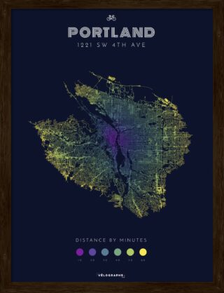
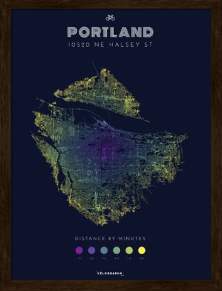
Here’s a cool gift idea for a bike lover or urbanist on your list: A customizable map called a Velograph that shows how far you can travel by bike in set time increments. A reader recently shared Velographs with us and pointed out that their creator is former Portlander Adam Roberts.
Adam lived in Portland from 2003 to 2014 and still has family in town. Portland is also where he went to school (PSU), worked for local bike nonprofits, and where he cemented a lifelong love of cycling. He now lives in Grenoble, France where he works for a mapping company.
I asked Adam to share a bit more about himself and Velographs.
What’s your Portland connection?

I moved to Portland in 2003 and lived there until 2014 when I moved to the French Alps. Portland is where I was married, it’s where both my kids were born, and it’s where much of my family either lives or gravitates. Probably not ironically, it’s also where I started seeing bicycles as a centerpiece of my life, and not an accessory. Having no car in Portland was not only not a hassle, it was liberating. I had dabbled in bike repair while at university, and soon enough I was wrenching at the Community Cycling Center (CCC), and then teaching for the safe routes to school program at the BTA (Bicycle Transportation Alliance, now The Street Trust). Portland State is also where I went back to school, and pursued a Mapping/GIS program, starting my cartography obsession.
Are you a bike nut who got into maps, or a map nut who likes to bike? Both? I’d love to hear the origin story of how you came to create and sell these maps.
All of the above. I’ve been mostly carfree for the last 25 years, so everything is filtered through that lens. I’ve always loved maps and data viz in general, but primarily because it represents something – a connection to the world. When you bike everywhere, you need maps, you need planning, and you need resources. I’ve been working on and off with projects that help me identify what activities I can do in an allotted amount of time on my bike. “It’s Saturday morning, and the weather turned out great – what can I do outside within a reasonable bike ride?” My current employer (Targomo) provides the tools to answer these questions, and that was one of the reasons I started working there.
This drive to discover reachable activities was cranked up a notch during the first of the Covid lockdowns – the only things we could do were outdoors, and there was a bit of a rediscovery of bicycles as a mode of transport for a lot of people. Targomo had also recently developed a method for generating super-fast graph-based travelsheds (or how far you can travel at a certain speed, also called a multigraph), and I was a bit obsessed with it. It looks so cool to see “topography by omission” – rivers, lakes, mountains, coastlines all visible simply because the roads have work around these features, or because biking uphill is hard. I had been playing around with these as a fun little art project of sorts when I showed them to my friend Ryan Morris (a fellow West Coast native living near me in Grenoble). He had the experience, design chops and general product knowledge to take my ideas and turn them into something really desirable.
Sure the maps look cool, but given the distance marker element you’ve added, I sense there’s a bit of advocacy you’re doing here? Is this a secret plot to promote bicycling?
Ha. Probably? I mean the travelshed tool can return the same representations for walk, car, and public transit as well, but (for me at least) visualizing the world you can reach by bike from your house is empowering – it’s not just road lines of your city, it’s truly your bikeable domain. Transit is also really empowering, but I consider myself an avid transit user, but not a transit nut, per se. There’s something obsessive about cycling (and cyclists) so there was really no question that I would focus on bicycling as the mode.
How long have they been for sale? What has the interest been so far?
They have been for sale for a few months, but there was no marketing or outreach, as bootstrapping a weekend project into a viable product is not exactly straightforward, and if it could work, it couldn’t create huge amounts of custom work for an order – all that had to be built-in. That was really where I stepped back, and Ryan took over – I’m good with data and technology, but business building isn’t really “my thing.” The interest has primarily been “Wow, that’s awesome!”. Now we hope that emotion turns into orders.
Anything else you want folks to know about these maps?
The poster design is shareable, so you can send pre-made ideas to folks you think would love it! (i.e. 60 minute cycle-reach from Tom McCall Waterfront Park.) Folks can also find us on Twitter @velographs, Instagram @velographsmaps and of course our webstore at at VeloGraphs.com.
Thanks for sharing Adam! Good luck on this cool project.


Thanks for reading.
BikePortland has served this community with independent community journalism since 2005. We rely on subscriptions from readers like you to survive. Your financial support is vital in keeping this valuable resource alive and well.
Please subscribe today to strengthen and expand our work.
Seems like a cool project and a nice gift for a bike/transportation nerd.
Obviously you can chose the avg speed scale, which is nice, but these travelsheds really make it clear how slowing down bikes curtails their utility vs cars for longer crosstown trips. Averaging 15mph across Portland is not that easy, with stops for lights and stop signs. Every time I see new bike infrastructure built that includes sharp bends, weird car priority crossings, and narrow pinch points I think about how much it will reduce the effectiveness of bikes to replace cars.
Especially with the explosion popularity of e-bikes, I’d like to see some sort of network of bike highways that plan for “high speed” biking in large numbers. Even concepts of “bike expressways” are basically a wide single lane each way.

Absolutely agree. Just look at how relatively unpopular the Tillicum and Morrison Bridge crossings are compared to Hawthorne. One is fast and direct, has no out of direction travel and or slow signals, the other is slow and ponderous. I know which I prefer!
Just FYI, the default speed the maps are based on is 10 mph. I upped it to 15 just for fun. Folks can set a variety of different speeds to play with the bikeshed.
Yeah, and toggling between the two supports my point. Looking at the maps side by side makes clear that avg speed is very important to usability of bikes as everyday transportation. Some engineers and planner might not think it that much of a loss to design a new “improved” bike treatment for 10mph vs 15mph or higher. But looking at the difference in bikesheds, especially in 30-60min rideable range, it’s really clear how much it would curtail reasonable commute radii.
For example, at 10mph St. Johns disappears from downtown default Portland map. At 15mph, it’s in the 60min zone. Same goes for anything east of 205.
I wish I could still keep a 15 mph average pace… in Portland. 😉