A long awaited plan from the Portland Bureau of Transportation recommends a slew projects that could set the stage for major changes to a key east-west corridor.
When the Columbia Lombard Mobility Corridor Plan kicked off over two years ago, we said it could unlock massive potential. Now that it’s been released for public review and comment, has the plan lived up its promise? The plan recommends several exciting projects that would definitely move the needle for cycling and create new places to ride where few – if any – people dare ride today.
Here are a few highlights of the plan…
Columbia Blvd
PBOT’s main goal with Columbia is to recognize its importance as an industrial and freight-centric corridor, while making it safer for everyone. In this plan, Lombard is the street where they recommend more cycling-centric changes, but there are a few projects on Columbia that are very notable (as we think about this plan, keep in mind that Columbia is owned by PBOT and Lombard/US 30/Killingsworth is owned by the Oregon Department of Transportation).
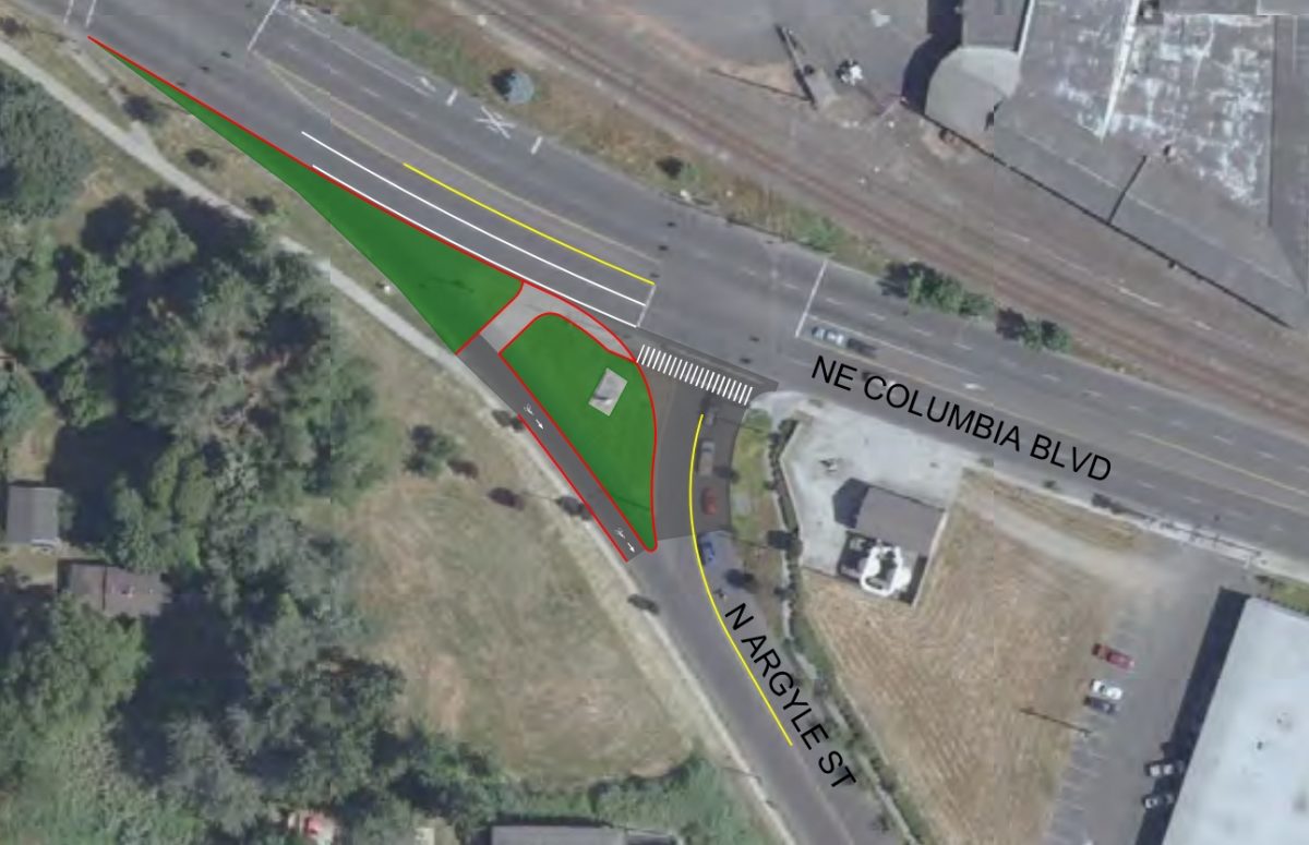
Just north of Kenton Park, PBOT wants to reconfigure the Columbia/Argyle intersection. The plan calls for removal of the eastbound slip lane from Columbia to Argyle. This would create a much safer condition to the existing path/sidewalk on the south side of Columbia. This path goes all the way to St. Johns where you can connect to other paths (via a signalized crossing at N Portsmouth) all the way out to Kelley Point Park.
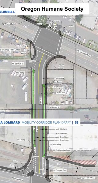
Safer access to Oregon Humane Society is long overdue! This popular destination has been held hostage by dangerous road conditions for way too long. PBOT’s plan would redesign NE 11th between Lombard and Columbia with a new striping, medians, bike lanes, and other changes. OHS has agreed to re-align their main entrance to 11th so folks don’t have to navigate an off-set crossing of Columbia to pick up their pets.
Advertisement
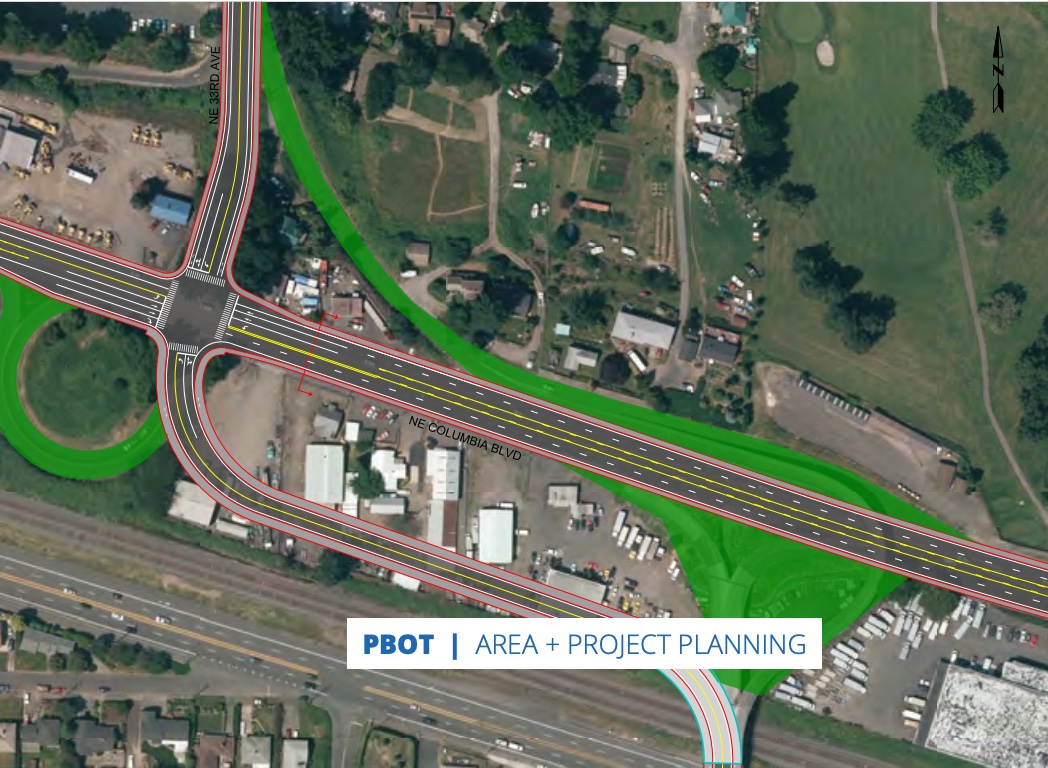
This is a big one. NE 33rd is a key north-south connection to the Marine Drive bike path. Getting over Columbia is stressful in both directions. In the near-term PBOT wants to improve the bike lane to avoid the need to merge across NE 33rd Ave when headed northbound. They’d also re-stripe Columbia and make changes to the NE 33rd Drive corkscrew so that riders don’t have to share a lane with high-speed drivers.
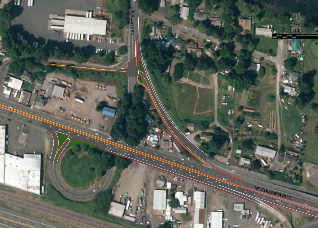
In the long-term, PBOT’s plan would dramatically reconfigure this interchange. They’d get rid of the flyover and the corkscrew ramp and direct everything toward a much safer and more predictable, 4-way signalized crossing of Columbia. “While this project would be expensive and have substantial right-of-way impacts, it would also simplify traffic movements, allow for continuous bicycle/pedestrian facilities…” the plan states.
Lombard St (US 30 Bypass)/Killingsworth
Because it is less industrial, Lombard offers more potential for bike facilities. On the flipside, it’s maintained by the Oregon Department of Transportation and still carries a high volume of freight traffic, so adding bikeways will require careful negotiations and planning.
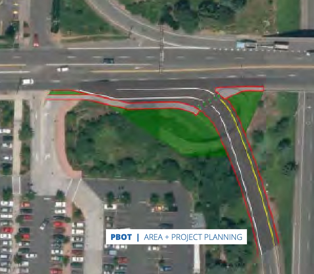
One of the first recommendations that caught my eye was to remove the cloverleaf pedestrian ramp over the I-5 southbound on-ramp near Fred Meyer. This iconic structure is really neat, but it’s also a relic of the past. This crossing of I-5 is currently horrible, so it’s good to see PBOT put forward plans to reduce turning radii and tame drivers.
Unfortunately, PBOT has not chosen to endorse bike lanes and a road diet on Lombard between NE Mississippi and NE Martin Luther King Jr (below). Despite a terrible crash history, rampant speeding, and community support, PBOT says, “the road width and current traffic volumes make this difficult.” “Reducing four lane roads to three motor vehicle lanes and adding bike lanes would improve safety for all road users, but based on current traffic volumes (~13,000 vehicles in each direction) this would have a high impact on travel times, intersections and parallel routes,” they continue.
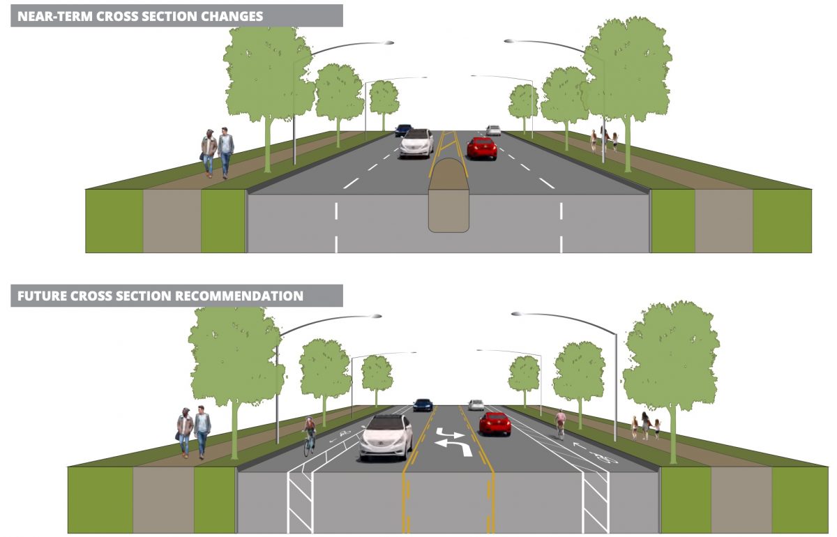
In the near-term, PBOT says this section of Lombard should be restriped with a wider centerline and parking should be prohibited on the north side. They’d also add a few left-turn pockets (at N Albina for instance).
While they don’t have the guts to reduce driving capacity right now, PBOT that when traffic volume drops below 10,000 vehicles per direction, a road diet and bike lanes would be considered. This stance begs the question: How will we meet our mode share goals if we are unwilling to proactively re-allocate roadway space from driving and toward other uses?
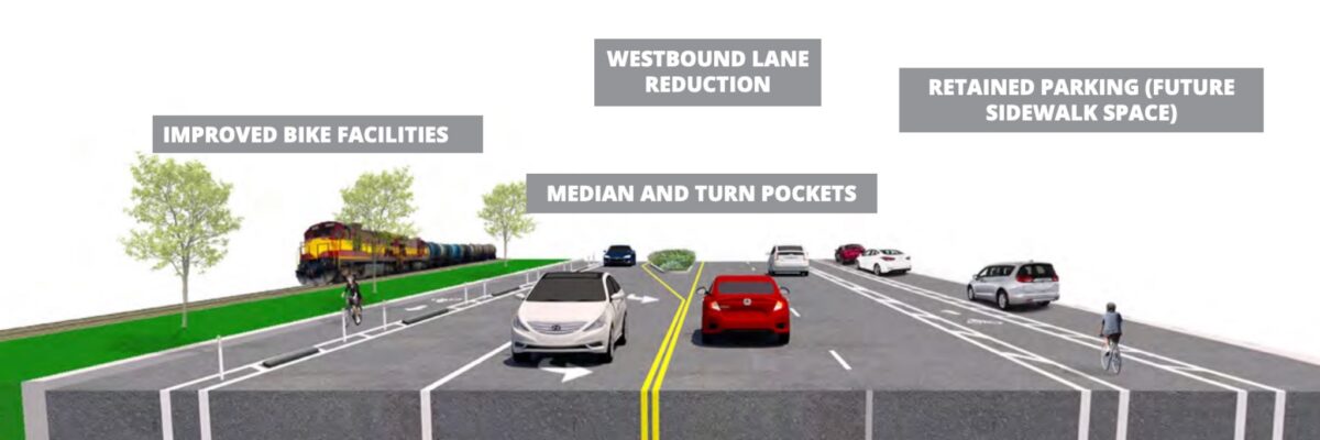
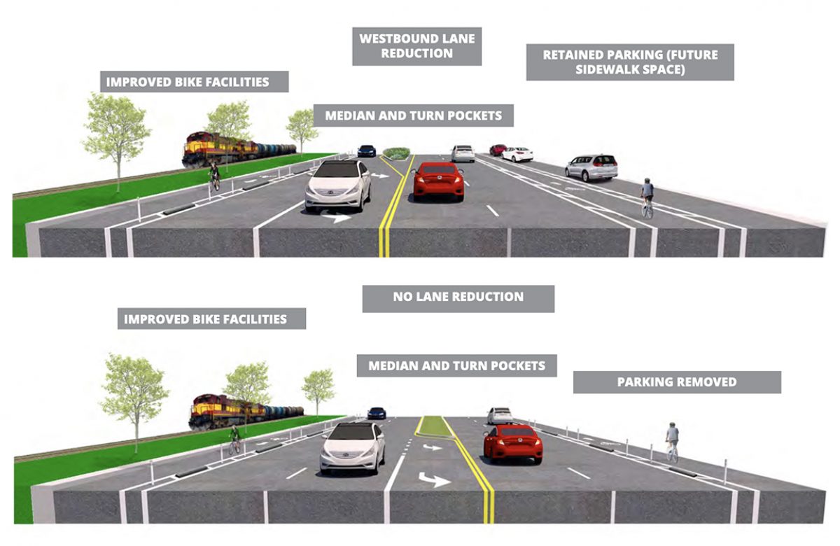
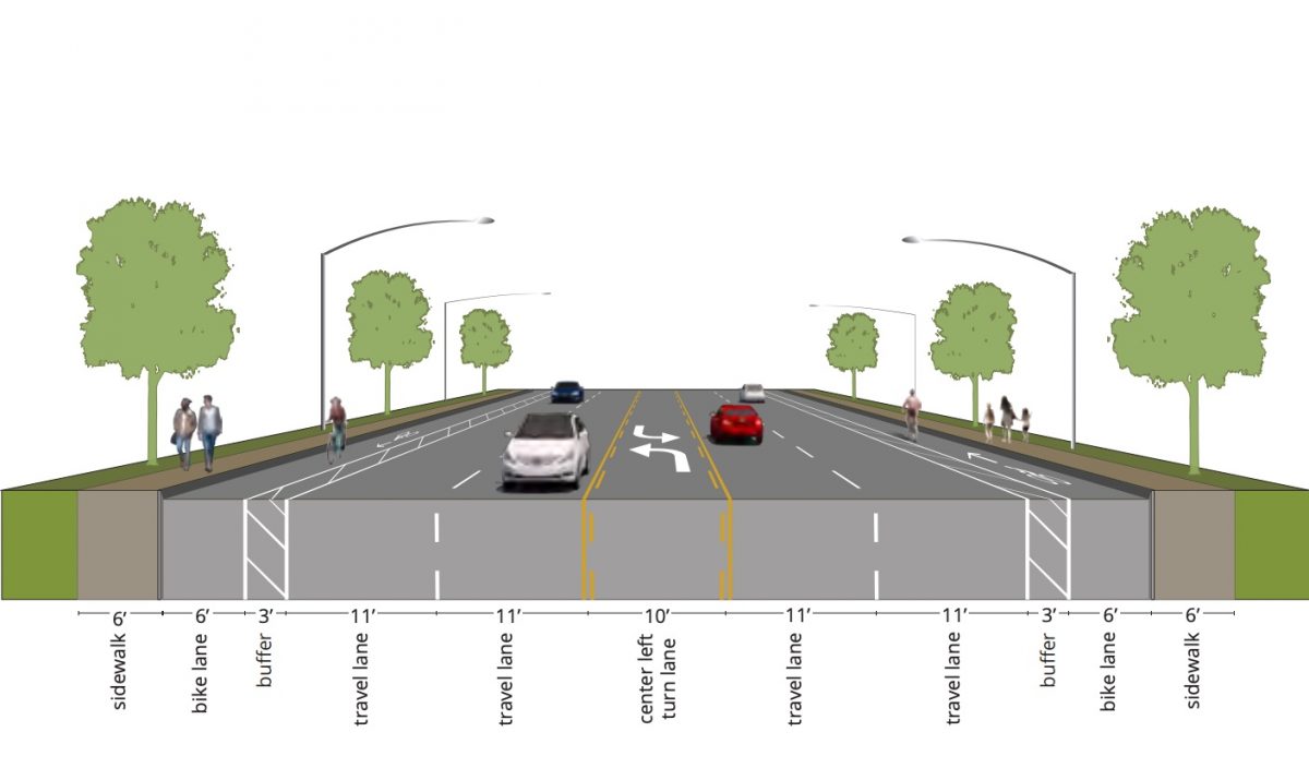
On a brighter note, I was happy to see a recommendation for wider, protected bike lanes on Lombard between 11th and 60th (although we’d need to make them much more protected if we want people to ride in them). PBOT has shared two options for further consideration.
Option 1 would reduce driving space in the westbound direction. “While this reduces the capacity of the road for motor vehicles, it still allows traffic to flow consistently at most times of the day,” the plan reads. It would maintain on-street parking on the south-side with an eye toward the future where the parking could be converted to a sidewalk or more robust, grade-separated bike lanes.
If the driving lane reduction in Option 1 isn’t feasible, PBOT has created Option 2 . This would add a center median and maintain two driving lanes in each direction “In this scenario,” the plan states, “it is even more critical to separate bike facilities from traffic and reduce the high rates of speed through signal timing, speed reader boards, and automated enforcement.”
East of 72nd, PBOT would restripe the lanes to create space for wider, buffered bike lanes. (It’s unfortunate to see buffered bike lanes on a major arterial context like this without physical protection. For some reason PBOT is still not placing concrete in these buffered areas as a default.)
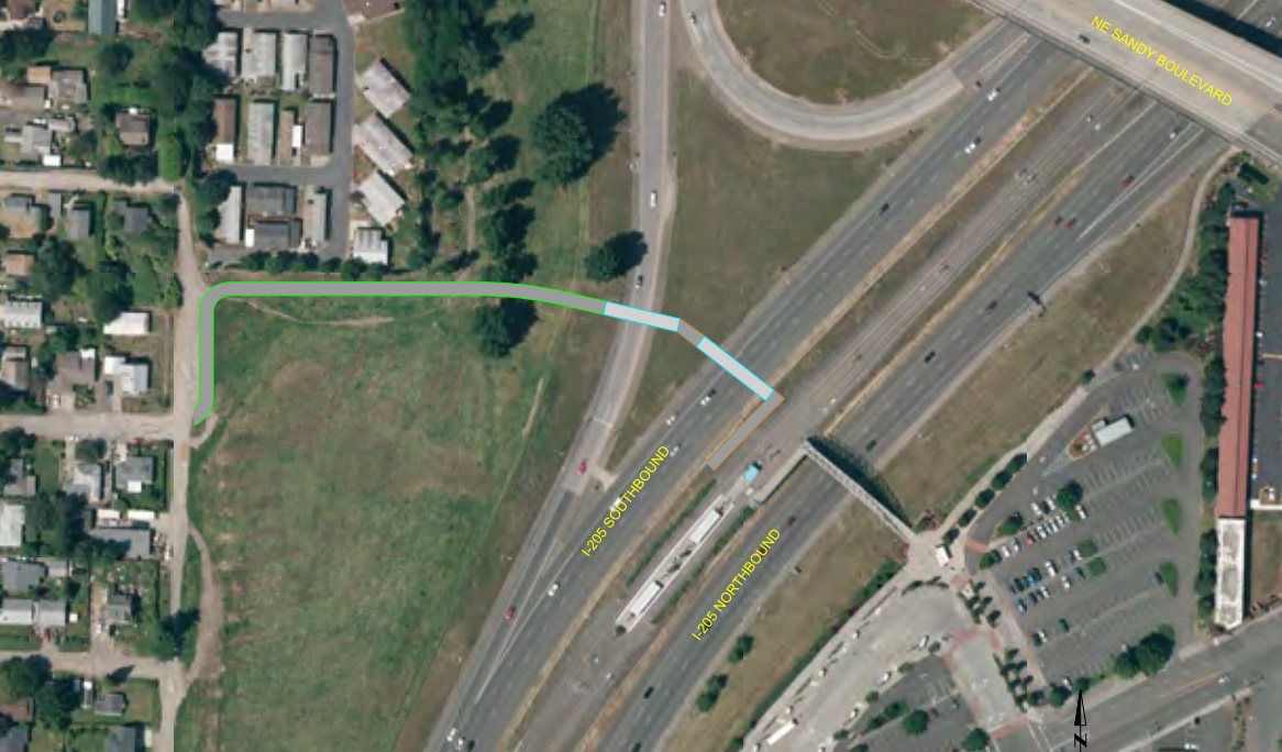
Adjacent to I-205, PBOT recommends a new carfree bridge over the freeway to connect the Sumner neighborhood to the Parkrose/Sumner Transit Center. This would eliminate the need for people on foot and bikes to use Sandy or Killingsworth and create a new connection to the I-205 path.
These are just a sampling of what’s in the plan. PBOT’s other recommendations include a new bridge over I-5 at N Winchell and new sections of the Columbia Slough Path.
While they’re still just concepts at this point, they now have the full weight of PBOT behind them. From here it will be up to project advocates (like you) and city staff to find funding and push further to get them implemented. For more details and to share comments, see the project page at Portland.gov. The plan is expected to be adopted by City Council in the coming months.
— Jonathan Maus: (503) 706-8804, @jonathan_maus on Twitter and jonathan@bikeportland.org
— Get our headlines delivered to your inbox.
— Support this independent community media outlet with a one-time contribution or monthly subscription.


Thanks for reading.
BikePortland has served this community with independent community journalism since 2005. We rely on subscriptions from readers like you to survive. Your financial support is vital in keeping this valuable resource alive and well.
Please subscribe today to strengthen and expand our work.
Your write-up appears to assume that PBOT owns Lombard and Killingsworth. Those are ODOT-owned state highways.
Thanks Momo. Will edit to clarify.
I thought PBOT owns Columbia, not ODOT like the article states. Am I wrong here?
If I’m correct, I kinda wish that ODOT and PBOT would swap ownership of the roads. I’d be fine giving Columbia (an ugly arterial street that wouldn’t be pleasant to bike, walk, or run on even with a protected cycle track because of all the industry) over to ODOT and not investing any in it apart from at crossings, with PBOT in turn taking control of Lombard and protected bike lanes being added.
I agree. It seems Lombard/Killingsworth are much more suburban and residential and would benefit the most from ped/bike improvements. Freight heading west to or through St Johns seems to already be using Columbia. for example, when driving to St Johns, I often get routed to use Columbia anyways as its faster. Wouldn’t the slower/residential route be the one getting the bike/ped focus? Also bike/ped improvements are being built right now on Lombard west of this area anyways…
Jonathan, now the article says both Columbia and Lombard are owned by ODOT. Columbia Blvd is owned by PBOT, and Hwy 30 Bypass (Lombard / Portland Hwy / Killingsworth) is owned by ODOT.
Fixed now! Sorry about this. Sometimes my brain has trouble working. Wish it was easier to remember who owns/manages what!
https://gis.odot.state.or.us/transgis/
Go the above website, click on “Classifications” then click on “Federal Functional Class – State” box and then click “Apply.” That will show you the ODOT roads.
I stopped riding down 33rd, but it wasn’t because of the flyover.
It’s still part of my regular circuit, but you have to take the lane through the camps, which can make it hairy at times. Not really all that much different from the roads where the bike lanes are full of gravel. I definitely wouldn’t ride through that section in the dark, though.
Between the disaster on 33rd and the problems on the 205 MUP I’ve pretty much given up riding anywhere near Marine drive anymore.
ODOT and realistically PBOT need to figure out what they want for Lombard. It has the highest potential for any street in the city in my opinion. Tons of apartments are being built on Lombard in North Portland, some in North East Portland. The section east of MLK has plenty of space for BRT/LRT and runs the entire length of the city. Lombard already has a MAX stop at N Interstate and could easily have one that connects to the red line.
The N Interstate/N Lombard corridor could easily be some of the densest real estate outside of downtown if the city and state had any vision.
The biggest problem is that ODOT has made sure the street is dangerous for pedestrians and non-motorized transit.
Lombard would be a fantastic LRT corridor, and would provide service to neighborhoods like St. Johns, Cully and Woodlawn that have never been adequately served.
After the SW Corridor failed I had a fleeting hope that Metro would reflect on and abandon their insistence on building long, sprawly, expensive LRT lines out to the burbs but that got killed after their first meeting back when they decided the project was perfect and that it was the voters that were wrong.
We need to look at our neighbors to the north. Seattle is rapidly building out its transit system with short spurs in high density areas and we are over here building long spurs in low density areas and hoping, without any evidence, that those areas become dense. A four mile spur on N Lombard would connect 100,000+ Portlanders to the MAX system the day it’s completed.
I completely agree. I live two blocks off Lombard, it is a residential and retail street, there is no reason for it to be a state highway with (potentially) 18 wheelers navigating it 24/7/365. Although we don’t see a lot of heavy truck traffic on the N Portland – St Johns sections, as the only Willamette River crossing near the N Portland industrial area is the St Johns Bridge, there is a lot of heavy truck traffic in the downtown St Johns area and it is downright dangerous. The state should consider adding a second Willamette River Crossing in the industrial area – although due to the river traffic it will need to be a bridge of sufficient height to allow ships to pass beneath (a tunnel is likely out of the question.
I think that a streetcar along N Lombard from St Johns to N Interstate turning into MLK and going to the Lloyd District to meet with other streetcar lines would be fantastic. It is well reported that rail based transit attracts significantly more route side development than bus based transit does. Developers perceive rail based transit as a significant public commitment that will not be abandoned capriciously – the same cannot be said of bus based development. Most riders prefer rails to roads – the streetcar is not going to divert suddenly for no apparent reason.
Excited about the changes shown here, especially the long-term vision for 33rd. I absolutely hate that section where it dumps you onto Lombard.
The proposed bridge at Parkrose Transit Center would be awesome, especially if built in conjunction with a signalized crossing of 82nd at Alberta, and a MUP connection through Sacajawea Park. This would create a continuous low-stress bike corridor between Parkrose and the rest of NE Portland. Right now, the options from Parkrose are all terrible. It would also increase the walkshed of the Parkrose transit center. The MAX red line is really under-utilized, and one big reason is the fact that so few people live near the stops.
A little confused. It appears that in last photo NE Killingsworth is mis-labeled NE Sandy.
That’s true!
That stretch of Killingsworth (from Cully to I-205) will soon be NE Lombard.
What’s the advantage of the wands? It seems they offer an slight illusion of protection perhaps. Perhaps they are just inexpensive?
On streets with four lanes of fast moving traffic, you’ve got to go for more significant protection and separation between the modes. People are still going to get injured or worse with these designs.
The long term goal should be an elevated MAX line above Lombard branching off the existing Yellow Line to St. Johns. St. Johns has been underserved by transit for years and this would provide a high quality and speedy service.
That would be amazing!
An elevated line might be overkill, but a MAX on Lombard would be fantastic. I think a better option would be a rail station on the current Amtrak line at the cut through N Portland, which IMO should be part of a greater planning process of the CRC 2.0. Connecting Vancouver, N Portland and downtown with frequent rail would be amazing.
If we build a new elevated MAX line, it should be on Powell between the Orange Line and I-205. Elevated lines are expensive, so the corridor needs to sustain high ridership and add value to the system. Connecting the I-205 line with the Orange line and Tillicum would create the possibility of several new lines (Clackamas direct to downtown, Gresham to downtown via Powell, Airport to Clackamas, etc). It also creates redundancy by offering the green, blue and red lines an alternate routing away from the Steel Bridge bottleneck.
Lombard is actually wide enough to have a MAX line running down the middle, but I question the value given the density and land use of outer-Lombard. You have a railroad line on one side, and low density houses on the other. Probably not a great candidate for increased density, either, because the area is generally unattractive (airport, railroad noise, industrial pollution, etc). Inner Lombard is a different story, though. A spur from the Yellow Line west/NW to St. Johns would probably make sense.
Absolutely, the Powell line should have been priority over the SW corridor based solely on connectivity (its ability to augment the current network), density, and support for rapid transit. The metro Powell project was incredibly successful at simultaneously garnering interest in LRT, and quashing any interest by eliminating it early on as an option. Powell to I205 as a true multimodal corridor would be an amazing asset to the SE metro area, as well as the entire region.
That Sumner bridge would be great for accessing the I205 path from the west. I would rather take that than risk crossing Sandy at Going, even with the on-demand blinker. Of course, if the Prescott and Sandy I205 path underpasses remain unsafe the Sumner detour might not be very attractive anyway.
Crossing 82nd is still a problem — Prescott is not a great choice… the best option seems to be cruising past the massive Beech trees along 81st and waiting for a lull at Going and 82nd.
This area is truly awful for connecting to East Portland. Sandy needs separated bike lanes for almost its entire length. Picture Foster Road, but actually usable. The Sumner bridge is fine, but it’s not a replacement for a cycle-track on the S. side of the Prescott bridge.
I agree. I’d never cross Sandy at Going. Easier to ride sidewalk on north side of Sandy to connect to MUP. But for now with camps blocking path it’s not worth accessing MUPs anyway. This is a prime area for “bikes belong on sidewalks “ which is what I do in this area. I don’t really believe bikes belong on sidewalks but I’m out there trying to stay safe.
As for crossing 82nd I do it almost daily at Alberta. The light just to the north gives a traffic break as does the light at Prescott to the south. Also there’s a center turn lane to give a momentary break although a designed “safety island” would be even better.
A new bike/ped bridge over I-5 at N Winchell would be an amazing way to connect Piedmont/Farragut Park to Kenton and other points west & north. Crossing the freeway at Lombard is awful and Bryant Street is great but quite a bit out of the way for folks living north of Lombard.