Whenever a carfree bridge over the Willamette River is being built in our region, it’s worth knowing about — especially when that bridge is the lynchpin that will someday connect 1,000 miles of paths and trails in the Portland region with the 134-mile Willamette Valley Scenic Bikeway.
I’m talking about the French Prairie Bridge project. And it’s time to do some bridge shopping.
Advertisement
It’s been nearly six years since we reported on one of the grants that helped fund this project. As we shared back then, the City of Wilsonville sees the bridge not just as a way to connect people to the Willamette Valley, but as way to boost tourism and economic development. Wilsonville is currently smack-dab in the middle of a 30-mile gap of surface street crossings of the Willamette River.
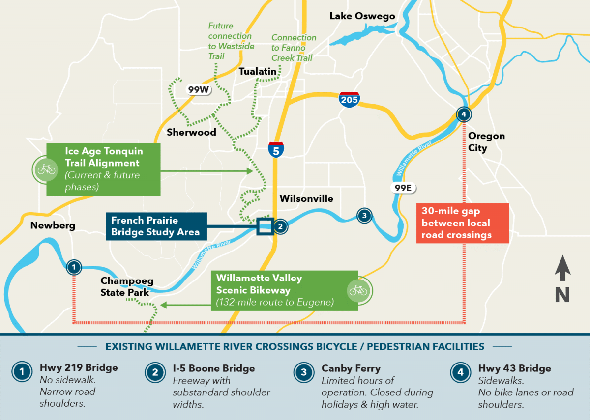
People in the Portland area who want to reach the Willamette Valley (and the great bikecamping destination of Champoeg State Park), have to cross the river at Oregon City or Newberg. Having a safe crossing at Wilsonville will be a major improvement. The bridge will also hasten development of the Ice Age Tonquin Trail which will eventually connect Wilsonville to Tualatin via the Fanno Creek Trail.
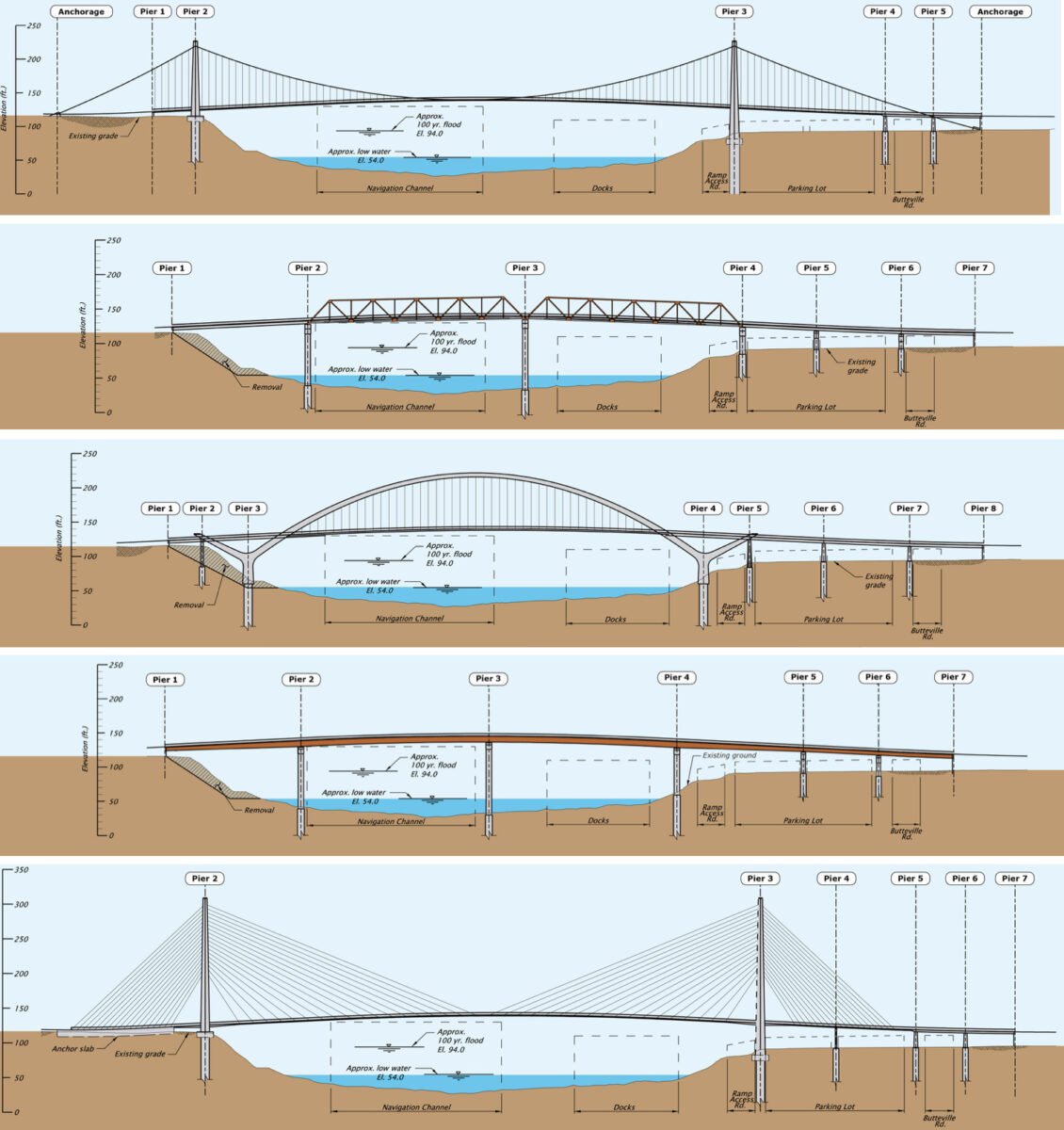
The City of Wilsonville is nearing the end of a two-year planning phase. With an alignment chosen and money in the bank for development, all that’s left to do is decide on the bridge type — and then build it!
The online open house is going on now through October 30th and your feedback is needed. There are five designs under consideration and there’s a great open house page that has all the details on each one to help you share informed feedback. All the designs will come with a 17-foot wide shared path. Final design will be selected in Spring 2019.
— Jonathan Maus: (503) 706-8804, @jonathan_maus on Twitter and jonathan@bikeportland.org
Never miss a story. Sign-up for the daily BP Headlines email.
BikePortland needs your support.


Thanks for reading.
BikePortland has served this community with independent community journalism since 2005. We rely on subscriptions from readers like you to survive. Your financial support is vital in keeping this valuable resource alive and well.
Please subscribe today to strengthen and expand our work.
I’d go with what’s least expensive. We don’t need a showpiece in that location.
We can always upgrade later if the demand justifies it.
A. Why build a bridge twice?
B. This would never happen.
Cost isn’t just based on the appearance. More expensive options have benefits regarding the impact to the river during and after construction.
This is true, but it looks like we’re talking two additional in-water supports here. I wouldn’t say that would be a huge impact, especially for such a narrow bridge. Given the similar bridge just downtstream, it seems like the basic steel option would work just fine here. I’d rather have another pedestrian bridge at another spot (LO to Milwaukie, for example) than a fancy bridge here.
I’d go with the design best suited to withstand a subduction zone earthquake.
This bridge is also intended for emergency vehicles, and the Web site lists “providing a seismically resilient route to support post-earthquake responses and recovery efforts” as a key project benefit.
Actually, I’ll apply the “least expensive” strategy to anything that doesn’t put piling in the river. No sense building obstacles for boaters or collecting wood on pilings during winter floods.
I rode over the I-5 bridge once many years ago on a ride down to Salem. It wasn’t pleasant, but it was doable. Riding a bike on the freeway ramps was probably the most nervous part. Certainly not recommended for anyone except skilled riders.
All for this, but the emphasis on a 30 mile gap seems a little far fetched considering what a good current option the Canby Ferry is, not to mention I-5 if need be.
I personally would never consider I-5, especially if I was with people like my kids or friends who are not as gonzo as I am.
And Canby Ferry is nice.. But it is not reliable 24/7/365 like a bridge would be. And the Ferry will not do much for economic development in the area.
There are some group rides that use I5 shoulder, it’s wide, just can be dirty and hostile. Know some people that do it solo sometimes. The Ferry is nice but more an adventure in itself and pretty intimidating roads to get to it.
Butteville rd from the base of this proposed bridge to Champoeg is an amazing road I would have no issue riding with my family. Being able to cross here and ride it would be amazing. Especially since on the Wilsonville side there is a path that goes under the Freeway bridge and connects to Memorial park through the neighborhood. Add in the Tonquin trail connection and this would be a serious improvement towards recreational and maybe even transportation cycling if an improved route to the Charbonneau community was made.
I second your opinion, Jonathon. I’ve ridden over the I5 crossing with the Portland Wheelmen, ONCE. Never again. There was the usual glass, gravel, and metal garbage for a road shoulder, but also broken pallets, an entire desk, exploded truck tires, you name it. The freeway shoulder is not suitable for cycling.
For that matter, the hwy 219 crossing is also nerve-racking; no real shoulder and very little road width for drivers to get around cyclists at the 50-60mph people drive.
The French Prairie bridge can’t happen soon enough.
How about a separated path along the railroad ROW instead? Oregon has very few miles of separated trails. How is one to reach this bridge safely from Portland without riding on hiways?
Boones Ferry Road north of Wilsonville was recently redone. and WES can also be an option.
I was in Wilsonville for 10 years and part of this future project, locals on other side of the river are fighting it 🙁 currently only way to get across is via I-5 and the ferry.
Oh yeah, has it been dubbed the “Crime Bridge” yet?
(Actual onetime Vancouver campaign against MAX: “Vote NO on the CRIME TRAIN!!!!”)
If you truly are gonzo, JM, you ought to write like Dr. Hunter S. Thompson.
My elderly mother lives across the river in charbaneau, and it drives me crazy that I have to dust off my 25 year old car and get out on the highway with the auto zombies to visit her. I rode the shoulder of I5 once and never again. During the week I could get to Willsonville from Beaverton on the Wes train faster than in a car, but the last mile by bike is a bummer. Any bridge would be better than what we have now
SMART does provide some weekday bus service to Charbaneau if you wanted.
A (I think) major point the post left out is that this is not just a bike bridge, but is also intended to be used by emergency vehicles, such as if an incident or earthquake were to close the I-5 bridge. This can make it more justifiable, possibly draw more/other funding and be a response to anybody who complains about lots of money being spent on bicycling.
Pretty is nice if it can be done within a few percent of the cost of the cheapest option, but otherwise just get it done. It’s a needed project, not only for bike tourism but for emergency response, especially after the inevitable mega-quake.
For the record, I never attempted biking the Boone Bridge. I did take my child bike-camping at Champoeg once (and the bike camping area is indeed excellent), using the Oregon City crossing on the way there and the Newberg crossing on the return leg. At Newberg you are riding along the shoulder of a moderately busy highway, but it’s not terribly narrow. Not particularly pleasant but not horrible (unlike what I’ve heard about Boone).
I suppose the Canby ferry would be nice for some, but I’ve heard there’s an enormous hill on the north side. Not something I would have wanted to use on the way back to Portland, pulling my child and camping gear in our not-very-granny-geared cargo bike.
The I-5 shoulder is kept more clean than Beaverton-Hillsdale Highway’s bike lanes and shoulders.
Fourth-to-last one is the best. It allows people to have the best views. No other designs compare.
Actually, I’ll apply the “least expensive” strategy to anything that doesn’t put piling in the river. No sense building obstacles for boaters or collecting wood on pilings during winter floods.