


(Photos: Madi Carlson)
Call me crazy, but I have four different routes for each destination. In order of comfort, high to low:

- me plus kids riding separately
- me with kids attached via cargo bike/tandem
- me alone
- me alone running late
They sometimes have a bit of overlap, but they’re rarely entirely the same.
I’ve made a couple interesting discoveries about my route choices lately and it’s got me thinking about how I choose my family-friendly routes and why they’re better for more than just biking with kids.
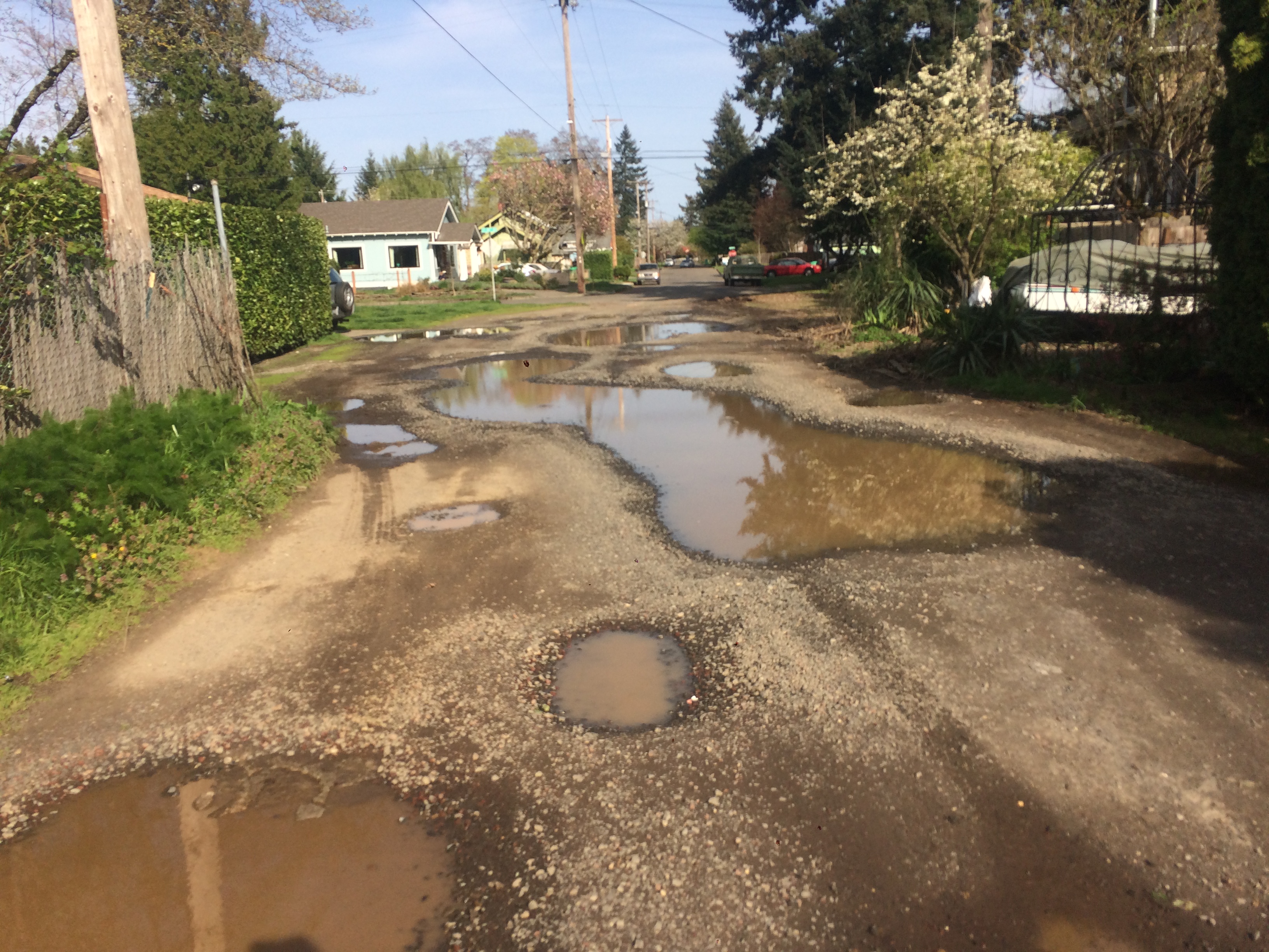
Two days ago I biked around with a friend visiting from Seattle and I realized that if we took my kid-friendly route we could ride side-by-side and talk the whole way home. That certainly seemed worth 31 minutes versus 28 (per Google Maps estimates). Then yesterday morning the kids and I left home a bit late so we forewent our usual out-of-the-way route that incorporates six blocks of fairly car-free “roadway not improved” pothole-strewn gravel and I realized how loud the direct route is. I take this direct route when I’m alone, after I’ve dropped the kids off at school and on my way to fetch them at the end of the day. Until yesterday’s shouted conversation, the noise pollution eluded me.
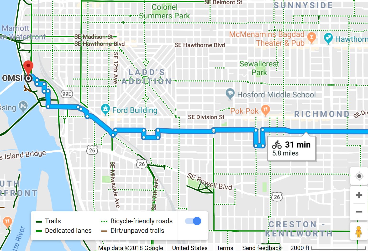
As an example of my different routes, here’s how I get close-in from the Woodstock/Mt. Scott area:
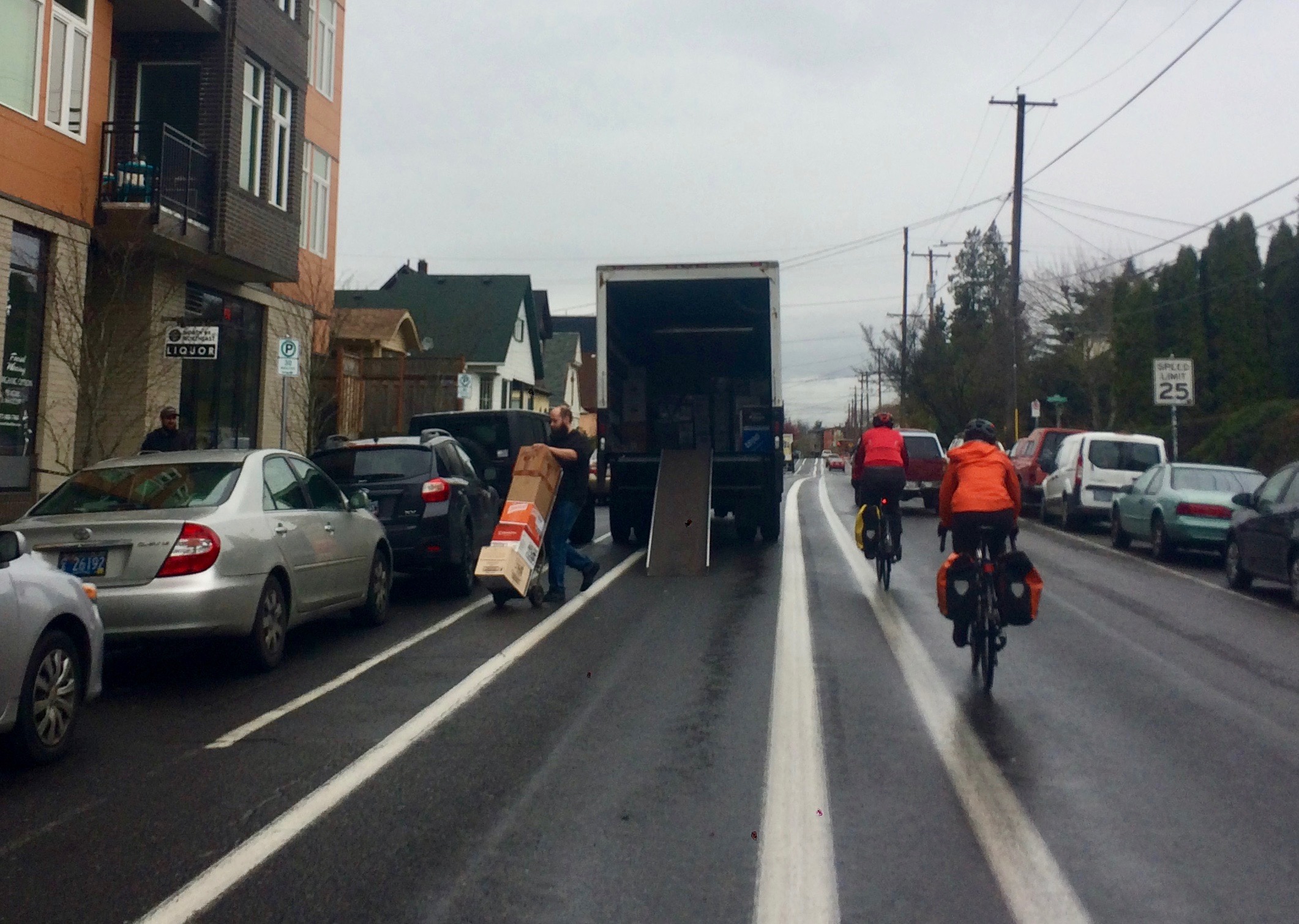
➤ If I’m alone or have the kids attached to my bike I’ll take the bike lane (a mixture of in the door zone and against the curb) of SE 52nd Ave and head west on SE Clinton St, my favorite greenway.
➤ If I’ve got the kids with me and one or both is on their own bike(s) we head the “wrong” way to use quiet SE 67th Ave for a light to cross busy SE Foster Rd and then wiggle over to equally quiet SE 65th for a light to cross extremely busy SE Powell Blvd (at the intersection with the furniture store dressed in anti-road-diet posters) and connect up with Clinton.
➤ If I’m rushing to a meeting after dropping the kids at school I’ll bomb down SE Steele St which has bike lanes the last few blocks, but mostly nothing.
I’ve come to understand “it’s not that steep”/”it’s not that busy” and “there’s only one steep block”/”there’s only one crappy block” are hints that I probably won’t like a certain route and will take all future advice from that person with a grain of salt.
When I started family biking 10 years ago I never went anywhere kid-free, so I developed my calmest routes first. But now that we’re in a new city and they’re at school six hours a day I often go new places without them and unless I’m investigating a kid-friendly route for future use, I tend to be lazy and just follow Google Maps. I need to break this habit because I’ve been using the same non-kid-friendly routes over and over without trying any small changes to find calmer alternatives for even parts of my trips. It might just be that I had more time to find my routes back in Seattle, but I think it really was easier — primarily because there are so many fewer greenways. That really helped limit my options.
Hills are an issue for kids and heavy bikes here, but they’re even more of an issue in Seattle and that also conveniently dictated where I could ride. Thirdly, I’m still getting used to the lack of stop lights for crossing arterials here. There really aren’t that many spots where kid-friendly streets have a light or all-way stop for crossing busy streets. For example, to cross SE Woodstock Blvd (which is only two lanes, but it’s busy!) I could take the kids to that door-zone bike lane (or sidewalk) of SE 52nd Avenue I mentioned before so we just wait for a break in traffic. The next light is 20 blocks away, for an even busier arterial.
So when I’m alone I consider bike lanes on arterials the lesser of two evils because at least I can cross big streets with a light. I’m a pretty stubborn person and bad at asking for help…unless it’s for bike routes. But I wouldn’t ask just anyone for help to find a route I’ll find pleasant for traveling with kids. I’ve come to understand “it’s not that steep”/”it’s not that busy” and “there’s only one steep block”/”there’s only one crappy block” are hints that I probably won’t like a certain route and will take all future advice from that person with a grain of salt. But if you can find a friend with the same temperament for traffic and hills (downhills as well as uphills, they’re both not as fun with heavy bikes or kids riding on their own) utilize them!
Advertisement
My go-to route advice giver is Kath Youell of the Portlandize blog. She knows all the best intersections and sneaky routes around any hills. She’s started posting some of her “flattest routes” on her blog, too. I have yet to find a spot Kath can’t route me to, but if I did need a backup source, it would be the PDX Cargo Bike Gang Facebook group. The group contains “strong and fearless” bicyclists, family bikers who share my route criteria, and everything in between.
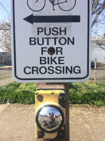
Crowdsourcing directions always yields interesting results. Obviously I’m biased, but I find family bikers to give the best route advice. They’ll also know of kid-friendly cafes and places to stop for restrooms along the route. The Interactive Digital Bike Map of Portland (or non-interactive Citywide Bike Map or links to these and all the other Bike + Walk Maps) is also terrific, though I have to say I’d mark at least 100 more spots with the “Difficult Intersection” red circle. I’d love a map with all the especially nice bike infrastructure and even just all the spots where quiet streets have stop signs, stop lights, or button-activated flashing lights (RRFBs) for crossing busy streets.
Fewer hills and the lack of lakes and their ripple effect of curving roads makes for such a nice grid here and it’s fairly easy to navigate between favorite friendly intersections.
And I still do plenty of looking at maps on my own, too, before I ask for help. Routing on my own doesn’t have to entail following the first option Google Maps presents. I find that’s a good starting point and then I do a lot of peeking at intersections and road widths with Google Street View. Google doesn’t have all the “Except bicycles” diverters accurately cataloged so it’s also wise to check any weird jogs in Google Street View. I used to be good about clicking “Send feedback” and submit photos and map screen shots in the hopes of getting bike-route errors corrected, and I’m putting it on my to-do list to start that up again.
And Google Street View is out of date for the other, but it’s a good guess that they’re both car diverters and fine for bikes to pass through. Google isn’t the only game in town, of course. Ride with GPS’ Find a Route and Strava Heatmaps are also sources for finding routes. I tend to think of them as routes for the “strong and fearless” set, but that’s not always the case. In person on the fly I’ve recently discovered a couple short cuts by following commuters when they leave the signed bikeway. Usually these are purely short cuts and replace one quiet block with a busy one, but sometimes it’s a quiet left-right-left jog to avoid a stop sign and a nice trick to one’s repertoire.
My on-the-fly route-finding claim-to-fame in Seattle was spotting a rare non-e-assisted pedicab and following him uphill from the waterfront through a lovely new-to-me plaza and along a road with a doable grade. To this day I’m always tempted to follow very heavy and/or wide bikes for the kinds of routes only they can fully appreciate.
Do you have any general tips and tricks? And any specific routes or parts of routes worth sharing? I’m sure there’s a lot I haven’t discovered in my almost eight months here. Thanks for reading. Feel free ask questions in the comments below or email me your story ideas and insights at madidotcom [at] gmail [dot] com.
— Madi Carlson, @familyride on Instagram and Twitter
Browse past Family Biking posts here.
Get this and other BikePortland posts delivered directly to your inbox.
BikePortland needs your support.


Thanks for reading.
BikePortland has served this community with independent community journalism since 2005. We rely on subscriptions from readers like you to survive. Your financial support is vital in keeping this valuable resource alive and well.
Please subscribe today to strengthen and expand our work.
I wish google maps showed elevation on your phone! Ugh I hate being out & routings on the fly and getting stuck with a super hilly way!
Me too! I seem to have a knack of finding all the hills.
Google mobile will show you a terrain map (same menu where you choose default or satellite views). It’s not as good as a elevation profile, but it at least is easier to spot the steepest hills along the route.
There are a bunch of apps that can map elevation profile that are designed for cycling. Strava was already mentioned, but MapMyRide, RideWithGPS, and Veloroutes come immediately to mind but there are others. The only ways to mitigate hills are to take a longer route that spreads the elevation over more distance, reduce weight on the bike, and change gearing — options which may or may not be available.
One thing I haven’t seen mentioned on BP that prevents people from cycling is making sure people have bikes that are right for them.
Would-be riders don’t understand equipment compromises and often buy based on style alone. Local culture favors heavy bikes with heavy accessories — this makes a noticeable difference on any grade and will be outright painful on the steeper stuff. Add in the flatland gearing you’ll see on a lot of cruisers and “normal” people find themselves unable to climb the hills they can’t avoid. Likewise, throw in some headwind when they’re already having trouble getting the bike moving, and they’re not having a good time.
Style is important, but people won’t ride if it isn’t fun. My general observation is that many of the least fit riders try to work with the hardest bikes to ride which leads to a demoralizing experience before you add a single car to the picture.
E-bikes can help with the pain factor, but they cost a lot to buy and much more to maintain — a big deal for people who aren’t already dedicated cyclists. On the roads, I can’t help but notice that I’ll see the same e-bike riders for a few months and then they disappear.
Great article!
I am contractually obligated to point out that the PBOT Bike/Walk Maps (of the 5 quadrants) show all the signalized intersections. Or try to – we keep adding more signals (I’m including rapid-flash beacons), which we endeavor to include on the next revision of each map.
I’m also a fan of TriMet’s multi-modal trip planner ( https://ride.trimet.org/#/ ) for getting alternate suggestions to Google Maps’ bike routing.
MULTI-MODAL TRIP PLANNER! I need to use that! Is Portland the only city with one?
Yeah, seconded on the multimodal trip planner. Generally way better than the Google.
Wow, thanks for pointing out this tri-met site, specifically the bike & multi-modal options.
For myself, I’ll ride most anything, though I much prefer low-traffic, low-stop sign routes that get me there quickly; once in a long while I do come across such a unicorn. For getting the grandkids around, I always check possible routes with streetview and such, then I go ride them myself at the appropriate time of day/day of week. Very few routes make the grade to be granddaughter-quality. I have no idea how this works for “normal” families that have to do it on the fly. No wonder we have so few families on bikes.
We jog left-right-left to avoid stop signs near home and it’s so satisfying! I like alternating orientations for two-way stops to keep driving to a safe speed.
I do a different kind of right-left jog when travelling sans kids – to make crossing a busy street easier sans traffic light, I turn right on the busy street (taking the lane) then make a quick left. That way, I only have to wait for and verify one direction of traffic is clear at a time. Usually faster and always less stressful and annoying than doing a constant 180 degree head turn to check both ways while waiting for that synchronized gap in traffic.
I don’t use route planning tools, and I would never send or take someone on a route I didn’t know from direct personal experience was appropriate for them. What constitutes a good route ultimately depends on the rider.
In any case, some of the advice is outright bad in that it appears based on how sections are classified rather than how they are and doesn’t account for shifting conditions.
When talking to non-cyclists about the need for infrastructure, I often point out that one of the primary differences between driving and cycling is with the former, drivers most often plan their routes based on the quickest way to get to your destination. Cyclists, on the other hand, often base their plans on the safest route to a given destination.
This is a very relevant topic, Madi. I reckon I’m like you: I’ll use Google’s recommended bike route as a starting point, and then tweak it according to my preferences. I’m curious how Google comes up with bike routes. I guess it avoids very high traffic, high-speed streets if possible. But when dangerous connections are unavoidable, Google doesn’t flag them and instead traces them in the same blue hue as the rest of the bike route. I wish it would flag these dangerous segments. My first months in Portland, I found myself on bike on outer NE Killingsworth and once or twice on Columbia Blvd. Horrible streets for cyclists — insane for those with kids. Now I know.
And I wonder how Google’s bike-route finder discriminates between lower-traffic streets? Example: for a couple years, we commuted between the Roseway neighborhood and Trillium Charter School (a few blocks from Portland Community College across I-5). The Google recommended bike route sticks to NE Skidmore for most of the trip. Not a bad cycling street, but there’s a wonderful Greenway (Going Street) a couple blocks over. Why doesn’t Google recommend that? It didn’t seem to add any distance to the commute and if felt safer and faster due to stop-sign priority.
Anyway, yes, Google’s usually a good starting point, but you’ve still gotta use your own head. Probably a good thing.
The complexity of route choice and following is IMO one of the top 10 barriers keeping mode share down in Portland. For the non-geographically-inclined, following even one poorly marked, winding route is a huge barrier, much less discovering that route or remembering and following multiple routes for the same destination for different purposes!
My personal anecdote: My husband gave riding to his job 4 miles away a shot. The route could not be simpler in theory – a straight shot down the 205 path with well-known streets and sidewalks on either side.
But… The Flavel gap. He got desperately lost at the gap, got to work late (he works at a hospital so this is a Big Deal) and never tried biking to work again.
Your anecdote is precisely why I tell everyone I recommend commuting by bicycle to pre-ride their route on a day off. There are so many factors to get right when bicycle commuting that knowing the route, however simple, should be something you get out of the way before you need to be at work. You may find that a hill takes way longer to climb than you expected, that you should pack this or that thing with you, that you will need this or that at work when you get there, whatever. So many things get worked out when you do the pre-ride and if everything works well for you, then you just enjoyed a fun ride. An option for some people is to bring their bike to work with them and ride home from work. This splits up the effort of bicycling the distance into 2 days and they effectively do their pre-ride when they don’t need to be at work at a set time.
Another thing to keep in mind is your equipment. Is your bike ready for commuting? What if you have a flat? Do you know how to change it? Do you have the right tools, a spare tube, a way to inflate it?
Unfortunately, it seems that this conversation alone deters most people on the fence about it but I prefer that outcome to someone having a bad experience or worse.
Alex, I totally agree about the greenway routes and the many gaps in Portland’s bike network being one the biggest obstacles to cycling. I wish PBOT would focus more resources on fixing gaps. BikePortland did a great write-up on the many gaps after someone was killed trying to ride a gap not id’ed on a bike map. There was even a map people could contribute to, if I remember correctly. I would love to see that map brought back and turned into a list of projects! My least favorite routes/gaps are Going between 7th and Interstate and the 70’s greenway between Mt Tabor and Tillamook.
Yep, gaps are a big deal – and winding, indirect, poorly marked/signed greenways and MUPs are also a big deal. There is just no comparison between how easy it is for my husband to stick a location in his GPS and get directed there on a fast, comfortable driving route (or guess his way there along the big streets) and how daunting/impossible it is for him to pick and follow a comfortable bike route to a Portland destination on the first try. He’s not unusual – we who are able and willing to tolerate this level of confusion and inconvenience are the unusual ones.
I’d add in the suggestion of using the Strava Global Heatmap (google it), which gives a really nice visual of the most popular routes chosen by folks who use the platform.
And yes – these are often sportier riders that would identify as strong/fearless, but at the same time they are largely in favor of “smooth” routes that avoid stops. And generally they are high mileage riders who have learned the best streets over time. So I tend to trust them!
A heads up that you need a Strava account (free) to zoom in to a worthy level.
There is so much great info here.
I’ll add something that I use in an area that’s unfamiliar. If I need to cover a stretch and there are multiple options, I use google to see which roads have a center-painted stripe. Then I go for the roads which don’t have one.
I think it’s psychology, but drivers seem more insistent on staying in their lane and close-passing if there’s a line dictating the lane edge.
I’m curious if others experience this.
Also SE Gladstone (26th-42nd) is the only road with a bike lane that I’ll regularly use. Otherwise the risk of dooring is not worth it.