What did cycling routes in Portland look like over 40 years ago? That’s something we’d never known until coming across this “From here to there by bicycle” map.
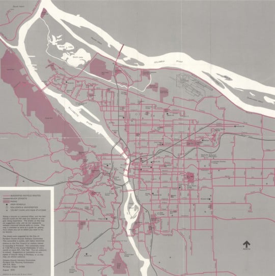
This map shows a robust network of streets recommended for cycling. It was created in 1975 and the streets were chosen by the City of Portland’s Bicycle Advisory Committee (a committee that still meets today). Keep in mind while you look at it in detail (below) that this map doesn’t necessarily show bike-specific infrastructure like bike lanes. That’s because there wasn’t much of that type of thing on the road yet. Portland had just passed its first bike plan in 1973 so it was at the very beginning of the bike network that would later earn us a place as the undisputed leader for cycling in the U.S.
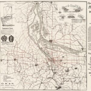
This is the second-oldest Portland bike map I’ve ever seen. The oldest is the amazing “Bicycle Road Map Portland District” published by Cunningham & Banks in 1896 (and endorsed by the Multnomah Wheelmen).
While the 1896 map is fun merely for its age, what I think’s more significant about this 1975 version is that it was created by the City of Portland. Is it the first ever map created by the bureau of transportation? Perhaps one of our friends from PBOT (hello Jeff Smith!) can enlighten us in the comments.
Scroll down to view the map…
Advertisement
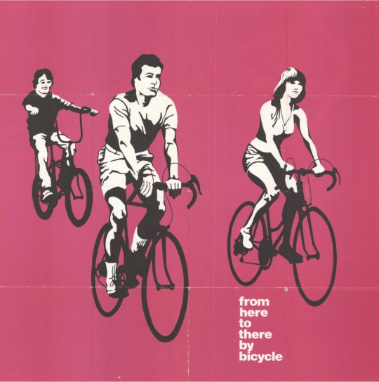
I also love how this map is clearly not intended solely as a utilitarian resource. This is a marketing and promotional piece. Today we call this “encouragement” and in fact PBOT has an entire group of staff devoted to it (called “Transportation Options” and housed within their Active Transportation Division). Besides the eye-catching pink color and the welcoming illustrations of classic 70s era riders on the backside (not wearing helmets!), we know it’s part of a promotional effort because of the text in the map’s legend. Here’s what it says:
Riding a bicycle is a personal affair, and the best bicycle routes are the ones you discover as you gain riding experience. The streets on this map are suggestions only, and do not necessarily indicate improved bicycle paths or routes. This map is intended to serve as a guide for getting from where you are to where you want to be, by bicycle.
Another fun thing about this map is how it helps us gain perspective on how far we’ve come in four decades. There are almost no cycling routes suggested in all of downtown from the Steel Bridge to I-405. And of course the once-possible Mt. Hood Freeway, what is now SE Powell/Highway 26, doesn’t even exist. Southwest Barbur Blvd isn’t there either. On the other hand, some of our most important and popular cycling streets are on there: the North Vancouver-Williams couplet; the Southeast Clinton, Ladd, Madison connection, and so on.
What catches your eye?
If you’re interested in how Portland’s bikeway network has evolved, check out the animation we put together a few years ago with map graphics from PBOT bike coordinator Roger Geller.
— Jonathan Maus, (503) 706-8804 – jonathan@bikeportland.org
BikePortland can’t survive without subscribers. It’s just $10 per month and you can sign up in a few minutes.


Thanks for reading.
BikePortland has served this community with independent community journalism since 2005. We rely on subscriptions from readers like you to survive. Your financial support is vital in keeping this valuable resource alive and well.
Please subscribe today to strengthen and expand our work.
What catches my eye?
The Schwinn Sting Ray and the cycling fashions on the map cover. (not necessarily in that order)
Is that Bud Clark riding his family to The Hollow?
I think you mean “The Goose”.
Yep. Love the Stingray! It was my first bike.
Barbur Boulevard isn’t even on the map. Also, look how many routes just end when they hit downtown.
I love that none of the people on the cover are wearing helmets nor hi-viz. No sarcasm.
“not wearing helmets!”? Surely they’ll catch cold or worse!
I have been riding since LBJ was sworn in riding back from Dallas in Air Force One, and I didn’t get a bike helmet until the mid-’80s They just did not exist in any great numbers before then.
I road my bike to elementary and middle school in the 70s. I not only road without a helmet and hi-viz clothing but I also did not use a light.
(I distinctly remember installing my first unreliable bottle generator light in high school.)
I have a question as to why some people are so against Hi-Viz apparel? Is it “Dorky”? Seems like it provides you the best opportunity to be seen by motorists. Why the vitriol for bright clothing on this site?
I’m not against hi-viz. I’m against victim-blaming, which usually goes hand-in-hand with calls for hi-viz.
Hi-vis puts the burden of safety upon the vulnerable road user, and not the user that actually causes the harm (the driver).
Though if someone wants to be a ninja at 1am with no lights on an empty street, some level of care must be made when turning corners with obstructions around them.
More so if the ninja did not realize they just turned the wrong way on a one-way street.
mah bad.
So, when someone gets shot do we blame them for not wearing “dorky” Kevlar, or do we blame the shooter? When someone gets hit, do we blame them for not wearing “dorky” HiViz, or blame the driver for “not seeing” the cyclist?
It’s easy to get caught up in the blame game with different sides to so many issues. I feel like it’s important to be careful about what you say in a public forum. I’ve read many times on here that someone “wouldn’t be caught dead in Hi-Vis”… funny choice of words, actually.
My fear is that a casual reader and newer cyclist, such as myself, might stumble upon this type of rhetoric and make the choice to wear dark clothing b/c bright colors aren’t ‘cool’.
Stay bright, be seen and stay alive out there.
The remarkable safety record of bike share users, who typically ride without helmets or HI-VIZ, demonstrate that cycling for transportation is generally safe.
http://www.reuters.com/article/us-usa-transportation-bikes-idUSKBN0GC10T20140812
I agree about staying bright at night, but prefer to put all the brightness on my bike in the form of dynamo front and rear lights, reflective tire sidewalls, etc. I still need to be presentable in public once I step off the bike and don’t want to change clothes just to ride my bike.
Not even a little hipster bike cap 😉
encouraged in NE:
Prescott [sic] from 7 east till past Parkrose HS in the 120s
the 20s bikeway is on 26th above the ridge
Cornfoot to Alderwood (by the new post office site)
and no connection to Kelley Point Park
what I first notice is the lack of non-suggested streets…
then I notice that some now-major streets are then-suggested routes…
NE Couch is South of SE Ankeny on this map.
Looks like a much more “extensive network” back then…but then again it was likely just slapping up a bike route sign.
Jonathan, at one point I had a few of these in my bike map files, even a blue version from the second printing. I sent them to a good home at the City archives. It is indeed an interesting artifact, like a cryptic message from a strange and faraway place. Well before my time here at PBoT, so sorry that I can’t shine any light on its provenance.
Most notable for its absence? No I-205 freeway, bridge or path.
You never said where you unearthed it..?
Have you ever seen the 1979 full-color Portland bike map, printed on tyvek? I think it might be the first “modern era” U.S. bike map, and introduced bike safety graphics that became ubiquitous on U.S. bike maps for many years after.
Truly beautiful graphics.
Reminds me of the Tri-Met system map with the symbols :(…
It looks like Reed College Place was the preferred route, even back then.
I can remember riding some of those streets as a young teenager in 1975. A lot has changed. Very rare to see a wide shoulder and it would have been called the Emergency Lane. Most streets were be 2 lanes, no turn lanes, no center lane, and gravel piled-up at a lot of intersections. It could be 3″ thick.
Intriguing:
The map shows a connection from N Flint to Dixon St., via Hancock St. This would make a stress-free connection from Vancouver/Williams to the Broadway Bridge. You’d never interact with traffic going to/from the freeway or the Rose Quarter.
I’ve always wished there was a connection here. I’d use it all the time. I’ve looked enviously at the parking lot behind the apartment building on Flint and Broadway, wishing there was a hole in the fence.
But, this map shows another option.
And, looking at Portlandmaps.com and Google Streetview, it may still be a viable connection.
Portlandmaps shows that Hancock is a public right of way between Flint and Wheeler. Even though it’s a “dead end” in practice, the entire connection is still owned by the city.
https://www.portlandmaps.com/detail/property/296-N-HANCOCK-ST/R316276_did/
Google Streetview shows Hancock dead-ending in a hedge of blackberries, but no fence on the Hancock side
https://www.google.com/maps/@45.5365017,-122.6697646,3a,37.5y,278.16h,86.59t/data=!3m6!1e1!3m4!1s86xEAc__if6MufQ11MWdRw!2e0!7i13312!8i6656
nor fencing on the Wheeler side.
https://www.google.com/maps/@45.5365014,-122.6707003,3a,75y,75.42h,80.18t/data=!3m6!1e1!3m4!1sFgF7fpLvpAqL_vrS7NOJpA!2e0!7i13312!8i6656
Someone (maybe me) check it out, and, if it is indeed unfenced, come back with brush cutters to carve a route through the blackberries. Then we can all have a nice little singletrack route to for a stress-free connection from Vancouver/Williams to the Broadway Bridge.
No more dealing with trucks belching smoke climbing Weidler, no more dealing with stopped cars blocking the bike lane on Wheeler at southbound Vancouver, no more Rose Quarter and I-5 din, no more running the gauntlet in the center lane on N Williams across I-5. Just a 2-stage left to go north on Larrabee at Broadway, then smooth sailing all the way up to Williams and Russell. Just like they advised in 1975.
Ted Buehler
Report — I checked it out today. There’s a path on the south side of the right-of-way through grass and trees, no bushwhacking required.
But, it’s a black diamond mountain bike route — very steep, and slick soil with little traction.
It is perfectly traversible on foot with good tread on your shoes, and you can walk your bike up or down it.
But it isn’t any faster, easier, or less ornery than just connecting from Dixon to Flint using Wheeler and the sidewalk plaza at the apartment building on Broadway.
You can get a good idea of the goat path route here
https://www.google.com/maps/@45.5363654,-122.6705527,3a,75y,73.81h,99.55t/data=!3m6!1e1!3m4!1smw_x9TyIPTIDOfhcIaPzGQ!2e0!7i13312!8i6656
On the other hand, it’s an empty piece of Real Estate, owned by the city. Now it’s a dumping area with lots of litter and blackberries. Maybe a mountain bike group could build a skills area there. And ambitious folks could ride a little downhill singletrack and go over jumps and teetertotters and stuff on their way to work. It’s a pretty little spot, it could use some love, and it’s centrally located.
Ted Buehler
Attending the University of Portland from 1978 to 1982, I remember what Willamette Blvd was like. I’ve been taking a bike to their annual reunion weekend for the past ten years. And I much prefer how the neighborhood had evolved into a more bike friendly area from what it was.
Oh, how I wish SW Scholls Ferry Road was a legit bike route.
The first commercially successful purpose-designed bicycle helmet was the Bell Biker, a polystyrene-lined hard shell released in 1975.
https://en.wikipedia.org/wiki/Bicycle_helmet
Columbia as a bike route is terrifying.
Not only no I-205 freeway and path, basically nothing east of 102 Av., because that was the east end of the city limits at that point. Annexations a few years later changed that, of course. And we still don’t have viable connections between downtown and the Westside of town.
And of course, no Springwater trail yet at that point, too.
Red Electric Trail on the way.
As someone who was alive and active during 1975, I am intrigued by the reasonably accurate representation of the bodies on the cover. The mid-’70s were the end of the non-obese era in America. It seems like everyone was running, cycling, hiking, dancing, playing tennis, etc. Being active was the norm, as was being trim. Even the vitamin supplement movement got legs at that time.
I hope we can recreate an active society. Since the ’70s saw a huge cycling boom, the highest year for bike sales is still 1974 by a large margin, cycling will likely play a large role in any effort to reduce the adipose content of our current population.
I think the computer has a lot to do with our bodies gaining fat.
You know, we had TV fatting people up for decades before we all had computers.
SW Stephenson Street is finally getting some unofficial bike lanes this year in a joint stormwater / PBOT project.
Growing up on the east side (NE142nd), I rode most of these pink roads in the ’60’s and ’70’s helmetless (a what?) on my heavy Schwinns. The grid pattern made it easy to chose the best and safest routes, all the way to Fairview and Troutdale.
Riding downtown as shown on the map was considered pretty verboten, however we did use E. Burnside and 122nd to Barbur to Lincoln City once back then, so it could be done from this map.
The broad streets on the east still offer good alternatives to ‘off-path’ cycling, if you use a mirror over your shoulder, and steer clear of gravel.
Brings back memories of what it used to be like when you biked to the West end of the Hawthorne Bridge!
For a little perspective, you can look at photos of Portland in 1975 at the vintageportland blog.
I’m thinking downtown would be a piece of cake for bicycling compared to today. Because there were only a tiny fraction as many cars as there are today. Sure, those cars were going fast, and drivers weren’t watching for bikes like they generally are today, but there’s so few of them out there…
Check out these photos. Unless every single one was taken on a Sunday morning, biking in Portland would have been pretty straightforward in 1975.
Marriott hotel site
https://vintageportland.wordpress.com/2013/03/15/downtown-1975/
1st and Main
https://vintageportland.wordpress.com/2013/01/18/sw-1st-main-1975/
Macadam Ave in SW
https://vintageportland.wordpress.com/2012/11/30/johns-landing-area-1975-2/
https://vintageportland.wordpress.com/2011/12/20/johns-landing-area-1975/
Sandy, Burnside and Stark
https://vintageportland.wordpress.com/2012/03/30/east-portland-aerial-1975/
Morrison and Hawthorn Bridges
https://vintageportland.wordpress.com/2011/12/14/willamette-views-1975/
Pioneer Courthouse Square when it was still a parking lot. Okay, there’s some cars here, but not a whole lot.
https://vintageportland.wordpress.com/2014/07/29/meier-and-frank-parking-lot-1975/
SW 1st and Taylor. No cars
https://vintageportland.wordpress.com/2012/04/19/world-trade-center-1-construction-1975/
& a few more from the same era:
SE 82nd, 1976. Not a great ride, by any means, but there’s hardly any cars in the right lane.
https://vintageportland.wordpress.com/2016/01/11/se-82nd-avenue-1976/
Going and Concord — before the pedestrian bridge.
https://vintageportland.wordpress.com/2015/09/11/n-going-street-1974/
Russell and Borthwick, 1974, pre Emmanuel Hospital
https://vintageportland.wordpress.com/2015/07/16/n-russell-street-1974/
The sheer density of car traffic on roads today make bicycling an epic challenge compared to 1975.
FWIW,
Ted Buehler
Another point —
There’s a few streets here that I think should be back on the current bike map.
* N Vancouver Way, from Gertz up to Marine Drive. It’s one of my favorite ways to get up to Hayden Island, Vancouver WA.
* NE 7th Ave from Sullivan’s Gulch to Alberta.
* Knott St from MLK to 36th — flat, fast, wide, with low volumes of slow motorized traffic. It’s a great “bike route.” Good pavement. Siskyou/Klickitat are a reasonable alternative (and a great bike boulevard) but they have speed humps and pavement issues.
*
For reference, the current bike map is here:
https://www.portlandoregon.gov/transportation/article/322407
My 7 mile route to work and back would be exactly the same then as it is today. Looks like most of SE PDX bike streets have not changed a bit.
If only SW Scholls Ferry Road just south of Sylvan could make a suggested bike route for the 21st century. At least it is a thrill for downhill riding.