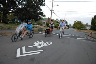
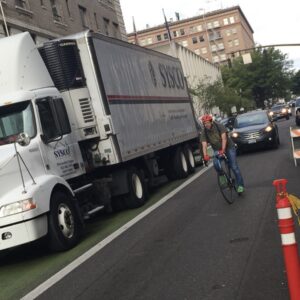
(Photo © J. Maus/BikePortland)
Update: See below for a few other examples of graphics that try to answer this question.
There’s an interesting, useful bit of transportation wonkery in The Bicycle Transportation Alliance’s “Blueprint for World-Class Cycling” that came out this week: a visual guide to which sort of streets should get which sort of bike infrastructure.
This is obviously a complicated question, and it’s not something that’s ever going to be summarized by a single chart. But the question arises constantly. Last week, in a moment of heat, two Swan Island transportation advocates said the city would be better off without bike lanes near a crash-prone intersection of Interstate Avenue. Up in Vancouver, Wash., there’s a lively debate right now about whether sharrows are appropriate on a 35 mph four-lane street.
Here’s what the BTA’s new document has to say about the issue:
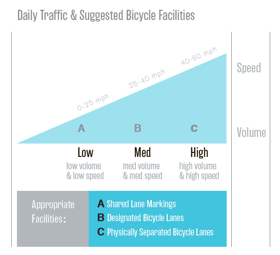
As BTA communications manager Will Vanlue said in a conversation this week, this isn’t the easiest graphic in the world to immediately grasp: as he observed, it’s trying to express three variables in two dimensions. But it’s a clearer expression than anything I’ve seen before of the principle that there are essentially three kinds of bikeable streets in a city, and making them bike-friendly requires a different category of infrastructure for each.
Like I said, the question of when exactly to use which facilities is very much a live debate, and I’m sure the BTA would say that case-by-case decisions are often required. But in a world where most people still haven’t thought about bike infrastructure in any systematic way, this graphic might be a useful way to outline the general consensus.
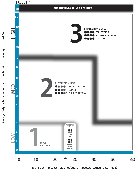
Update: Great to hear from a few other data-visualization nerds out there. Here are some more examples linked to by commenters below. First, from Allan and Washington County’s new Bicycle Design Facility Toolkit:
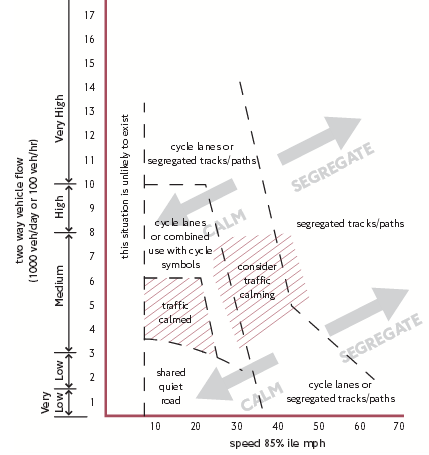
Second, from RJ and Transport for London:
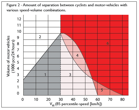
Third, from Rithy Khut and what seems to be an unidentified textbook he’s used for a class about biking in Amsterdam:
Fourth, from Chris Anderson and Copenhagenize, is one that I’ll link to rather than embedding, since it’s presumably Copenhagenize intellectual property.
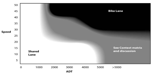
Also, the BTA’s Vanlue mentioned this chart used by the Oregon Department of Transportation. (You can also see ODOT’s “Context matrix” here (PDF).)
Each graphic definitely has its ups and downs.



Thanks for reading.
BikePortland has served this community with independent community journalism since 2005. We rely on subscriptions from readers like you to survive. Your financial support is vital in keeping this valuable resource alive and well.
Please subscribe today to strengthen and expand our work.
this is what Washington county just adopted:
http://www.co.washington.or.us/LUT/Divisions/CPM/bike-facility-design-toolkit.cfm
I think its a bit better than the one graphic you posted. I hope other jurisdictions in Oregon pick a similar metric. The one thing i will say is ‘buffered’ bike lanes at 5′ + 2′ buffer aren’t that great
Thanks, Allan! Looks like the most similar chart to this one is on page 13 of that document. Is that right?
That Washington County chart is way better in my opinion. The BTA chart leaves open the question of what is “high volume.” If you decide that few roads are “high volume,” the BTA chart could lead you to believe that most arterials in Portland just need five-foot door-zone bike lanes, which I *hope* the BTA doesn’t believe….
I agree. The BTA chart is overly simplistic, offering no guidance as to appropriate facility type on high traffic/lower speed streets (downtown portland) or lower traffic/higher speed streets (outer East portland). Plus, as Alex notes, what constitutes high/low volume?
“The one thing i will say is ‘buffered’ bike lanes at 5′ + 2′ buffer aren’t that great”
Care to explain why you think a well-connected network of 7’+ bike lanes is not a good idea? The growth of cycling in Portland certainly argues that bike lanes can lead to increases in mode share. Its a pity that PBOT stopped expanding and improving sub-par 4-5 foot bike lanes for ideological reasons. Moreover, the explosive growth of cycling in Germany during a period where physically separated lanes were replaced with buffered bike lanes suggests that the same can happen here.
Cycle tracks protected by parking are dangerous facilities that create new conflict at intersections by minimizing cyclist visibility. Cully and Broadway (in PDX) are good examples of this. If a separated facility is needed, ramped or flushed curbs are a far safer design.
Well you said it yourself, it’s not the cycle track, it’s the intersection design. You have to redesign the intersection to make them work properly.
“You have to redesign the intersection to make them work properly.”
Or you could just install a cheaper and safer facility that has been linked to stunning increases in mode share in europe.
I’m with you that they’re much more safe, but moving or making a new curb is not in anyway cheaper than the paint it usually requires to make a carpark buffer cycletrack.
sorry for not being clear, i was referring to buffered bike lanes.
raised bikelanes and ped crossings at minor intersections, clear the parking near major intersections.
What about those 5+ lane intersections in the Burbs? Ala Murray Blvd and Tualatin Valley Highway?
Traffic has 45 mph speed limit, poor visibility when turning. I think there needs to be a green bike lane that circumnavigates those types of intersection, with separate bike signals, and separated bike ROW that parallels those highways (they sure as heck aren’t “streets”). Good street lighting would help that illuminates the crosswalk/bikewalk.
Good intersection design will be much tougher in Portland, as the intersections are so much closer together with a narrower ROW that it is just so much more expensive to retrofit them.
If they are in fact going by this chart, then it seems likely the lively debate will continue. As well it should.
I thought I had kinda figured out where the “sharrows” made sense- “greenways”, etc- and then they went in on the St. John’s bridge, and I’ve been confused ever since.
Seems like if sharrows go in, speed limits should be reduced.
I was nearly clobbered on a rural road in Washington County last week (Scotch Church) when a car coming the opposite direction passed another car and took up the car lane in my direction of travel. They went by my elbow in the opposite direction at 60mph. The wind caused by the car and the terror of the situation forced me off into the ditch. This is a 55mph road with a passing line in the middle, and no shoulder on the road in either direction, just a white stripe and a few inches of spare pavement on the side.
Cars passing here are not looking for cyclists, who they assume are riding on the (nonexistent) shoulder. Am I right in suggesting the dotted line on this road be changed to a double stripe, until such time that a shoulder is added here? The response I received was that this road design falls within Federal guidelines, so it’s okay as is.
This is what the road looks like there. https://maps.google.com/?ll=45.573227,-122.977374&spn=0.012602,0.01929&t=h&layer=c&cbll=45.57322,-122.977197&panoid=z3xUwpHjtS3G5Y1-Ih334g&cbp=12,92.78,,0,4.32&z=16
You can imagine how it looks when both lanes have a car in them going the opposite direction. Check out the ‘bike facilities’. It’s that 3-inch strip on the right.
Seems like shoulders would be the way to go – a good 3′ shoulder (minimum) would really help on those rural highways. 4-5′ would be awesome… or else just add a new rural cyclepath like they have between Monmouth and Rickreall along 99W:
http://goo.gl/maps/WGXIL
Can’t believe they built that thing decades ago, but never expanded them into places where they could be useful for transportation purposes.
Dan,… As I can’t make my slow computer see the links you posted, I have to assume that since you described the are as “rural” is in fact just that.
Not to dismiss the incident that brought of you grief,(I am sure it was certainly scary) but we are more than likely eons away from any added infrastructure across the country, that remotely resembles re-shouldering all two lane blacktops.
I have yet to ride much in N.W. Washington county,( I hear lots of it is awesome!) but if it is like any other county road U.S.A., I imagine the most we could hope for would be speed controls in the way of signage, and tons of road user education.
Glad you were not hurt, and keep your eyes and ears open for the impatient ones out there.
Oh, and I think Washington Park would be a nice place for sharrows. Many times throughout the day there are more bikes than cars anyway.
That BTA graphic is rather incomplete – it should be square with two axes – Volume and Speed.
For example, it does a completely inadequate job representing the downtown streets, which are high volume but low speed.
I would argue that sharrows are sufficient on downtown streets where speeds are slow even though volumes are high.
Yes, with congestion there is lower speed differential …
not just congestion, but signal timing as well.
Sharrows would also be useful on current streets that have a high volume of bike traffic but absolutely no infrastructure. 20th and 28th, for example, should have sharrows and “bikes can use full lane” signs. Commercial streets like Alberta, Mississippi, upper Belmont, Hawthorne and lower division also get a lot of bike traffic and would benefit from sharrows.
Its sad that PBOT turned a potentially useful tool into a wayfinding signal.
One issue missing (or assumed) in most of this type of graph is that the bicyclist is travelling at a typical bike speed (~10 to 12 mph) on a near level roadway and thus the speed differential (difference in speed between the bike & motorised traffic) is a measure of the problem…but in cases where you have a steep hill (like Interstate) you may have bicyclists travelling as fast or faster than motorized traffic. [The uphill facilities have the opposite problem…cyclists may be travelling as slow as a pedestrian and less stable (needing a wider track).]
This one of the problems at hand along this portion of Interstate thru Albina…an often substandard bike lane (effected by narrowness and catch basins), with fast bike and car traffic, high percentage of HGVs (freight), drivers right hooking, drivers tailgating, etc….it is often worrisome about falling and the tailgating driver behind a cyclist not having enough time to react and avoid running over a cyclist. This is why you see a higher percentage of cyclists taking the lane going downhill here.
“One issue missing (or assumed) in most of this type of graph is that the bicyclist is travelling at a typical bike speed (~10 to 12 mph) on a near level roadway and thus the speed differential (difference in speed between the bike & motorised traffic) is a measure of the problem”
This is the nuance that is left out of most all charts of this kind: bike speed is not mentioned anywhere. The speed factor that goes into the kind of decision-making this and other charts of its kind purport to help with should be stated in terms of average difference between bike and auto speeds. A street on a hill would have two different “scores”–one for the uphill direction and one for the downhill. Interstate might have an average speed differential of +5mph in the downhill direction (auto speed – bike speed) and +25 in the uphill direction. That’s a big difference that might suggest different facility types for each side of the road.
And I agree – I love the work that Washington County has recently accomplished with their Bicycle Facility Design Toolkit. 😉
http://www.co.washington.or.us/LUT/Divisions/CPM/upload/Final-Toolkit.pdf
I like this graphic. Though simplistic, I think it gets most things right. People should be separated on high speed roads (as they usually prove to be the most dangerous if you get hit).
This graphic is interesting considering the debate about Foster. By this graphic, Foster would be sufficient with bike lanes, and doesn’t necessarily require separated bike facilities.
“Foster would be sufficient with bike lanes, and doesn’t necessarily require separated bike facilities.”
exactly!
Unless Foster is high volume, which according to the Washington County guidelines it would be….
The volume is still not as important for me as the speed. Look at downtown, most places you can take the lane and be okay due to the slow (15-20mph in most places) speed, even though it’s high volume.
The call for physical-separation on low speed streets makes absolutely no sense. Why does a 15 mph zone like downtown PDX need physical separation?
As Jan Heine noted, physical separation has been linked to an increase in risk on low speed streets.
http://janheine.files.wordpress.com/2013/05/table_antwerp.jpg?w=640&h=149
http://janheine.wordpress.com/2013/05/28/bike-to-work-4-best-of-all-worlds-together/#comments
The original study from Antwerp:
http://www.verkeerskunde.be/sites/default/files/675_eindrapport_fietsongevallen_pz-antwerpen__16_september_2011.pdf
I think you might be reading the chart wrong, or you just didn’t mean to reply to me directly.
Sorry this site continuously messes comment nesting.
Did you actually read the study you linked to? Or did you just look at some out of context charts. It doesn’t say what you seem to think it says.
A big point is that the study did not compare accident rates to bike traffic volume. Which is why roads with no bike infrastructure actually get low numbers of accidents, they also have much more limited bike traffic. When looking at those charts you have to take that into account.
Second, no where does that study suggest that a high volume, low speed street should be treated the same as a low volume low speed street. In fact it suggest that speed matters much less than the type of street, for example residential streets even those with higher speeds were generaly safe with mixed traffic, whereas high traffic arterials were the most dangerous, even at lower speeds.
Notable for downtown, that study found that bike lanes were the most dangerous for areas with traffic lights. Full separation, or no bike facilities works out better in those areas.
Also when referencing that study to attack separated paths you should note the little part that says accident rates dropped a great deal for sufficiently bent paths (dutch intersections). So when criticizing separated paths, again, it’s not the path it’s the lack of a proper intersection design, and it is relatively easy to do right.
“A big point is that the study did not compare accident rates to bike traffic volume. ”
So you are arguing that a cycle track on a 10-20 mph street would be likely to have greater traffic volume than one on a 30 mph speed arterial/collecter?
Really???
And the rest of your comments are strawmen. Firstly, I made no claim that bike lanes are safer in low speed areas. The study suggested that on low speed streets, no infrastructure is safest. Secondly, I never denied that dutch-style treatments would not be safer than no treatments. The real question is whether cycle tracks are safer than traffic calmed streets or car-light streets. I also find your comment that dutch intersection controls are inexpensive to be kind of ridiculous. And besides, limitation of car traffic is far cheaper than pouring new pavement.
You may want to look up what a straw man argument is, unless the irony is deliberate.
At any rate, no that’s not what I’m saying, I’m making no assertions about potential volume. I’m saying that the Antwerp study did not look at the amount of bicycle traffic on any of the roads, it just looked at a database of reported accidents and attempted to parse that to show what types of roads and where on those roads those accidents were occurring. As such you can’t reasonably make conclusions from that study that having no infrastructure is safer, since it is reasonable to assume (and backed up by other more comprehensive studies) that adding infrastructure dramatically increases the amount of bicycle traffic. What the Antwerp study is good for is looking at what areas need special attention for safety, such as intersections when there are cycle tracks, and roads that have heavy freight traffic on them.
That said, other studies (for example: http://www.vehicularcyclist.com/copenhagen1.pdf ) have backed up the idea that cycle tracks can increase the number of accidents. This has resulted in better design standards and best practices that have significantly lowered those accident rates over the years. Though it could be argued that in the US we’re repeating most of the same mistakes made in Denmark and we don’t have the excuse of not knowing better.
Yes, on low speed, low volume roads, such as residential streets, mixed traffic is best. I know of basically no one that disagrees with that. I don’t know why that is even a question. It’s not what I’m talking about.
Lower speed, high volume streets, such as many of the ones downtown, are another story though. The Antwerp study suggests that this type of street is actually the most dangerous no matter what type of infrastructure you have, even more so than high speed streets (most likely because high speed streets tend to have fewer intersections which is a major conflict point).
There’s little evidence from the Antwerp study, or any other that I’ve seen, that mixed traffic is actually safer on this type of street, particularly combined with the fact that when no bike infrastructure is present we see very low amounts of bicycle traffic on these streets. People simply avoid them, or choose not to bicycle at all if their route is going to require them to ride on one. So, as an advocate of bicycling, not having infrastructure on these streets is not really an acceptable solution to me. Creating cycle tracks, and ideally doing them correctly to minimize the safety risk, is my preferred solution.
You state “the real question is whether cycle tracks are safer than traffic calmed streets or car-light streets.” I see that as an irrelevant question. Ideally whenever possible we should be creating traffic calmed streets and car-light streets, however such streets are not always along the route you want to go, and being able to travel relatively safely where you need to go is key to a transportation system.
Your statement that “limitation of car traffic is far cheaper than pouring new pavement” is also not true when looking at high traffic arterials, like many of the streets downtown, reducing the volume of traffic on these streets is difficult and expensive. Certainly it is more difficult to propose politically than simply re-pouring some curbs regardless of the actual cost for either. Never mind that these are also important streets for freight, and changing the traffic on them may have wide reaching negative economic impact. Also, I don’t think that I said they were inexpensive, just that they are relatively easy to do. They’re not as expensive as many try and make them out to be though.
A straw man is a misrepresentation of another person’s position.
a) You suggested that I purposely ignored data on bike lanes. For the record, I have always felt that bike lanes without infrastructure treatments are equally problematic when speeds are low.
b) You suggested that I was arguing against separated infrastructure, in general. I have always supported the use of separated paths when there is a high-speed differential.
**********************************************************************
“accident rates dropped a great deal for sufficiently bent paths”
You did not provide a direct quotation here. I can’t find this data in the tables or text.
“that adding infrastructure dramatically increases the amount of bicycle traffic”
So you are arguing that infrastructure dramatically increases the amount of bike traffic on low speed roads but not on moderate and high speed roads where the results were completely different? Interestingly, the “before and after” studies by Soren Jensen and colleagues reported increases in accident rates on cycle tracks before and after adjustment for traffic volume. Evidently traffic volume is not such a confounding factor, after all.
“This has resulted in better design standards and best practices that have significantly lowered those accident rates over the years.”
Citation please. Interestingly, a recent study by the ASDF suggested that Dutch cycle paths (like German cycle paths) are associated with a significant increase in hospitalization-assocated accidents.
“…such as many of the ones downtown, are another story though. The Antwerp study suggests that this type of street is actually the most dangerous”
A story that is unsupported by the Antwerp study.
“…particularly combined with the fact that when no bike infrastructure is present we see very low amounts of bicycle traffic on these streets. People simply avoid them, or choose not to bicycle at all if their route is going to require them to ride on one.”
And yet downtown PDX is full of cyclists commuting on streets with no infrastructure.
“not having infrastructure on these streets is not really an acceptable solution to me. Creating cycle tracks, and ideally doing them correctly to minimize the safety risk, is my preferred solution.”
The fact that poorer areas of PDX are completely disconnected from our fancy inner city bike infrastructure is unacceptable to me. I would support building cycle tracks on 15 mph streets after we achieve a little cycling infrastructure equity and connectivity.
“Ideally whenever possible we should be creating traffic calmed streets and car-light streets.”
I agree.
“…these are also important streets for freight, and changing the traffic on them may have wide reaching negative economic impact.”
Calming a few of downtown streets is not like putting Highway 26 on a road diet.
“They’re not as expensive as many try and make them out to be though.”
Many, if not most cycle tracks in Denmark still have uncontrolled intersections. Moreover, the cost of intersection improvement was one of the main reasons that Munich has been decommissioning its extensive network of cycle tracks.
For the sake of just public articles, I actually like the BTA chart better (and this is a rare “I like the BTA” quote so take a picture, it will last longer!) – I think the WA Co. chart is definitely much more comprehensive if I were sitting down trying to figure out city design plans with people that don’t know anything about infrastructure – so you want to make it simple, but not TOO simple to make city employees feel like high schoolers. Regardless, I could look at the BTA chart for half a second and immediately go, “Yup that exactly makes my point that the police officer was a dumb broad for saying we should have sharrows and ‘take the lane’ on Interstate during rush hour.” Whereas I had to stare at the WA Co. one for a second longer. I knew it was there, but I had to actually connect the dots a moment longer.
“we should have sharrows and ‘take the lane’ on Interstate during rush hour”
perhaps dumb in the uphill direction, where a slow ‘climbing lane’ for cyclists is appropriate; but not dumb in the downhill direction, where you are moving much faster on a bike and more room is required for maneuverability, and maneuverability is more important for safety.
until you get bowled down and honked at by every single driver coming at you from behind. I would rather have a separate lane – especially when I am hauling a trailer down Interstate (which I used to do every Saturday to go across the Broadway Bridge).
I’m not going 30 mph on my bike when I’m hauling cargo on my bike trailer. And I can tell you that rarely are any of the drivers. I’d like a radar gun out there because that’s definitely a high speed downhill.
…its all about me.
smile and wave
There are alternative routes.
If you control the lane and are in front of other traffic, you have the right of way regardless of speed differential, and being rear-ended is one of the lowest frequency types motorist-cyclist crashes.
Transport for London has a good diagram for this as well. Page 63.
http://www.tfl.gov.uk/assets/downloads/businessandpartners/lcds_chapter4.pdf
I prefer this one taken from a report I read.
http://wp.me/a1yhfM-28
This chart is missing an important variable: frequency of intersections. That’s where the real problems are.
Absolutely. Separated facilities actually increase risk when there are frequent intersections.
Dave, can you please support this with links to research? Thanks!
My links did not nest properly. They ended up above.
I posted 4 links but my comment was placed under moderation and has not appeared. If you read Jan Heine’s recent blog posts on infrastructure you can find links to Danish and German studies.
Interesting – thanks! I’ve never read the European cycle track skeptic (or relative skeptic) point of view.
By this criteria, Intersate Avenue or at least parts of it would earn a separated bikeway. That sounds good to me, but in the meantime how about a bikelane AND sharrows on that downhill section where cycylists can maintain something close to legal speed?
Intersections and narrow stretches of roadway are the real challenge. Visibility and reducing overall motor vehicle speed should be guiding principles.
Copenhagenize did one that is simple to read but with a little more nuance: http://www.copenhagenize.com/2013/04/the-copenhagenize-bicycle-planning-guide.html?m=1
Would love to see some separated (not just buffered) cycle tracks out in Washco – Beaverton & Hillsboro along major arterials. Some of them have 45+ mph speed limits – the # of people who feel safe cycling or walking along those streets inches from traffic must be microscopically low.
And how many car/bike crashes can you point to on those streets, NOT at intersections? That is the vanishingly small number.
All the graphs presented here seem to take account of the traffic volume and speed of motor vehicles alone. On the other hand, the Dutch design manual published by CROW takes account of the traffic volume of bicycles as well. This is a more rational method, I think.
http://www.crow.nl/nl/Publicaties/publicatiedetail?code=REC25
bicycles
Its amazing I’m still alive, somehow I’ve managed to ride to work and back for seven years, do 30 to 80 miles per week, sharing roads where traffic goes up to 70 mph, with no facilities at all.
Perhaps in the name of safety I should stop cycling, and write to my politician demanding more facilities before I even consider looking at my bike. In the mean time I shall drive to the gym to sit on a spin cycle for 1:20 mins a day.
Please stop pretending to represent cyclists interests.
What strikes me with all of these charts is that we should have separate bicycle tracks along streets with fast traffic. Barbur is a good example. Cars are allowed 45 mph, frquently going at 55. There are no intersections between Miles and Hamilton. This screams for a separate bicycle track. Similar with Beaverton-Hillsdale Hwy. Also remember that speeds like that aren’t even allowed in European towns and cities. The upper limit is 50 kmh or 30 mph. You would only experience the speeds of Barbur outside cities or on completely separated (from pedestrian, bicyclists, housing and interesections) freeway-style roads.
Most sections of Barbur have few if any intersections; these could be appropriate for separated facilities with proper design. Highway 43 to Lake Oswego might be another location that would be appropriate for fully separated infrastructure for the same reason.
Most objections to separated infrastructure relate to facilities proposed for placement on the inner city street grid, where the main arterials have many and frequent intersections, driveways and turning maneuvers along them; in these cases separated facilities would most likely lead to increased safety issues at the intersections.
We have quite a lot of urban roads limited to 50mph in British cities, cycling along them, whilst not fantastically pleasant, is in my experience just a bit of a slog. You can control the lane and move between lanes quite easily with a little bit of care.
We also have motorways, on which bicycles are prohibited.
We have some old country roads, which have been ‘improved’ to the speed of motorways but are still technically just ‘roads’. These are quite unpleasant to ride on and generally avoided by cyclist. There are usually quite a lot other quieter road going in the same sort of direction so its not a big problem. There’s one big very busy fast road going into Cornwall where a separate, slow traffic only road would be handy.
whoa. is that not a triple negative? can’t quite not follow you here, spare.
A good place for sharrows? How about the drivers’ education manuals of every state in the nation so that people who don’t bike know how to behave around bicyclists positioning themselves accordingly…