can do much better.
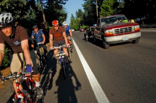
(Photo © J. Maus/BikePortland)
Next summer, the Oregon Department of Transportation (ODOT) will begin construction on a $5.5 million project to rebuild SE Powell Blvd between SE 111th and 174th. The plans call for a host of changes, including a new widened shoulder for bicycle access. How exactly that shoulder is used, and what type of bike facility ends up on it, will be one of the main topics up for discussion at an open house this Wednesday.
ODOT’s Outer Powell Safety Improvements Project has been in the planning stages for several years. The Portland Bureau of Transportation (PBOT) wrapped up a ‘Conceptual Design Plan’ over the summer and now ODOT (who has jurisdiction over the road because it’s State Highway 26) is zeroing in on the details. Among the improvements planned are new pavement, two crossing treatments to make it safer to cross on foot, new sidewalks, and more. ODOT says they also plan to conduct a speed study to consider a reduction in the posted speed limit.
According to ODOT, this section of Powell has eight intersections that are among the top 10% of high-crash locations in the entire region.
In their announcement of the upcoming open house, ODOT specifically says they are seeking community input on two “key aspects” of the project design: where to locate two new crosswalks with Rapid Flash Beacons; and how to “modify and better delineate the road shoulder and roadway striping to reduce conflicts between vehicles, pedestrians, and cyclists.”
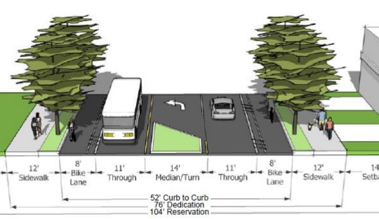
Currently, this stretch of Powell has some standard-width bike lanes which drop and then start-up again intermittently. PBOT’s plans call for an “enhanced bicycle facility” that would consist of a six-foot wide bike lane and a two-foot buffer for a total width of eight feet. This much space leaves open the possibility of not just a painted bike lane, but something more substantial — like a physically separated cycle track that could even be on a separate grade from auto traffic.
In their conceptual design plan, PBOT specifically noted that, “special attention [on SE Powell Blvd] needs to be given to… Facilities that separate the bicycle travel lane from the motor vehicle lane with striping or a physical barrier.”

We recently saw how a lack of public input on an ODOT project on NE Sandy Blvd resulted in inadequate bike access. This seems like a golden opportunity to inform ODOT about what’s possible and to vastly improve bike access on Powell.
Stay tuned, and consider stopping by the open house Wednesday night:
- Outer Powell Safety Improvements Project Open House
Wednesday, October 17 from 5pm to 7pm (drop by anytime)
Ron Russell Middle School Library (3955 SE 112th)
Project website


Thanks for reading.
BikePortland has served this community with independent community journalism since 2005. We rely on subscriptions from readers like you to survive. Your financial support is vital in keeping this valuable resource alive and well.
Please subscribe today to strengthen and expand our work.
Just reduce the speeds. Cheaper, quicker, and perhaps more effective at improving safety.
Maybe with all the money saved on other amendments they could extend the striping or speed limit reductions to parts of Powell further West that lack them.
This part cracked me up:
“According to ODOT, this section of Powell has eight intersections that are among the top 10% of high-crash locations in the entire region.
ODOT says they also plan to conduct a speed study to consider a reduction in the posted speed limit.”
…so it is recognized to be very dangerous, and they’re going to do X,Y, and Z, but only consider reducing the speed limit. What is the study going to reveal that we don’t already know?
Show me a study where speed is related to number of crashes (not severity). Good luck.
I will yield the balance of my time to the distinguished Greg Raisman on that question. If he is not aware of such a relationship then I withdraw my haughty comment.
I think what happened on holgate was pretty compelling. when they replaced a motor traffic lane with a bike lane, they effectively reduced the speed on holgate and dramatically reduced the crashes on holgate.
http://bikeportland.org/2011/05/12/pbot-data-buffered-bike-lanes-lead-to-big-safety-benefits-on-holgate-52885
I think what happened on holgate was pretty compelling. when they replaced a motor traffic lane with a bike lane, they effectively reduced the speed on holgate and dramatically reduced the crashes.
http://bikeportland.org/2011/05/12/pbot-data-buffered-bike-lanes-lead-to-big-safety-benefits-on-holgate-52885
World Health Organization latest study:
http://whqlibdoc.who.int/publications/2009/9789241563840_eng.pdf
I’d copy/paste but the PDF uses some weird font that is preventing me from doing so.
Thanks, Indy. Very useful study.
From the report:
“speed is a key risk factor for injury among pedestrians and cyclists.”
“An increase in average speed is directly related to both the likelihood of a crash occurring and to the severity of its consequences.”
“A 5% increases in average speed leads to an approximately 10% increase in crashes that cause injuries, and a 20% increase in fatal crashes.”
And here are the three studies from which those quotations were taken:
Nilsson G. Traffic safety dimension and the power model to describe the effect on speed safety Lund, Lund Institute of Technology, 2004.
Finch DJ et al. Speed, speed limits and accidents (Project Report 58) Crowthorne, Transport Research Laboratory, 1994.
Transport Research Centre. Speed management report. Paris, OECD Publishing, 2006.
I think the bike facility needs to be physically separated from auto traffic. the standard bike lane quickly becomes the resting place for gravel, debris, trash, etc. While I am all for reducing the speed limit, we all know people drive the speed they perceive to be safe, not the number on the sign. If they want to reduce the speed, they should start by making the lanes narrower and moving the bike lanes off the main surface. bike lanes often make the road look wider than it is, creating the feeling of a faster speed limit.
I agree with this. For Powell especially, there needs to be physical separation. However, the East West options are pretty well covered in the SE, what we really need is drama free ways to get across Powell going North or South. As it is, Powell is nearly freeway like in how it blocks flow of peds and bicyclists going North and South. As a personal preference, I would love to see a wholesale redo of the Powell 42nd/43rd intersection to make it far more bike friendly. This would be the perfect place to introduce Amsterdam style bike specific signals.
Nevermind on the 42nd/43rd suggestion. Didn’t realize that they are only looking at 111th and further east.
You are thinking of Inner SE. In Outer SE, where this project is located, Powell is the only E-W thru-route for a mile in either direction (near Powell butte, for example), and Division is the next route a mile to the north. Making Powell a comfortable, safe route is essential.
My experience riding in Germany where the streets are much, much narrower is that when cars are limited to 30km/h the bit of paint indicating a bike lane is more than adequate since the speed differential is so small. Cars and trucks and buses just wait to pass.
Why does Powell Blvd have to be so big/fast/ugly? Whose priorities does this reflect?
It is 2 lane with no shoulder out past 111th. Not exactly wide, but yes, not German either.
Because it is a state highway that kind of directly goes to mount hood. Think about 26 on the west side, now think about 26 (or powell) on the east side. Major differences.
it was supposed to be a freeway so they were trying to make it big, fast, and ugly…
yes!
plus I’m tired of the cars swerving into the bike lane to pass people waiting to turn left…
they need to physically separate them…
But with a turning lane in the middle, this would conceivably not be a problem anymore.
The access points to Division, especially where Fred Meyers (145th & 148th) need safer cross access, as does the stretch between 122nd and 136th. Long stretches between crossings as well as a wider roadbed encourage high speed traffic and frankly, to cross there is playing frogger with high speed traffic.
Outer East Portland needs a higher level of investment in facilities due to the recent annexation and the fact many low income folks have been ‘gentrified’ to East, with large distances to cover with minimal transit, the ‘linear shopping malls’ along large high speed streets.
If the cost of a car and transit are deal breakers, walking and biking are the options. When multi laned high volume streets are obstacles to taking care of daily needs, we darn well better get something workable in place.
The Bike Master Plan for 2030 recognized equity as an important facet to be considered, and East Portland needs a fair amount of equity ‘tout de suite’
It’s a Major City Traffic Street, Regional Transit Street and Major Truck Route (city designations), plus it’s a state highway, not under the control of the City. State law dictates that you cannot reduce the hole in the air for trucks, because someday they might want to take a large load down that path and the path is now 34-36 of clear road width. Reducing lane width below 11 ft is not advisable.
We still have to share the road.
I think route 26 should get changed to follow I-84 to 239th / 242nd. That route is faster than Powell anyway. Then if Powell were no longer State Route 26 then Portland and Gresham would have free rein to make it a more liveable, loveable street!
The best solution I would think could be moving the planting strip to in between the bike lane and the through lanes. You could keep the 11-12 foot travel lanes plus the 14 foot turning lane, but create a cycle track type wide shared sidewalk 12-14 foot wide on each side of the street.
There also needs to be marked crosswalks with center refuge islands/traffic lights or beacons at least every four-five blocks. Of course these should line up with the greenway/bikeway crossings outlined in the “East Portland in Motion” plan.
This stretch of road really does need modernization and we shou8ld be able to do a good job with proper planning.
Most of the planting strip is older pine trees that I think everyone would be loathe to move. Curious what they do about the busy busy intersections too. Maybe a chance to experiment with Dutch style separate phases for each mode?
sounds like a good idea as long as they kept the growth low to keep sight-lines at corners, and made lots of cut-throughs for all the house’s driveways…
but that would trap the cars and then emergency vehicles would have to use the bike lanes to get anywhere…
The plans show a short term and a long term alternatives. Instead of showing better ped and bike facilities in the long term, they show a wider roadbed, narrower sidewalks, and narrower bike lanes. So there we have it, folks. The long-term plan is to continue to accomodate as many cars as possible, at the expense of everyone else. Nice going ODOT.
The hope is that we never get to the ‘long term.’
The sooner the short term design is implemented the better. Once it’s on the ground, I doubt there will be the inertia to widen the road again.
Ever heard the adage, “Do it right, not fast.”
Doing it right the first time is ALWAYS worth it versus doing it fast.
According to the Concept plan the “long term alternative” is planned with High Capacity Transit in mind since this is the corridor targeted for another MAX line at some point in the future.
the areas that need most improvement are outside of the 111-174 segment. looks like they are working on the low hanging fruit. ..
the crossings at 122 & 136 are terrible, but dont really think the bike lanes are that bad, except …as mentioned , there are no ped xings between 122 & 136 and when a car stops to make a left, others swerve around it and into the bike area….
oh yeah, and bus’s cross the bike lane for pickup/dropoffs ..a TRIMET bus missed me by about 5 feet racing me to that spot ..got his number and reported that one. (for whatever good that does)
Improving this section of Powell is great, but what will perhaps help more is improving the connections elsewhere (because you have to leave Powell at some point if you’re going to travel west from this zone). From 182nd west, it would be faster and safer to take the Springwater if you can get to where you want: If you focus more on Foster Road improvements, you can get between 182nd and the new 50s bikeway taking Springwater and Foster instead of Powell. If that happens, it takes some of the pressure off Powell here and solves another huge problem.
God, YES!
Totally agree with Spiffy. I use Powell to get to work and could write >20 tickets in ten miles for motor vehicle bike lane incursions. Just look at how worn the wide, white “do not cross” bike lane stripe is. They don’t even slow down…
oh sure NOW they start considering improving this. my partner rides this after work and experience countless flats and close calls of right hooks. she left her job and doesnt ride Powell anymore. go figure.
I used to live out on Powell and 181st and commuted along it for about 18 months. My vote is a physically separated cycle track (switch the street trees and the bike lane to get the idea). Do that now and prevent it becoming a passing lane/turning lane/future road expansion. Can’t change the state designation due to the freight lobby having to sign off (they will never give up milage). “Hole in the air” will probably nix any safety improvements, but it’s worth a shot….
Heck YES. But only if it will ultimately connect to the river. And then can they do Hawthorne next plz??
We need elevated tracks. Then we could look down on all the motorists and be above the noxious gasses!