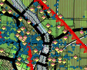
Blue dots are unreinforced masonry structures,
yellow diamonds are HAZMAT locations,
red line is a major fault.
The Portland Bureau of Emergency Management (PBEM) has released a series of maps showing where natural hazards exist in each neighborhood throughout the city. In the interest of being prepared if and when disaster strikes (having a cargo bike all ready to go will only get you so far), I thought it’d be fun to see how these known hazards line up with popular bike routes.
Here’s more about the maps from PBEM:
“The maps identify natural hazards throughout the city. They offer a neighborhood coalition by neighborhood coalition account of known earthquake faults, flood plains and other dangers, including hazardous material sites, steep slopes and forested areas at risk of fire. The maps also show community resources – such as evacuation routes and key transportation corridors used during emergencies, hospitals, county clinics, schools, fire stations and police facilities – within each neighborhood coalition area.”
I had no idea about the East Bank Fault that stretches from inner southeast all the way north. And wow, all those unreinforced masonry structures downtown. When the big one hits, I hope I’m working from home. Speaking of which, I live very close to the “Primary Evacuation Route” of I-5; but I have to say I can’t imagine that working out too well. I mean, I-5 can’t even handle rush-hour traffic on a normal weekday, so I don’t exactly see myself jumping in the mini-van and making a quick getaway when the shaking stops. Another thing that stood out for me are all the HAZMAT locations scattered around the city. Eeek.
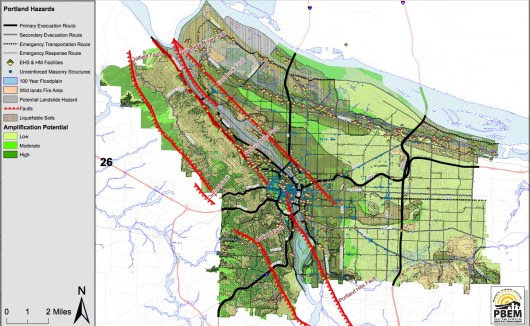
How about you? Are the places you ride going to be underwater, up in flames, oozing toxic chemicals, or buried in rubble when disaster strikes?
And if you’re into preparedness and cargo bikes, put the Disaster Relief Trials on your calendar for June 17th!
You can download the full citywide map, or a map specific to your neighborhood coalition from the Hazard Maps page on PBEM’s website




Thanks for reading.
BikePortland has served this community with independent community journalism since 2005. We rely on subscriptions from readers like you to survive. Your financial support is vital in keeping this valuable resource alive and well.
Please subscribe today to strengthen and expand our work.
So the East Bank fault runs right by the rear left corner of Legacy Manuel Hospital? Lovely.
It really wouldn’t matter. The hospital is almost completely unprepared for a disaster impacting the hundreds of thousands to millions of people surrounding it anyway.
I like how these are referred to as ‘natural hazards.’ I suppose that is meant ironically.
STOP! YOU ARE SCARING ME!
The airport seems safe enough….
I wonder how the Port of Portland got it excluded from the floodplain / liquefiable soils / mod-high ground acceleration classifications? It’s built on the same reclaimed swamp land as the area east of I-205 and west of NE 33rd, and all of these hazards exist there….
Anybody know how to identify which blue dots are which buildings? I couldn’t find a way to decode that. I live downtown and I’d really like to know where the piles of bricks are going to be.
zoom in to 200% and start counting lines from marked streets. I get 3 lines per block on the East Side.
Down town is not built on stable ground, expect damage even if your building is solid.
North of downtown there are all those oil tanks placed on fill, placed before earthquakes were considered to be an issue.
Our next big quake will be nothing like the quakes you are used to seeing in California. The next big quake, which is due anytime now according to its repetitive history will be like Japans big quake. The last time we had a big quake was jan 26 1700, it was between 8.7 and 9.2. It caused a landslide that dammed up the Columbia river at the “Bridge of the Gods”
I wouldn’t count on using ANY of the bridges across the Willamette. As far as I-5 for an evacuation route- It might get you as far as the next fallen overpass.
Bikes are probably going to be the only way to get around (and a boat to cross the river.
I recommend you have enough food and water stored to survive on your own for several weeks. along with necessary medicines, blankets, flashlights, cook stove…. you might not be able to return inside of your house.
This is just for natural disasters, some people are concerned about radicals setting of an EMP bomb that would take out all of our electronics. his would put us in an 1800’s situation except we are not geared to live without our modern conveniences, refrigeration, running water, heat, food trucks…..
I guess I’m starting to get off on a rant so I’ll stop now.
old chevies without electronic ignition would still run. You’d probably have to manually pump gas out of the storage tanks thougth.
or an old deisel rabbit with no computer or ignition
Other than an earthquake fault within a block of my house, everything looks just peachy.
Oh, good! Looks like my place is just outside of anything serious.
Except those faults are the little ones. The big one is going to suck until you’re well on the other side of the cascades.
Oh, sure. I am not saying my place is going to be totally safe. I just am not near any unreinforced structures or under something that is going to make my house blow up.
Let’s not forget the mini-nuclear pile at Reed College I keep hearing about.
Harmless for the most part. Its not big enough to melt down.
Small amounts can be dangerous, dirty bombs are a concern for a reason, but an earthquake would be a very unlikely way for it to be expelled into the atmosphere.
The only thing that I can see as a “Good” thing in all this, is that presuming we, people who ride bikes, survive the event, will be the only ones moving at speeds better than 5mph back to our homes/loved ones.
Oh, and don’t forget this people, a Disaster Preparedness Kit is a lot easier to build before you need it.
I’ve read a bit about the 1700 quake, but never heard about the Columbia damning up at the “Bridge of the Gods” Anyone have a link?
that map reminds me of the artwork for the MIA record
http://2.bp.blogspot.com/_NGeOXNeQU3k/TS9Zfs7mf-I/AAAAAAAAANU/SOPENNGvuE0/s1600/M.I.A.+-+Kala.jpg
I have read about it several times. Here is something I just googled, sort of interesting.
http://www.google.com/url?sa=t&rct=j&q=&esrc=s&frm=1&source=web&cd=7&ved=0CGwQFjAG&url=http%3A%2F%2Fcolumbiariverimages.com%2FRegions%2FPlaces%2Fbonneville_landslide.html&ei=Bza_T7uNH-TKiQL-scGWCA&usg=AFQjCNEKhkKjNROe8YAx0rT3CKhq-xEdhg&sig2=z5fT7H4288bZWAh3O2ZNfA
“In about 1450, an immense landslide tumbles off Table Mountain in Skamania County and completely blocks the Columbia River, shoving it a mile off course. A lake forms behind the dam extending as far as 100 miles. The river will eventually breach the dam causing a 100-foot-deep flood downstream and creating the Cascades rapids. This is the most recent of four documented slides in the 14-square-mile Cascade Landslide Complex and will be called the Bonneville Landslide.” — http://www.historylink.org/index.cfm?DisplayPage=output.cfm&file_id=7797
Doesn’t mention subduction zone seismic events.
Carbon dating from the trees that got buried in the lake put them at 1699, pretty close to the 1700 quake, hard to tell for sure though.
Hmm, yes, and more interesting factoids…
http://landslides.usgs.gov/recent/archives/1999bonneville.php (quoting an article in The Oregonian The Oregonian, 9/29/99, by Richard L. Hill, staff reporter):
Radiocarbon dates from the core of a Douglas fir buried 150 feet under the massive slide indicate it killed the fir about 400 years ago and perhaps as recently as 250 years ago. That would make the landslide half a millennium younger than a previous estimate, which said the slide occurred about A.D. 1100.
If future work supports the younger date, the slide would be in the same time frame as the last huge offshore earthquake, which rocked the Northwest coast in 1700. Although scientists are confident a quake caused the landslide, they say it’s premature to link it with the magnitude 9 earthquake.
From analyzing the radiocarbon dates, “my feeling is that the landslide likely happened between 1550 and 1750,” said Patrick T. Pringle, a geologist with the Washington Department of Natural Resources who has been conducting the study with Robert L. Schuster, a landslide expert with the U.S. Geological Survey. “I realize what a big window this is, but that’s about all the data allow us to say.”
It goes on to mention that tree ring analysis (dendrochronology) should help narrow the gap. Wonder what’s happened to that research since 1999?
Far more likely to get knocked off your bike AFTER such an emergency.
Bikes, (Especially bikes that can navigate the rubble), will instantly become invaluable.
Okay, well. I’m now keeping my bike helmet on ALWAYS.
Friends of mine live in Linnton, and they say the whole hill is supposed to slide in to the river. Good times!
Am I the only one who thinks it’s pointless to worry about stuff we can’t do anything about? Or am I just blase because I’ve been through a major earthquake (Alaska, 1964, 9.2)?
worrying doesn’t seem useful – I’d agree. But preparing, practicing, being strategic about what you have on hand when/if seems the antithesis of worrying to me, and much more useful.
Tell us about the 1964 Alaska earthquake.
What are good measures to take? I saw an emergency preparedness store on SE Glisan I think. What are ways to do this without spending a fortune?
Do have some water stored and non perishable food items, instant mashed potatoes are good for like 15 years, cup o noodles are 30 cents each, coffee, rice, canned tuna, dried beans… lots of these things are cheap and can keep your family alive when there is zero items at the store. LED lanterns can go for 100 hrs without changing batteries.
Strap your hot water heater to the wall so it doesn’t fall over, that will give you about 40-50 gallons of decent water (its a good idea to take a hose, attach it to the drain and flush the rust out of the water heater periodically)
Have a wrench handy in case you have to shut off your gas line (once its off don’t turn it on yourself, let the gas co. do that) Know where the water shut off valve is so your basement doesn’t flood.
Sometimes you can send a text when you can’t get a call through. Also have an emergency contact person outside of our area, sometimes you can make long distance calls but not local calls, also they might not be affected by what mess your in. That person outside of our area can relay information to other family members.
Ham radios will work when nothing else does, however you need a license from the fcc for them.
Older houses can be helped by bolting them to the foundation, newer houses are built that way already.
I’m just hoping the new Caruthers Bridge gets finished before the Big One hits, so I can actually get home if it happens while I’m at work.
By the way, the Earthquake Country Alliance in SoCal has put together a fantastic handbook for dealing with quake hazards. The 4 things they recommend doing BEFORE a quake hits:
1. Identify and fix potential hazards in your home.
2. Create a disaster plan.
3. Prepare disaster supplies kits.
4. Identify and begin to fix your building’s potential weaknesses.
A couple of excerpts from task #1: “Several people died and thousands were injured in the Northridge earthquake because of unsecured building contents such as toppling bookcases. Many billions of dollars were lost due to this type of damage” … “You should secure anything 1) heavy enough to hurt you if it falls on you, or 2) fragile and/or expensive enough to be a significant loss if it falls.”
In other words, the biggest danger is not your building but the stuff IN it and lack of preparedness. Reinforcing your building can be very expensive, while the basics don’t have to be: install cabinet locks (the babyproofing kind are fine) and bolt/strap stuff down; figure out your plan; and have emergency supplies at the ready.
When the big one hits, plan on taking a boat home.
There is a book out callede”One second after” that has to do with an EMP bomb.
http://www.google.com/url?sa=t&rct=j&q=one%20second%20after&source=web&cd=1&ved=0CHgQFjAA&url=http%3A%2F%2Fwww.onesecondafter.com%2F&ei=bRzBT_75OKGOiAKZ4fHvBw&usg=AFQjCNF2j7divf4Jrz6va7UIXPo8mrbePQ&sig2=TZ3LAgMRTMmoN60vvpHuhQ
Reading in that last link I posted there is a section where they talk about preparedness, In 1962 they had the last atmosheric nuclear blast, testing EMP they found even back then it damaged car ignition systems, before computers were in cars. You can protect sensitive components in a faraday cage