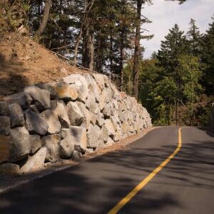
(Photo: Will Vanlue)
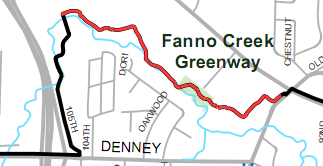
Last week we showed you a few pictures of the not-quite-finished section of the Fanno Creek Trail which connects the intersection of Scholls Ferry Road and Allen Blvd to the end of 105th Court near the intersection of Denney Road and Highway 217.
At the time there were a few details that needed to be finished on the trail and construction crews were asking people to stay clear of the trail.
Now that construction has finished, Tualatin Hills Park & Recreation District (THPRD) has officially opened the new section of trail.

(Full PDF map)
THPRD is hoping the new section will increase use of the north section of the Fanno Creek Trail.
Electronic counters estimate that approximately 70,000-80,000 people use the trail’s north segment each year, while counters on the southern section of the trail estimate that 120,000 people pass through the tunnel under Scholls Ferry Road.
“The Fanno Creek Trail is already very popular, and we expect it to be even more popular now that this new segment is finished,” said Hal Bergsma, THPRD’s director of Planning. “Until now, when trail users came to the missing link, they had to figure out on their own how to reconnect with the trail. Now, their path is mostly uninterrupted.”
Unfortunately the new paved section of the Fanno Creek Trail isn’t entirely continuous. As Bergsma said, the new section only provides a “mostly uninterrupted” connection between THPRD’s Garden Home Recreation Center and Tigard’s Englewood Park near Scholls Ferry Road.
One remaining section, near the City of Beaverton operations facility and Scholls Ferry Road, is only a gravel path. That section will remain unpaved until Washington County completes a bridge replacement and road widening project nearby.
More information can be found on THPRD’s website or by calling them at 503-645-6433.
We’ve heard that some readers have already ridden on the new section of trail. Are you one of them? Tell us what you think in the comments.
— Read more Washington County bike news here. Contact Will Vanlue, will [at] bikeportland.org with tips and feedback.


Thanks for reading.
BikePortland has served this community with independent community journalism since 2005. We rely on subscriptions from readers like you to survive. Your financial support is vital in keeping this valuable resource alive and well.
Please subscribe today to strengthen and expand our work.
It’s a great addition to the Fanno Creek trail, and I’m glad to see that I no longer have to go sneaking onto it.
Now, if only we could get a bike/ped/ADA bridge to cross over Hwy 217 to connect the two segments.
Here’s a link to the thread on the forums
http://bikeportland.org/forum/showthread.php?t=4035
And to those I took before it opened.
http://www.flickr.com/photos/ufobike/sets/72157627839234371/
Two days ago there was still an orange sign up above the west side of the trail calling the trail closed, but nothing posted along the trail and all seemed complete. The trail curves a lot initially entering from the west end, with lots of striped markings. Once that plays out, the route is more direct and a pleasure to ride.
There is a paved route heading north before the Operations Center, which appeared to provide an alternate exit before the unpaved portion. Did not go there, so I am unsure exactly where it goes.
Looking forward to riding this again once we get out of winter and the vegetation picks back up!
When you get to the end of the paved trail on the east side of the Operations Center you have the choice to go east and then north on the gravel section to the Scholls/Allen intersection, or you can cut north across the parking lot and turn right on the existing paved trail that runs along Allen, then follow that to Scholls/Allen. The later will require most people to dismount to cross the planter strip between the north end of the parking lot and the path.
Can anyone explain to me why a bike trail or MUP has to be curvy? I have seen a few of these the last few days in other cities. And it just seems like they have designated the path as a recreation option, but not a serious transportation one. Could you imagine if I-5 had a bunch of random curves in it so people could enjoy the drive more?
Yeah, the Fanno Creek trail is really a recreation trail. I use it to commute between Olson and Scholls Ferry because that section of Garden Home is just so bad. I am contending with the joggers, walkers, and worst of all, dog-walkers with the worlds longest leashes. My incridi-bell gets a workout here 🙂
I love the trail, and have done a lot of running on it, but I really wish that one mile section of Garden Home would get proper bike lanes. That’s really the last “missing link” in my route from SW Portland to North Hillsboro.
And it mostly follows the Creek.
These trails are designed to minimize the impact on natural features (including existing trees), as well as minimize the need for massive earthmoving and retaining walls.
These are primarily trails for recreation, not bike commute traffic.
Nothing to do with the current topic, but I just downloaded the Instructible that has your current avatar in it, the one about how to make a glow-in-the-dark bike. Did you write that one?
Nope… That wasn’t me… I use passive systems, not active. At this time, I feel that Retro-Reflective films have a better visibility than
(damn computer… posted before I was done… AGAIN)
self-illuminating paints. In the Blackberry ad, it’s a fair bet that they used a black light and paint that fluoresces in it. As such, it wouldn’t be as visible in normal nighttime riding situations.
With that said, I’d LOVE to try the stuff anyway in combination with my retro-reflective films, and see what kind of results *I* could get.
“Recreation.” That’s it, exactly. You know, and I know, that these facilities are not serious bicycle transportation corridors. Dog walkers with long leashes, joggers, people walking across the path, blind corners, awkward connections with streets that access the trails, and frequent closures for government construction projects are but a few of the problems with this type of facility.
Another problem is that the money which was used to provide these “improvements” could have instead been used to complete the streets nearby. “Complete” means sidewalks and bike lanes. As was pointed out above and elsewhere on bikeportland, Garden Home Road west of Oleson, and Denney Road itself, could be complete streets and fill in important gaps in the bike lane network. That would mean spending more money, and probably taking part of people’s property.
If that money ever does become available, there will be resistance from those property owners of the form, “you already have the Fanno Trail, why do you need to take part of my property?” The distinction that Fanno Creek Trail is a recreation corridor will be lost on those property owners. When those property owners complain to the Washington County Board, or the Beaverton City Council, do you think that those elected officials will carefully explain that Fanno Creek Trail is just a recreation corridor, and yes the city/county does have to take property along parallel streets? I don’t think so, either.
I see in the this week’s Valley Times article on the Fanno Creek Trail, http://www.beavertonvalleytimes.com/news/story.php?story_id=132632943319606800 that yet another closure of the trail is anticipated. From that article, “To fully incorporate feedback from trail users as well as accommodate a pending Tualatin Valley Water District water line project between Southwest 90th and 92nd avenues, the pruning project is temporarily on hold.” (Emphasis added.)