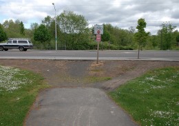
the Fanno Creek Trail meets a busy street,
mid-block crossings are key.
(Photo © J. Maus)
When you’re riding around Washington County, off-street trails and paths serve as an important alternative to wide arterial roads with freeway-speed traffic. The only trouble comes when a trail or path intersects a road mid-block, away from signalized intersections and marked crosswalks.
The County has recently installed three “mid-block crossings” — at West Union east of 185th, at Bethany Boulevard and St. Andrews, and on Cornell Road at Sunset High School — and a dozen more are planned for installation (both by Washington County and Tualatin Hills Park & Recreation District) in 2012.
Mid-block crossings have been taboo for years in Washington County. But times are changing. Shelley Oylear, Bicycle and Pedestrian Coordinator for Washington County, explained more to us via email:
“In the past, Washington County has approved pedestrian crossings only at road intersections with few exceptions. This was based on the belief that this was the only safe and practical system for drivers and pedestrians/bicyclists.”
Based on feedback from citizens and results from an engineering study, Oylear continued, the County now understands how important mid-block crossings are for the region’s transportation network (emphasis mine):
“The County recognizes the primary need expressed by bicyclists and pedestrians in Washington County is the need for a connected network, and those connections need to be safe and convenient. However, there are many existing and proposed trails and destinations that connect in the middle of blocks, between roadway intersections, and the ability to create crossings at these mid-block locations are an important step toward meeting the needs for safe, convenient connections.”
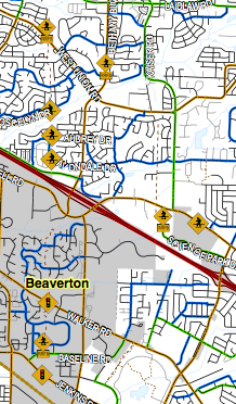
The crossings planned for 2012 are scattered around Beaverton and Hillsboro near Bethany Boulevard and Highway 26. You can have a look at all of the planned crossings in this PDF to see which ones will make your ride a little easier.
It’s a positive sign that Oylear and her colleagues in Washington County are embracing the notion that a safe, connected network is as important for traveling on foot and by bike as it is for traveling in a car. (There’s an argument to be made that it’s even more important for bicycle and pedestrian traffic.)
It will be interesting to see what additional crossings are planned and prioritized, now that mid-block crossings are recognized as a safe and viable option.
— For more on Washington County transportation news, check today’s edition of The Oregonian: Washington County has millions for transportation; debate turns to type of work: roads, walkways or bike paths?



Thanks for reading.
BikePortland has served this community with independent community journalism since 2005. We rely on subscriptions from readers like you to survive. Your financial support is vital in keeping this valuable resource alive and well.
Please subscribe today to strengthen and expand our work.
I wonder if this will inspire Wa Co to install a mid-block crossing of the Fanno Creek Trail– a major recreation and transportation corridor.
I sat in on several of the meetings about the Fanno Creek Trail/SW Hall Blvd crossing (the same one seen in Jonathan’s photo above). It was fairly well demonstrated that a Mid-Block crossing there won’t work. Expected growth of the region, and the already existing need for a 2nd left turn lane onto Greenway wouldn’t allow for a safe crossing that works.
The choices that ended up being recommended were those of a bridge that would ramp up and over the road (either with a straight shot, or a spiral), or a tunnel.
To meet ADA requirements, the ramps leading up to the bridge would need to be several hundred feet long on each side. Those ramps would be too long for a realistic wheelchairist to want to try, and only would probably be preferred by skateboarders.
The Tunnel option is the best option (IMHO), and I strongly pushed for it. It was the shortest solution that could be done, but it would be expensive.
Some very nice examples of tunnels were dug up (pun intended) by Wsbob.
http://bikeportland.org/forum/showthread.php?t=4043&page=2
More info at:
http://www.fannocrossinghall.org/
The only problem with a tunnel there is how close it is to Fanno Creek. I’d be willing to bet that it’s going to spend an awful lot of time flooded just like the tunnel under the MAX tracks on SW Schottky Trail (near the Milikan Way MAX stop.)
They finally got rid of that tunnel a few months ago. I’m surprised they ever put the thing in.
The plan is that the tunnel would be located away from the creek, so it wouldn’t have the issue of flooding every time the creek level rises a few inches. Unlike the Fanno Creek Trail/Scholls Ferry Road underpass.
“The only problem with a tunnel there is how close it is to Fanno Creek. I’d be willing to bet that it’s going to spend an awful lot of time flooded …” Rick Hamell
It’s a good idea to consider various heights reached by creek water during the cycle of the flood plain, and what frequency a tunnel, sited as best as possible to minimize flooding occurrences, might occasionally be flooded.
Fanno Creek Trail Park isn’t very wide (maybe a 1000′ wide at Hall?). The land rises some from the edge of the creek, but as the picture at the top of this story indirectly shows…not a lot.
Best to round up and take a look at the flood cycle data to get a better sense of what frequency of flooding a park tunnel at Hall might be subject to. To install a tunnel, Hall Blvd has to be elevated a bunch…a big,expensive project, emphasizing the importance of knowing how often the tunnel might be flooded. The water occasionally gets high at Hall/Fanno. Seem to vaguely remember some years back, the water getting close to the road grade
With luck though, flood cycles might allow the tunnel to built so it’s only flooded maybe once every 5 years…10 years..25 or 50 years…maybe longer.
Nice work, Shelley!
This is great news. I live near the Bethany area, so a lot of these crossings will be very helpful. I’m hoping that at some point, they’ll also consider lower speed limits and adding shoulders/bike lanes to streets in my area. It’s bad enough that I’d rather load my bike onto my car and take it somewhere else than ride out from my house. Still, these crossings are good news. I’m going to the meeting next Thursday to add my two cents to the mix, too.
As THPRD staff, developing trails that require mid-block crossings, I can add some info. I believe the Fanno Creek Trail will not get an at-grade mid-block at this time due to the traffic analysis. There is a study underway to evaluate the best solution, the website is http://www.fannocrossinghall.org/.
Next spring/summer we plan to connect Rock Creek Trail including a mid-block crossing on 185th south of West Union that will be fully-signalized, and another on Kaiser Rd. that will have a ped-activated flasher.
Thanks for that additional information, Patty!
I’d sure like to see one on SW Walker Rd between Murray and Cedar Hills.
Ditto, nice work Shelley and the other involved folks at WA CO and THPRD.
On a related note there’s a mark up meeting for future bike lanes/plans at Billy’s Bar on Dec 15th http://btaoregon.org/2011/11/washington-county-show-us-your-street-smarts-and-mark-up-big-maps-on-december-15th/).
Or an online link if you can’t make it:
http://www.co.washington.or.us/LUT/Divisions/LongRangePlanning/PlanningPrograms/TransportationPlanning/bikeandped/inventory-mapping.cfm
That is great. This is something that may save someones life, being able to cross safely. I hope they put some thought into these and do them right
This is wonderful news, and I plan to be at the Washington Co Mark Up Maps meeting on 12/15.