(See more below)
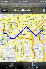
This morning I learned about a new iPhone app called Cycle Tracks. Created by the San Francisco County Transportation Authority, the app uses GPS to record bicycle trips, display maps of rides, and most importantly, logs all the information with transportation planners for use in evaluating current and future routes.
The app looks really sharp and the best part is that it can be used in any locale. We’ve already starting getting in touch with its developers and hopefully we can make this thing work in Portland.
For more, here’s what the San Francisco Chronicle said about it this morning:
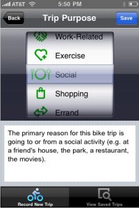
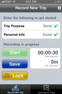
“Once bike riders install the app, they tap the “start recording” button, which begins tracking their trips and displaying them on a city map. When they’re done pedaling, they hit the “save” button, and the details of their journeys are sent to the authority, as well as saved in the user’s iPhone. The app uses GPS to track riders’ routes.
The authority plans to feed the data into the state-of-the-art computer model it uses to predict future traffic patterns. The goal is to figure out where bicyclists ride, why they choose those routes and how development decisions or transportation changes might affect them, said Billy Charlton, the authority’s deputy director for technology services.”
I’ve got it installed and I’m looking forward to using on my ride home tonight. We’ll keep you posted on a Portland-specific version. PBOT currently has no mechanism for capturing real data about trip types, distance and route characteristics and this app could prove to be an important source of information.
Here are a few more screenshots:
|
|
Learn more at the app’s official website and read more detailed coverage and discussion on Streetsblog SF.


Thanks for reading.
BikePortland has served this community with independent community journalism since 2005. We rely on subscriptions from readers like you to survive. Your financial support is vital in keeping this valuable resource alive and well.
Please subscribe today to strengthen and expand our work.
Does the iTouch have gps or does this only work with iPhones? If so, does the data only reflect a certain social/economic level of riders? Beside that, seems like a cool app.
There was a Streetsblog entry about this app before the Chron picked it up that discusses the possible socioeconomic imbalance. The general gist is that there’s so little data now that even biased data is good, as long as there is an awareness it may be biased.
Many gadget-loving cyclists (myself included) use one of the Garmin Edge-series bike computers. They work similarly to what is described above, by logging your route using GPS and allowing you to upload that to one of many web sites that can overlay the GPS data onto a map. Support for the Garmin Edge devices would be a big bonus if we do this here.
I have some Ruby on Rails web app experience and in fact recently have been experimenting with the Google Maps API for displaying GPS routes. I am interested in collaborating on open source web applications of this type. roadiescott at zenlinux dot com.
It “can be used in any locale” and you’re going to use it tonight, yet “hopefully we can make this thing work in Portland”? Kind of confusing…
Nick,
the GPS and mapping and other features will work in any locale… yet the data has nowhere to go. In other words, the SF County Transportation Authority has their databases linked up to the application so they can accept and use the data logged… however no such partnership exists in portland yet… so the data won’t be used anywhere.
Thanks for the clarification.
This sounds like something that could even be done in an open source manner by some interested/capable tech community people (count me in) if PBOT isn’t willing/able to get something set up.
I would love to see more collaboration between the bike/transit crowds and the open source/tech crowds here in Portland.
nick,
having the tech community step up wouldn’t really do much.. because the real value of this app is that the data is sent to a place that can use it to inform transportation planning decisions.
if the data only lives with the public than it’s just a fun toy… if it lives with PBOT/Multnomah County/Metro, etc… than we’ve really got something cool on our hands.
That makes sense. Fun toys are so distracting…
We already have this. And it’s not even iPhone-specific, and can work just as easily for bicycle routes as airline, transit or automotive routes!
OpenStreetMap solves all these use-case scenarios without taking ownership of your contributions, is global in scope, goes into an incredable level of detail where there’s many contributors, and is already live.
nice APP!
It is a special technology because it provides instant feedback/data submission- unfortunately with traditional GPS and other recording devices, the data often never makes it to those who could use it.
Unfortunately, as Alexis points out, this is an exclusive technology available only to those who choose to and can afford to own an iPhone and opt in to use this program. I’m sure the data this program collects will show plenty of trips to good business districts and yuppie neighborhoods, but it’s not accessible to record the trips of those who might not be able to afford an iPhone which could exclude whole residential districts; most kids don’t have iPhones so it wont be tracking trips to schools; and lots of people who ride bikes own other phones and wont be submitting their data.
The idea is cute. And it’s full of buzz words like “app,” “iPhone,” and “crowd sourcing” but until the program can collect data from a much wider range of input mechanisms it’s a totally skewed system with little real value for planning. Or San Fran can start putting iPhones in hands of randomly selected participants.
Agree with the previous comment. In addition, someone else may come along and provide a version for Android phones to make the potential user population larger but you’d still be stuck with the same economic prejudice or the prejudice of simply not owning a smartphone.
It is cool, though.
Does it do anything to calculate elevation changes, or plan routes to reduce elevation changes?
Android phones (new ones, anyway) can record GPS tracks. It should be simple to cause them to be uploaded.
http://searchengineland.com/google-my-tracks-uses-android-gps-to-capture-outdoor-performance-16551
JM (#7) — I think you are missing the implications of Nick’s point. There’s no reason the data should live only “with the public,” and there’s no reason the data should live only with PBOT/Metro/MC. If the data collection were done for PBOT/Metro/MC using open source software, then the public would truly benefit, as would the city planners. If it is done using a proprietary and overpriced software app that only works on an expensive toy, then no one else can do anything with the data and only Apple would benefit, at taxpayer expense.
Guys, it seems kind of silly to try to reinvent the wheel on this one… OpenStreetMap is already open source and works with a wide variety of GPS devices, or you can even go take it to a blueprint shop and get it plotted if you need a wall map or a glovebox map…
One volunteer even has a nice tile server for Garmin users that pulls the OpenStreetMap database about once every other week or so. There are other resources available for Android, iPhone, TomTom users, etc. with varying degrees of functionality and ease of use.
I’m working with Metro right now trying to get a snapshot of Bike There! data under a license that OSM can use, so the Portland region’s cyclemap can be filled in faster than the two or three volunteer bicycle mappers the city has can sort things out.
I foresee lots of bikelanes between downtown and lake oswego. It would be a terrible idea to actually use this data for planning. Maybe to direct actual, unbiased research to develop transportation plans, but there’s no way this should be considered a valid information source for a governing body.
FYI… CycleTracks is now available on the Android Platform as well – check it out on the Android Market.