BikePortland contributor Elly Blue shared an interesting website with me the other day. It’s called Walk Score and it calculates how walkable your neighborhood is based on your address and its proximity to grocery stores, parks, schools, and so on.
Elly’s a big fan of proximity, as you might remember from her article on it back in January.
Walk Score got me thinking about how trip distance relates to whether people choose to go by bike, walk, drive a car, or take transit.
During the recent Bicycle Master Plan public forums, PDOT asked people to share how they get around based on trips of various distances.
Below is the chart of results from that survey from a report by city bike coordinator Roger Geller (note that the vast majority of the nearly 200 respondents to the survey were avid cyclists):
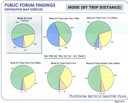
These results show that as trip distances increase, bicyclists in Portland tend to prefer driving a car over taking transit:
- For trips of 1-2 miles, 65% go by bike and 27% go by car.
- For trips greater than 4 miles, 49% go by bike, 46% go by car, and just 5% choose transit.
This result surprised Geller because common perception is that cyclists are transit users and therefore encouraging bike use does not necessarily remove cars from the road.
In the report he states,
“…when Portland cyclists aren’t bicycling, they’re driving. This leads to a conclusion that encouraging more bicycle trips does replace automobile trips and is an effective strategy to removing single-occupancy vehicles from the roadway as a means to address congestion.”
For me personally, I find public transit to be too slow and confining. Once you’ve mastered the city on two wheels, you can go pretty quickly anywhere, anytime. But that’s just me.
Here are some questions to think about…
- How walkable/bikeable is your neighborhood?
At what point do you ditch your bike and go by car?
Why do you prefer to drive a car rather than take transit?
And if you’d like to wonk out even more on trip distance and mode choice, here’s another set of stats from the Bike Master Plan meetings*.
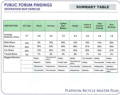
[*The interesting thing with this set of stats is that the biggest barrier to biking (even for avid cyclists) is a concern for safety.]





Thanks for reading.
BikePortland has served this community with independent community journalism since 2005. We rely on subscriptions from readers like you to survive. Your financial support is vital in keeping this valuable resource alive and well.
Please subscribe today to strengthen and expand our work.
I question how accurate the Walk Score thing is. I live at 29th and Alberta and my house scored 55, even though I am within 5 blocks of New Seasons, 4 bars, 2 coffee shops, and half a dozen restaurants. My dad lives in West Slope and has much fewer services in his area yet he scores 51. They even noted he\’s 4 miles from Cinema 21. (Are they thinking he\’s going to walk down Hwy 26 to see a movie?) My guess is they are not doing true routing over roads and paths, but rather using as-a-crow-flies distances. Maybe they should call it \”Fly Score\” instead.
More direct to Jonathan\’s question… I ditch my bike and drive when I have to go really far, e.g. it\’ll take a long time on the bus, or I have a lot to carry, or the dog is with me. Most places I go I can get faster on my bike than on the bus. Usually it\’s either the weather, a broken bike, or my girlfriend not having her bike with her that gets me on transit.
Before questioning every quirk of the program, read this:
http://www.walkscore.com/how-it-doesnt-work.shtml
The creators know its limitations, but I think it does a very impressive job.
Cool web site!
Yes too bad it does not include a bike score!
(Though I found out my old downtown worksite scores way better in walkability than my new suburban site: 82 vs. 56. No surprise there except how well the new site did…and that the program missed some pedestrian generators in its process.)
Before you run the program…make sure to give it time to finish scoring…as it might take a minute or so to crank out the data.
As for low scores on Alberta…perhaps those business do not have any presence on the web yet or a databank. Plus it might be looking at how broad a range of services are close by…vs. only bars and churches. 😉
I\’ll be the first to admit I didn\’t RTFM, but then I didn\’t read the manual for Google Maps or bycycle\’s TripPlanner, either, and I use them all the time. It\’s a good effort but would be much more useful if it applied the routing technologies that those websites do. (By the way, I work with transit and street mapping in my day job.)
Also, I just tried it again and it says \”we\’re over our Google Maps limit… try again in an hour\”. Have we created the \”BikePortland\” effect a la the Slashdot effect?
Personally I\’m among those that use transit when, for whatever reason, my bike doesn\’t seem like the best option. For the most part though I ride everywhere… I keep a few bus tickets with me just in case, but I rarely use them.
Before I ditched my car for good though, I did tend to use it as my best second option. Of course, I tended to do so under the silly impression that I would get where I was going faster by car. However any extra speed I gained was insignificant, considering I had to park further away than I could lock up my bike, and the extra walking distance ate my time gain, which was small to begin with.
I think it\’s interesting that the highest percentage of trips taken by bike for each trip type (work, groceries, coffee/bar, etc…) was for work, with 79%. I\’ve been thinking that the hardest trip to change is the trip to work for various reasons, but maybe I should rethink that.
But maybe that\’s more a reflection of the people who came to the forum – perhaps only we hard-core commuter types came, rather than the twice-a-week-to-the-bar types.
George Bush\’s ranch scores a zero! That\’s cool. My house scores fifty something, but for most of the businesses listed I\’d have to walk on water or risk a year in jail and a $6500 fine trespassing on the railroad bridge to get to Lake Oswego.
I bike to the bus and use the bus to avoid a big hill and getting too sweaty on the way to work then bike all the way home.
Well, I guess I\’m one of the few hybrid bike-transit users. I have a car, but I try to avoid using it as much as I can. I\’m also not hard-core and I live far-out in SE (10 miles from downtown; think Sellwood, but near SE 82nd).
A common pattern for a weekend for me is to bike the whole way downtown and spend the day biking around. On the way home I often bike to a major bus stop to take me most of the way, and then bike from the point I get off to home (2-4 miles). Or I may even bike the whole way home, it just depends how hungry for dinner I am. 😉
As a hybrid user, my bus choices are much more broad than if I were solely on foot. I may take the 9 Powell, 17 Holgate, 14 Hawthorne, 19 Woodstock or 10 Harold — usually whichever is closest and/or comes first. Or maybe I\’ll purposely take a far away bus or get off early if I want to get more biking in.
Living closer would be great, but for where I am I think the bike + bus mix works well.
Forgive me for I have sinned. I was an SOV… just today. It has been 3 months since I last drove to work. But it wasn’t my fault. Maybe we need a confession booth on the forum. Know what’s worse? I’m going to have to get gas. Aagh the anguished soul. It is my fault. I own a car. Maybe I should sing my ownself’s praise for being a dedicated bike commuter, but having just read excerpts from Al Gore’s ‘Assault on Reason’, I feel like I just undid weeks of goodness.
So I have to go out to bum frickin’ Estacada after work for a few hours. I was a little concerned about a midnight ride on steep no shoulder country roads with hairpin turns back to Gresham. I would love it except for the drunk guy in a Ford crew cab swiping me with his side mirror. Apparently my concern is safety and distance in this case.
I like to think about what is attainable by bike from my house and find that a 15 mile radius has become my range for a spontaneous destination or a 12-15 mile round trip for errands. Actually I like a 20-25 mile errand on a weekend day or an occasional 45-50 miles for leisure, but I digress. I might seek out a century tomorrow to absolve myself of today’s transgression.
I started with a 5-7 mile radius, then 10, and now with a new bike, 15. Fifteen miles takes a little more than an hour. Any more than that requires more planning such as scheduling to leave earlier, finding bus connections and, since it gets beyond the familiar, finding a good route.
Not knowing the route can be a problem. No matter how early I leave and how hard I study the map and bus routes, I’m racing around side streets trying to figure out a freeway crossing or a bridge approach to get to my destination five minutes late and sweaty. Once I learn the route a bike is the only way to get there. I actually like riding Trimet and kind of wish I used it more. But with my bike, I don’t need it often and may only use it 3 or 4 times a month. I have a perfect 10 mile one-way commute on a great route. I’d like to do more walking and running if somebody could pry me off my bike.
You already know some about my car issue. More confessions to come…
\”These results show that as trip distances increase, bicyclists in Portland tend to prefer driving a car over taking transit:\”
The data do not support that statement (they don\’t disprove it either). As trip distances increase, car use increases and both bike and transit use decrease.
\”For trips of 1-2 miles, 65% go by bike … For trips greater than 4 miles, 49% go by bike, 46% go by car, and just 5% choose transit. This result surprised Geller because common perception is that cyclists are transit users and therefore encouraging bike use does not necessarily remove cars from the road.\”
It\’s likely that cyclists switch to cars or transit in the same proportions that motorists do. The results don\’t surprise me because there\’s a huge disconnect between \”inner Portland\” cyclists and \”outer Portland\” cyclists. Beyond 4 miles is past 82nd Avenue. The results, IMO, change as much as they do because most inner NE and SE cyclists don\’t typically go more than 4 miles from their home or work – if they do, they probably \”need\” to use a car. Those who live that far out from the downtown core typically don\’t ride, and Tri-Met beyond 3 miles from downtown sucks for getting anywhere OTHER than downtown.
This is mostly anecdotal and based on \”reason\”, though, so I welcome conflicting opinions backed by actual data.
I believe that walk score is cool, but nowadays more and more people prefer to drive cars. Homes are often located in an area where some establishments are easier to get to by car than on foot. I\’ve recently found a type of service on drivescore.fizber.com which is called Drive Score. It shows a map of what establishments are in your neighborhood and calculates a Drive Score based on the number of places within a convenient driving distance. It doesn’t mean that drive score is better than walk score – they are equal and both necessary in the modern world!