to get up there before the cars and RVs return.
(Photo OregonDOT/Flickr)
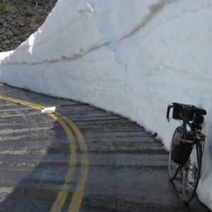
The Oregon Depart of Transportation announced this morning that the McKenzie Pass Highway (OR 242) is now open to biking and walking traffic only. This is an annual event that occurs just after ODOT snow plow crews clear one lane of the highway; but there’s still too much snow for safe motor vehicle traffic.
Here’s my favorite line from the official ODOT press release:
“ODOT urges those who access the highway to seize the opportunity to ride or walk the scenic route for the next few weeks. It’s important that all cyclists obey the normal rules of the road when they travel the highway.”
ODOT says they expect McKenzie Pass to remain carfree until at least early June. Last year it opened to motor vehicle traffic on June 19th.
The pass itself is 36 miles of some of the best riding in the entire Pacific Northwest. It’s so great that it’s officially designated as an Oregon State Scenic Bikeway. Here’s an excerpt from the ride description via RideOregonRide.com:
The official route starts in Sisters and heads west past hay meadows, ascending 2,000 feet through ponderosa pine forests. The road follows an 1860s wagon route, emerging from the forest at Windy Point and revealing a view of Mt. Washington and a 2,000-year-old lava flow. The 25-mile, 4,000 ft descent to Highway 126 snakes down exhilarating switchbacks to the dense, verdant Cascadian forests and rushes out over the McKenzie River. It’s these dramatic transitions through such diverse natural environments that define the uniqueness of this bikeway.
… I’ve been on this road in the spring when it was plowed just one lane wide, and I rode between 6-foot walls of snow, on bare pavement, like a bike-luge run.
I rode McKenzie Pass during Cycle Oregon 2007, but I’ve never done it “luge” style during this special closure period. I think it’s safe to say it’s worth getting up there if you can.
For more information, see the cue sheets and maps at RideOregonRide.com and the Scenic Bikeway website. There are also videos and more info via this Seattle PI blog post.


Thanks for reading.
BikePortland has served this community with independent community journalism since 2005. We rely on subscriptions from readers like you to survive. Your financial support is vital in keeping this valuable resource alive and well.
Please subscribe today to strengthen and expand our work.
How very nifty.
That ODOT writers just couldn’t pass up the chance of a paternalistic jab at cyclists is noted, however.
I’m a cyclist and I didn’t feel the jab. You seem to be doing the ODOT jabbing (no, i don’t work for ODOT). To me it just sounds like they’re asking everybody to be safe. Do people usually have to walk on eggshells when around you?
“To me it just sounds like they’re asking everybody to be safe.”
I appreciate that you hear it that way and imagine there are others who do as well. I’m just saying that I don’t. The implication in the passage Jonathan quoted is that cyclists wouldn’t. Hey kid’s, no horseplay o.k.? If my neighbor said that I’d be more inclined to let it slide, but ODOT should in my view be held to a higher standard.
Let’s imagine this were flipped and the group being addressed drove cars. Do you think ODOT would bother to tack on that little admonition about obeying rules? Of course not.
“Do people usually have to walk on eggshells when around you?”
ODOT isn’t people. ODOT is an public institution with a regrettable inability to take seriously or respect non-car modes (see recent Barbur Blvd flap for an example). I admit to being overly sensitive when it comes to their (or any other institution’s) communication on these subjects because I think all of this matters. It matters when it comes to a jury trial of someone who ran over someone on a bike. It matters when it comes to police judgments. It matters when it comes to newspaper coverage. The dozens or hundreds of little paternalistic jabs we encounter, that treat bikes and those who ride them as not quite grown up, as unequal, add up to something I would like us to move beyond.
Wow! You can read things between lines that don’t exist to me. That’s a talent I guess I don’t have. Oh, and thanks for letting me know that ODOT isn’t people/humans or made up of people/humans but rather (and I’m trying to read between your lines here) robots, excuse me, institutional robots out to get us cyclists, killing us slowly with little jabs over long periods of time. Swallowing saliva over a lifetime kills us too but now I don’t know which one is worse. Please read between the lines again and let me know if ODOT is responsible for clubbing all the baby seals, killing the whales and 911. Maybe I need a little more paranoia in my life to understand these things. Yep, that’s it. And some more eggshells.
Hi Getoverit and 9watts. Please be sensitive to each other’s perspectives.
Getoverit… I don’t appreciate the tone of your last comment directed to 9watts. 9watts comments here all the time and has a particular viewpoint that he takes time and care to explain when asked about it. His views are often hard for some people to fully understand and appreciate, but I think he maintains a respectful tone with other commenters.
And before both of you continue this back and forth, please consider the many people reading this who would rather have this thread focus on riding a very cool and carfree road.
Thanks.
Well now you sound paternalistic. 9 watts doesn’t appreciate paternalistic tones!!
I get where you are coming from. Personally I just read it as “We know that its closed to motorists, however be mindful that standard highway rules still apply as if cars were still present”. Perhaps it is not needed to most people, however there is always a faction of terribly stupid people who, after having caused major damage to life or limb will use the “I had no idea Highway rules applied when there’s no motor vehicle traffic” defense.
Sounds like an awesome ride.
Any chance Multnomah County would consider the same for Larch Mountain, is there? I love riding up in May to watch the snow line recede.
About how high up do you ride before you find snow this time of year? I’ve ridden up larch several times, but always in the middle of summer. I was thinking about heading up there soon and just going up until I find the snow/run out of road.
There’s a thread about it in the Bike Portland forums. Route Info – Larch Mountain… Almost
beautiful.
This is possibly the best ride in Oregon during this window. Spectacular views on clear days and riding through 10+foot high snow walls is a unique experience. East side is shorter/less climbing, west side has better pavement and more slightly gentler grade overall. Sisters has great spots for pre-, mid-, or post-ride meals, depending on which direction you go. Do it.
ODOT is right, people need to ride right of the centerline, otherwise there is potential for high speed uphill/downhill crashes on blind corners. I’ve seen a few close calls.
This is an awesome ride. I took my 12 and 14 year olds up there last year and we all had a great time. There probably are no other rides like this one in Oregon. Warning, though, it can get really cold really fast. Last year on Memorial day we sweated our way up to the top in shorts. By the time we coasted back down, we needed all our raingear just to stay warm. We’ll definitely do it again this year.
this is the year…
Excellent! I’ve ridden this from Sisters to Santiam Junction during the summer and it’s beautiful. I can’t wait to try it with the snow walls.
Is that road free of ice, or do they get frozen patches? That could get a little bit too much like a luge run.
I doubt I’ll be able to make it before the road opens to cars, but I definitely want to plan a car-free ride another year.
Can anyone tell me what the ride is like when cars are allowed to drive on it? From the photos I’ve seen I don’t see any shoulder at all. It looks like it would be pretty sketchy.
It’s a great ride any time, cars go slower and traffic volume very low, except maybe Sunday afternoons. No trucks allowed on the road, the largest are RVs, they also go slow. It’s a great fall ride, but beautiful anytime, don’t let the cars stop you.
This looks beautiful and I want to immediately return to the PNW and ride this. Alas, that will have to wait for a cross-country move. Is the snow this high for most/all of the route, so that the scenery is more above you then around you? Or does it vary? I’m just trying to wrap my head around 36 miles of riding between snow banks that high. . . .
This sounds fantastic. I wish I had the free time to do this, but alas…
Looking at all that snow I got this urge: get a little bmx bike, put on a Hannibal mask (for the snow) and a helmet (for safety); ride downhill and aim the bike towards the snow bank then plow face first in it while laughing and giggling. Repeat until exhaustion!
FYI- Crater Lake is another awesome ride this time of year. Much of it will be clear of snow. However, you need to watch out for rocks on the road. Also, a lot of downed trees. You may encounter snow at some point. It can be several miles or only a few hundred feet. Be smart, no one will be there to help you if anything goes wrong.
I’ll thank ODOT for giving the cyclists the consideration of using this wonderful road each year for a few weeks. I ride this pass several times before and after the gates swing open to auto traffic, I always enjoy the challenge and the beauty of the area. The road is such that cars go slower than highway speeds and trucks are prohibited (awful, paternalistic ODOT rules), so it’s is a great ride any time you ride it. Ride it car free, or when gates are open to all, it’s always a great Oregon ride.
So how do people ride this? Out and back from either the SIsters Side or Santiam side? Or is there a decent loop opportunity. As a loop, would it be 6000 of gain?
It depends on where you are coming from. People from Bend start in Sisters, people from the valley start on the McKenzie River side. I usually ride from McKenzie River, over the pass to Sisters for coffee or lunch, then go back over the pass and down to the start. The loop would involve Santiam Pass, doable, but not a pleasant ride at all. Much better to do an over and back ride. Over and back McKenzie to Sisters and back is about 75 miles.
The wall of snow is a short ~200 yard section near the summit at Dee Wright where the snow piles in to a small canyon in the lava rock. It is not typical of the ride, which is generally on clear dry roads. There are wet patches here and there on the west side in the trees but a more significant thing to watch out for is gravel and pine needles on the steep switchbacks descending to the west.
It is a truly special ride when closed to cars.
Can anyone tell me where the west side gates are?
I’m planning to ride up to the top and back down the same side. I think the west side is more scenic for such an experience, but I don’t recall where the gates are. My riding posse isn’t quite up for the 75 miles (and 10,000+ feet of elevation gain) of Jerryw’s up and back (wish we were that hardcore!).
Thanks.
The west side gate is 11 miles from the intersection of highway 126 and 242 (McKenzie Pass Road) There is little car traffic on 242 since the road is closed ahead, so start anywhere you’d like. There is a nice parking area at White Branch Youth Camp road. From there it’s 4 miles to the gate and 16 miles to the pass summit. A ride from White Branch to the summit and back is 32 miles and delightful!!!
I just rode McKenzie Pass today, from Sisters to a few miles beyond the pass and back. Absolutely one of the most fantastic road rides I have done. The weather was completely perfect, in the low 60s at the summit. Not surprisingly, after a few days of wet weather several dozen other cyclists had the same idea today.
By the way, there was some snow at the pass, but nothing like the massive wall shown in the photo above. On the other side of the pass there is one stretch of about a mile where there is continuous snow along the road, but it is only about a foot deep. I did have fun dragging my foot along the wall and spraying myself with snow while coasting alongside it.
It really is wonderful riding along a road that is surrounded by capital-w Wilderness on both sides and shared with NO cars (except a couple of vehicles with the friendly ODOT paint crew). The 2000′ climb from the west is challenging but not brutally steep, the scenery is some of the best anywhere, and descending at 30-35mph for 8 straight miles (and 20+mph all the way back to Sisters) made it worth every pedal stroke.
Next spring I’m coming back with camping gear and spending the night in this beautiful place.
Perhaps you could round up a small group ride, and play ride leader?
GlowBoy added some great details and here’s a few more. Depending on your ability and desire for length of ride, one can start anywhere along 126 such as the Ranger Station or on 242 like the Youth Camp ( no restrooms and no NW trail parking pass required), a trail head called Posey ….?, ( NW Trail PP is required and has restrooms). The last trailhead, name? Has parking, restrooms and is at the end of the road AKA, “The gate” to freedom from cars, minus a few random ODOT work crews. They smile a lot. I would too if that was my workplace!
From the gate up to the De Wight Observatory and Pass Summit (5320 ft.) is about 12 miles. The first 8 miles is solid climbing. It’s no cake walk. Averaged 6 to 8 mph speed but others may laugh at this climb and grind it out no problem. 3k to 4k elevation gain from Youth Camp. This side of the ride is more difficult vs. coming in from the Sisters side. But you get paid back for your efforts on the return trip if that’s your plan. I suggest 2 large water bottles minimum for the round trip from the Youth Camp to observatory and back. Camel back if you are doing more than that or use more than average. I ran out on the way back and had 2, 14oz bottles. We wished that we had brought our lunches that we left in the car. Cliff Bars and Gel packs didn’t cut it after the climb. There is a restroom at the observatory. Many use that as the turn around point for their ride back down the West side. The views of multiple Mountains are epic! To continue to Sisters, it’s about 1.5 hours for the average rider. West side gate to observatory took us about 2 hours with breaks. Only took about 35 minutes to get back to youth camp lot. (Check your break pads!) Also, note the orange cone by the gate. Important so you don’t slam into it at 30 mph upon your return. It’s a blind corner.
The drive there takes about 3 hours from PDX via Springfield. I suggest that route in the morning, then go home via Detroit in the afternoon. Hit the falls that are right off of 126 between 242 and 22 for a minute. Isahalli Falls? Sp? Then, hit “The Cedars” Bar and Restaurant in Detroit for a well deserved brew and burger. They have a Veggie burger and many salads on the menu. It’s an eclectic old place! Random stripper pole, big screen TV and hanging chain saws from the ceiling just like Paul Newman used in “Sometimes a Great Notion”. Impressive pictures on the wall of fallen Giants on log trucks. Have beer in hand to cry in while viewing!
This is an all day event for us Salem to PDX ish lowlanders but well worth it. I suggest buying your NW Trail PP prior unless you plan on saving a few bucks and parking at the Youth Camps large parking lot. Its right next to the first large gate that should be locked open. The Ranger Station may sell the passes. I didn’t see the honor boxes but may have missed them. This is now my favorite bike ride in Oregon. Well worth dedicating a day to do it. ODOT will reopen the road by June 16th this year. But it’s completely clear so I wouldn’t be surprised if they move up that date. Don’t dilly dally and enjoy!
Last chance (this year) to ride this car-free is Saturday during the Ride for Two Rivers. I hope to see you there http://www.nationalforests.org/ride