(Photos © J. Maus/BikePortland)
The Portland Bureau of Transportation (PBOT) is getting ready for the third year of the High Crash Corridor Program. The program (funded to the tune of $472,000 in this year’s budget), launched with a press conference in 2010 headlined by former Mayor Sam Adams, aims to tame traffic, educate the community, and improve safety on Portland’s large arterial streets.
It’s a well-worn truth among planners and advocates that a majority of fatal traffic collisions in our city occur on wide, high-volume, and/or high-speed streets known as arterials. PBOT data shows that just a small portion of the city’s 1,300 miles of arterials account for a majority of all collisions. 66% of Portland’s fatal collisions that involve someone walking and 52% of people who die in bicycle collisions occur on these streets. Despite the human toll, these arterials divide communities, prevent people from walking and biking, and have a host of other harmful impacts.
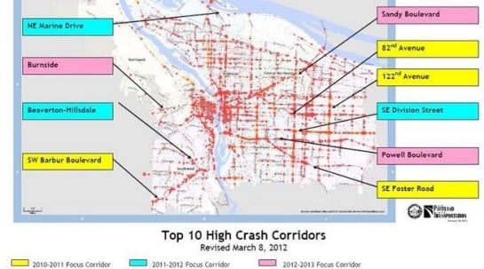
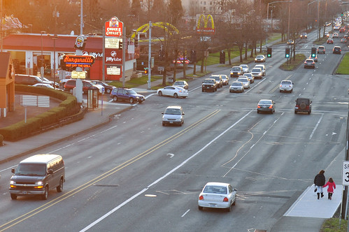
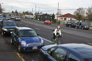
This year, PBOT has identified three streets to concentrate their safety efforts: W/E Burnside, SE Powell Blvd, and NE Sandy Blvd. These are just three of the top ten high crash corridors the agency identified when the effort launched in 2010. The others are: NE Marine Drive, Beaverton-Hillsdale Hwy, SW Barbur Blvd, 82nd Ave, 122nd Ave, SE Division, and SE Foster Rd. These streets have the highest serious crash rate per road mile and per mile traveled in the entire Portland metro region. With frequent transit service and lots of destinations, these streets also see a lot of street life (as we noted in a dispatch from SE Foster yesterday).
We reached out to PBOT’s High Crash Corridor program manager Clay Veka to learn more about what’s in store for the three 2013 focus corridors. She says they’ve already planned open houses for each of them:
- Sandy: 3/6/13, 6:30-8:30pm, Hollywood Senior Center
- Burnside: 2/27/13, 6:30-8:30pm, Buckman School Cafeteria
- Powell: targeting Summer 2013, location TBD
The effort will include a variety of activities that fall under the “three Es” of enforcement, engineering, and education. Veka says once they’ve done initial analysis and developed an existing conditions report, they’ll look implement “low-cost, rapid response engineering improvements” (that’s PBOT’s way of saying they have a very limited budget). These will be things like pavement markings, signage, changing signal timing, and so on.
PBOT assigns a “pedestrian educator” to work with the community through training sessions and other outreach activities. To tame auto traffic and to raise awareness about how to walk safely, PBOT will do enforcement actions in partnership with the police. They’ll also do little things like make sure ADA curb ramps are in place and remove graffiti and cut back vegetation from signs if necessary.
Since the budget for this program is small (it’s paid for by ODOT, Metro, and TriMet) (*see note below), at the end of the process, Veka says PBOT will develop a report with recommendations for long-term engineering improvements that will be installed once funding becomes available.
Of course the important question is — does all this actually make a difference? With the program being relatively new, a complete picture still hasn’t come into focus; but preliminary stats from 82nd Ave look very promising. As you can see in the chart below, nearly every crash-type has seen a decrease based on data from 2009-2010 versus data from 1997-2006.

Portland is often heralded as a utopian city and a beacon of livability. But these arterials cut right into that reputation. We must figure out how to make these streets more humane and the High Crash Corridor Program is a great opportunity to begin that process. Learn more via PBOT’s website.
*Note: I made an error in the original story. Funding for this program comes from PBOT’s budget. The total amount allocated for the program in the 2012-23 fiscal year is $472,640.

")


Thanks for reading.
BikePortland has served this community with independent community journalism since 2005. We rely on subscriptions from readers like you to survive. Your financial support is vital in keeping this valuable resource alive and well.
Please subscribe today to strengthen and expand our work.
Why do they include pedestrians and not cyclists? Are we counted under the other metrics?
NW Biker,
My hunch is that because there is very little bicycle traffic on these arterials, PBOT feels like it’s more important to focus on the walking environment and the crossing improvements.
If all they focus on is pedestrian crossing improvements, that probably means more curb extensions, resulting in a further deterioration of the already poor cycling conditions.
If their aren’t enough current cyclists for them to even be considered, that’s a sign that the street is in serious need of safety and access improvements for cyclists; and not that cyclists should be ignored in their planning and analysis.
Actually, on East Burnside between the top of the hill and 60th there is significant bike traffic, just not during commute time when everyone avoids it like the plague. Burnside is much quicker than the Davis-Everette Greenway if you area confident rider and don’t mind the hill.
In the off periods the parked cars create an imaginary bike lane in the door zone. Fine for confident riders, children generally take the sidewalk which is way too narrow for a busy street.
I don’t drive very much in town, and not during commute hours on ‘arterials’ .
That said I really am very much against changing traffic signal timing to ‘break up’ traffic flow. To me, this seems like a great way to increase driver frustration, and increase road rage and other sort of anti-social driving behavior. We should be looking at ways to smooth out traffic flow. If speeds are too high, write speeding tickets.
“To me, this seems like a great way to increase driver frustration, and increase road rage and other sort of anti-social driving behavior.”
And that is exactly what they said about the signal timing changes downtown. Paper tiger.
Racing for lights on my bicycle, only to be caught a red, and then being forced to sit through an entire light cycle with zero cross traffic is infuriating. Especially given the money we spend on signal engineering simply to create a nuisance.
If we increase the cost of driving, this includes time cost and sanity cost, more people will choose to find other ways to get around these areas.
This might be mass transit, walking, biking, car pooling… Whatever.
Of course if the cost of driving goes up enough people may simply not go there at all choosing to telecommute, shop online or just opt out of that region all together.
In the 10 years since I moved to Portland I’ve only driven downtown twice. The cost in parking fees was less than the cost in urgency those days.
Perhaps we could increase commercial property taxes as a way to encourage density while driving up the cost of “free” on and off street parking. As one of the ignored costs of car culture (automobile storage) it is ripe for utilization as a means to increment the cost of driving while increasing both density and tax revenues.
It might be possible to increase property taxes on just the parking itself; my use of Portlandmaps.com makes me think that parking might be its own zoning code and as such could be modulated as such.
Are you having trouble keeping up 12mph downhill to make most of the lights downtown? They were calibrated for cyclists!
I thought the setting was around 16 – 17 mph downtown. Perhaps Mr. Koonce could chime in with the right number.
This almost feels like secretive or priveleged info … why wouldn’t we post the ideal speed [signal timing] in a small sign under the speed limit sign: [speed limit 25], [ideal speed 17], similar to the [except bicycle] signs we see under some [R turn only] signs.
This might go a long way to creating smooth traffic flow downtown, and reducing gas consumption and their associated emissions from the big nasties.
Bill Stites January 26, 2013 at 12:30 pm
I thought the setting was around 16 – 17 mph downtown. Perhaps Mr. Koonce could chime in with the right number.
–I’m not Mr. Koonce, but during daytime hours, the lights progress at about 12 mph inside the 405 loop, with variations for transit and etc. Burnside–I’m not sure about that, I mostly use it in the downhill direction only.
It’s my impression that light timing changes at 6 PM, to about 16 miles per hour, but I am rarely down there in the evening and never in a car, and am not currently using a computer on the bike. So–it’s still bike-able, but a bit less friendly. It’s also a different bunch of people driving so I’m mildly sketched out down there at night.
As one who drives in and around the Beaverton area, I can tell you that repeated stops do increase driver frustration, and lead some to do stupid things like run red lights in an attempt to avoid yet another stop at yet another light. For some reason that I can’t begin to fathom, traffic lights on the major streets in this area (Murray, Cornell, 185th, etc.) appear to be controlled by the presence of traffic on the side streets. This pretty much means that a driver will roll from one red light to the next–and this on streets with 40 and 45 mph speed limits. Actually getting through an intersection without having to stop is a rarity. A few years ago, red light running got so bad that Beaverton put up signs everywhere that say “Red Means Stop in Beaverton.” Yes, it does. At every single intersection.
To me, the solution seems simple: coordinate the traffic lights and lower the speed limits. I’m not saying that drivers should never have to stop, but I think having to stop at every intersection is wasteful in any number of ways, including time and gas. Slower traffic that moves more smoothly makes more sense to me than fast traffic that stops every block.
“…and lead some to do stupid things like run red lights in an attempt to avoid yet another stop at yet another light…”
Or my favorite (on less arterial-ish streets such as Hall through “downtown” Beaverton): suddenly lurching from a stop into a driveway to cut through a parking lot instead of waiting to make a right turn at the light.
I agree that having purely sensor-driven light cycles is one of my biggest frustrations about Beaverton traffic control. There is no better way to turn a signalized intersection into a four-way stop. What they should do is treat side street signals like pedestrian signals. Put them on a timer so that they only trip if it is time AND there is side traffic. That way a “green wave” could be enabled at whatever speed was desired (maybe 35 on 185th and Murray instead of 40-45). This would probably result in not much increase in travel time from one end of either of these streets to the other, but speeds would be lower and driver impulse control would be higher.
I agree with the slower speeds and timed lights. The Burnside Couch couplet is a good example.
Burnside Couch is TOO slow. You drive at about ten miles an hour, and hit red, red, red, red, red. Because of this, many drivers are driving on SE Ankeny (that’s the street that’s SUPPOSED to be a bike boulevard), or NE Davis (also supposed to be a bike street).
You want to reduce speed on major arterials for sure. But reduce it TOO much, and you force traffic onto quiet side-streets, where it can actually drive faster. And that is not a good thing for the cyclists, pedestrians, and residents of those side streets.
As one who lives between Powell and Division I can say this much.
The lights are already rigged to slow down traffic flow. At non peak hours (when excessive traffic isn’t a problem) it’s easy to time the lights if one drives about 3 mph under the speed limit on either street.
I always get a kick out of the drivers that speed up to stop at each light, when I hold a steady speed and pretty much keep up with them all the way from 82nd ish to the Ross Island.
Its actually easier on Powell since it’s a 4 lane road, Division is trickier since much of it is single lanes.
The same applies to Burnside. I use to rent a place on Mt Tabor and could drive to NW/ Pearl (where a good friend of mine lived) and never hit a single red light as well (but that was before all the diversions to Couch st).
Most the lights in this town are synced this way. Saves a ton in gas, and wear on your vechicles, and makes the streets safer for everyone.
So, is Foster not a High Crash Corridor anymore? Do these programs include any funding for capital improvements? As far as I can tell, the program put one “Hang Up and Drive” banner on Foster out at around 105th a few years ago. Did I miss something else? Where are the curb extensions, new marked crosswalks, and rapid-flash beacons?
Hopefully the selection of Powell will finally get a safe pedestrian crossing installed at 80th… but maybe it will fall off the radar now that Food4Less has closed. How depressing.
Yes. Foster is still a high crash corridor.. Unless data shows that it’s no longer having a high crash rate.. but I doubt that. And now, like I wrote in the story.. There is no money in this program for capital improvements… But the program includes getting public feedback and a PBOT staff recommendation about which improvements should be done when/if money comes along.
Nice article Jonathan. BTW, Clay is a she.
Thanks Steve. We have yet to meet. Tell her sorry for me. Fixed. — Jonathan
I live east of 205 along Powell, and the most frustrating part of my commute (I work near Powell & 26th) is connecting to the Woodward/Clinton street bike corridor. All of my options suck: deal with the maniacs on Powell or take the sidewalk until past 82nd, take Division and make a questionable left onto 78th, or take the 205 bike path north to Harrison and climb Mount Tabor, which adds a good 15 minutes to the commute and tires me out like crazy.
I think the best thing PBOT can do for cyclists is to improve the connection for those east of 205 to the well-developed bike corridor network west of 205. Adding bike lanes to Holgate east of 205 only isn’t going to cut it.
Not completely ideal, but try Holgate to 72nd (trying to remember the next light West of 72nd—would likely be better since I don’t like staggered intersections like 72nd and Powell) upto Woodward.
Though I’m in complete agreement about this part of town easily being the worst in town.
Though perhaps better now that I really think about (but a tad more maze like)
205 to SE Mill – Mill has a light for 82nd. Take Mill (The Dahlia House is awesome in the fall btw) and turn south when Bridger school blocks your path (a couple blocks of on again and off again unimproved roads here) turn west when you please to 76th, take 76th (jogs into 75th after crossing Division) south to Woodward.
It’s a sad day when we need a cue sheet to commute in the #1 bike city in PDX…
But thanks for the tips! I’ll try the Mill street route next time.
Bah: PDX -> USA
After turning South at Bridger school, turn right (West) at Stephens (the next intersection). It’s part of the Mill-Harrison bike boulevard.
But on my morning commute I take the 205 path between Powell and Division, then use the bike lane on Division until it peters out just West of 82nd. I stay on Division and take a left on 75th. But this is between 6:00-6:15 am, when traffic is light.
Connectivity for cyclists sucks in East Portland. The Great Wall of I-205 (literally, it’s a 30′ high wall with a freeway on top) divides E-PDX from the rest of the city. And 82nd is Frogger’s Nightmare wherever there isn’t a traffic signal.
I don’t think Division will be much fun for the next year or so while they’re tearing down and building up the PCC campus…..
I’d love to see the Holgate lanes extended west to 79th (to connect to the library), or if we’re feeling brave, all the way to Foster.
One more option – south to Holgate (100th is a N’hood Greenway), Holgate to 84th (or 87th – you can cut through the parking lot) to Boise. Gets you a light to cross 82nd, then 80th to Center. Center is a N’hood G’way that you can take to 42nd to Franklin (or Clinton, if you prefer) and on to 26th.
You can see the route in Google Maps by clicking my handle. Google claims it’s 5 miles, so shorter than the Division or Mill routes. As noted in other suggestions, it winds around a bit…
I’ve never tried it, but looking at Google maps Satalite view, you might (and I stress might-I see no off ramps from the 205 trail to do this) be able to get off the trail between Division and Powell and cut across the Fubon Mall parking lot to use the light at Woodward to cross 82nd….
Ive never tried this having never really rode around that little pocket of the area, and even on the 205 trail I’m usually heading to Springwater,Lents or Clackamas, but it might be worth investigating.
Though this whole thing makes me think this kind of thing could be a regular feature of the site here. Give us you route problems and we all figure them out.
It helps riders, and could end up highlighting some areas of town where the system is lacking or suffering.
Question — does PBOT do any “high-crash intersection” treatments?
Minneapolis did this in the 1980s, they put up distinctive signs at the 10 or so most dangerous intersections that said “Accident reduction location” or something, and do PR that encouraged everyone to follow all the traffic laws and be very careful in these intersections. And as I recall, they posted positive results.
The reason I ask is because the PBOT “corridor” program seems to be spreading itself pretty thin. And there’s lots of problem locations that would benefit from users just being more careful in that particular spot. (Broadway and Williams, Broadway and Flint come to mind).
Taking a corridor like “E/W Burnside” which is 10 miles long from the West Hills to the east city limits, and changes character dramatically about 6 times, seems to be losing focus. It’s going to be difficult to make much of a difference on 10 miles, which is effectively about 6 different streets under the same name. They’d be more effective limiting their approach to 2 mile sections of streets, or individual intersections.
Hence my question — does PBOT ever do intersection-specific “high crash location PR and improvements”
Thanks in advance,
Ted Buehler
The designated east end of the Burnside section is the light at the top of the hill at Gilliam/ 69th. That stretch downhill to 60th is nothing but a speeders dream and a safety nightmare.
Anyone who has worked at a large industrial company will have seen the safety scoreboards: how long it has been since the last accident, how they are trending versus the average and their long term goals.
Some states have live reader boards at key traffic areas (I’ve seen them oon interstate highways at state borders mainly) showing death and injury stats for the region.
I don’t think that we need to clutter intersections that much but I think something simple at major problem spots showing:
() how many crashes have happened that week/month
() how many incidents of “red light running” per hour (use red light camera that don’t ticket)
() how many multiples worse the death/injury/crash rate is here versus other nearby intersections
Nothing deters a “green light drag racer” like the first time they miss death from a red light runner who thinks they caught the yellow light. Fear, baby: market the fear.
I for one watch for roads with fast car traffic and stay clear if its dicey.
Too bad there hasn’t been an opportunity in recent memory to make changes to the pavement markings on Sandy…Oh wait.
As a driver I’d love to see more pedestrian crosswalk lights on Powell. Too often my view of pedestrians is blocked by the car in the lane next to me and I don’t see them until it’s too late to stop. In general, crosswalks without a light are pretty worthless on high speed multi-lane streets, and anything less such as pavement markings and signage are kind of a waste of time.
Is there a better (higher resolution) crash map than the one posted here —> http://www.portlandoregon.gov/transportation/article/409282
I haven’t been able to find it on PBOT website.
Here you go – http://www.portlandoregon.gov/transportation/article/291393
1. Bring back the old fashioned concept of the “speed trap.”
2. Make tickets expensive enough to be a significant financial hardship.
3. If there are deemed to be too many speeding, hit and run, DUI, etc., during a given year, suspend the PPD auto theft unit until such time as motorist behavior improves–the city should show as little regard for drivers’ property as drivers show for pedestrians’ lives.
To hear how hypocritical “PPD auto theft unit” sounds ask yourself why there isn’t a “PPD bicycle theft unit”.
This is the best news for our neighborhood I have heard since the 50’s greenway was approved and the Davis-Everette sharrows went down.
We have lived ON east Burnside on that hill for almost a decade. That stretch to 60th is a nightmare. Between the lack of crosswalks, the commuters speeding, off-set intersections and that three travel lane system that flips during commute time accidents happen constantly. I have called 911 multiple times due to accidents sending multiple people to the hospital and one friend of ours had his car totaled, he was parked in front of my house…we heard the crash from the living room.
We are going to the open house, make a suggestion map and print out flyers for our neighbors. We are also going to a neighborhood association meeting pertaining to transportation safety improvements on the 12’th to network.
This is an instance where critical mass being resurrected & following each of these routes could bring a lot of much needed attention.
+1
time, they are a changin’…
these are all streets that were intentionally made wide and fast back when the car was king… now that people are becoming king again it’s all changing back…
I just moved to Portland about 2 weeks ago, but I live right near the intersection of Powell and Foster. I am enjoying the bike boulevard system, but even with the pretty good route marking, I often find myself going off track, hitting a block without on obvious throughway and then getting dumped onto one of these arterials.
I am sure it will get better as I learn the routes and I can often avoid problems if I constantly refer to the excellent free bike maps out there, but Powell in particular is not a pleasant ride experience. Anytime you have 4 lanes with no bike lane or a wide shoulder, things always get dicey. Cars are just not happy getting slowed up and having to change lanes to get past you. It aggravates them all out of proportion to the delay.
While we are on the subject, why is there no convenient bike access across the Ross Island Bridge on Powell?
The Ross Island is horrible. However, spending the money to upgrade by widening would cost an enormous amount. Plus, in 2015 the new MAX Caruther’s bridge will open up just to the North by OMSI. This bridge will not have any cars at all, so just bide your time for few years and that area will improve tremendously.
I have seen numerous cyclists take the lane across the bridge; I’m a confident rider and I’m not certain I feel up to trying it. However, if you work in Lair Hill and live across the Ross Island Bridge, I could see how you wouldn’t want to ride all the way up to the Morrison to cross… Can’t wait for the new bridge!
I’ll believe this when I see it. PBOT (and Planning) tend to do studies that never get implemented. I like the idea of planning, but whats the point when there’s no funding available. Seems like all the politicians and government officials are too afraid of thinking big and coming up with a comprehensive and sustainable way to fund transformative projects that can produce serious safety benefits.
Also, how hard is it to just put some of these streets on a road diet (where it makes sense). East Burnside is way too narrow to support four lanes, especially closer to Mt. Tabor, where the city has striped the parking area for travel lanes in peak hours. No wonder there’s a lot of crashes – it’s confusing for people who aren’t used to the area and it’s confusing even for those that live around there. All of sudden, you’re driving in a lane that suddenly ends with a parked car.
That is the exact reason why crashes on east Burnside happen all the time. Parking blocks the sight lines from the off-set intersections and someone pulls out…BAM..
We are going to try to organize the neighborhood association to push for removing parking completely from the top of the hill to the 41st greenway, and road diet it to two travel lanes, a center turn lane and bike lanes. This is the only way to make it safer long-term, plus drop the speed limit to 30.
There probably for now will only be money for crosswalks, but we will see….
Perhaps they could put some signs up warning people that these are dangerous places to ride and that they might want to rethink their commute. Or at least give them a chance to write a will first.