Please note: I’ve posted an updated version of this animation that is much more detailed.
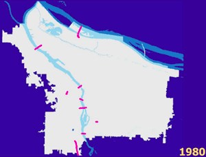
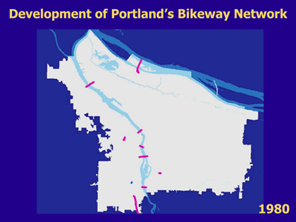
infrastructure, circa 1980. See how it has evolved below.
Portland’s bike network was not built overnight. Most of our bike-specific infrastructure was built in the mid to late 1990s, but it really started in the early ’80s. About seven years ago (before many of you even knew about BikePortland), I stitched together an animation showing how Portland’s bike network has evolved.
Yesterday, something on Twitter sparked my memory of the animation, so I shared it again. Given how it has spread overnight, I figured many folks might be interested in seeing it again (or for the first time). The animation shows the spread of bike-specific infrastructure in Portland from 1980 through 2005 (and then into the future) in five year increments. Check it out:
This really puts what has happened here into perspective don’t you think?
And by the way, the graphics are taken from a presentation given by City of Portland Bicycle Coordinator Roger Geller. Thanks Roger!


Thanks for reading.
BikePortland has served this community with independent community journalism since 2005. We rely on subscriptions from readers like you to survive. Your financial support is vital in keeping this valuable resource alive and well.
Please subscribe today to strengthen and expand our work.
How does the 2030 bicycle plan compare to the “future” map envisioned here? Is it the same or even more expansive?
Beautiful graphic, Jonathan! And incredible, tireless work, as always!
Much of our bikeway evolution has consisted of painting lines and sharrows on busy car-dominated streets, which unfortunately does ZERO for the “interested but concerned” folks. Nearly all of your regular readers, including myself, are not afraid to bike anywhere, so those painted lines and figures don’t do much for us, either–an exception being Williams/Vancouver.
We need to make cycling incredibly safe and easy to navigate for the “interested but concerned” crowd if we’re ever going to hope to get beyond a 10% bike mode split in Portland–and beyond 2% in the suburbs.
I’m heading to Minneapolis in a few weeks, and I cannot wait to check out their incredible bike trail (transit) network. I’ll give you my full report. 🙂 I’ve been to DC several times, and I always take advantage of their wonderful trails when I’m there.
Just imagine the eco-tourism and unbelievable bump in quality of life we’ll enjoy, not to mention $billions saved in health care costs, road maintenance, auto dependence, etc., when (if ever, ever) Sullivan’s Gulch, NP Greenway and many others are (maybe? please?!?) finally completed. Maybe it’ll take a huge, committed volunteer crew to help get these trails built at last!
Cool – great improvement. It seems like there might be a lot of changes from 2005 to 2010 or 2012, but it skips to the Future version pretty fast, so it is hard to tell.
I love this. Can we get a map of “Today” or maybe what will be finished by the end of the summer?
This is great! Thanks for posting it.
Does anyone know what the 1980 stubs in NW and Sellwood are?
That was fun to watch! So much so that, I watched it 8 or 9 times!
Does anyone know where to get this data?
I’d love to make this more interactive and maybe compare the number of miles built with the bicycle counts.
Some of the data is available here: http://civicapps.org/datasets/bicycle-network. But that only has dates for the ODOT projects, not PBOT.
Hey Joe,
This data comes from PBOT and Roger Geller, the man who has been building out this network since the 1990s. Just a few hours ago, I got some really awesome, updated slides from him which show better details and year-to-year progress from before 1980 through 2011 and beyond. I’m working on coverting the slides into an animation and I will post the new animation when I get it done. He also sent info on how bike usage has increased in relation to network development over time. fun stuff and I’ll share more asap.
Great! I look forward to it. I’d still like to get my hands on the actual dataset though.
Progress is progress and something is better than nothing but I totally agree with Tim D. A lot of the “bike paths” in Portland are nothing more than a bike symbol painted in the road shoulder. For example, the vast majority of non-bike riders are incredulous that I would bike along Barbur Blvd and looking at it objectively you can see why. The bike path or road shoulder puts you very close to 30+ mph car traffic and is filled with gravel, broken glass, and sewer drains.
Sharrows would not have saved James Fallon-Cote life.
You guys in PDX don’t know how lucky you have it compared to the rest of the country. In TX the minimum statutory speed limit is 30 MPH in residential areas and the lowest speed limit on roads is school zones which can be no lower than 20 MPH or 25 MPH lower than the speed limit on the road when the school zone is not active. this reasults in some really strange signs(School Zone, 40 MPH), and a lot of bike and pedestrian deaths that would not happen if the limits were lower and also a lot less bike and pedestrian transportation than there should be with our weather and terrain.
I don’t see a key to this data anywhere. What do the different colored lines represent? Without a key, this map is somewhat useless.
The reason I ask is, I *suspect* the green lines are supposed to represent bike boulevards? If so, I am curious why it is showing the NW quadrant as currently having bike boulevards.
NW does not currently have any bike boulevards. Or if it does, they do not have a single traffic calming element on them, which renders them utterly pointless.
Confused! Anyone able to explain?
The existing Bicycle Boulevards in NW are Raleigh, Overton, Johnson, and Flanders – all west of I-405 only. Not all Bike Boulevards have traffic calming elements. Clinton only has one at Caesar Chavez Blvd, for instance. I would agree that they are much less useful without traffic calming elements.
I agree heartily – they are completely & utterly useless without traffic calming elements on them. Without diverters, speed bumps et al, there is absolutely nothing to differentiate a bike boulevard from any other motor-vehicle-dominated street in the city.
If you don’t believe me, go check out the 1000+ vehicles a day using the Raleigh St “bike boulevard” twice daily to access the Conway parking lot.
I believe you, I just don’t agree with you. There’s a difference between “far less useful” and “completely & utterly useless”. As to the particulars of Raleigh, I don’t ride it regularly. The times I’ve been on that portion, I’ve found it to be a pleasant ride and very low-traffic. That said, most of those times were weekends or not during commuting hours. I’d imagine all 4 of those Bike Boulevards could use some calming measures, or re-designation.
I worked in NW Portland for several years, and Raleigh was part of my daily route. I thought it was a perfectly fine place to ride.
I would also like to add that last time I biked it, Clinton also had traffic circles, speed bumps, & crossing facilities at 50th, in addition to the diverter you mention at 39th.
The NW bike boulevards have none of these, bummer.
There is a small traffic circle at Clinton and 47th. There are no calming facilities at 50th or 52nd Avenues. 50th remains a potentially dangerous crossing with limited visibility, no diverters, and nothing to reduce traffic speeds coming down the hill. The only diverter is at 39th.
Right now, the most advanced Bike Boulevard is NE Going. Most of the others, even long-standing ones, have limited calming measures in place. The biggest calming factor is the presence of bike traffic on those roads. SE Salmon is a prime example – also no calming measures along its entire length. SE Harrison is a bit more advanced, with diverters at 20th and 39th, and numerous traffic circles. Clinton has almost nothing, despite being highly used and the oldest of the city’s Bike Boulevards. The recent improvement project only added signage, art, and other treatments to raise awareness of its status as a Bike Boulevard to motorists who use it.
Full disclosure: I was on the Clinton Bike Boulevard Improvement Project Advisory Committee, and I live near SE 52nd & Flavel and ride Clinton on a nearly daily basis.
Very cool.
Thank you for sharing.