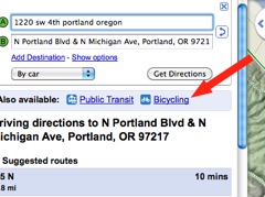
The League of American Bicyclists has just sent out a press release confirming what I speculated (and all but confirmed) earlier today — Google has turned on biking directions for Google Maps.
Google will publicly announce the big news at Wednesday morning’s Opening Plenary Session. About the announcement, the League’s Andy Clarke says, “… It is a game-changer, especially for those short trips that are the most polluting… This new tool will open people’s eyes to the possibility and practicality of hopping on a bike and riding.”
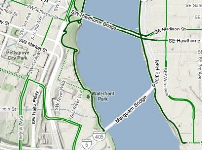
In addition to an option for “Bicycling” directions, Google also has a new layer view that include
According to Google, bike directions have been the most requested addition to Google Maps.
I tried out the feature using Portland as my base location (I’ll confirm tomorrow what cities the bicycling layer works in) and it worked well. With the “bicycling” layer turned on, I noticed it automatically found off-street paths like the Waterfront Park path and the Springwater Corridor Trail.
Here’s a blurb from the League’s press release:
“Simply enter a start point and destination and select “Bicycling” from the drop-down menu. You will receive a route that is optimized for cycling, taking advantage of bike trails, bike lanes, and bike-friendly streets and avoiding hilly terrain whenever possible.”
Read Gabe Tiller tried a route from Northeast Portland to Oaks Park via the Springwater and reports that it’s not the exact route he’d use. Another person via Twitter said it recommended riding on West Burnside, a very unsafe street for bikes.
I’ve got a demo scheduled with a Google rep tomorrow. If you have questions you want me to ask her, leave them in the comments. In the mean time, I’d love to know if the bicycling feature works for you. Give it a try and report back in the comments 1) if it’s turned on in your area and 2) if it works.
Bike Summit coverage sponsored by Planet Bike. More stories on our special coverage page.



Thanks for reading.
BikePortland has served this community with independent community journalism since 2005. We rely on subscriptions from readers like you to survive. Your financial support is vital in keeping this valuable resource alive and well.
Please subscribe today to strengthen and expand our work.
This is incredibly awesome!
It works for me as I look around on bike directions for the Portland area…but they still need to work on providing safe road routes as they recommend for traveling. Some of their provided bike directions and routes seem a little sketch to me.
It works pretty well in Minneapolis.
I’m in Vancouver, WA, and even with the same directions, I’m not getting any option to select cycling.
Salem is up and running.
PS. Do you know whether Google knows about the county and city maps that show biking routes in OR?
I am so excited about this!
It works here in San Diego but it is not perfect. We do have canyons to contend with…
How exciting! Just as a test I did directions from E. Gresham to where I work in NE Portland and it gave me a crazy long route with a couple sketchy intersections that I’d never take. Hopefully it gets a little smarter over time.
Fantastic! Google maps bicycling layer is up for Davis, CA and Sacramento, CA. A brief test of the mapping looks like it recommends longer, more scenic routes, but hey its a start! I’m so glad its finally here! 🙂
Cheers and thanks for the head’s up! 🙂
Works well in Eugene. This is a big deal.
This is great! I wonder, however, if this bicycling feature could be met with concerns from property owners on whose property cross some of these paths. I could see that some paths may be popular but are not legally recognized. Maybe Google could give us some insight into how these paths were selected?
Update on my comment I just made regarding the route from Gresham to NE PDX. I realized that the bike feature doesn’t recognize bike routes in Gresham, with the exception of Springwater. That’s probably why it gave me an odd route (clear down to Springwater over to I-205 path and up to another strange route that I wouldn’t choose).
Forgot to mention in the post initially… but if you have specific questions for Google, please let me know and I’ll ask them and report back. thanks for all the feedback.. keep it coming.
It’s working now, but it won’t allow you to drag the route to legally ridable freeways, and even otherwise limited-access roads. While this probably isn’t a concern for most, it’s certainly a deal-breaker for me, especially in a few locations where it’s the only option.
What they really need is a sliding scale of route difficulty, so that each cyclist can adjust the mapping to his individual skill level. That would be perfect.
William from Copenhagen here.
It seems that it’s only enabled for US territories, incl. Alaska and Hawaii. As soon as you move around on the map, the bicycle option simply dissapears.
Even though we have our own, for Copenhagen and the surrounding area, it’d be good to have it incoorporated in Google Maps.
(Use caution when clicking the links. They are only included for the curious, and are 5 and .8 MB PDF-files.)
Congratulations on your new route-planning tool.
3 days and 22 hrs from portland to boise
Eugene’s is great, but misses a few “traffic calmed” streets in favor of parallel bike lanes streets a few blocks away.
It’ll never beat experienced local knowledge, but it will be great for new and average riders, and especially students and visitors!
love it. it does not always give the best route, but the results will get better with time. i did notice that, like with the car directions, you can drag points around to alter the route and google automatically updates its suggestion. if you think of it, ask the google rep if they will be mining user interactions like this route altering to help produce better results.
pdx: no way to get from i205 path onto powell: even when you drag to change the route it jumps onto se 92nd. but there’s a lovely overpass to cross powell, really!
New post on the feature in Eugene is up on WeBikeEugene.org. It’s working great. I love how it shows all the cut through paths in the neighborhoods!
It’s missing some “goat trails” obviously but seems to have all the paths, bike lane roads, etc.
VERY exciting!
http://www.webikeeugene.org/index.php/2010/03/googlebikethere/
Glad to have Google Bike Maps. I would like to know if Google will bring to the mobile world. I would presume Android first but what about iPhone and other smart phones?
Could you ask the rep Google’s plans for (crowdsourced) updates for optimized bike routing solutions? Where did they get their data for Portland (or the Region)?
Can their routing algorithm handle turn impedances?
When (how) are they going to update their bike network?
If someone has better data for their model, who should they contact?
12 days and 10 hours to Boston, but the time will just fly by because you will be busy navigating through 1736 steps worth of directions.
On a more local note, a trip from SE to the Mission Theater sends you up Couch. I would probably ride straight up Glisan. Clearly it will be difficult for them to please everyone. A trip from SE to PSU involves some interesting contortions at the east end of the Hawthorne bridge as well as downtown. I’m sure it will take some time for them to refine the results.
“I’m not getting any option to select cycling.”
click around on some different things, i found it and it looked different than the picture above
It’s interesting some of the routes. They’re mostly okay, but they take some adjusting.
They seem to magnetize to the green routes that are marked on the map, even when a quiet and direct side street is available. For example, I’d rather bike east to west from Hollywood area to downtown using NE Knott than I would NE Broadway, but it gravitated to Broadway presumably because of the bike lane.
Jonathan, please ask Google to provide a legend for their bicycle overlay. What do the different shades of green and solid v. dashed lines mean?
Oh, another question for Google. How do we provide feedback for fixes?
For example:
Heading westbound on Broadway over the bridge, it actually shows bikes crossing to the southern sidewalk at the bridge and then back to the proper travel side after the bridge even though they show the north side of the bridge as a green lane for bikes (which is seemingly only approachable from N Larrabee Street and not from N Broadway itself).
I can still, under no circumstances, make a bike option appear. I’ve tried routes all over Portland. From my home on Mt. Scott to Downtown, various places around town, even routes contained completely within downtown.
Car, Public Transportation, or Walking … that’s it.
In Portland, we’ve had bycycle.org for a while, and it probably does a better job since google is still in beta. I’d be interested to hear people’s opinions on any differences though.
I’m impressed that it charted a different route for me when I reversed the direction. Google Maps wisely knew it is not a good idea to try and bike up Taylor’s Ferry from the Sellwood Bridge, but that going down is fine!
This is awesome! Thanks Google!
Smaller cities seem covered as well. South Bend, Indiana is on the biking grid.
Working for Orange County CA. Tried to view route on G Earth. I could not get that feature to work. Showed up in folder but would not display on map. Ask G if they are going to let us import the route to Garmin Edge for bikes. They should make it a simple link right from maps to save the map to a compatible file.
Corvallis is up; directions for my daily commute (which I’ll start in 40 mins) are hilariously inappropriate. There’s a notice: “Bicycling directions are in beta.
Use caution and please report unmapped bike routes, streets that aren’t suited for cycling, and other problems here (link).” So it looks like the process of crowd-sourcing corrections and updates has begun. You’re off to a promising start: Thanks, Google!
It’s kind of whacky in Chicago.
It’s kind of whacky in Chicago: http://www.flickr.com/photos/jamesbondsv/sets/72157623465649997/
Bike directions work on Google Maps for the small town in northern Wisconsin where I live.
For a local destination a couple of miles away, it selects the paved multi-use path that is available.
For a neighboring town, it gives a 10-mile option on highway with shoulders as well as a 16 mile option on calmer roads.
It also came up with directions that seem largely off the main highways to towns about 40-70 miles away, to Madison about 350 miles away, and to Portland a few thousand miles away.
Way cool!
My commute is spot on. I take a shortcut through a park MUP that has never shown up on Google maps until today. I commute from Sherwood, OR to Tualatin, OR.
Trying it out now. Looks awesome.
Google isn’t aware of the 205 being fully reopened now. It stops at SE Harold on the map. It also doesn’t recognize the full length of the i84 path.
‘Bicycling directions are in beta.
Use caution and please report unmapped bike routes, streets that aren’t suited for cycling, and other problems..’ (link is on the map left nav.
There’s the main page up now: http://maps.google.com/biking
The video on that page answers all of my questions above about making corrections and what do the different green lines mean.
http://www.youtube.com/watch?v=JN5_NBSu7Lw
Well, it passes the 16th and Tillamook test for Portland.
Here in Corvallis, I have sent in my first feedback on a missing path. Thinking of the folks who will be doing the manual entry of the new data, I gave them a point to point route from one end of the path to the other and included a link to the city’s local bike map for reference.
Also entered their drawing. Thanks Google!
The “green” is up and working in Miami, but how Google picks a route isn’t the best for biking.
For example, there’s a big rail trail that Google didn’t use but instead routed me all over the place to get from point A to B.
Where I see an immediate benefit is the “sight”ing of the green areas of bikes.
What is quite obvious in looking at Miami is there there are few, if any, connected bike trails/paths, etc.
I’d be impressed if I could save a TCX or GPX file. Better yet upload one, modify it, and then save it. And view climbing profiles.
I don’t ask for much. 🙂
(and am partial to bikeroutetoaster.com).
I was having trouble just like those in some comments above (3 & 26). The option simply wasn’t showing up in the pull-down menu. Finally, I tried it in Firefox and it worked great. Also works in IE.
But here’s the weird part: the browser in which it isn’t working is Google Chrome!
I also feel like it prefers arterials with bike lanes to side streets (bike boulevards in Portland’s case) I can understand how in some towns/locations this may be a better option, but I would hate for the general, new-to-biking public to think that these busy streets are the only way to go when a lovely, easy, and safe option exists a block or two away.
Finally!
A route from Vantucky out Marine Dr. to Bull Run & [the town of] Sandy and back along the Springwater to the Steel Bridge, which I mapped using “walking” mode around 0100 hrs today only changed by a fraction of a mile in “bicycle” mode over its @70 mile length.
Comparing a previously mapped “walking” route from Hayden Island, Portland, to Chicago, however, the length increased by over 300 miles and the time decreased by twenty (20) days! We’re talkin’ RAAM-class bicycle travel speeds now; obviously, not intended as a tour planner, methinks. ‘Specially considering the super-isolated routing cross-country (skipping way too many towns along the way – I’m all for isolated, adventurous riding, etc. but where ya gonna tank up?).
To Google’s credit, the database automatically routed along the Cowboy Trail in Nebraska, passed within 20 miles of Le Mars, Iowa (Ice Cream Capitol of the World), and made good use of the rail-trails & MUPs in Illinois leading to Chi-town. Except for the odd increase in mileage and Tour-de-France speed projections, I’m genuinely impressed.
Interesting.
On the Get Directions tab I entered my home address and my work address to see what routes it suggests.
This is from Tigard over by Walnut St to Durham over near I-5.
One of the options it gave me was to go down Walnut (no shoulder or bike lane, signed 30 and everyone goes 40+) and over to 72nd (even worse than Walnut, heavy traffic, no shoulder or bike lane).
The other two options had me cutting through neighborhoods, making lots of unnecessary turns when it would be faster to stay on Hall which has a nice bike lane.
The directions feature for Tigard seems to prefer neighborhood streets and side streets to arterials, which means people are being routed up and over a lot of hills.
So– directions are a little wonky, not the way I’d go that is most direct and safe (the directions for the reverse of my commute says to ride up McDonald– which I wouldn’t do even if you paid me!) but at least show you some options.
Drag and reposition route works well.
The bicycling layer seems to stop where Hall runs across hwy 217, and doesn’t include anything in Tigard besides the Fanno Creek Trail. For LO, it only includes the Tryon Creek Trail.
Do they have plans to expand this feature out into the surrounding towns? It makes it look like Portland is a bicycling island surrounded by hostile waters. Which it isn’t in reality.
So, like, in relation to longer routing (touring or other longer trip applications) that whole speed thing could be resolved simply by Google showing it as total hours rather than days and fractions thereof. Few humans ride their bike in whole-day increments, 24 hours or more in a row (and you randonneurs know who you are), so showing hours would simplify calculation for travel logistics.
Tested it from home to work… made a correction, it had me turn left at SW Allen (from Lombard), I made a correction. Turn left at SW Denny instead.
For those of us who don’t watch youtube at work, would someone please explain the difference between solid green roads and dashed green roads?
Thnx
Hi Jonathan – I’d love for you to find out where/how is Google getting source data and will they work towards a national standard input format like GTFS for transit?
It’s working now for Vancouver, WA, but I don’t entirely agree with it’s choices. Going from downtown Vancouver to Troutdale it suggests crossing the I-5 bridge to Marine Drive and cutting south at 138th. That’s probably a little flatter than riding to the 205 bridge and then following Marine Drive the rest of the way past the Troutdale airport, but it’s definitely not what I would choose given lights, traffic, and dealing with the I-5 bridge.
On the plus side, it has finally realized you can go through Delta Park on Whitaker to get to the I-5 crossing and Marine Drive. The walking directions never allowed that.
So the bike lanes and green markings end just as Portland becomes Beaverton and it gave me weird routes that ignore all the great lanes that Beavertron and Hillsboro have added over the years, but I sent a “Report Problem” to Google to let then know about the bike lanes that I use on a daily basis. I’ll report if they get back to me about that.
I’m stoked about this and I hope that they mine all of us for “Best Routes” because that would just make this feature so awesome. Yay!
folks.. i’m hearing all your questions. I did a Q&A with Google guy that I’ll publish as soon as I can get to it.. thanks.