This story is part of my ongoing coverage of the 2008 National Bike Summit. See the rest of my coverage here.

An effort to stitch together thousands of miles of designated bike routes across the country is gaining steam in Washington. With the help of a key partnership with the Adventure Cycling Association, the American Association of State Highways and Transportation Officials (AASHTO) has renewed their effort to develop a U.S. Bicycle Route System.

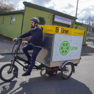
of the Adventure Cycling Association
has been a key player in making
this dream a reality.
(Photo © J. Maus)
The effort began, in policy at least, some twenty years ago. But since that time only fragments of two bikeways — the TransAmerica and Atlantic Coast routes — have been officially designated. Then, in 2004, AASHTO passed a resolution to establish and extend the system and to create an ad hoc Task Force to develop a recommended national plan and blueprint for the program.
A key member of that Task Force is the Adventure Cycling Association, a non-profit that has mapped over 37,000 miles of bike routes in the U.S. Since 2005, Adventure Cycling has provided staff assistance for the effort and they have been relentless advocates for the project and have worked closely with AASHTO to move it forward.
Jim Sayer, Adventure Cycling’s Executive Director, has been a tireless advocate for this project and he says all the work is about to pay off. “We’re on the verge of it finally moving through and having AASHTO approve the final plan,” he said, “and once all that comes to pass, we can start putting routes together.”
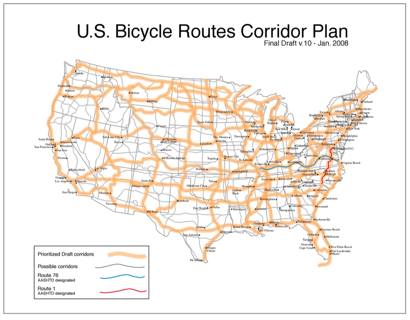
According to Sayer, there are no set routes yet and the plan is to establish a system of “corridors” — 50 mile wide bands that give rough parameters to help establish the routes. He also says the standards are not yet set for what type of path, trail, or road the routes would be (*Update: Read Mr. Sayer’s comment below for more information.)
Time-frame for final approval is expected to come this fall when AASHTO’s Standing Committee on Highways will take a final look at the plan. Between meetings on Capitol Hill today he told me, “It’s exciting because they’ve historically been focused on moving cars, not bicycles.” Sayer says the project has been a collaborative and deliberate effort; “We’ve really taken our time, but it’s paid off because everyone involved feels really invested in the project.”
Once complete, the U.S. Bicycle Route System will link cities, towns, and regions together with a publicized, maintained, and signed network of bike routes that will, according to the Adventure Cycling website, “connect communities and ensure opportunities for future generations to travel by bicycle throughout North America.”
For more on the U.S. Bicycle Route System, go to AdventureCycling.org.


Thanks for reading.
BikePortland has served this community with independent community journalism since 2005. We rely on subscriptions from readers like you to survive. Your financial support is vital in keeping this valuable resource alive and well.
Please subscribe today to strengthen and expand our work.
Jonathan, see also the National BIcycle Greenway.
I\’ve ridden a few sections of those posted on the draft map – most recently the San Diego to El Paso segment AND while there are already some posted routes and maps availabe, which very are certainly helpful, the real problem is working to make the routes more bike friendly – with at minimum an appropriate sized shoulder (in addition to what\’s dedicated to rumblestrips- hello AZ) for cyclists. Some of the routes posted are downright harrowing for a loaded touring bike, no matter how traffic savvy or experienced the cyclist. So, can anyone clarify how this program plans to address such issues? Or has been addressing them/is working to improve conditions on the routes identified?
While this is a great initiative, it falls squarely into the \”bicycles for recreation\” mindset.
Nobody will use an interstate bicycle route to directly replace a car journey that they would have taken otherwise. They will be used purely for the purpose of using them.
A higher priority is establishing and developing local bicycle routes, to encourage the use of bikes as an everyday transport option.
A local bicycle route need not be a separated cycleway, nor even a marked section of road. Some would argue that it should be neither of these things.
A local bicycle route should be an entirely continuous planned path where cycling is easy.
On road or off. Avoiding (or managing) busy intersections, avoiding momentum-robbing stop/start junctions, providing adequate road space to ride a bike without conflict with other road users.
Local routes will allow bicycles to be used as transport – as a part of daily life – rather than as a discretely defined activity to indulge in one\’s leisure time.
I doubt the routes are going to be anything that most people will feel safe taking there kids on. Which is really too bad. I believe it is our damn right to have such a national bicycle route.
Seems like in the late 70s when I used to train out of Pacific City in the summers, there were BikeCentinial route markers up and down the coast. I think it was a cross-continental route.
Does this mean that the designated bike routes get bike lanes? separation between traffic, color marked lanes, traffic calming devices. B/c I\’ve personally toured about 80 percent of these routes, literally 3/4 of the map and while some of these routes are wonderful, many are dangerous, harrowing, and downright unusable in their current state. I need to educate myself about what it means for a road to be part of the bicycle route system? Can anyone educate the readership in a concise way. If this amounts to signage and disignation status only, I, for one, will be dissappointed.
Does this mean that the designated bike routes get bike lanes? separation between traffic, color marked lanes, traffic calming devices. B/c I\’ve personally toured about 80 percent of these routes, literally 3/4 of the map and while some of these routes are wonderful, many are dangerous, harrowing, and downright unusable in their current state. I need to educate myself about what it means for a road to be part of the bicycle route system? Can anyone educate the readership in a concise way. If this amounts to signage and disignation status only, I, for one, will be dissappointed.
I\’m a bit curious. I\’m planning on doing my first cross country tour next summer and while this plan wont help me then it\’s sure nice to thing about. It hard to imagine a lot of headway though when it\’s already been 20 years. I\’ll keep my fingers crossed though.
I\’m imagining speed bumps and traffic circles on highways from coast to coast.
This is a great effort. Thank you, Jim, for the inspiration.
And from this can we now imagine a national bike/ped FREEWAY system?
Touring would be one great aspect of such a system.
The bike/ped freeway system would be designed to tie communities together and give commuters a safe route free from automobiles. It would be safe enough for children, elderly and the handicapped to use.
You may say that I\’m a dreamer
But I\’m not the only one…
I know my state and the Dallas-Houston route looks like it\’s right on top (part of?) I-45. The southern route out of El Paso looks like it stays with I-10 for about 350 miles (not a bad idea, that\’s real pretty country to look at, and the only facilities of any kind are right next to the freeway). So in TX at least it is a bike Interstate, on or next to the car/truck Interstate.
Like I said, in some places they coiuld do lots worse…
Tim Paton has some good points…
I mean, don\’t get me wrong, I like the idea of having long distances of roadway available for biking, but I\’d really rather have a safe every-day route to ride to and from work, the movies, etc.
I could wish that the above referenced map would name the highways and freeways involved, as it looks like they\’re planning on the length of 101; the length of hwy 97; OR I-84 or WA hwy 14 or WA I-82; OR hwy 126; WA hwy 12… and a lot of these roadways have really inadequate shoulders and high speeds.
I like this idea.
It seems strange to me however that the map appears to be a set of existing large highways (not interstates) with certain routes highlighted. When I go out on a tour, I spend time with local maps finding the smallest, least used roads to travel on. In my experience, the two lane roads with high speed limits they selected are some of my least favorite to ride on.
Jonathan,
Thanks for the great post. Just got back from Washington and would like to respond to all the comments briefly — all very good responses to the first phases of this big national effort. Just please note that these are \”corridors\” — 50 mile wide bands that give rough parameters to help establish routes — not necessarily Adventure Cycling\’s existing routes. There are so set routes yet, so don\’t presume anything. Also, please know that the standards are not set for what there routes could be — backcountry roads, hard pack trails, highways with decent shoulder and no/constrained rumble strip. If you go to the weblink, you can get more detail. The beauty and challenge of the project is that many interests are engaged, people can help develop the interstate routes (after the corridor plan is adopted), and there may even be interest at the national level in helping with resources to sign and maintain a national network. We\’ve had some positive early meetings with several members of congress, including Congressman Jim Oberstar, who was very enthused about the project and wrote (along with Cong. Peter DeFazio) a glowing letter of support.
BTW, I agree with the writer who said this is no substitute for local routes and metro networks, which are critical for transport (and even recreation). The US bike route system will be complementary and can act as the linking framework for these metro networks and other key destination points, like our national parks. This is similar to the urban/suburban/rural model that is being used in Great Britain. Their National Cycle Network has created an investment focus that has drawn over $750 million in national lottery proceeds and growing popular support — plus surveys are showing dramatic growth in trips on the network, leaping from about 225 million trips in 2005 to 338 million in 2006.
Obviously, a lot to do and talk about — just glad Jonathan got it rolling.
If you have questions/thoughts, review the background, share ideas here, or contact me or Ginny Sullivan, our very tenacious, good-spirited New Routes Coordinator at 800-755-2453 or our first initial and last name at adventurecycling.org.
Thanks for your interest.
Thanks for the added information Jim. Can\’t believe I didn\’t mention the bit about the corridors being 50 mile bands. I\’ve just gone back and edited the story and included a link to your comment.
Keep us posted on the progress and thanks for all your work on this project.
A quick look at the google shows me ACA is actually an offshoot of BikeCentenial.
Live a day, learn a little.
Trying not to be negative but I also echo the usefulness of such a network. Many European countries are doing the same but none of the are much larger than … well, Oregon. At a state scale such a network is much more useful and likely to have a positive impact on the daily needs of local cyclists.
Also, having done some very extended bike touring, I very rarely found myself sticking to predesignated bicycle routes when they were there. They just didn\’t go to the places that I wanted to and so I ignored them and went my own way.
However, living very close to the route of the East Cost Greenway, the idea of such a trail has been the spark that has gotten many local trail and other bike/ped projects going and constructed. Some of these projects are and will be very useful to people who ride bikes locally. Hopefully, this project will have the same effects.
Finally, and again not trying to be negative but I have to say that I really question the usefulness of the Adventure Cycling route guides. I saw the ACA guide for the route to take people out of NYC and through New Jersey to PA. The roads that were chosen were far from the most scenic nor the safest. I do understand that may have been done to limit confusion but the designated route through western New Jersey actually went on the some of the more unpleasant roads while there were dozens of much better options all around the chosen route.
Again this is all meant to be positive criticism. I know its a big country and it\’s impossible to know every possible route but when I saw this issue with an ACA route in my local area that I know very well, it made me further question the usefulness of the route guides elsewhere.
That said, I\’d be glad to proof any routes for ACA in New Jersey and I due wish you the best of luck.
Andy B — no problem, we welcome any constructive feedback. Another benefit of this project is that it may stimulate some states to take the idea of bike networks more seriously. If you look at the inventory we did, you\’ll see some states have completely blown off the idea of a network. This project may help reverse those decisions.
Re: New Jersey routes. Please feel free to offer edits/suggestions. Generally, we get very positive reviews of our routes, in part because they\’re generated with a LOT of rider input. It\’s always a balancing act (especially in this country) between distance, topography, traffic volume, speed. Our map correction/input form is here: http://www.adventurecycling.org/routes/correctionform.cfm
Let us know what you think …
Thanks for diving in with info and links, Jim. I know you\’re plate is full over there in Missoula, but it speaks volumes that you\’ll take the time to post more info and clear up some questions. After spending time with the map and links I see where this is headed with the 50 mile bands. Anything that gets this project and the concept of bicycles as transportation and routes to use them safely on has my backing. Have you guys done break out budget wish lists for what needs to be done on various routes? (signage, bike lanes, calming devises )
Keeping a national route concept in the congressional and public eye it can\’t help but get some attention.
Jim — can you explain why designating \”50 mile wide corridors\” is of any value? Imagine designating Eugene-to-Portland as a corridor. The cyclist still needs advice on whether to ride I-5 (no), Hwy 99E (hell no), Peoria Road (a lot better), or minor roads such as Powerline Road (even better). Doesn\’t every proposed corridor contain a mix of good and bad cycling routes?
Tim — don\’t be so certain that \”Nobody will use an interstate bicycle route to directly replace a car journey that they would have taken otherwise.\” I chose to relocate from Houston to Oregon by bicycle once (avoiding a drive or plane flight to my new job) and I\’m sure others have done the same. But I agree with the spirit of your post — recreational touring and daily commuting are very different activities.
I\’d love to fill out that form but I saw the route guide just one time and do not have access to it. My observations are from a carefully examining that one time.
The US bike route system will be complementary and can act as the linking framework for these metro networks
If it\’s meant to link metro networks, the proposed design does not do the job. There are glaring missing links on the map, along many key transportation routes. (The immediately obvious ones are Madison – Rockford – Chicago, and Harrisburg – Baltimore, but I\’m sure there are others).
Hi all — a few replies —
Andy B — pls get us your contact info — we\’d be glad to get your feedback — our cartography team is interested in what you have to say.
Emily and Brian — again, I encourage you to see the process behind the project, which is on our website.
To create the specific network, our task force thought the best approach was to build a sense of trust first. So … we did an inventory of what\’s on the ground, so everyone started with the same info … second, we developed a basic corridor plan — it is a framework — the 50 mile wide bands are NOT routes, they are general \”desire lines\” on where routes could go … again, the idea here is to build support/buy-in for a system .. as someone noted earlier, AASHTO has not been much focused on bikes for the last half-century or more … rather than plunge in with a recommended set of routes and scare everyone (probably even some advocates), we started with the corridors, which as stimulated a lot of very good discussion and buy-in … once AASHTO signs off on the corridor plan, then we go to the nitty gritty of specific route creation, starting with the states that are really enthusiastic. Also, the task force created a priority set of corridors, but if we find enthusiasm for connecting routes (say, connecting to Madison), we will pursue them. This is a long-term project and the goal will be to build in pieces and help DOTs and others see the value of bike connections at a broader level (kind of what we\’re doing with MPOs at the metro level).
Here\’s the link again to the web page:
http://www.adventurecycling.org/routes/nbrn/usbikewaysystem.cfm
Here\’s the one page fact sheet w/ a little on the process:
http://www.adventurecycling.org/routes/nbrn/factsheet.pdf
Enjoy and thanks for your interest —