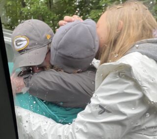
(Photo: Clackamas County Sheriff’s Office)
A planned mountain bike ride turned into a nightmare for Milwaukie resident Rachel Eggers.
Eggers, 43, went for a ride on Saturday morning that began near the Clackamas River southeast of Estacada. After following the river for about 10 miles she crossed a bridge onto National Forest Development Road 45. Eggers then began to climb into the Memaloose area and a series of mountains to the south.
Eggers is a very experienced and strong rider. When she stopped communicating with her family around 3:00 pm, they called search and rescue. The Clackamas County Sheriff’s Office got the call around 8:00 pm on Saturday. They assembled a rescue team and searched through the night.
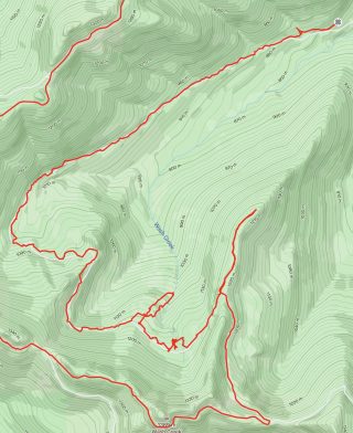
According to her GPS track on the Strava ride-sharing app, Eggers appears to have first run into trouble 31 miles into her ride. Just after Wash Creek Butte (elevation 4,500 feet) she made a wrong turn (see above). After doubling back she loses a lot of time looking for the road. At one point it took her about an hour and 40 minutes to travel 0.6 miles. The GPS track shows her repeatedly leaving the roadway for several miles until she stops at mile 36. Strava recorded for 13 hours and 17 minutes; but her actual moving time was just 7 hours, 43 minutes.
Advertisement
At 3:00 am, the Sheriff’s search team called for more help, including the trail running team (off-road ultra-marathoners), canine teams, and a search aircraft. “Search crews were dealing with the severe weekend weather, including thunderstorms, as well as the hazards it had caused, such as fallen trees,” a statement from the Sheriff’s Office says.
Eggers was located about 6:30 a.m. She was not seriously injured and was able to walk out on her own and has been safely reunited with her family.
The Sheriff’s statement says she planned to do a loop, returning via Old Fish Creek Road but the road is decommissioned and was impassable. Once Eggers became stuck and lost, she abandoned her bike and tried to hike out.
Commenting on her ride via Strava, Eggers wrote about the perilous journey, “I nearly died… Just very happy to be alive and with only bruises and abrasions.”
Be careful out there folks.
— Jonathan Maus: (503) 706-8804, @jonathan_maus on Twitter and jonathan@bikeportland.org
— Get our headlines delivered to your inbox.
— Support this independent community media outlet with a one-time contribution or monthly subscription.


Thanks for reading.
BikePortland has served this community with independent community journalism since 2005. We rely on subscriptions from readers like you to survive. Your financial support is vital in keeping this valuable resource alive and well.
Please subscribe today to strengthen and expand our work.
I am glad this turned out well. Getting lost is super scary. It serves a reminder to download a map on the phone before exploring new areas. Those still work even when there is no reception.
Note that she was out in a wooded area in storm conditions — GPS can be unreliable in such situations, is not a substitute for a compass and map, and can run out of power when you’re slowly working your way out. Also, downloadable map data is sometimes inaccurate in important ways.
A PLB or satellite communicator is a good choice for people who go into remote areas. Injuries like a broken leg or even a torqued ankle that are no big deal in populated areas can be outright life threatening.
It has been requested that people recreate conservatively as the pandemic complicates and increases the risk of rescues.
You can cache a section on google maps for offline use, if you don’t have a pdf. This can also use the phones gps to put you close to where you are. A map is great, but if your cross streets are unnamed road and unlabeled road, it can be a challenge.
I recommend against Google Maps for remote use. It may be better than nothing, but it’s virtually useless for serious use. I personally use Backcountry Navigator and Avenza Maps (ironically, I just received a response from Avenza today regarding a query about the lack of Mt Hood National Forest MVUM maps in their system — turns out the current NFS maps are too old and they’re working on upgrading them)
Becoming too reliant on phone based technology is dangerous even if it is often helpful for the simple reason it can fail you for all kinds of bizarre reasons.
By chance, I got caught in the storms Saturday night a number miles out in a backcountry (I was on foot, not bike). Between the horrible visibility and conditions that caused GPS to fail, I managed to get lost in an area I’ve been in a number of times. In the end, my old school magnetic compass allowed me to plot my way to my destination — 4 extra hours of hard work in challenging conditions.
Large numbers of downed trees, landslides, etc. can make a dramatic difference in how passable paths are, and even if you start on a path, it’s surprisingly easy to get into a situation where you have no idea where the path is.
It looks like Strava shows a road here that doesn’t exist? Looking at Google Maps and the satellite view, I don’t see any roads along Wash Creek here. Perhaps an old logging road?
The terrain overlay is the truth teller in mapping these old roads. I have spent a lot of time in those woods and old roads can be a lifesaver. But yes, a calling ahead to the forest service would be a good idea to see what hasn’t been decommissioned.
It’s a shame they decommission roads like they do. Many are left in terrible and unwalkable condition.
it’s better to let them return to nature if they’re not being used.
Is it just me, or does 7 hours and 43 minutes sound like a lot of riding in the woods, lots of climbing? The word “just” doesn’t do justice to the number of calories she burned in her struggle to find her way back. I’m amazed she persevered and I certainly congratulate her. I very much doubt I’d be able to do the same.
I used to carry a lighter in my camelbak for safety meetings… Now I think I need to put one back in there just in case I have to spend the night in the woods somewhere. The woods get steep & burly back there. Does anyone know what loop/ride she was attempting? Or was this more of an exploratory ride? Glad she’s ok!
Honestly, going out where she was, I would say the 10 essentials are a minimum. It’s wild country out there, and that area is a labyrinth of logging roads. Very easy to get lost.
This. An unlucky mechanical or injury could easily keep you out there much longer than intended even if you don’t get lost.
I’m very glad Rachel is all right. It doesn’t take much for even an experienced backcountry traveller to get into trouble.
This type of nightmare scenario is why I now always carry a Garmin InReach Mini in the backcountry. It provides two way communication and an SOS function. It isn’t cheap and requires a monthly subscription, but it makes me (and my wife) more comfortable when I venture into the woods and out of cell range.
Glad she’s OK and has learned to be better prepared for her next wandering into the woods. That area all up and down the Clackamas far more perilous than most people realize.
Tip your hat to the volunteer Search and Rescue crews that put themselves at risk so others may live.
Let’s hope it’s not already in a chop shop.
Glad it turned out OK. Could happen to anyone and I’ve often been under-prepared but so far always lucky. I now carry a bit more (tarp, light, extra layer) but still marginal.
Cool to hear ultra-marathoners will run out to search. I’d volunteer to be part of a MTB crew like that, although bikes require decent roads or trails.
I wonder why it took 5 hours from the first call for help until the Sheriff put a team together – maybe I’m missing something there.
If you want to get involved in mountain-bike SAR, the team that does that is Pacific Northwest SAR: https://pnwsar.org/
If someone says they’ll be home at 5pm, it’s not normal for their family to be calling 911 at 5:01. It’ll be 7pm, 8pm, maybe 11pm, midnight or even later before 911 gets the call. The 911 center collects minimal details and pages a deputy SAR coordinator, who has to drop whatever they were doing before to pick up the SAR call. To even begin searching, it’s necessary to find a starting point — where the subject was last known to be. That can take time, especially if the person calling 911 doesn’t have the subject’s exact plan or know their intended route. Or if the subject deviated from the plan they communicated to their at-home emergency contact. Then the SAR coordinator has to get to that location, which could be an hour or more. Once it’s established where the subject was and that they aren’t a danger to themselves or volunteers, then SAR volunteers can be called. They all have their own lives and have to drop what they were doing, collect their SAR gear, and drive to the search location: another 2-3 hours, or longer if there’s appreciable traffic or the location is especially remote. If specialty resources are needed or are not locally available, those volunteers might have to come from multiple counties away, or in eastern Oregon, maybe from halfway across the state. A five-hour response time is pretty good, as these things go.
It looks like someone has already removed part of the road from OpenStreetMap (the open source database which is used by Strava and many other map providers). Can anyone with more local knowledge of this area check if the remaining segments of road still exist on the ground? Here’s the area in question: https://www.openstreetmap.org/#map=14/45.0270/-122.2325
When in national forestland, the data I would generally trust is the Forest Service. It shows no trail there: https://caltopo.com/map.html#ll=45.01542,-122.19101&z=14&b=f16a&o=r2&n=0.4. There are maps floating around that show a trail, but it hasn’t been there for 15 years or more. It’s impassable and not even recognizable as a path anymore.
More importantly, this is far from an isolated example. Any trip plan to a new area should have a contingency for “the map was wrong” because there are many places where reality on the ground doesn’t match the map, even without thunderstorms blowing down a lot of trees and debris that can make even the maintained trails impassable.
No. For many reasons, SAR rescues people, not equipment. The same is generally true for people who get their automobiles stuck (usually in snow).
Search and Rescue is often volunteer lead and run by regular working folks who backup the local law office. Also, 20 some bucks a year gets your 100,000 bucks in evac coverage through garmin. It isn’t perfect, but it’s better than nothing. Garmin also sells a good GPS SOS device…well tested.
A little late to the comments, but I had gentle (maybe an extra hour or two) in the tilamook forest just a year ago. LESSON 1: No matter how invested you are into trail or road, JUST TURN AROUND and backtrack. The road petered out, but I was “sure” the trail i was trying to intercept was right over there…
AND THEN Its amazing how quickly you can get into situation where to go just 20 feet takes 10 minutes or so. THUS lesson 2: One should NEVER go off-road or off-trail, at least with the intent of getting somewhere / saving yourself.