
“We want to think big about what it means to create plazas to let businesses spill into the streets.”
— Nick Falbo, PBOT senior transportation planner
The City of Portland is on the verge of unleashing one of the most innovative and potentially transformative street-related policies we’ve ever seen. And in a flip-the-script moment only an unprecedented pandemic could create, their main argument for using more street space for people — and less for drivers and their cars — is to help businesses survive.
“PBOT is more than just an infrastructure agent. We are what helps make business work.”
— Art Pearce, PBOT Policy, Planning and Projects Group Manager
We shared news yesterday of the upcoming program from the Portland Bureau of Transportation that will allow local business owners to apply for permits so they can offer food and other services in the public right-of-way. This goes far beyond a simple sidewalk dining permit and is expected to fast-track a host of new possibilities like customer queuing zones in what used to be parking spaces and dining tables and barber chairs in streets and parking lots.
Yesterday one of the PBOT planners spearheading the effort, Nick Falbo, gave a preview of this program and an update on their Safe Streets initiative (they’ve dropped the “Slow Streets” part) to the PBOT Budget Advisory Committee.
Falbo made it clear PBOT is serious about changing streets — not just to adapt to the current moment, but to lay groundwork for whatever comes next. He called Safe Streets, “A framework for our path to a better future.” And Falbo’s boss, PBOT Policy, Planning and Projects Manager Art Pearce, said a host of measures designed to create space for business in the street is directly tied to economics.
“PBOT is more than just an infrastructure agent,” Pearce told the committee. “We are what helps make business work. Getting goods to those businesses and also helping them survive. It’s a critical moment for that intervention and for us to make right-of-way available for that use.”
Those are strong words from an agency often marked (true or not) with an anti-business label.
PBOT’s current mojo is due in part to the successful implementation of 100 sets of signs and barricades on neighborhood greenways. Despite a claim made recently in a Facebook comment from PBOT Commissioner Chloe Eudaly that the barricades have “a lot of opposition,” Falbo took a different view. “We’ve gotten tremendous, positive response to this program,” he said.
Advertisement
While PBOT monitors the barricades and considers making permanent diverters later where necessary, the big news from yesterday’s meeting were the updates on the other two pillars of the Safe Streets initiative: Adding space for people and businesses on main streets.
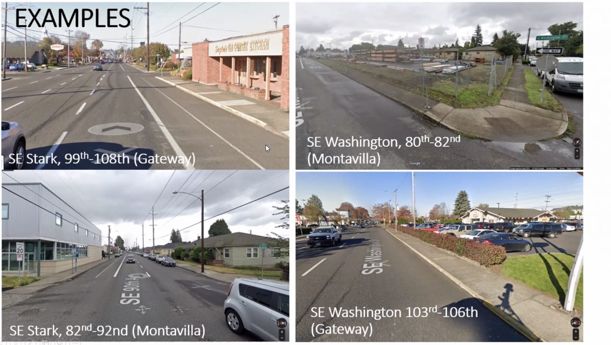
Falbo revealed that PBOT is focusing the first phase of their implementation of wider sidewalks in east Portland. Locations are being selected based on the city’s data on equity gaps and walking demand. A map and examples (shown below) highlighted neighborhoods from Montavilla to Rosewood, Parkrose to Lents. PBOT will lean on their PedPDX Plan which has already identified “pedestrian districts” in these areas.
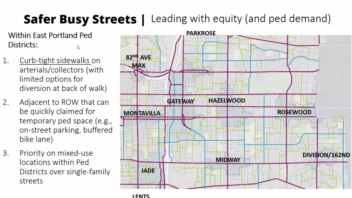
PBOT gave a hint to what these wider sidewalks will look like and said they’re inspired by what they’ve seen in New York City.

When it comes to expanding business space, Falbo said the agency is creating a “toolkit of interventions” they can offer businesses to help them adapt to a re-opening of retail services along with distancing guidelines. “We want to make sure they can use the curb zone to prioritize their needs.”

“We’re envisioning a broad array of potential business-serving uses in the right-of-way itself,” Falbo shared. “It might be in the parking lane (like the Street Seats program), but we also want to think big about what it means to take over half or full streets to create the plazas to let businesses spill into the streets and give people the space they need.”
Yes you read that right. More robust driving restrictions could be in the future as PBOT looks to squeeze every ounce of potential from our public street space. Below is a slide of their outdoor dining and other business-centric proposals. (Note: The presence of drivers and their cars in this image is troubling. PBOT might underestimate how incompatible these human-centric street uses are with the presence of loud, smelly, anti-social and scary motorized vehicles are. A similar illustration released yesterday by NACTO showed bikers and walkers, not car drivers.)

Advertisement
During a Q & A session, Falbo answered a question about the long-term potential of these proposals that I found very compelling. Here’s his full answer, which I think gives us valuable insight into where PBOT’s priorities are:
“If today, the focus is using that curb zone for a place to stand while you wait for your pizza to be made so you can pick it up and take it home, that’s using it for the condition we’re in now. But as we reopen restaurants and come back into the street and restart public life, maybe that space turns into street seats so you can eat that pizza while keeping a distance from the people at the table next to you. Then as we emerge from that and don’t need to keep that same distance anymore, I would hope these businesses can see the appeal of having more space for more customers and maybe those become permanent streetscape installations. And then as part of a future streetscape project we turn that into a curb extension that formalizes that public space.”
“How can you justify this expense when you’re asking other divisions to cut back?”— Douglas Armstrong, Budget Advisory Committee member
Falbo described PBOT’s approach as a “Pipeline to a better future.” “We can’t say that’s where we’re going to be,” he said. “But if we can do everything right and support our communities that might be where we end up.”
It wasn’t all roses and unicorns at the meeting. Advisory committee member Douglas Armstrong who represents the East Portland Land Use and Transportation Committee demanded to know how PBOT could pay for these proposals when so much of the city still lacks basic infrastructure. “I’m right there with you when it comes to public safety and having streets be as safe as possible,” Armstrong said. “But we have core issues that need to be addressed before we start adding bells and whistles on additional programs. How can you justify this expense when you’re asking other divisions to cut back?”
Pearce stepped in to defend the work: “We may be coming from a different place of seeing the urgency of this. I see this as part of the critical work our staff is doing… I don’t see this as an either/or transaction. One of the critical things is economic recovery.” And even PBOT Director Chris Warner chimed in to add even more weight to PBOT’s plans. “This is something we feel we need to do and we have council support to do it.” So far PBOT has spent $100,000 on the barricade installations and additional funding is coming from existing operating revenue. Federal Covid-19 stimulus grants are also likely to be part of the funding equation.
Adding to PBOT’s urgency is their sense that very few Portlanders will go back to taking transit, which means they must make streets work more efficiently — something that’s impossible when they’re clogged with single-occupancy car drivers. “We anticipate transit to be highly compromised over the next period of time because [of physical distancing requirements] we can’t fit a lot of people on buses or the MAX and we’re not sure what type of public sentiment there will be toward riding transit,” Falbo said. “So how do we make sure that a significant portion of Portlanders that use transit to get around don’t just shift to driving a personal car? That would be a bad move when it comes to VMT [vehicle miles traveled], carbon emissions, and safety.”
One way to ensure fewer people drive is to make other options more attractive. If PBOT is able to transfer street space away from the behavior that’s least supported by our adopted plans and goals and toward things like equitable and sustainable mobility and commerce that benefits local businesses, we just might emerge from this in a better place.
— Jonathan Maus: (503) 706-8804, @jonathan_maus on Twitter and jonathan@bikeportland.org
— Get our headlines delivered to your inbox.
— Support this independent community media outlet with a one-time contribution or monthly subscription.


Thanks for reading.
BikePortland has served this community with independent community journalism since 2005. We rely on subscriptions from readers like you to survive. Your financial support is vital in keeping this valuable resource alive and well.
Please subscribe today to strengthen and expand our work.
This should get interesting and comical as time goes by. I know for myself, I will have little interest wanting to sit in the street for a nice dinner. Maybe the do gooder downtown somewhere think differently. Don’t we think it odd that somehow restaurants think the same old idea is going to work? Will the city now become landlords and demand payment for the new use of the sidewalk and street? And what makes the city think that restaurants can afford their current rent?
And yes, our friend from East Portland is correct. We still need basic infrastructure that the silly folks from downtown won’t give us. Meanwhile, we come downtown and see over infrastured elements and wonder why the excess when we know of a bazillion places that could actually use it. One prime example is the jobs that Gabe Graff has been overseeing. He must have a money tree in his office.
Enjoy that $20 pub burger on a brioche bun while the aroma of a nearby homeless camp fills the air. Keep it weird Portland.
Classic Marxian wedge (not sure whether you meant that or not). My guess is that Doug H isn’t bourgeoisie, but is closer to the proletariat that own and operate the pub, grill the burger, serve it, and even those in the camp.
Is there another way to bridge the gap rather than to wedge it apart? One that still incents the owner to run a pub, the cook and server to do their part, the destitute to get their basic needs, and for Doug to still get a good burger. What is it?
Sorry my English is not so good. My comment was not directed as a personal attack on Doug at all. Sorry it was taken that way.
“ Will the city now become landlords and demand payment for the new use of the sidewalk and street?“
Why start now, after all this time providing free vehicle storage In that same public space?
I hope they don’t, as I’ve been leasing out the spot near me to my neighbor. I’d hate to have to give the city a cut.
Right now, people parking their cars are doing nothing wrong. It’s a public policy to provide street parking, and not all of it is free. Quite a bit of city revenue comes from parking fees.
Nothing is preventing you from using the same space if you want to. Don’t like it? Change the policy.
Ever been to Europe?
I’ll be honest – I’m not sure to whom these remarks are directed or what point they’re intended to make.
It’s possible that the younger generation is less sensitive to these factors. I say that, because I see townhouses being built with their decks overlooking heavily trafficked streets. A lot of people have grown up recently in a traffic-intense milieu.
Allowing outdoor commercial uses in street space doesn’t mean the City can’t keep investing in basic street improvements in East Portland. Different things with different funding.
Keep in mind that concerns about street commerce amounting to “privatization” of public space is a very American concept. In much of the world – whether Lagos, Bogota or Mumbai – street commerce and street markets are a core part of the vibrancy of public places. What is public and what is commerce is not mutually exclusive.
Since East Portland has so many parking lots in its commercial areas (think strip malls…), outdoor commercial activity can readily happen on repurposed parking lots. Businesses in inner neighborhood main street commercial areas often don’t have parking lots, so outdoor commerce needed to allow physical distancing will need to take place in street space. I’m glad PBOT is on board with repurposing street space to meet more community needs.
Not at all a bad idea to retake public right-of-way dedicated to automobile usage, but let’s look at some realities of implementation instead of general platitudes that don’t make much sense. What other business uses do they propose than restaurants? How viable is it for restaurants anyway, given short annual period of reliably decent weather that people would want to spend eating outside without a roof over their heads? And, how pleasant or safe will it be to be sitting at a table with cars mere feet from you, trying to enjoy that steak frites avec échappement de voiture? More likely the best use is simply more space for pedestrians to walk past each other with sufficient physical distancing. That’s not as politically palatable as trying to say that it will somehow save businesses, but it’s also not half as honest. In the age of COVID, it seems economy-washing is the new greenwashing.
I had the same thought about dining in the street. What strikes me as more appealing is dining on the sidewalk with pedestrians relocated to the street, similar to the current approach in Ankeny Alley.
In Europe and much of the US, they have these huge umbrella-like awnings for both the hot midday sun and for rain, at the center of large heavy-duty metal outdoor tables, designed specifically for such a purpose. They even have outdoor fans for the hot summer and heaters in winter. In DC, Raleigh, Charlottesville VA, and many other cities with large pedestrian malls, they are very popular with both locals and tourists, very profitable. As for the car traffic, there are many things cities can do to aggressively slow drivers without impeding emergency access, including removing one-way streets, narrowing lanes, adding impediments such as potted trees, adding frequent pedestrian islands, funneling transit buses, etc.
Retractable bollards, too.
In addition to restaurants, brewpubs, and bars on the street, there’s usually a lot of kiosks that you typically find in a shopping mall. In fact, what’s being created here is basically a replication of what you would likely find at an indoor shopping mall, but now outside and in the public right-of-way: retail clothing on racks outside, discount books, test riding of bicycles, food trucks, and transit stops. Given that we are talking about Portland here, I’m sure there will be issues with chop shops, homeless encampments, and political protests as well.
The whole idea of the indoor mall in America was to recreate the outdoor street life in Europe, but for a car-obsessed culture with no functioning city centers. (The guy who created the first ones was a Viennese architect named Victor Gruen). It would be great irony—and a fantastic idea!—that a copy of the copy of the classic form of European civic commerce comes closer to emulating it than the first copy did.
I agree sitting at tables in a former lane or parking space, separated from traffic by a few plastic wands, as shown in the PBOT drawings, doesn’t seem very appealing.
Here are a couple examples of dining in the street that seem more pleasant–one partially enclosed, the other much more so:
https://www.google.com/maps/@45.5151213,-122.6656057,3a,75y,46.05h,84.35t/data=!3m6!1e1!3m4!1s2uxozYSfsoSvmUP1Wl8Fgw!2e0!7i16384!8i8192
https://www.google.com/maps/@45.548491,-122.6755507,3a,75y,24.02h,83.74t/data=!3m6!1e1!3m4!1s59kF_uVFlL6NgnHfYQS8Gg!2e0!7i16384!8i8192
I like the notion, but it seems the more enclosed, the less point there is in having the seating be outside the restaurant. I realize there is a lot we still don’t know about how this virus is transmitted, but we do know that close proximity in a place with poor airflow contributes greatly.
Yes, certainly. I’m thinking those examples are more relevant for showing what might happen long-term. Having some structure, including elevating the floor up to sidewalk level, seems like it can create a pretty nice space that doesn’t feel like you’re eating in the street, and makes the sidewalk a nicer space to walk, especially compared to having tables on a sidewalk and making everyone walking squeeze by. I’ve seen better ones that incorporate planters, lights, etc.
I have mixed feelings about the Mississippi Pizza example, because it’s so enclosed and so long, and the sidewalk isn’t very wide, so it feels like you’re walking through the restaurant.
This is certainly the time to finally close off NW 13th to cars, PBOT”s effort to bring business to the streets is a perfect excuse to finally get this done. I don’t envy the restaurant employees on that strip as they climb up and down off the docks, but as a customer a car free 13th would be very inviting. Maybe they could even put up some trees and permanent infrastructure so some philistine does not try and bring back the autos after the virus is over.
I agree, NW 13th would be an ideal candidate, especially in the docks area from Davis to Lovejoy. Parts of NW 23rd might also work, as well as SE 2nd & 3rd from Yamhill to Burnside, and SE Stark from 78th to 82nd (make Washington 2-way).
Sorry to be so cynical, but when a planner says “We’ve gotten tremendous, positive response to this program,” it means that his or her planning colleagues love it, especially the others in the office sitting nearby. When a politician says they are getting pushback, it means that one or two major campaign donors are complaining. It goes without saying that neither type of person appreciates nor seeks input from public opinion polls.
The city loves what they did to NE Glisan in East county, meanwhile the people who have to live with overwhelming stated they didn’t want reduced lanes. The funny part is that the city shot themselves in the foot with the lane reductions because they would’ve been great candidates for Chloes Rose Lanes.
Honest question here: Do many folks in E Portland use Hawthorne as a primary route towards downtown? It doesn’t really connect to anything past the late 50s.
On the occasions I drove to work I used Hawthorne from 50th to SE 13th. Most of my commutes from outer east Portland were on my bike using Clinton west of 82nd, or Lincoln/Harrison west of the I-205 MUP. Salmon/Taylor was an another option. Very convenient for accessing businesses on Hawthorne, Belmont and Division.
Not very much, no. There was a study from the Bureau of Planning and Sustainability about 10 years ago that found workers in East Portland who worked outside of East Portland were the least likely to commute downtown, that the vast majority worked in the Columbia Corridor, Swan Island, East County, Clackamas, and Clark County. The study did not identify which routes they took, but traffic counts and congestion would indicate they were the most likely to use freeways and multi-lane roads for car driving, or else the MAX. Some of the busiest bus routes in the metro area are in East Portland, but again not going downtown, but to industrial districts.
Bicycling is a different matter. When we did our annual “breakfast on the bridge” event at the 205 path at Burnside, we found that there were almost as many bike commuters going east from inner Portland as those heading downtown, but also more than a few going from south to north. We know from counts that the Springwater is popular for going downtown, but so is Burnside/Everett/Ankeny, Division & 4M into Harrison/Lincoln, Bush/Woodward/Clinton, and the T-HOP.
It’s so sad we don’t value our MUPs here anymore.
I’d also wonder what days. I don’t see it being a commuter path on weekends.
Doug, NE Glisan from I-205 to Gresham has some of the lowest bus ridership in the city, so Rose Lanes would have been useless on that route. This shouldn’t surprise anyone – it’s a low-density area and within a quarter-mile of the MAX blue line. When East Portland Action Plan conducted an all-households survey in 2012, most of those who responded overwhelmingly wanted more pedestrian crossings, speed reduction, and safer bicycle facilities on Glisan, Stark, Division, and pretty much all the other major multi-lane arterial roadways. But yeah, you are right, East Portland residents also wanted freeways everywhere, as long as they were no closer than a half-mile from where they lived. East Portlanders are like everyone else, they want the best of all impossible worlds.
Oh, please. The 25 doesn’t need dedicated lanes.
Until we find the courage to start closing streets, this is not going to be much of anything. Cities are doing it all over Europe and I don’t want to hear the “but Europe is different than the US” excuse. I grew up in Belgium and I can tell you people LOVE their cars as much as anybody here in the US. About 10 years ago, local politicians decided it was time to close a huge chunk of downtown Brussels to traffic. Let me tell you that it took some courage because the whining from drivers went on and on and on, the same “the sky is falling” complaining you would expect here as well. But at the end they did it. I keep hearing “but we are different, it won’t work here” from people in the US and really it is just an excuse to do nothing.
Here is an example of a section that was closed. It is a 360 picture that was taken in 2017, so about 2 years after the street closure. At that time the city had installed quick moveable planters, etc. to make the space more appealing: https://bit.ly/2WYBpAm
Here is the same place in 2009 when it was a main road running accross the west side of downtown: https://bit.ly/2zhv5uZ — the difference is striking to say the least.
Here is the same place in 2019 when work started on the permanent streetscape, so it looks a bit sad, but now the permanent work is done (no pic of that I can find yet): https://bit.ly/2AOZpx8
Here is a video showing the full project including a rendering of the same area after completion (you get to that same area at about 45 seconds in the video): https://youtu.be/DmUGqAnVqTg
The bottom line is that the same model can be implemented here. We don’t need to be able to drive through downtown. We should be able to get to it from every side of course, but we should not be able to drive through it. And I am talking a few block around Pioneer square for instance and clearly also along the Park blocks. That’s how most European cities are doing it and again I really do not see what excuse we have of not being able to do that here. And people are still able to drive in 99% of the city, and they have come to realise it’s really not such a big deal.
I really feel like Brussels is a great example because even by European standards Belgium is particularly car loving. One reason is that there are tax incentives for employers to provide cars as a tax-free benefit, so there is a strong car culture.
I can tell you that 20 years ago what is happening now in Brussels was absolutely unthinkable, and people were saying “it will never happen” and yet people made it happen. But it took the courage to not listen to the naysayers and keep going.
So how do we make this happen here in Portland in the next 10-20 years or so?
I think a large part of why this is harder in Portland than many other places comes down to very poor city planning. Many roads in downtown are not just local streets, but through routes to get from one side to the other. For example, to get from the Central Eastside to US 26, the only viable route for cars is to go over the Hawthorne or Morrison bridges, then take 3rd Avenue or Broadway to Jefferson or Clay Streets.
In the vast majority of other cities there are easy bypasses of downtown to avoid this, making it significantly more feasible to closing the downtown streets. Frankly, whoever designed the road network around the area knew nothing about sustainable city design, and it would be a massive, expensive undertaking to fix this.
That being said, I feel that there are definitely some streets that are low-hanging fruit in downtown that could be closed with no disruption to anyone. I’m looking at Yamhill, Morrison, 5th, 6th, 1st north of Main, Pine/Ash, and Park/9th to name a few that I think this concept could be trialed on.
Our “easy bypass” of the central city is the I-5/I-405 freeway loop, also a viable option for someone in the central eastside looking to access US 26 without touching a downtown street (Morrison (W) > I-5(N) > I-405(S) > US 26(E)). And much of the day, this is faster. And even when it’s not, we should be encouraging traffic to do this rather than go through the central city on surface streets. So we’ve got alternatives and closing a few downtown streets to traffic like we’re talking about could help push people to use them.
Thanks, I had totally forgotten about the ramp from Morrison to I-5 northbound, and that does kinda refute my central point. I will always admit when I’m shown to be in error 🙂
I admire and strive for your same disposition on being wrong, .
That we already have these alternatives to go around rather than through the central city should make us question why the city hasn’t been more aggressive in using right of way space differently.
Yes Brussels’s equivalent to Portland I-5/I-405 loop is the “little belt” or small ring https://en.wikipedia.org/wiki/Small_ring_(Brussels)
Similar in size: https://imgur.com/gallery/ydGDVAW
Also similarly clogged with traffic at all hours, but that’s another problem and doesn’t justify why cars should clog all of downtown as well which (in Brussels at least) you can’t do any more.
I do think US cities are different from European cities in the sense that we have many downtowns. I have lived in a city in France that is similar in population (a bit smaller) to Portland, and the entire area of what would be considered the classic European style downtown is roughly the same area as NW Portland + the Pearl (Willamette to NW 23rd, Thurman to Burnside ~ish). This downtown area has many distinct neighborhoods that for us would cover only several city blocks. In Portland, we have a lot of well defined neighborhoods that have their own downtown sections (which are larger in size and much further apart than european central city neighborhoods), and I think it would also be helpful for car access and parking to be restricted to some degree within each neighborhood downtown, and to have car transport be focused on traveling between the neighborhood edges. Something akin to leaving your car on the periphery of these neighborhood downtown sections, and also working to improve transit between our defined neighborhoods.
Comparing cities is hard. Here is a google map montage I made of downtown Portland and downtown Brussels on the same scale: https://imgur.com/gallery/ydGDVAW
For brussels, the historic downtown has that pentagon shape that comes from the old medieval walls (shape of the inner circle road today).
Size wise, I feel Portland and Brussels are actually in the same second-tier category when looking at both cities as a whole, meaning the actual urbanized areas (not just internal administrative boundaries). It would be interesting to make maps of cities at the same scale that highlight urban core vs peri-urban areas vs suburban area. The caveat being that yes overall there is more density in European cities than American ones, but might just be a matter of age – Portland is still growing rapidly more like a teenager.
Brussels metro (including it’s suburbs) and Portland Metro (again with suburbs) are probably similar at around 2.5 millions. Of course in Europe we don’t have a US-type Metro definition because if you follow that logic Brussels metro ends up covering 60% of Belgium. If you focus on the urban+peri-urban core, Brussels is at about 1.2 millions. Portland city proper is only 650K but the peri-urban area expands further into Gresham, Milwaukee and even Vancouver, so I don’t think we are far from that number considering Portland Metro area is considered 2.5 millions. Here again it is a matter of agreeing on how we define urban vs peri-urban vs suburban of course.
Comparing cities is hard but I think that at least we can agree that Portland and Brussels and one notch down from the big cities likes London, Paris, San Francisco, New York, Seattle, Chicago, etc.
In general, American cities certainly tend to have larger suburban areas compared to their European counterparts. I feel that Portland is actually a bit of an exception, because its peri-urban area is quite large. On the east side in particular, it starts around SE 20th or so going all the way into Gresham with some suburban pockets in between for sure. South to Milwaukee and North into Vancouver. But yes with still a lower density that European style peri-urban for sure, but the grid structure points to a development in a peri-urban model different from the typical suburban areas. On the west side the hills create a barrier to the peri-urban expansion for sure and it looks definitely more like your typical American suburbs with a few peri-urban pockets. So all in all, to me, the east side is mostly peri-urban with suburban pockets and the west-side is mostly suburban with peri-urban pockets. That’s how I see it at least, but of course this is just my personal observation.
Portand is known as a city of neighborhood and that is actually very much how European cities are built. Brussels is internally made up of 19 official municipalities with the bigger ones further divided in neighborhoods. Note that Belgium uses a different terminology, so the equivalent of our city here is actually officially called the “Brussels-Capital Region’. When people just say Brussels, that’s what they are referring to. One of the 19 municipalities is actually officially called ‘The City of Brussels’ and it covers the historical medieval city, roughly what would be downtown+close-in-NW Portland today. But today nobody thinks of that has being Brussels, it’s just an official legal name. People just call it Downtown, old-town or center-town. The “region vs city” terminology is only because legally Brussels grew differently than Portland. The original medieval city didn’t change its boundaries but merged with the municipalities around it to create a bigger modern city (first officially called “agglomeration” then later “region”). Just as if the city of Portland had kept its as original boundaries (downtown) and a new entity had been created to merge what was then called East Portland (today called inner SE) + all the other town that were eventually annexed. Just semantics.
Bottom line, yes Brussels is made up of many neighborhoods all the way out with their own commercial areas, some more urban, some more peri-urban similar to Portland Alphabet disctrict vs shades of urban/peri-urban east of the Willamette etc. But the old medieval city “pentagon” that you see at the center of the map is Brussels’ urban downtown just as our downtown is well our downtown (!), and this is where the most of the movement towards pedestrian access has been happening.
Those are all good points! Thanks for the administrative info about Brussels that is interesting. I looked on streetview at some of the other commercial areas you are talking about in the Brussels Capital Region and see what you are saying. What does travel look like for locals within the capital region? Would someone living in a neighborhood outside of downtown visit another neighborhood outside of downtown casually? Do tourists visit non-downtown neighborhoods?
I can only speak for my experience in Portland and the people I have met here, but it does seem to be common for both locals and tourists, for example for someone who lives in St John’s to visit Sellwood or Woodstock and vice versa (or pick any 2 neighborhoods here). I have no experience to say what this is like in Brussels so I don’t want to presume that, but that did seem to be a difference compared to where I lived, in Toulouse (except for maybe going to further out parks, gyms, and larger businesses that don’t fit downtown).
And I agree that is a good point about determining where urban changes to peri-urban to suburban. With neighborhoods downtown, I was thinking of something like this:
https://www.google.com/maps/place/Saint-Etienne,+31000+Toulouse,+France/@43.5977656,1.441827,16z/data=!4m5!3m4!1s0x12aebc84801e5a85:0xbc32d2a0d7587b6a!8m2!3d43.5983735!4d1.4495103
where it takes roughly 5-10 minutes walking to cross the whole neighborhood which is a part of the greater downtown area. But yeah maybe that’s not a reasonable comparison to what we call neighborhoods in the US.
To reword what I was trying to say, I am thinking of a place like Por Que No on Hawthorne that frequently has (had) long lines. I would be curious what percentage of the people there lived in the Hawthorne or adjacent neighborhoods, and how many people got there by walking, biking or transit. I was trying to say that we have a lot of areas outside of our main downtown that people work and visit frequently where the people living there are and will continue to be impacted by the car traffic and land dedicated to people outside the neighborhood. That is not to say that downtown isn’t important obviously. I would definitely be interested on your perspective on how locals travel in that fashion within the brussels capital region!
“Falbo said. ‘So how do we make sure that a significant portion of Portlanders that use transit to get around don’t just shift to driving a personal car?'”
And the answer is: _________________________.
That’s an important question. I’m a senior citizen who relied on mass transit for in city transportation. I do not bike- though I support programs to improve infrastucture for bicycles safety enhancement.
So my question to Mr. Falbo: If people, especially senior citizens like me, won’t use transit because it currently threatens our personal health, and don’t bike (and I won’t use a scooter), what suggestion does he have other than a personal car.
p.s. I walk or run 7-10 miles a day, so I am not adverse to walking.
Transit off-limits; walking only applicable for a subset of destinations (depending on where one lives and if/when walking is an option); a populace not used to cycling to work (or using other personal mobility devices) en masse; driving expensive (especially for those who don’t yet own a vehicle), dangerous, and environmentally deleterious but (perhaps wrongly) perceived as virologically safe puts us in quite a pickle as to what mode to lean on.
A good place to start is focusing on reducing the need to travel altogether.
Continue to bring services and goods to people to the extent possible if those things are beyond a walk’s reach. For those fortunate enough, keep as many people working from home as possible once things open again. Work now with employers and employees to figure out what is and isn’t working and help bridge the gap; broad access to a high quality internet connection is the infrastructure our working from home “mode” needs to be widespread after the option to meet in person returns.
As for which modes to lean on:
Transit
Encourage people to leave the limited safe space available on transit for those who absolutely need to use it (essential workers, folks for whom other options are out of reach or comfort, for one reason or another) and continue to support transit financially as the lifeline it has proven to be (and always was) for all of us.
Walking
Supporting walking where it is geographically useful for reaching destinations is a no-brainer. Continue to expand and enhance the measures it sounds like the city is already cooking up re: safe space for physical distancing in and near business districts and local streets/greenways.
Biking
It would seem most people have some experience biking; Italy is leaning into that, subsidizing 70% of the cost of a new bicycle for every citizen living in a large city. Something similar here (maybe expanded to include any (electric) personal mobility device?) combined with an education + encouragement program and guerrilla rollout of any bike network elements we have planned (looking at you, Central City In Motion) could create the right incentives and environment we can recover into where people staying away from transit have an alternative to driving.
Driving is going to increasingly feel like the safest option, COVID-wise as you have nearly complete control of who you interact with while traveling (not considering whether a car can take you places where COVID spreads farther and faster…). It’s a difficult time to try to shoo people away from driving, especially if we don’t have great alternatives for them to consider. At the same time, everyone can acknowledge that for the foreseeable future, normal is suspended. People driving may be more receptive to messaging and measures that encourage and require them to be slower, safer, and more conscientious—I’m talking traffic calming, diversion, lane reductions—all of which can fall under the umbrella of supporting recovery from COVID-19. As in normal times, driving should be preserved for those who need to but must be balanced with other imperatives, namely everyone else’s right to safe access and clean air to breathe.
I might be missing something, but it doesn’t seem there is a magic new mode for seniors not looking or able to walk, take transit, bicycle, or drive (taxi/Lyft/Uber?); perhaps Mr. Falbo will materialize and share some additional insights! As in normal times, finding a way to make each one of those travel options useful for those who need them when they need them (while tilting the table aggressively in favor of those ways of travel we need more of) is probably the best way forward.
My gut feeling is that for this to work, they should fully commit and conctrate the effort on where it can thrive. I don’t think, as many comments here sugest, that putting some isolated tables in a lane for half a block next to traffic is going to do much for customers or businesses. Where I see this working is where they fully convert a stretch of street. And while it obviously won’t benefit all businesses, this seems viable and most useful in concentrated commercial clusters.
For example, I live in St Johns. Rather than leaving each business to ask for some space, I’d fully close Lombard in the business core. Every business–bar, restaurant, shop, barber–can have some space, with room leftover for pedestrians and bikes. There would be no traffic intermixed, and there’s an easy bypass route for car traffic on Ivanhoe (some crossings at Lombard would probably be needed). Clearly it wouldn’t work everywhere, but I think trying to make it work everywhere will distract from where the program can be a resounding success.
For this to be successful, it will require a sea change in how Americans accept walking or biking to a local destination. My impression, nothing more, is that ‘most’ Americans will walk half a mile, maybe a mile max to go to a nearby restaurant, business, etc. I base this on the number of people that I actually see walking beyond that perimeter, and the massive parking in nearby neighborhoods. Especially in ‘bad’ weather, or with kids in tow, it is a challenge for many. Over here in Bend, walking in 20 degree weather, with snow on the ground, and no sidewalks, is not for the faint of heart. A useful study would be to survey a couple of businesses, and ask ‘how far away do you live’ and would you be willing to walk, or ride a bike, particularly in adverse weather?’ Our laziness cannot be underestimated.
I agree on all counts. I grew up in rural Alaska, where we experienced brutal winter weather. I think some folks who have not lived outside of the Portland metro region, or in areas that do not experience severe winter (or summer) weather, tend to generalize and make assumptions.
FWIW, I’d take a year of Alaska weather to the year of Monroe, LA weather my family experienced in the mid-90s.
I heard NE 28th cannot be transformed because it is an emergency route of some kind. Several restaurants/ bars on that street. Ya, and I’ve been to Europe several times; the vast majority of their outdoor seatings are in plazas (all ped. except for delivery/ emergency) while most drivers drive like maniacs. I would never sit by the street here or there.
Fun fact: closing a street turns it into a “plaza”.
Seems like SF CA is already considering this: https://www.sfgate.com/food/article/Mayor-London-Breed-Shared-Spaces-Program-SF-food-15295719.php