
Portland Transportation Director Leah Treat’s decision last year to make physical separation the default design for bike lane projects is starting to pay off.

(Photo: J. Maus/BikePortland)
Portland Bicycle Planning Coordinator Roger Geller on Tuesday shared no less than nine projects, all approved and to some extent funded, that will scatter new, modern protected bike lanes into every quadrant of the city within two years.
None of them is a complete corridor treatment that runs longer than several blocks (though potentially larger projects in the central city and East Portland would be funded by the gas tax package that voters will decide on next week). And while they include some physical protection, they also include a lot of paint. Geller says that’s because the budget still isn’t where it needs to be. “We’re still operating on a budget that relies on shoestrings, hence a lot of color,” is how he put it last night.
But even so, if built, these projects will prove the city has taken a major step forward in its day-to-day process of planning incremental bike infrastructure improvements.
Geller presented the nine projects, along with several others that won’t include physical separation, to the Portland Bicycle Advisory Committee (BAC) Tuesday night. He also spoke with us by phone to briefly elaborate on each.
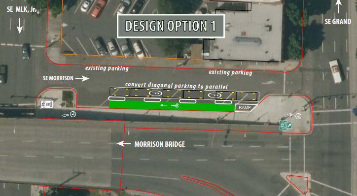
SE Morrison between MLK and Grand – construction this summer
The Morrison Bridge has a great bike facility that is almost impossible to reach, let alone find for the first time. With public bike share arriving in July, this proposal for a contraflow lane on SE Morrison Street would help people find their way to and from the bridge landing on Water Street. Both create a parking-protected westbound bike lane on this awkward stretch of road, a definite improvement for people looking to jump quickly between the Central Eastside and downtown. Geller floated two possible options to the BAC Tuesday night:

SW Beaverton-Hillsdale Highway, 35th-39th – construction late fall 2016
This is just a four-block stretch of a very important road, but Geller said upgrading it from a buffered bike lane to a post-protected one will demonstrate “the design that we want to continue with” as more parts of the roadway are repaved or reworked. Also note that PBOT is proposing a shared bike/walk lane because this section of the highway has no sidewalk. Asked about this last night he said the sight lines are good and he expects people to use the lane with courtesy. Here’s a basic before-and-after:

NE 21st Avenue bridge – construction starts 2017
Today, this bridge is arguably the most comfortable crossing of Interstate 84 in inner Northeast, but that’s not saying much. A planned redesign would remove a few parking spaces on each side of the bridge, upgrade and extend the southbound bike lane with a buffer and upgrade the northbound bike lane into a bidirectional protected bike lane — meaning, yes, you will be able to cross the bridge southbound using whichever side of the bridge you want.
Here’s the proposed north landing of the bridge:

And the proposed south landing:

Geller said the two-way bike lane on the east side of the bridge (the one that heads north today) will have some sort of vertical separation, possibly hard plastic posts.
“We’re going to put something in there,” Geller said. “We’re not yet sure what it will be, but it might be like the treatment on the Hawthorne Bridge. We’re looking at that.”
As for the interesting new “circular bikeway intersection” just beneath the Y of the southern landing, Geller said the center of the little roundabout “might be a painted element, it might be a raised element.” Whatever it is, it’ll be the first of its kind in Portland.
Also worth noting that the southern end of this project — the southbound curve on 20th — is where activists placed traffic cones to create protection for the bike lane back in March.
N Lombard at Pier Park – construction ends April 2017
This stretch of Lombard, a bit north of downtown St. Johns, is a useful connection to the parks and trails that meet at the tip of the St Johns peninsula. Geller said a series of restriped segments on Lombard and Burgard (which is what Lombard is briefly called when it jogs east to meet Columbia Boulevard) could combine to greatly improve access to Kelley Point Park, creating a bidirectional protected bikeway on the east side of the street that could potentially transition to a shared path.
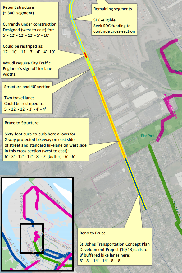
This seems to be one of the less detailed plans so far, but Geller is right that there’s room to do something.
NE Halsey-Weidler in Gateway – construction 2017
We reported yesterday that the upgraded parking-and-curb-protected bike lanes in this commercial district, the only sidewalk-facing commercial strip in East Portland, will be among the best in the city. Geller uses that language, too. His plan for the area reveals some new details, including a bike-specific traffic signal phase at the busy 102nd Avenue intersection:

Geller said this course change for Halsey-Weidler was a “direct result” of the memo Treat issued last fall, telling the city to assume that every new bike lane should be protected and only downgrade it to paint if necessary.
Advertisement
NE 47th, Columbia to Cornfoot – construction 2017
This project links one of the few crossings of Northeast Lombard Street with the Columbia Corridor industrial area and, intriguingly, Portland International Airport. It’s also a connection to Whitaker Ponds Nature Park, which sits just north of Columbia Boulevard.
The plan is to have sidewalk-level green bike lanes separated from auto traffic by a planting strip:

Nearby property owners, including the city parks bureau, are contributing to a voluntary local improvement district to pay for these changes to 47th. Unfortunately, the overpass that connects this stretch to 42nd Avenue and Northeast Portland’s residential neighborhoods is still pretty awful. This work won’t really pay off until that link can be closed.
NW Thurman and 20th – construction starts late 2017
Redevelopment of the huge Con-way site in Slabtown — haven’t heard much about the Slabtown neighborhood? you will — is leading to a complete developer-funded rebuild of two streets in northwest Portland. There’s more to see in the full plan, but here’s the most interesting section:

With the notable exception of the eight-lane freeway overhead, the design here is practically Dutch: raised bike lanes on 20th, protected intersections, raised crosswalks and even one block of a biking-walking street between 19th and 20th, beneath U.S. Highway 30. North of the freeway, a new bidirectional protected bike lane will connect west to 21st and 22nd avenues, which are proposed to get a new bike lane couplet.
Obviously this intersection won’t be truly human-friendly as long as the freeway is looming and roaring above. But for better or worse, Portland’s housing shortage has turned this into prime real estate anyway. That’s given the city a chance to make the space dramatically better for getting around without a car. At the BAC meeting last night Geller was frank about the lack of quality bike infrastructure in northwest: “We should see more biking in this area but we don’t, and I think that’s probably more of a failure of our facilities than anything.”
SW Bond Avenue – construction 2018
This will be a newly built street in the South Waterfront, running through the middle of the former shipyard between Moody Avenue and the Willamette River, connecting to the unfinished intersection on the west landing of Tilikum Crossing. When we got a look at the plans in September, we reported that as of that spring, the city was still preparing plans that showed a door-zone bike lane here.
No more. Thanks to the Treat memo issued in October, the city and the site’s developers changed course on Bond and are now planning a much more comfortable raised bike facility:
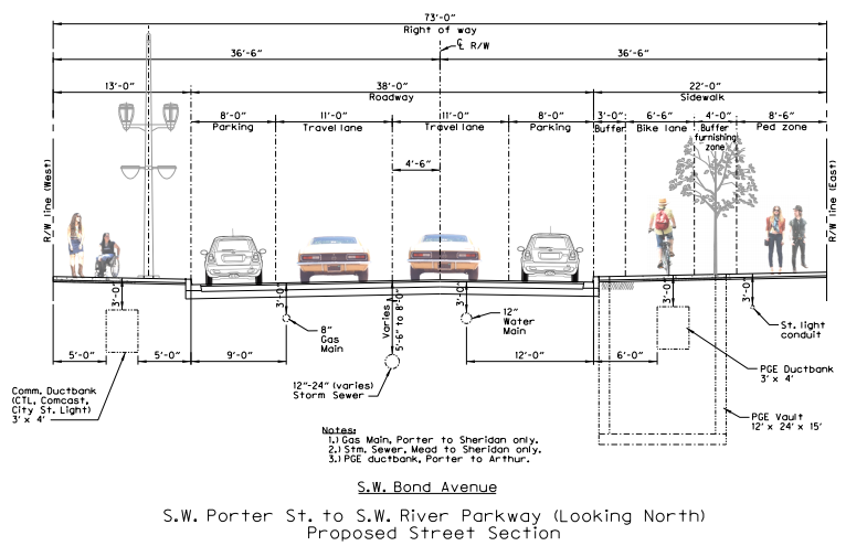
“Director Treat said we’re going to start with a protected facility,” Geller told BAC members last night. “In the past we’d look at the standard treatment of bike lanes and try to work our way up to something better; but when you start with a protected bike lane and you’re directed to do that, you get different results.”
In the past, the city has rightly worried about whether sidewalk-level bike facilities invite conflicts between people walking and biking. But Geller said the solid green color installed on Moody Avenue last fall is working much better than the previous uncolored sidewalk-level bike lanes.
“This design that we have finally implemented on Moody is working really well for road users,” Geller said. “I think we also saw in the Massachusetts Department of Transportation Separated Bike Lane Planning and design guide, they had some really good images that clearly showed a really strong visual separation. I think that also reinforced our experience.”
SW Burnside-Alder-19th-18th – construction TBD
We broke the news in February that the city was considering adding protected and buffered bike lanes, plus protected intersection elements, to this hectic triangle of pavement. Geller shared the rendering from local consultants Kittelson and Associates:

You can read more about this project in February’s coverage. It’s great to see the protected intersection concept (which had also been floated in some pro bono work by local street designer Nick Falbo, who coined the “protected intersection” phase) continuing to move forward.
After Geller had gone through each of these projects, I asked him whether they represented a breakthrough for the city’s internal assumptions about protected bike lanes: for example, the fire department rules that prevented the lanes on Stark and Oak downtown from being parking-protected, or concerns about keeping them clear of snow or debris. (The Oregon Department of Transportation has floated that a few times as an obstacle to protected bike lanes.)
Not really, Geller said. Those obstacles aren’t any larger or smaller than they were before.
“The Fire Bureau wants 20 feet [minimum open roadway width] and that hasn’t really come up in these particular designs,” Geller said. “I think we’re going to have to continue to work out maintenance on these. We may need some new equipment.”
“The bureau is focused on problem-solving those issues as they come up,” added city spokeswoman Hannah Schafer.
Geller is, however, optimistic about new collaboration with the Bureau of Environmental Services, which is often looking for chances to add permeable rain gardens to city streets. Geller said a closer relationship with BES might let the city turn storm-runoff strips into protection between bike and car traffic.
“We recently did an in-house exercise with them and I think we’ve got some good opportunities to do some new techniques,” Geller said. “Certainly as we get into the central city project, that will come into play.”
PBOT has several other projects in the hopper that will improve bicycle access at key locations throughout the city. Stay tuned for a look at bikeway improvements coming to NE 37th and Prescott, NE 122nd and I-84, NE 16th near Sandy and SE 41st and Holgate.
— Michael Andersen, (503) 333-7824 – michael@bikeportland.org
Our work is supported by subscribers. Please become one today.


Thanks for reading.
BikePortland has served this community with independent community journalism since 2005. We rely on subscriptions from readers like you to survive. Your financial support is vital in keeping this valuable resource alive and well.
Please subscribe today to strengthen and expand our work.
Huzzah. Really excited to see the 21st Avenue bridge project on the list. Now to remove one side of the parking on the stretch between Multnomah and Weidler and add some dedicated space for bikes.
SW Beaverton-Hillsdale Highway needs it between SW 30th to SW 39th. It has just one driveway on the north side of the highway and less than eight driveways on the south side. There is just one floating sidewalk in that space.
Excellent. I’m excited for those Lombard improvements! The new section of Lombard just north of N Terminal used to have a separated lane (during construction). I’m excited to see that return in a permanent fashion.
The improvements south along Lombard to Pier Park will be a great help as well. A few years ago, I was hit by a car while riding Lombard between Weyerhaeuser and Bruce (a block before Pier Park). It could have been worse, but I had an a-c joint separation, bruised ribs, and was pretty scraped up. Excited to see that be much less likely with these improvements.
The SE Morrison project is a ridiculous waste of money! The only way to get to it from the east is on a sidewalk that is already crowded with people, bus stops and cafe tables on Morrison or Grand, then it goes nowhere. This block has virtually zero traffic on it and needs nothing. Every other single thing about the Morrison bridge should be fixed before this! Shocking.
That Burnside project is fine for cars, an improvemtn for bikes but truly a travesty for people walking on the south side of Burnside! Shame on Geller for being overly bike-focused. A little bit of spine and creativity could solve this. The Alder sliplane should have been closed years ago, it is complete hazard to people walking.
The Burnside project is a massive improvement for pedestrians, including those walking on the south side of Burnside, but especially those crossing Burnside.
Maccoinich,
I really value your expertise, but I cannot see how this much of a win for peds. I would love to hear you expand on this a bit. There are additional crossings but they are long and out of direction. Peds get routed around bike intersections. High speed cornering from westbound Burnside on to Alder is preserved. There is no sidewalk along the west side of 18th. The sidewalk along Akder between 18th and 19th is really meager and sandwiched between cars and bikes, The bike lane is rudely slammed up against the Firemen’s Memorial. How about this:
-close the Alder sliplane from 19th to 18th.
– 18th 1-lane, one way from Morrison to Alder, forced right at Alder and close outlet to Burnside or continue to 90-degree intersection at Burnside- offset intersection with shorter crosswalks. Bike lane added, Sidewalk added on West side, no parking
-Burnside becomes 5 lanes from 21st to 14th )2 bike lanes, 2 travel lanes, center turn)
-Firemen’s Memorial Plaza Extended to Burnside.
– add parking along Burnside where 18th is proposed to be closed
-ditch the contra-flow bikelane on Aler.
Bearing in mind that these are conceptual diagrams, and not engineering drawings, wins for pedestrians include new crossings on the west side of 18th and east side of 19th. For many trips across Burnside that will mean pedestrians have to wait through one less light cycle. Alder is also going down to one car lane, meaning shorter crossing distances and slower car traffic. Looking at the drawings I can’t see any pedestrians journeys that would require more distance traveled, but I see plenty that would require less distance traveled. For people walking along the south side of Burnside the crossing distances will be a lot shorter.
I would love to see bike lanes on W Burnside as much as anyone, but there are some very real issues with that. There are only three major routes out of the Central City towards Washington County: the Sunset Highway; Burnside; and Cornell. All of these carry a lot of car traffic. Cutting vehicle capacity out of any of them would likely cause gridlock. If that doesn’t concern you, then think about the impact it would have on TriMet buses, including the 15 and 20.
Thanks for the thoughtful reply. You raise a great point about a reconfiguration of Burnside slowing Trimet. However, when they did a traffic analysis of the West Burnside, the Center turn lane very nearly compensated for the loss of travel lane so I am not terribly concerned. In terms of Pedestrian benefits: the additional crossings are nice but could be added to almost any scheme. We may simply have to to disagree about the pedestrian experience on the south side of Burnside. I spent quite a bit of time on this location and I am very familiar with how poorly it works for people walking. This proposal is basically status quo, and the status quo is horrible. Worse yet, doing this work all but guarantees that this will not be changed/improved for decades. Burnside is a very important transportation corridor, but it is also the very center of our city. It occupies a key place in nearly everyone’s mental map. Burnside should become a great street that functions for everyone. That flimsy, convoluted sidewalk is a disgrace.
Do you have a link to the analysis? I had heard the opposite: that a road diet on W Burnside would have huge traffic impacts. If that’s not the case I would be really interested to read the report.
And FWIW, I don’t come from a position of being indifferent to pedestrian concerns. I live near this location, and probably spend more time walking than I do cycling.
Since left turns are prohibited on most of West Burnside, how would a center turn lane make up for fewer traffic lanes? Seems to me a center turn lane would have no function at all, where you can’t make left turns.
Max,
You do recall the County owns most of the bridges, yes?
I am aware, what is your point?
“Every other single thing about the Morrison bridge should be fixed before this!” your quote.
Only, the city doesn’t usually spend Portland tax dollars on infrastructure Portland tax payers don’t even control.
I agree that Alder slip lane really needs to be made into a car-free space. Crossing that area on foot is really challenging. Though, I’d much rather cross a cycleway than a roadway, so IMO this is a huge improvement over current conditions.
I disagree. MaxD is spot on correct. Fundamentally I have a strong dislike of the so called ‘protected bike intersections’ because they are so pedestrian hostile, especially in pedestrian intensive areas like Adler/Burnside.
I know we disagree on the degree of ‘hostility’ introduced by this design, but it certainly changes the interactions between bicyclists and pedestrians.
If you want to see how it works, look at 8th ave in NYC. While this isn’t a full protected intersection corner, it does illustrate how pedestrians would interact with one. The two pedestrians standing in the islands seem to appreciate the reduced crossing distance it has provided.
I’ve lived two blocks from this intersection for nearly ten years and am thrilled to see the improvements. I use it almost daily as I cross Burnside to commute by MAX, by bike when riding South/North on the weekends, and occasionally by car.
I love the narrowing of 18th down to one lane. Cars tend to race up the hill and power through intersections at Couch, Davis, and Everett as it remains two lanes until you cross Everett and the bike lane begins. Not even the crosswalk at Couch and 18th is honored by many drivers. It’ll be a heck of a lot safer with cars feeling more constrained on those three blocks.
The sidewalk extensions are also going to help slow down traffic and reduce crossing distances. It’s too bad they weren’t called out better in the diagram as I think they’ll have a huge impact. Plus the new crossings are a big added bonus as I’ll likely be able to walk across on one light rather than two.
The sliplane on Alder actually does provide a really good purpose, as it’s one of the very few places you can make a controlled left turn on West Burnside. Sure there are a few side streets like Trinity where you can dart in, but not without backing up traffic or taking your life in your hands. This design appears to keep the lane but narrow it up to create a protected bike land and more parking.
One thing I’d like to see is a dedicated pedestrian crossing segment to the signal timing at 19th and Burnside. That seems to be the point of heaviest foot traffic, particularly on game days, and most cars want to turn right onto Burnside and I’ve seen more than a few close calls as drivers get impatient. Allowing pedestrians a dedicated crossing time, or maybe an early head start, would do a lot to get all users through the intersection faster and safer.
Apparently this is the sad, sad answer to my question about how you’d even get to that section of Morrison.
I’ve been asking PBOT for this Morrison gap closure since the block was rebuilt as part of the MLK/Grand streetcar project in 2011ish. It’s too bad this facility wasn’t a part of the design in the first place, but I’ll take it now. I used to work near there and would see cyclists stop at that intersection, confused about how to access the Morrison Bridge path, then give up and try riding the sidewalk on the viaduct, which of course leads to a stairwell underpass and the narrow side north sidewalk of the bridge, rather than the path on the south side. This project will fix that.
And yes, Morrison should have a cycle track approaching this intersection from the east. I expect eventually there will be some sort of bike facility on Morrison eastbound starting at SE 25th. That isn’t here yet, but when it arrives, this gap will already be fixed. Some progress is much better than no progress.
I was so excited to read this article about PBOT getting to work, but I am so disappointed in the quality of these solutions. The bi-directional bike lane on Lombard seems egregiously dangerous. traveling against the flow of traffic in such a skinny lane on that particular stretch is simply a mistake. Cross traffic turning right are already used to rolling through stop signs. This area has many times of the day/week when traffic is light, and bike traffic is frequently light. This plan puts bike riders in a super vulnerable position on the road. There would need to be an unprecedented amount of enforcement to make this design work. IS there an opportunity to weigh in on these? All of these areas (except the Morrison stretch) need improvements, but much of what I see here is expensive steps backward.
The 21st street bridge looks oddly thought out and it still keeps the worst part (in my opinion) – the merge on the South side of the bridge. Would it be that much extra work to get rid of the parking from the bridge to at least Ankeny and add protected bike lanes?
Also, if they’re going to be doing any structural work to the bridge, it would be swell if they could make the “crunch zone” of the curve a little wider for people walking and biking.
people who don’t want to merge on the south side can use the protected bike lane to get to Irving on a calmer sharrowed route.
In my case, if I’m heading South on 21st, I’m usually headed to 32nd and Ankeny.
Normally, I would merge onto 20th and keep up with traffic until Ankeny and then turn left. However, if I were to take Irving, I’d have the choice of 24th to Ankeny or Glisan to 32nd. In my experience, both of those options are much worse than my current route. Crossing Glisan at 24th is usually pretty bad. And riding on 32nd is difficult due to the aggressive drivers using it as a cut-through.
20th has lights that are timed pretty well for my biking, so it’s not much of an issue after the merge, but the merge is in a really bad position and most drivers don’t look out for bikes.
SE 16th is a Greenway, has OK connections, and is reasonably comfortable.
SE 22nd has a dedicated one way contra-flow bike lane (similar to SE 34th) and a good signal. Moreover, there is no need to cross Glisan southbound because the bike lane from SE 22nd continues up to 24th.
https://www.google.com/maps/place/NE+22nd+Ave+%26+NE+Irving+St,+Portland,+OR+97232/@45.5279079,-122.6434252,3a,60y,179.44h,79.5t/data=!3m6!1e1!3m4!1sFr1Zbow5890y0r_jlGfZ3w!2e0!7i13312!8i6656!4m13!1m7!3m6!1s0x5495a0b7876e1353:0x439ebf74ae8b9c83!2sNE+22nd+Ave+%26+NE+Irving+St,+Portland,+OR+97232!3b1!8m2!3d45.5279079!4d-122.6434252!3m4!1s0x5495a0b7876e1353:0x439ebf74ae8b9c83!8m2!3d45.5279079!4d-122.6434252!6m1!1e1
Improvements to SE 20th represent a much larger, more difficult, and far more controversial project. The space allocated for bikes on 21st would work well with a future protected bike lane on 20th (when there is funding for that project).
16th is a highway on-ramp that’s way too wide to be comfortable that doesn’t have a light to cross Burnside. 24th, 16th and 22nd all have the issue of crossing major streets without a light, which I’m not a fan of. People will deliberately attempt to scare me off the road by driving fast and close when I pedal across the crosswalk.
ethan, with all due respect i’m not convinced by your argument. riding in traffic on NE and SE 20th and then turning across impatient traffic at an unsignaled intersection (SE 20th and ankeny) seems far more risk-tolerant to me than carefully crossing burnside at 24th or 16th.
I will likely still use 20th because I am comfortable exiting the bike lane and riding in motorvehicle traffic. My partner, on the other hand, is uncomfortable on this route and prefers SE 16th. The comfortable route to Irving would be a huge improvement for her.
I think the bi-directional cycletrack (?) along the 21st Ave overpass is intended to facilitate travel to the one-way, bike-only lane on 22nd Ave which aids in crossing Sandy Blvd safely onto Glisan. I’ve been using this path lately with the purpose of ultimately connecting with 34th Ave after Belmont. To this end, I do believe the 21st Ave overpass modification will be helpful; however, I too would rather see parking eliminated along NE 20th Ave until Ankeney.
I’ve been lobbying for a bike facility on 20th for many years but the 21st project is being funded using a small project mechanism. It also allocates space for an eventual connection to a 20th protected bikeway*.
This sounds like progress. I hope PBOT soon realizes they need to design ramps, turns, and sightlines for 20mph+ bikes (including uphill, because electric), with space for 2 bikes abreast in each direction. Drivers get fast, efficient infrastructure and free parking so maybe we should try to make it so people can just as easily get somewhere on a bike? (Cue somebody claiming a biketown cannot get to 20mph.)
We’ll need more than “strong visual separation” to keep toddlers and puppies out of the bikeway. Too often, it sounds like the bikeway planning assumes this is recreational space rather than transportation corridors. Sometimes you need to get somewhere instead of pet a puppy.
The shared bike/ped space on BH highway is a start, but isn’t going to cut it in the long term. And, would that legally be a sidewalk or a bike lane, or one of each? (Because electric bike law, mandatory sidepath law, and driveway / intersection right-of-way laws are totally different in those two cases.) Seems like an important detail, yet when I ask this of PBOT they shrug at me?
“…electric bike law, mandatory sidepath law, and driveway / intersection right-of-way laws are totally different in those two cases.”
This is an excellent point. Will this section be re-branded as a MUP?
Some context for the Thurman and 20th project: right now drivers coming off the freeway and into the Con-way masterplan area turn left onto NW 23rd. As the area develops (construction is about to start on a 385 unit apartment project) a lot more cars will be using that intersection. As mitigation, the developers are paying to construct a traffic change that would route cars off the freeway onto NW Wilson, and then onto NW 20th. What makes the project expensive (over $4 million) is that NW 20th doesn’t currently extend underneath the freeway, and the lack of clearance means they have to excavate down a little. It’s mostly a project to benefit drivers, but the additional traffic it will bring means the protected bike lane / intersection treatment is well warranted.
The drawings look make it look like there will be some form of diverter at NW Raleigh, to stop cars traveling further down NW 20th. This is good, given that if the gas tax passes NW/SW 20th is meant to be upgraded to a neighborhood greenway all the way to the Goose Hollow MAX station. It will however also add more cars on NW Raleigh, which is barely functioning as a greenway as it is. Upgrading NW Pettygrove to greenway standards therefore becomes even more important.
The plan is for Savier to become a greenway, and so the proposed diverter location at Raleigh makes sense. With the signal at 23rd, and TriMet’s plans to run the #10 bus down that corridor, Raleigh is for all intents and purposes a collector street now.
I’ve heard talk of designating Savier as a greenway, but is that actually an official policy? Pettygrove is included in the Central City amendments to the TSP (Project #20163), but I don’t see Savier anywhere.
Central City is still only at the Discussion Draft stage…so stay tuned.
A “buffered bike lane” is not a “protected bike lane” unless there is some physical barrier between the bike and car traffic, such as parked cars, curb, planters, or concrete barriers. The project on 21st is a simple buffered bike lane, not at all “protected”. Lombard is not much better.
The protected bike lane is on the east side and PBOT is planning to use a plastic curb with flexible bollards a la the Hawthorne Bridge.
I most certainly would not be comfortable biking southbound over the 21st ave. bridge in the two-way cycle track without a truly solid separation – jersey barrier or better.
Seems to me there’s an unacceptably high risk of a head-on with distracted drivers – especially approaching the curve. Scary!! Please don’t provide a false sense of security by placing “something” – plastic bollards??
I keep coming back to distracted driving – it’s unbelievably pervasive. In engineering, we have “tolerances” to allow for non-perfect circumstances and still provide proper function. In too many PBOT projects the tolerances are too fine, IMO.
The biggest obstacle to overall improvement seems to remain the inability to really push back on automobile driving … and the sacrosanct [free] parking.
The same risk of collision exists today for northbound cyclists without any protection at all. IMO, southbound travel would be safer and more comfortable due to the bollarded plastic curb and because the cyclist could see oncoming traffic. Moreover, the protected bike lane curves away from traffic onto 21st court so I don’t see the curve on 21st as a major issue.
I am on record as being generally opposed to bidirectional protected bike lanes. I intensely dislike the ones in Vancouver, for example. However, on this bridge (absent improvements to 20th) this bidirectional lane makes a lot of sense. This is a creative and relatively inexpesnive solution that creates a comfortable route now and allocated space for a future protected facility on 20th*.
*hundreds of parking spaces would have to be removed and the facility would likely have to be a bidirectional protected bike lane due to space constraints between Stark and Morrison.
excuse the typos.
This is the type of separation Roger Geller mentioned:
https://www.flickr.com/photos/bikeportland/10215581923/
It’s a huge improvement over mere bollards.
It is a small improvement. The curb is mountable and the ‘bollards’ are the same as any other ‘flexible vertical delineators’.
a ~2 inch bolt-attached plastic curb with a dense thicket of flexible vertical delineators seems to me to be more effective than the ~2-3 inch curbs used in copenhagen.
we do not need jersey barriers everywhere.
I’d be happy with bioswales separating the cycleway from the roadway, similar to this cycleway at Naito and Lincoln.
Glad to see the city working on concrete plans for more protected cycleways. Most of these look great! Not so sure about the Morrison project though as it looks a bit confusing. Also, the bike roundabout on 21st looks too small to really be useful. Bikes can’t make that sharp of a turn and most people will just ride over it anyway. I hope that if the city feels they can’t afford a curb to use cheaper flexible bollards instead of just paint. Curbside buffered lanes are okay, but some sort of vertical separation would be better than paint. Then in the future, when the money is there, add the curb. The Thurman and 18th/19th projects look especially exciting!
Overall, glad to see the progress and happy that Director Treat is working on implementing her ideas. Looking forward to seeing these on the ground.
Also, I like these projects because given monetary constraints, I’d much rather see a project that doesn’t compromise the design but scales back the scope. For example, instead of 20 blocks of buffered bike lanes, do 10 blocks of protected ones. It’s much easier to go back and extend the facility later than it is to change the configuration again. These projects are small but don’t compromise the ideal design. Good work.
Another thing I’d like to see is for the projects that feature a raised cycle track next to the sidewalk, is for the sidewalk to be graded slightly higher than the cycleway to make it obvious which section is for bikes and which is for walking. This also helps visually-impaired people feel the curb. If the road is being reconstructed anyway, it shouldn’t add to the cost much.
This is a good point I should have asked about – thanks.
So very glad to see the Thurman St project. Right now, a cyclist heading west on NW Thurman (from east of 19th Ave) has to veer onto a side road that drops them on an off-ramp of Hwy 30, with the trucks and heavy car traffic exiting the freeway from the Vaughn St Exit, if they want to continue going straight. It’s not the best.
Ridden the section of N Lombard/ Burgard past Pier Park so many times. Desperately needed bike lane fill in for this gap as shown. Although, the low hanging fruit (Bruce to Structure) where there is loads of space and feeling safe while biking is never an issue, it’s the part shown in red and light green that need help – especially the 40′ bridge structure where the true pinch point is located and then the blue line that curves around which needs the SDC funds. The city recently worked on this area and put up 45 mph speed zone on a blind corner, on a bike lane gap, where heavy, constant truck traffic typically drive 10 mph higher than posted. City needs to work to not only add bike lane stripes, but also to control traffic speeds in what is a heavy trucking cooridor – especially around congestion, driveways, and blind corners. This area feels really dangerous, but doesn’t have to be if city would complete all the aspects of controlling traffic here, not just striping the lanes.
This works needs to go forward without further delay. They also need to close the gap on the only other way into this part of town, the Columbia Blvd section from Chimney park to Burgard. This is also a truck-speeding race track with a bike lane gap of 1/4 mile.
I’ll be glad about the Lombard improvements. Right now I avoid that whole stretch by taking the Columbia Blvd sidewalk to Chimney Park and across the bridge to Pier Park.
Yes, this way works and I usually take Columbia instead of Lombard to get from St Johns to Kelly Pt, but sidewalks on Columbia are not continuous.
City needs to fill in the short gaps in both these roads, so you can get out to Rivergate from St Johns by either way: Lombard/Burgard or Chimney Park/Columbia. Currently, both ways have about 1/4 mile gap of bike lanes.
It’s so great the city has so many plans for improvement, but I frequently feel I will be dead before any of them ever come around to fruition. More doing, less planning type of attitude could go a long way in city hall/PBOT.
More bikes hit the death zone on the West end of the Hawthorne Bridge (Westbound .
When will the city admit to one of the largest safety gaps in our network. These 9 projects are mild buffering, barely separated. Separate is when a drifting car can NOT hit you.
Our city leadership is still too silent on parking and diverters on greenways. And connecting to safe arterials.
People want to drive less and we are pushing them to drive with scattered projects all over town. Our 30 year plan sucks, the fact we will only imement 30% sucks too.
Are we really at 30%? Only about 12% of the bike infrastructure in my neighborhood is complete so far and in talking with local politicians, it seems like they will be stripping the most prominent bike routes from the plan and forcing circuitous routes for bikes instead of removing a small amount of redundant parking.
‘separate’ does not imply ‘protected’, but only ‘space’. Buffered is separate. Bike lane is separate space for bikes.
Buffered is not protected.
And while ‘barrier’ is a continuum, from zero (bike lane or buffer only) to 100% (a wall and landscape), the definition of ‘protected’ should include a barrier that at least slows transgressing drivers, like a 6 inch median at least two feet wide with non-mountable curbing. Narrower would only qualify if also higher.
I’m disappointed the Unipiper was removed from the plans for Bond Ave. When will PBOT get serious about diversity?
Ok, serious question though. Is the new Bond to be a 2-way road or 1-way? The old drawings showed 2-way, with the northbound lane including streetcar tracks. This new cross-section looks to be a one-way with no streetcar. Also, is the west sidewalk a shared sidewalk/bike path?
Bond is going to be one way northbound. The long term vision is for Moody and Bond to function as a couplet. Earlier plans called for moving the northbound streetcar over to Bond as well, but I think that has been abandoned. Once the full length of Bond is completed (which is still many years away) it’s possible that they’ll convert the northbound streetcar lane on Moody to transit only.
don’t entirely understand the effort to build a protected bike facility here on bond when you have two of the best in the US class bike routes a block away on the waterfront and moody. who would be using bond anyway?
does this also mean zidell is shutting their yard?
Zidell isn’t going anywhere (for now). The section of Bond that’s about to start construction is between the approach to the Tilikum Crossing and SW River Parkway. The reason for building it is now is that OHSU is close to breaking ground on another large building at their Schnitzer Campus. So the road is being built either way, whether or not it includes a protected bike lane. And given that the road is building built from scratch, why not make it protected? The cost difference is negligible. Even if they removed the bike lane entirely, which would be totally contrary to the area masterplan developed over 10 years ago, the street would only be 9′ narrower.
And to answer the question about who would use SW Bond: anybody cycling over the Tilikum Crossing and heading north would be able to do that without having to wait cross SW Moody. Given the need to wait for a green light at that intersection, that’s a small but important time saving that I think most people will wind up taking advantage of.
anyone can currently avoid multiple signals by cycling (safely) on the east-side sidewalk. if there were a cyclepath on bond i would no longer do this.
While I like these modest initiatives, the project timelines, costs, and distance covered highlight the challenges of putting in place physical separation. I’m very much an optimist when in comes to technology and believe effective virtual separation enabled by sensor ladened vehicles will arrive sooner than we think. Whether it’s keeping vehicles from crossing into bike lanes, or efficient routing of vehicles along designated arteries, virtual separation is the only practical way to deploy protection over a significant portion of our transportation infrastructure. It won’t be perfect, but it holds far more promise than physical barriers. Don’t read me wrong, I’m not trying to bash these efforts. I’m just reminding advocates for safety that it is important to look ahead and not focus entirely on solutions to yesterday’s problems.
The idea of mixing, albeit with a ? protected ? lane of travel for a few blocks on Lombard out to Kelley Point and Marine drive seems short of vision. Parks is working (slowly, IMHO) but working, to build that section of the npGreenway from the former SJ Landfill, with a funded bridge over Columbia Blvd ( another freight corridor) on to Chimney Park, over the recently dedicated rail overcrossing into Pier Park, passing thru PIer on a paved and very nice segment of trail onto N Bruce St and on to an at grade crossing at Lombard and then on neighborhood greenways to Cathedral Park. A far superior route connecting to Kelley Point and beyond, not only for those strong and fearless, but for the lower echelons of bike gentry. Flipping off the freight community seems short sighted: they have their work to do, and are not excited about the added risk of ‘separated bikeways ‘ on the official freight route to Rivergate and Marine drive.
Focus the energy on completing the Kelley Point to Cathedral segments.. low hanging fruit for Metro and Parks, owing to the large pieces of public land in the alignment. A ride in the park(s) is far preferable to sharing the road with 80k GVW trucks belching diesel.
Great job PBOT, but I’d much rather see a permanent, ada-compliant sidewalk on Beaverton-Hillsdale Hwy between 35th-39th than 45 seconds worth of Protected Bike Lane.
Fanno Creek is at the edge of the row. There is a 35 foot drop from the road to the creek. Straight down. A massive overhaul or transit and land use planning and complete streets would be needed before a possible BHH road diet. BHH needs a 30 mph speed limit.
The sidewalk would go on the other side.
The current Beaverton-Hillsdale situation is horrible–can hardly tell if it’s a bike lane or just a shoulder for many stretches. The proposed design is a great improvement. But at the same time, how sad that something that can be viewed as a great improvement is still so pathetic. A major route like that should have real sidewalks, and not force cyclists and pedestrians to share a still-narrow path with cars whizzing by at 40 mph 1.5′ away.
I’m not criticizing the improvement, just pointing out how low standards have been here for decades.
BH has a bike lane between Bertha / Capitol to SW 65th Ave, but the bike lane doesn’t return until for the west-bound section from SW 110th Ave to the southeast edge of the nearby big Fred Meyer (southbound 217 offramp). ODOT maintains BH from I think the Lombard railroad tracks to 65th Ave and they could restripe all of BH in that section in order to make some 3 foot bike lanes.