From barflies to neighborhood officials, most east Portlanders seem to agree on the highest-priority biking improvement for east Portland: a few really good neighborhood greenways.
Consensus has benefits. The 130s Greenway is scheduled to be built next fall, and the 100s and 150s greenways are in the works.

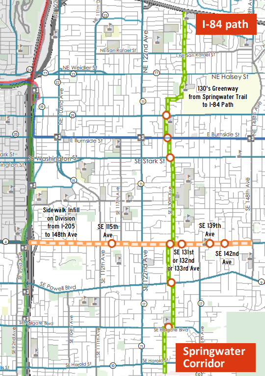
(Image courtesy City of Portland. Annotated by BikePortland.)
The 4.8-mile 130s route would connect the area’s best east-west paths by providing safe crossings at six major streets (SE Holgate, SE Powell, SE Division, SE Stark, E Burnside, and NE Glisan), city spokeswoman Diane Dulken wrote in an email Tuesday. It’ll zigzag along (from south to north) 128th Avenue; 130th Avenue; 131st, 132nd or 133rd Avenue; 130th Avenue; 129th Avenue; 128th Avenue; Pacific Street; 131st Place and 132nd Avenue.
Advertisement
Because almost all the side streets in this part of the city are offset from one another, it’ll require significant investment in short stretches that zag alongside major streets.
The project is funded by $1.3 million in mostly federal grants that were won after a political fight for cash led by the Bicycle Transportation Alliance and approved by Portland City Council in one of Sam Adams’ final acts as mayor.
Like other neighborhood greenways, the 130s would add speed bumps, directional signage and a 20 mph speed limit to the streets it designates. The city says traffic diverters won’t be needed because the offset streets already deter people from using the route as a cut-through while driving.
The 130s Greenway will be one block from David Douglas High School and directly connect Gilbert Heights Elementary, Menlo Park Elementary, the University of Western States and various parks, churches and commercial nodes.
As for the 100s and 150s greenways, those projects “are still lines on the Bike Plan map” and therefore less specific about their routes, Dulken wrote. “We will start design on those projects when the funds become available in 2016.”
Those projects are funded by $1.5 million from the Regional Economic Opportunity Fund, which also comes from a federal grant, and $100,000 in local matching funds.
This post is part of our special focus on east Portland this week.


Thanks for reading.
BikePortland has served this community with independent community journalism since 2005. We rely on subscriptions from readers like you to survive. Your financial support is vital in keeping this valuable resource alive and well.
Please subscribe today to strengthen and expand our work.
Nice to see, but what creates a safe crossing in this plan? A crosswalk with lights? Some tough crossings to negotiate without strong traffic controls.
It will be interesting to see what comes about for the 100s. There is not an easy clean route to be had because of all of the offsets, cul-de-sacs, and dead ends. If you think this (130’s) route is zig-zaggy, just wait…
Excellent question. The engineering phase of this project just started. City planners are actually meeting this afternoon to work out some details on this. To get involved, try contacting project manager Liz Mahon: Elizabeth.Mahon@portlandoregon.gov.
It looks like it will run right next to David Douglas HS on the west side. There are several ways to access the school from 130th. This is going to be great.
First of all, hooray!
Second, while I really appreciate that there’s momentum on a north-south route, glaring at me on this map is the destination, the oft-overlooked I-84 path. Are there plans for improvement? I took it once and it seemed to me that there was absolutely no thought put into the actual users of the path – freeway on one side, large concrete noise barrier on the other, and bikes/peds sandwiched in between choking on exhaust. I normally choose Halsey, Airport Way, or Marine Drive in it’s stead, but these all have you riding next to 45 mph traffic (when it’s going the speed limit that is).
On the bright side, on windy days, the exhaust is usually blown away…but you’re also in a bit of a wind tunnel. I’ve ridden it a few times, but much like you, I’d rather use the surface streets with bike lanes. The 84 path is also the first place I was ever “tacked”….so that sort of helps to influence my choices, too.
I use it every day. Before I purchased a bright front headlight, I hit a large rock (probably 1ft in diameter) in the dark at 6am. Someone had placed it in the middle of the pathway as you approach 181st. It was definitely intentional, as there were no landscaping boulders nearby, and the ground was flat. I had to replace my front wheel and handlebars, but got lucky and avoided serious injury. I’m not surprised you were tacked. I’ve met a few unsavory characters on this path.
Is there a reason almost all back roads and major roads set at 45mph? seems ppl go over by like 10mph or more.. crazy… I love paths that connect away from bogged down streets with massive amounts of cars.. more peaceful to ride…
This is going to be really nice. Looks like nearly all the route is rideable today (except for dicey major-arterial crossings), if only people knew about it. I sure didn’t, but I intend to ride it soon just to see how it is.
Pertinent to the discussion about mapping tools on another of this week’s threads: the route is going to take 129th between Division and Powell. There’s already a bike/ped path connecting the two seemingly dead-end segments of 129th, but to get Google Maps’ routing tool use it you have to zoom into a ridiculously tight level and force it to send you that way. Same for 131st, two blocks away.
What you want is for the tool to tell you about these secret connections, not for you to have to tell the tool. Without first seeing it on the map above, I never would have known about these short little paths, which (at least on my westside commute) often show up on the Bike There! map but not in Google.
You can add these little paths to Google Maps yourself, if you don’t mind providing free labor for a huge corporation:
http://www.google.com/mapmaker
Do you know how to get the map to ignore the car diverters on SE Ankeny & 20th as well as NE Schuyler & 28th? See the link for how Google directions cannot route through those intersections even though the greenway dots make a continuous path. I attempted to fix this last year, couldn’t figure it out, and sent an email to tech support.
http://goo.gl/maps/bjifk
..or http://www.openstreetmap.org/ if you do.
Ah, that’s how you do it. I’m still used to the old Google Maps where (IIRC) you could do it directly from within the tool.
132/San Rafael = All way stop
132/Halsey = Signal
128/Glisan = 2-way track + Rapid Flash
129/Stark = 2-way track to 130th signal
130/Division = signal to 2-way track to 129th
129th/Powell = 2-way to midblock refuge to 2-way to 130th
130/128th on Halsey – bike lanes
128th/Foster = signal
100’s – which? 108th/109th/110th?
Rapid Flash crossing Weidler and Halsey
protected cycle track at 108/109th jog with rapid flash beacons
108/Burnside is a signal
Here’s hoping the plan to connect by Western States Chiro College includes training for their students and staff on how to properly exit a parking lot. We’ve been nearly hit by said drivers almost daily for 9 years now both in our car and on our bikes. Their parking lot is in no way a through street and yet they all drive out of it as if they have the right if way. Their self-absorption makes access the 84 bike path incredibly dangerous.
This is great I have been commuting across 148th off and on for years .And there have been some close calls I just want to thank everyone !!
As threatened earlier, I rode a couple good chunks of this route today. Some stretches already have speed bumps (such as 128th between Foster and Holgate) but reasonably low traffic. It does indeed look like the major missing elements are route signage, lower speed limit and crossings of the mega-arterials. This will be great to have completed and officially on the books.