to Tillamook on the Oregon Coast.
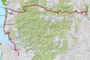
(Map by Oregon State Parks & Rec)
A bill to begin planning the Salmonberry Corridor — an 86-mile rails-to-trail project that would link Washington County’s Banks-Vernonia corridor to the Pacific Ocean — seems to be coasting through the state Senate, The Oregonian reports.
It’s backed by one of the body’s most influential members, centrist Democrat Betsy Johnson of Scappoose, who happens to be an occasional hiker and horse lover and says the path “could be a national, if not an international, draw” of tourism through her district.
As we’ve written over the last few months, some nature advocates see the path as a way to link both metro area and coast to each other and to some of the most beautiful country in the Coast Range. Some skeptics, however, warn that the rains that wiped out a railroad could easily wipe out a path, and others worry that a stream of people through the forest could lead to vandalism or eventually erode their right to hunt there.
But legislators seem to think the proposal is worth spending staff time on, even though there’s no plan to find the money yet.
Here’s the news from Oregonian state government reporter Harry Esteve:
Senate Bill 1516, which gives the state Parks and Recreation Department and the State Forester direction to move forward on planning the trail, is up for a key committee vote Thursday. It already passed one committee unanimously and is now before a budget committee, which Johnson anticipates will move it to the Senate floor.
“This isn’t something where we’re coming back and begging for tons of money,” she says.
The big money part may come later. What the bill does is direct the two agencies to work with other “stakeholders” to identify options for developing each segment of the trail and estimate the cost.
Once a detailed plan is in hand, Johnson says, the state can start decide whether and how to make it real.
A total cost estimate has not yet been determined but it would likely run in the millions. Supporters say money would be raised through grants and private donations.
The bill’s next hearing is today at 1 pm before the Natural Resources subcommittee of the Senate’s Committee on Ways and Means.
Correction 12:40 pm: An earlier version of this post and headline said a trail would be “paved.” This isn’t the only possibility. Here’s the relevant passage from the feasibility study (PDF): “Asphalt will be preferred for a bicycle trail and also good for ADA access, but a mountain bike trail similar to the Gales Creek trail could also be built. When the Banks-Vernonia Trail was first built, it was gravel, with predominant use by horse and mountain bike users. When it was paved with asphalt, user numbers increased dramatically, with associated user conflicts.”


Thanks for reading.
BikePortland has served this community with independent community journalism since 2005. We rely on subscriptions from readers like you to survive. Your financial support is vital in keeping this valuable resource alive and well.
Please subscribe today to strengthen and expand our work.
Exciting stuff! I can’t wait until we look back and say, “Remember when we weren’t totally sure this was going to be built?” as we’re riding our way to the coast.
NOOOOOOOOOOOOOOOOO! Please don’t pave it! Just restore and maintain it — as an unpaved path, like most of our other remote long-distance rail-trails. Just like the lower Deschutes rail-trail, the OC&E Woods Line, and most of the Klickitat and Crown Zellerbach trails.
If we want a paved path to the coast, how about the rail line to Astoria? My understanding is that is also under consideration for rail-trail conversion.
Disagree, but every is entitled to an opinion
i’m w/ granpa. +1000 for paving!
Agree 100%…more fun to ride…plus way, way less money
GlowBoy, thanks. I just realized this was my error. Pavement seems to be on the table but not a done deal. Here’s the relevant passage from the feasibility study (PDF): “Asphalt will be preferred for a bicycle trail and also good for ADA access, but a mountain bike trail similar to the Gales Creek trail could also be built.”
Sorry have no interest in offroad or gravel. please pave it.
or at least be a good grade path for hiking/biking that is not gravel/MTB.
Just went to DC to do advocacy work for the Pacific Crest Trail Association. I sat in on a presentation, which highlighted the economic benefits of trails, and how they can bring in much needed money to rural areas. It puzzles me why land owners in these rural area would not put their full support behind this trail.
Nothing new here, Christopher. EVERY time a new rail-trail is proposed ANYWHERE, local property owners oppose it, citing concerns about vandalism, garbage, campfires, etc.
And once the trail is built, everyone is thrilled. Ever after, any property for sale anywhere near the trail proclaims how close it is to this wonderful trail.
I’ve been around long enough to have seen this phenomenon over and over and over and over again.
Maybe they don’t want hordes of people in their old stomping grounds. I’ve spent a ton of time out there in the Salmonberry area, its beautiful, only those who really want to get out and get after it show up. We’ll go for three or four days and see one or two other people, unlike the Banks Vernonia Trail, which is paved and that’s fine if you like that. Problem is if they apply that to this trail in question along will come more rules, permits and permission slips. There will be no hunting anywhere near the trail any longer, no camping unless in designated places etc etc. It will be like Timothy lake out there. Sound like fun?
Last item, expense. I read a few of the comments about how this wont be expensive. Go hike it as is right now and think about the damages you see. I Cant imaging maintaining the crumbling tunnels, those will eventually need to be closed up and avoided or avoided all together. There will be many many bridges to construct and repair as well.
Lets leave this one little space in the woods alone, let it grow back, as it is now, its ok not to pave somethings.
Oh, god. Please build this so I have yet another reason to vacation out there and/or move back. I love NYC and there’s lots of rail trail action a short ride or train ride away near here, but riding to the Oregon coast on a rail trail? Le big sigh of yes.
I have ridden the C&O trail through Maryland into DC; a well maintained unpaved trail is thoroughly usable even with a road bike. Pavement isn’t necessary unless it helps slide and erosion resistance. My personal favorite would be graded gravel.
Dave: I’ve ridden the C&O path in Maryland as well as the Great Allegany Passage (GAP) and paved and unpaved trails in Minnesota, Wisconsin, and Michigan. I disagree with your assertion that an “unpaved trail is thoroughly usable even with a road bike…” Yes, my wife and I did accomplish it with a road bike, but we found the experience MUCH more enjoyable with a paved surface. We found the C&O trail through Maryland was the least well-maintained facility we encountered three summers ago.
I’d love to ride a traffic free path to the coast but why not just put a bike line on Highway 18?
* There’s no right-of-way to be purchased.
* The route is the least mountainous.
* The highway connects through Newburg, McMinville, Sharidan and Grand Ronde so there are plenty of services already in place.
* It’s about 100 miles between Portland in Lincoln City so the route isn’t too long.
* Only a slight widening of the road and some paint is required.
* The path could be made safer by adding bumps between the bike lane and car lane.
Most rideable routes to the coast are already pretty smooth sailing on a bike (47/202 to Astoria for example, or Nestucca River Rd), but this would be such a different experience, one that would draw a whole different set of users beyond the “strong and fearless” world.
Yes, but doesn’t 47/202 and Nestucca River Rd have no shoulder? Wouldn’t you want to take 30 to Astoria and 18 to Lincoln City where there’s a fairly wide shoulder most of the way?
Yes, there is no shoulder. But there is barely any traffic, either, vs 30 or 18 which have moderate to heavy traffic.
Exactly. Believe me, the portion of the ride on 30 (wide shoulder, high traffic) pales in comparison to the portions on 47/202 (no shoulder, low traffic). It is the amount of traffic, not the shoulder width, which makes it a great experience. And hence this Salmonberry trail would be totally awesome.
Oh Dirty 30. No I would not recommend riding that all the way to Astoria. 47/202 may lack a shoulder in spots, but it also lacks significant traffic. It’s quiet, pretty, and a great route.
By now you should know that BikePortland’s got this weird dichotomy of preferred modes. If it can’t be a landscaped neighborhood greenway or climate-controlled elevated cycle track, then it better be a shoulderless highway!
I don’t really get it, either. I guess it’s the all-powerful flagger lobby making sure that some of the best two-lane highway routes have to shunt down to a single lane for construction instead of reconfiguring the lanes.
“slight widening of road” would be used by go-fast boys and truckers cutting corners. It would increase speeds and not increase safety. A separated route would be golden and a separated route isolated from the noise, stink and thundering dynamic of passing vehicles would be the spec-f__k’n-tacular.
That’s why I mentioned adding bumps.
dbrunker, you just described most of the Reach the Beach route, except that at Grande Ronde it splits off hwy 18 and goes onto Little Nestucca River Road, which is a lovely and gentle way to get to the coast.
But it has nothing in common with a trail.
The money/budget to build…and maintain in years to come…this city to coast path, is probably one of the most important issues to consider. If this path’s width would be around half of, or near the same width of a two lane road, looking at the costs involved in building and maintaining them could be a way to a get a rough idea of the same for this path. 86 miles is a lot of concrete or asphalt.
Just a dirt path would no doubt be less time and money to build and maintain, less intrusive and toxic to the environment. A dirt path though, would have limitations. Maybe that’s a good thing, or maybe not. For people that like, or can ride in the dirt, it would probably be good to have just a dirt path.
On the other hand, there may be many people whose support a path like this may need in years to come, that couldn’t use a dirt surface to ride. That could have a bearing on what surface this path would have, or whether it even gets built at all.
I like riding theVan Duzer corridor too–why not think big and go for both?
Let the casino tribe have another demographic visiting other than alcoholic white trash gamblers.
Sounds OK by me!
awesome
After this, we need another one from Tillamook directly returning to Portland. That would make a nice loop for anywhere from a weekend to a full week, depending on stops, etc.
We will NEVER have warm feelings for that casino operation. We stopped there on a tour a number of years ago, returning from the coast. We inquired at security as to where to park our bikes safely while eating dinner. The response was that there was no place available, that bikes were not permitted on the premises and that we would have to leave immediately. When we found a place to eat a few miles further east, their comment was “I can’t believe that the casino actually turned down money!”.
If you have ever travelled to Idaho for the purpose of riding the Trail of the Couer d’Alenes you can see the parallel that this proposal presents for NW Oregon. Highly recommended !!!
How many people are going to ride a trail this long end to end?
Myself, for one, so you can put me down.
And I’m sure many of the folks who come in to Portland to start their Pacific Coast tours would, too.
As a long distance skateboarder I vote to pave it! I would love to ride that trail to the coast.
I hope this project doesn’t displace private land for eminent domain issues, that would be wrong, but it’s a great idea.