
(Photos by Barbara Stedman)
The Portland Bureau of Transportation has been busy in southwest Portland lately. We recently shared their plans for a new protected bike path on the Terwilliger “teardrop” and BikePortland reader Barbara Stedman has been keeping us in the loop on a host of other, bike-friendly changes going on in the area.
Stedman is a daily bike rider who lives in Hillsdale with her daughter Helena and husband Kenneth (we profiled their morning commute last year).
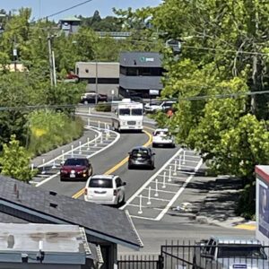
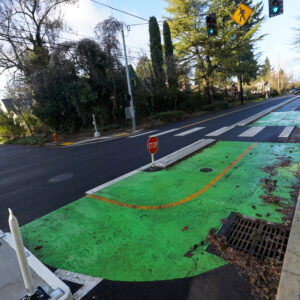
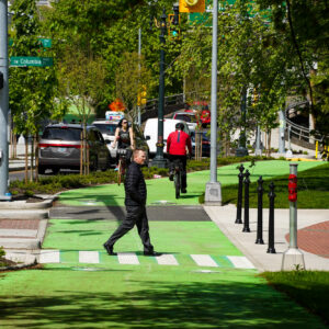
Stedman has recently noticed a new sidewalk and bike lane on SW Sunset near the Hillsdale Library and she’s eagerly watching progress on PBOT’s project on SW Multnomah (between 22nd and 40th) which will include a new sidewalk and cycle track. With a six-year old who rides her own bike in traffic, Stedman is also excited for the soon-to-be built SW Ilinois-Vermont neighborhood greenway project.
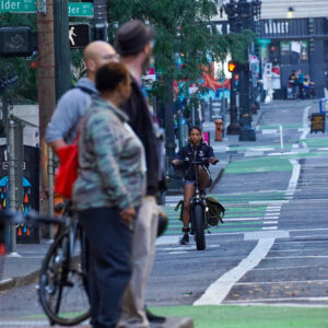
Today we’re going to share Stedman’s photos and thoughts on the new buffered bike lanes on Beaverton-Hillsdale Highway (BHH) that PBOT installed about a month ago


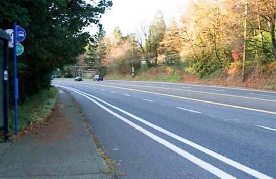
The newly buffered lanes go about 2 miles from SW Dosch to about 45th. To get room for this extra, bike-only space, PBOT simply narrowed the existing standard vehicle lanes (there are four total, plus a center turn lane) by one foot (from 12 to 11 feet wide). Stedman reports that the newly widened bike lanes are also expected to be used by people walking, since sidewalks are absent along much of this corridor.
These changes to BHH come out of PBOT’s High Crash Corridor program. With little in the way of traffic calming, BHH is notorious for its high speed driving. The widened bike lanes are just one in a host of measures PBOT will take to tame BHH in the coming months and years.
Stedman is happy to see them; but she calls it just “a small step” in the right direction. “They offer a little bit more protection on a fast paced highway, but nothing that would encourage the “interested, but concerned” or children. I wouldn’t voluntarily ride longer stretches on it.” To really get people out on bikes, Stedman would have liked to have seen a full-fledged cycle track.
It’s interesting to see how PBOT addresses safety problems on BHH. It has a similar profile to nearby Barbur Blvd, but that notoriously dangerous road is managed by the Oregon Department of Transportation.


Thanks for reading.
BikePortland has served this community with independent community journalism since 2005. We rely on subscriptions from readers like you to survive. Your financial support is vital in keeping this valuable resource alive and well.
Please subscribe today to strengthen and expand our work.
Oh man. I mean, it’s kind of nice that they built them. But seriously, this is kind of a bad joke.
No actual fixes to the road, no clear physical buffering, just paint. Better than nothing I guess, but damn… people are still going to die for lack of doing it right.
I love how it’s always, cars cars cars, oh yeah, people can walk in it too, “see now we’ve thought of everybody”…
:-/
I’m gonna shutup now cuz’ I got nothing else positive to say about that paint on the road. o_O
As someone who commutes on this route fairly regularly, I have to say the wider lane is a huge improvement. I have a slightly larger buffer, but more importantly I can ride side by side with a fellow commuter if I wish, or scoot over if I’m feeling squished.
I for one don’t want physical buffering and I am distinctly less safe when I am separated from traffic. There is no better example of this than the Eastbound Hawthorne bridge. I don’t want to be separated from traffic, I want to be treated like traffic.
If separated tracks get more people riding, then I support that. But I think its one track minded to call this improvement a bad joke because it doesn’t conform to what you perceive as safe and right. Not to Heine all over the place, but I think physical barriers are less safe, and I don’t want them here.
I think the joke is calling this “buffered.” It clearly IS NOT BUFFERED.
What is the actual width of the bike lane and the actual width of the “buffer”? It is difficult to tell from the pictures.
How about law enforcement? Speeding tickets? Too unpopular?
How about bright strobing white bike lights?
We know drivers see them well enough to whine, complain and write misguided op-eds.
As a biker I am frequently blinded by these lights. They do not help me see a biker, and they are distracting to seeing other obstacles. I really wish they’d die in a fire.
its truly amazing to me how i never have this problem. in fact, when i see someone with a bright light i tend to shout out “nice light”!
If you only ride along well lit streets it wouldn’t be too amazing you hold this opinion, and in that environment I couldn’t agree with you more. However, your compliment might be taken for sarcasm along the Springwater during the pitch black hours.
Strangely enough, this section of BHH (which I both bike and drive) doesn’t get too much speeding. You could reasonably argue that the speed limit is set too high (it starts at 30 on the East End and is 40 for most of the section) but I rarely encounter people going over the limit…at least in the 40 section.
I personally think that Multnomah and Vermont (which also have bike lanes…not this wide though) are bigger problems for speeding in that area. I still prefer them to BHH because the overall traffic volume is less but I feel less safe when being passed because the roads are narrower and less open/visible than BHH.
I’ve seen a transit bus going over 50 mph on BHH in the 35th block back in around 2012 / 2013.
This is a good start at addressing another poorly designed out of date arterial…
…does anyone know if PBoT will be adding any reflectorized RPMs in the buffer to help visually segregate the lanes?…this is very helpful for higher speed arterials during these dark and wet months.
I, too would be interested in the widths here. It seems that the bike lane hasn’t actually been widened, it has been “offset” further away from the space that cars are “supposed to” occupy. I have a new-ish bike lane in my neighborhood that looks like it was painted at a nice 6-ft width, but then a buffer line was added inside that width to create a 4- or 5-ft bike lane with a 1- to 2-ft. buffer. Sort of defeats the purpose in my view.
The few times I’ve driven BHH lately, I’ve seen plenty of other hazards that virtually eliminate the WB bike lane just after the Capitol split coming down from Hillsdale: I saw gravel and great piles of leaves narrowing the bike lane down to just the buffer in places. Maybe those spots have been cleaned up, but expecting pedestrians to use this space as well creates a de-facto painted MUP (even though pedestrian use of bike lanes is technically illegal), which is more dangerous than nothing at all. Half-assed “protection” creating an illusion of safety does no one any favors–except drivers of cars.
The inner line in the picture is the original bike lane stripe. They simply added another line without removing the original striping. Overall I’d say its roughly a foot wider.
When do pedestrians need to yield to cyclists on the BHH highway in areas that clearly lack sidewalks? Such as where Fanno Creek goes under the highway just west of 30th Ave?
Why is the bike lane so narrow and the gutter/debris-buffer so wide? Are there any photos from the inaugural up-hill policymakers ride?
Not sure, but BES and PBOT plan to make stormwater improvements in 2015 on the BHH from Sunset Blvd to 65th Ave when it becomes a slower, 35 mph zone in Raleigh Hills.
I rode this not long after they finished it and feel like it is much better than before. Partly that’s just the fresh paint effect though: once the paint wears down the visual separation won’t be so stark.
The only downside (maybe an upside?) is now it is even more obvious where the MultCo/WashCo border is (the buffer ends, and not long after that the bike lane vanishes).
The bike lane in Raleigh Hills starts (eastbound) right in front of the new shoe store which is right where the Oleson Road Realignment project would put the new Oleson road.
And people on bikes are supposed to share the “bike” lane with people on foot?
“…Stedman is happy to see them; but she calls it just “a small step” in the right direction. “They offer a little bit more protection on a fast paced highway, but nothing that would encourage the “interested, but concerned” or children. I wouldn’t voluntarily ride longer stretches on it.” To really get people out on bikes, Stedman would have liked to have seen a full-fledged cycle track. …” bikeportland
Haven’t ridden this section of the road since the buffer installation, but expect what I find will agree with Stedman’s characterization of the change. It would take very serious commitment to make it happen, but a full-fledged cycle track, physically distanced from B-H highway some 10′-15′ could be a great idea, extending all the way from Hillsdale to Beaverton.
“…It’s interesting to see how PBOT addresses safety problems on BHH. It has a similar profile to nearby Barbur Blvd, but that notoriously dangerous road is managed by the Oregon Department of Transportation.” maus/bikeportland
Okay, it’s off topic, but here’s something for you to think about, if you haven’t already: If PBOT managed Barbur, how would the city dept address safety on Barbur, in a way that corresponds with the changes made to B-H highway, which has not had its number of lanes reduced via a road diet? Possibly, existing main lanes and non-continuous bike lanes on Barbur, could be realigned to allow installation of a pavement line designated buffer area. That still leaves the bridge areas of the road, where the road narrows; involving a hugely expensive and/or, dramatic alteration of the road to achieve.
Hate to say it but Beaverton has the best bike lanes in the metro region.
except this is in Portland……..
Where are the bike lanes on the southern part of deadly SW Laurelwood Ave? The Fanno Creek Trails’ history and support all started in Garden Home (not Beaverton) and Washington County were the ones behind the Oleson Road overhaul and the new 2015 Fanno Creek bridge on Oleson Road. The 2014 improvements to 92nd Ave near the Fanno Creek Trail are from Washington County (Garden Home).
the route now “feels” much safer with traffic only drifting over the buffer line, and not the bike lane, thus keeping me alive to write this post.
The bike lanes still get too close to the dirt-packed storm grates.
Buffered? Bah. My instincts tell me that no painted buffer under four feet is going to add any measure of protection from drivers who drift. Put in some candlesticks (with teeth) and drivers might learn to respect the “buffer”.
> Put in some candlesticks (with teeth) and drivers might learn to respect the “buffer”.
Rumble strips could help. I’d love to see them at the edge of the standard travel lane just before or on the stripe (also, they’d need to be narrow and thin with gaps so they don’t suck for bicycles). This ODOT data sheet notes that they’re one of the “nine safety countermeasures” (sidenote: aren’t they a “danger countermeasure”?) and could reduce crashes by about 16%.
http://www.oregon.gov/ODOT/HWY/TRAFFIC-ROADWAY/docs/pdf/RumbleStripsFactSheet.pdf
Drivers tend to drift into bike lanes when the lanes are on the inside of curves. I think some rumble treatment (strips, raised reflectors, etc) might be helpful there.
A few months of aggressive enforcement of the “Failure to maintain a lane” statute during the day time instead of only as a pretense/fallback for DUII stops. This would go a long way toward fixing that particular bad driving habit. It’s not just at curves, though this is where it’s most pronounced.
PBOT needs to encourage Washington County and ODOT (who have jurisdiction over Scholls Ferry and Oleson roads) to provide good connections with the bike lanes on these streets. Currently, the Raleigh Hills area is a disaster, discouraging bicycling on BH Hwy.
Lacking, in terms of encouragement to Washington County to make improvements to bike infrastructure it’s responsible for, is encouragement from the citizen level. The hair raising bike infrastructure through Raleigh Hills and plenty other areas, may likely be due in no small part, to property ownership of land adjoining the roadway/bike lanes.
Update but the CPO3 meeting for Garden Home, Raleigh Hills, and West Slope plan to show what it could look like if all three neighborhoods formed an official city to fight annexation from Beaverton forever and finally fix crash corner by Parr Lumber. Washington County is currently working on a $7.3 dollar Fanno Creek bridge and safety improvements to the shoulder near SW Raleighwood Way to SW Hamilton St.
I would like to see them install rumble bumps as a standard practice on higher speed roads like this. Other than collisions at intersections, my biggest fear is a distracted driver drifting to the right and nailing me at 50mph. ODOT just widened a section of outer NE Sandy and applied this treatment.
I rode this stretch of BHH both directions several times per week up through the time change. The safety improvement was awesome but its still too sketch for me to ride it in the dark.
The bike lane is ~5ft and the buffer adds another 2ft. The 2ft buffer was taken out of each of the travel lanes (now down to 11ft each). It’s easily the best safety improvement in the metro area per $ spent in my opinion.
The buffered bikelanes are the most PBOT could afford I guess. There are almost no sidewalks, yet BHH is lined with apartment buildings. People who want to take the bus have to walk along the road (in the bikelane) or jot across 4 lanes of traffic risking their lives. Marked crossings are far and few between as well. So in an ideal world PBOT would install sidewalks and a cycletrack, but I guess we get what we pay for.
Agree. BHH is disgraceful to all except car drivers. While the buffered lanes help ease the anxiety a bit, the speed differential between bikes and cars is enormous; like Barbur, its design promotes high auto speeds. I ride this every day and see car accidents roughly every other week, especially as you approach the 5-corners intersection, which is a total clusterfk. This road is in desperate need of speed reduction, more flashing-light crosswalks, more sidewalks, and more red lights or timed green-lights that promote traveling 30mph, not 50. And god-forbid you have to make a left-turn on your bike during evening rush-hour in the rain. So unnerving….
Washington County has 50 % of the money needed to fund design for the Oleson Road Realignment by Parr Lumber. Citizens need to urge state and federal leaders to fix that area, clean nearby Fanno Creek, and bring in more small businesses.
Well, that’s it. People live in housing along the road…some catch the bus at stops along the road, some residents may be using the bike lane. Are they actively making requests to the city that something more substantial, like a generously wide MUP or cycle track be built along B-H highway? If a cycle track was seen by developers, the city, and investors, to be good for growth and development…interest would be directed towards considering planning that type infrastructure.
By the way…if you remember, please remind us what the posted speed limit for B-H highway is, say between Shattuck, and the Bertha Beaverton turn-off.
The posted speed limit is mostly 40 in the Portland section (35 in Wash County) and is reduced to 30 between 26th (school) and Bertha Blvd. of course most cars go faster, probably around 50.
Yes. When I drive I have to remind myself constantly that the limit is 30mph. The road is designed to happily accomodate 50mph+.
Yep, I actually stick to the 30mph speed limit when I drive the stretch between Hillsdale and 30th. Everyone passes me. EVERYONE.
The scary thing is that it is even a school zone! Not to mention a blind curve heading east toward Hillsdale. I haven even witnessed cars zooming right through the red light of the pedestrian crosswalk on 26th that Hillsdale and Multnomah village kids have to use to get to the middle school. At least the police is enforcing here occasionally.
5 lanes, not 4.
> Agree. BHH is disgraceful to all except car drivers. While the buffered lanes help ease the anxiety a bit, the speed differential between bikes and cars is enormous;
It constantly amazes me that Portland is lauded for having a non auto focus, yet we have a road network that not only allows motor vehicles to go everywhere, but sometimes even has multiple lanes in each direction for autos in the same places where we have zero lanes for people walking or biking.
This kind of sums up most of the SW (especially the area surrounding BHH). One of the main reasons we moved to east side after only one year of living there.
Developers and politicians got hungry for money, letting developers off the hook to pay for sidewalks and crosswalks.
Sounds like those who are criticizing the change, or don’t think this qualifies as a buffered lane, are people who DON’T have to regularly ride between Beaverton and Portland. Listen, those of us who do are forced to choose between some really bad options. This is far from ideal, but it’s a big improvement for us. Personally I still won’t ride BHH in the dark (I go over Sylvan in the winter, even though the route is longer, steeper and slower). But now I will ride the much-faster BHH route in daylight, and it’s not an exaggeration to say that this has amounted to a pretty substantial improvement in my life.
For the record, this project was done around the end of August (which is why it’s already improved my life, even though I don’t ride it in the dark). Not “about a month ago” as BP is reporting here. It just took that long for BP to find out about it. I have mentioned it in the comments section a number of times, including pointing out its omission from a recent post about new bike lane activity around town, but this area’s pretty far off BP’s radar.
To those who are outraged that PBOT “expects” people to walk in these bike lanes: they already did! I find myself sharing this bike lane with at least one pedestrian almost every time I ride it. Thanks to this extra buffer, at least I’m no longer forced into the car lane to go around pedestrians now.
Yes, this bike lane still has problems. In their zeal to maintain an 11-foot car-lane width, PBOT allows the width of the buffer to fluctuate. The places where it gets narrowest also happen to be on the inside of a couple of curves that IMO were already the worst spots for cars to encroach on the bike lane.
The bigger problems with this buffered bike lane, of course, have to do with the fact that it doesn’t cross the Washington County line. Just a couple blocks before you enter MultCo, on the eastbound side you’re forced to ride in the NARROWEST bike lane I have ever seen (right in front of Key Bank, for those who want to check it out). And the Five Corners intersection is indeed a complete clusterfk as Nick has pointed out, and unavoidable as there is no possible crossing of Oleson/Scholls Ferry for nearly two miles in either direction. And then, west of there the bike lane disappears completely (well, actually, in true WashCo style it comes and goes a couple of times) even though the PAVEMENT IS WIDE ENOUGH for a continuous bike lane while maintaining 12 foot travel lanes. Way to go, ODOT!
Given the state of BHH once you cross into Washington County, these newly buffered lanes are paradise.
> Just a couple blocks before you enter MultCo, on the eastbound side you’re forced to ride in the NARROWEST bike lane I have ever seen (right in front of Key Bank, for those who want to check it out).
Has anyone measured that? I thought it was very odd that WashCo allowed that development to happen in the way it did (which seemed to narrow the bike lane) but I don’t usually ride with a measuring tape or good camera so I haven’t brought this up with staff.
Shelley Oylear is the very wonderful bike/ped coordinator for WashCo and is often helpful — I’d suggest contacting her to ask about the narrow bike lane and the idea of adding bike lanes on BHH further west:
Haven’t bothered to measure it, but I’ve been tempted to stop and do it.
It really astounded me that when they redid the Key Bank branch, they completely tore out the old sidewalk (blocking the bike lane for weeks on end, during the time of year when I most want to ride BHH) and rebuilt it EXACTLY as wide as before, still pinching the bike lane. One of the most myopic things I’ve ever seen done on a state highway.
I was just going to comment on that. I don’t think it was a redo though, as there wasn’t a bank there before (just an older retail shop). That sidewalk is only 2.5 years old. I stuck it to them though! Accidently ran on it when the cement was still wet, and they had to go back over and smooth out my footprints the next day.
> Haven’t bothered to measure it, but I’ve been tempted to stop and do it.
Please do. I’d be curious to know, and these things need to get documented.
The other crazy thing that happened out that way was when the mall at Cedar Hills was redeveloped they rebuilt half the street but didn’t put in a bike lane.
Done. Brought a ruler home from work with me and took this route so I could check it out.
At its tightest point in front of Key Bank, the bike lane measures 20.5″ from the curb to the inside of the white line, and 23″ wide from the curb to the center of the white line. I’m pretty sure my handlebars are wider than that.
> Done. Brought a ruler home from work with me and took this route so I could check it out.
Thanks!
exactly. I get the feeling that 90% of the people on this site have never ridden this stretch.
Washington County is in the process of designing and constructing a major multi-stage project at “5 Corners” that will replace the bridge over Fanno Creek on Oleson Road and provide safety and traffic capacity improvements to the entire intersection.
My Mind = Blown.
They’re planning on redoing that intersection? Now THAT would be nice.
Would like to know more about if this redesign includes connections to the bicycle facilities on the Portland side. I live in Raleigh Hills and would consider myself a “confident” cyclist, but still the prospect of biking through 5 Corners scares me!
check “Oleson Road Realignment” and Malfunction Junction
Getting to “5 Corners” is trickier than getting through it, IMO. The only real trick is if you have to turn left, say, from WB BHH onto SB Scholls Ferry. For that, I’ve taken to cutting through the Wells Fargo parking lot (entering from BHH right as the striped shoulder disappears, and exiting directly across from the West Hills Office Plaza) and taking a left onto Scholls Ferry, then staying in the through (not the rightmost) lane to continue up Scholls Ferry.
Heading into town (EB) if you come down BHH from Raleigh Hills Fred Meyer, congratulations, that’s the hard part. Traffic is usually stopped at the lights at Scholls Ferry and you can just move into the lane to go through the intersection. If you’re coming down Scholls Ferry from the SW, just take the lane at the bottom of the hill and turn right onto BHH—don’t give up the full lane until you cross Oleson; traffic will be moving slow enough that no one should care that you are in the lane.
“Traffic is usually stopped at the lights at Scholls Ferry and you can just move into the lane to go through the intersection.”
Yeah, as long as you don’t mind waiting a few extra cycles to get through the light. Many afternoons that intersection backs up most of the way to Fred Meyer. If I’m coming that way I usually carefully ride the risk-littered sidewalk.
I usually come at it from WB Scholls Ferry, as you suggest, rather than from BHH.
Well, to avoid confusion, I didn’t mention my dirty little secret of carefully passing the stopped cars on their right where there is room, then merging between cars as they start up on the green light. But that was a long time ago, I now usually approach from Scholls Ferry as well.
People need to demand that representative Tobias Read and Senator Mark Hass work to fix crash corner. It is 1/4 mile from Multnomah county and in TriMet’s top 10 list of intersections that need a overhaul.
Alexandra and Glowboy, it’s a multi-stage design effort, meaning each stage is like it’s own project with potentially separate design firms and contractor. Each project could take 1-2 years **once funding is secured**. I don’t expect this intersection to be considered fully bikeable by the majority of cyclists until at least 2025.
and Beaverton and PBOT ought to help contribute money towards the Oleson Road Realignment project ($40 million project) considering they have annexed acres and acres of nearby land in Raleigh Hills, West Slope, and Garden Home since the 1960s.
This is awesome BTW but we need laws that protect ppl in the bike lane some drivers like to swerve into the lane or shoot down it to get off the road fast 🙁 careful if you hug the white line while ride just because its buffered your still in danger of whats behind you. I ride Fanno from start to finish and glad they are working on some safer infra areas that end into a busy street with speeding cars… HALL RD
Cedar Hills is crazy I rode that for 3 years its madness be safe if you ride it, all I have to say.. * I take the lane and keep up with traffic no bike lane lotta place for cars to right hook some get mad but I’m just trying to get out of that spot alive
Buffered bike lanes are great… in the right context. Streets with moderate levels of traffic and speeds in the 25mp-ish range? Wonderful. Streets with high traffic and high speeds situated in the middle of a nation with no real legal or cultural expectations to drive safely? A joke.
yes drive safely is really not happening these days!
It’s remarkable seeing cyclists carefully riding between the two narrow lines, closer to traffic than ever before. Seems like some hashes or other marking between the double whites would have been prudent.
Can’t say I’ve seen that. All the cyclists I’ve seen on BHH (which I ride almost daily) were in the actual bike lane.
When I ride BHH, some cyclists pass me right in the new buffer lane.
Also, too bad some construction project has BLOCKED the westbound bike lane – and buffer – for about 50 yards, just prior to Bertha Blvd for the last couple of weeks. There are signs that say “BIKE LANE CLOSED” and “NO PEDESTRIAN” access, but no f*cking detour posted as if we’re just supposed to teleport across their little project.
There’s almost room for a skinny bike lane next to the jersey barriers they’ve put up, or they could temporarily restripe since there’s way more than enough pavement there. But as it is we’re forced out into busy highway traffic.
Platinum my ass.
That is a sewer BES project to help with nearby Fanno Creek. check SW Trails
Turns out, maybe, that while buffered bike lanes sell the idea to cyclists, the real safety value lies in narrower vehicle lanes. Some great ideas based on solid research and engineering in the article above.
Here’s the link: http://www.citylab.com/design/2014/10/why-12-foot-traffic-lanes-are-disastrous-for-safety-and-must-be-replaced-now/381117/
Great link. And applied to the road in question, it would be awesome of BHH/Capitol Blvd had 10 foot lanes at least through central Hillsdale. Many drivers really fly through that busy pedestrian district, at well above the posted 25 mph.