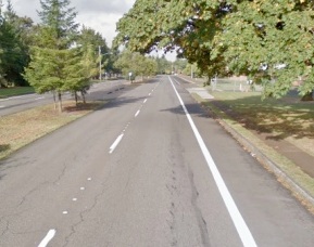
The City of Vancouver has just announced that the entire stretch of MacArthur Blvd from East Mill Plain to South Lieser Road will have a dedicated bike lane.
Thanks to the diligence and perseverance of activists and local bike riders, the city reversed an earlier decision to remove bike lanes and replace them with sharrows along a popular bike commuter and recreational route, and is now planning a ‘right-sized’ road with one lane of traffic and a buffered bike lane in each direction. “The reconfigured MacArthur will continue to meet the needs of the current traffic volumes,” reads the City’s project website, “while allowing for full bike lanes in each direction.”
MacArthur Blvd., the only east-west bike corridor in the city, has long been considered overly developed for auto traffic, with two lanes in each direction through a residential neighborhood with several schools along the route. A resurfacing and restriping project opened up possibilities to reconfigure the road. In April, the city conducted traffic volume and speed studies and found, what cyclists and others already knew, that the number of cars didn’t warrant four lanes, and that the average speed was too high to provide safety for cyclists in a sharrowed lane.
“We’re a long way from the transportation designs of Europe or even Portland, but this is a very positive step.”
— Jan Verrinder, who lives and rides along the MacArthur corridor
Local citizen activists are celebrating the victory. “This totally changes the reputation of Vancouver,” said Eric Giacchino, president of Bike Clark County. “It puts the city council in the forefront of promoting active transportation in the city and making us more bike friendly.”
Jan Verrinder, a resident along the corridor, “Our city’s decision is a huge step in the right direction. Our mayor came out on a Tour de Mac with us and was joined by more than 50 other cyclists. Our city council listened and our city engineers executed a new traffic volume and speed study giving them the numbers that turned the tide. Most of all, to me however, it was a sign that we can work together for all road users. We’re a long way from the transportation designs of Europe or even Portland, but this is a very positive step.”

The city’s public works department will be presenting this proposal to the city council Monday. Activists are urging everyone who cares about traffic safety to attend the meeting to thank the city for choosing what is a controversial plan in that neighborhood and to show support more forward-thinking transportation planning in the city. Activists will be gathering at 6:30 pm outside the council chambers: 415 West 6th St., Vancouver, 2nd Floor.
Learn more about this project, and their rationale for the road diet and bike lanes, on the City of Vancouver’s website.


Thanks for reading.
BikePortland has served this community with independent community journalism since 2005. We rely on subscriptions from readers like you to survive. Your financial support is vital in keeping this valuable resource alive and well.
Please subscribe today to strengthen and expand our work.
This is really good news for Vancouver cyclists and commuters. The city staff did their homework, came up with a sound report referencing neighborhood plans, traffic speeds and volumes and made the right decision. It’s a great bicycle corridor and this decision will make it safer for the community & the two schools along the route. Nice work!
Yes! Advocacy, planning, and engineering done right. Finally.
This is great news for Vancouver! I ride this road daily. This is left over from when housing was originally built for the ship yards during WWII. There is an enormous right of way, but it’s been dominated by this over sized road, with pitiful sidewalks that are only about 30 inches wide (or less) and in many places in poor condition. The current bike lanes are sub standard and just aweful in some stretches. The whole corridor as it is shouts that the City of Vancouver is working to make active transportation as unappealing as possible.
NOW we are going to have a really nice cycling corridor for almost 1 mile at least. I fully expect cyclists are going to have to share with other users, but this is good. Hopefully we will build community support for a good walking path and for improved crossings at cross streets.
I saw the heading and thought of you, Paul.
Happy day.
Woohoo! Any more names to thank? (especially ones which might show up on a ballot)
Yes! They need to hear from us, to know that this decision is supported. The first three are staff; the rest are city council members. Please write and thank them.
Here’s the list:
eric.holmes@cityofvancouver.us
brian.carlson@cityofvancouver.us
ryan.miles@cityofvancouver.us;
tim.leavitt@cityofvancouver.us
jack.burkman@cityofvancouver.us
larry.smith@cityofvancouver.us
bart.hansen@cityofvancouver.us
jeanne.stewart@cityofvancouver.us
jeanne.harris@cityofvancouver.us
Great work for all those who continued to push the issue and show up at the meetings. It would have been easy to give up and not challenge the all powerful and knowing engineers. Existing and future cyclists thank you. It all happens one street at a time.
This is good news. I ride this road every now and then, and was completely scratching my head at what they were think? There is so much road here, barely used by cars and they wanted to remove the bike lanes? I just saw no upside to this logic. Glad to see they came to their senses.
@ Alan 1.0: There was a lot of positive engagement and listening on the part of City elected officials and staff. In particular: Mayor Leavitt participated in a bike tour; Councilmen Jack Burkman and Bart Hanson returned phone calls, talked with staff & Burkman even attended neighborhood workshops to hear citizen input; City Manager Eric Holmes asked great questions and seemed to appreciate the value of good multi-modal transportation. In the end, Operations director Brian Carlson and engineer Ryan Miles did the research and report writing that formed a solid basis for the decision.
what makes it a bike corridor? bike lanes? that seems to be the only thing bike-specific about the street… which puts it on par with E 18th St and E Evergreen Blvd, both of which have longer east-west bike lanes than MacArthur…
It’s on the top of the hill and linked with McGloughlin to the west and east on St. Helens, 11th and McGilvery makes a corridor than can be ridden from Grand to 192nd without going up a hill and most of that is fairly pleasant riding that cyclists who aren’t too comfortable with traffic find not too threatening. From Mill Plain to 164th you don’t even have a major intersection to navigate. Also, HP Campus, the Tech Center, and BowFlex, Nautilus, and many other large employers are located around the 164th street terminus of that corridor. Peach Health Southwest is adjacent to this corridor. Many people connect up the hill from Evergreen (which you mentioned). Further this corridor goes through a large swath of residential Vancouver.
18th has adequate bike lanes (and not more), and just isn’t pleasant. More importantly for many (or most) destinations it requires going back up the hill. Evergreen / River drive is pleasant but down at the bottom of the hill with very limited opportunities to get to destinations at the top of the hill. Many people to connect from MacArthur to Evergreen via Brandford.
I agree that it isn’t quite THE ONLY east west corridor, but it is superior to 18th / Burton / 28th in every way. Evergreen / River Drive isn’t bad but doesn’t access a single business west of grand. The next route to the north is Padden Parkway which is separate path but that’s a whole different territory out there.
Great comments Paul. The only exceptions I have are “McGloughlin” is spelled McLoughlin & Brandford is spelled Blandford. I attended McLoughlin Jr High School, aka Mac Hi in the late 1960’s & use Blandford Dr everytime I come to Vancouver to see my parents. Excellent write up otherwise.
Thanks. Yes, I even realized I put the “G” in there…. later. I type faster than I think. Blandford I am only just managing to remember the name of after riding it for years.
also, if you look at this corridor it goes by Martin Luther King Elementary, McGloughlin Middle School, Marshall Elementary, Leiser School (home school link and head start), St. Joseph Catholic School, Wy East Middle School, Riverview Elementary, and Mountain View High School. Vancouver’s newest High School opening next year is adjacent to Peace Health Southwest, which is on the plain with this route.
This corridor (Manix’s “the 3 M Route”) has long been “the” linch pin between east and west Vancouver for cyclists long before I joined the City to work on similar projects in 1999 and before there were bike lanes in the city. The existing 2008 striping was done as an “interium” change during some NTSA funded ADA Pedestrian corridor work until additional information could be collected and the current overlay work was initiated.
Awesome. I ride that stretch a lot, and for the most part, ride in the right ‘car’ lane instead of the ‘bike lane’ because so much of it is choppy and off camber.
Now if we can get them to resurface the Old Highway out to Camas (that’d be something).
how wide is the single travel lane going to be? and what will be the posted limit?
Not sure what it will be but the present speed limit is 35, average (both directions) is 37 and 85th percentile is 41 per: http://www.columbian.com/news/2013/jun/22/macarthur-bike-lanes-advised/
That article also give the time when the City Council will hear details of the new plan as 4 p.m. Monday, not 6:30 pm as mentioned above. Can someone confirm on those times?
Paul, agreed on E-W routes, and both 18th and 28th are shoulderless, fast and bike-hostile east of ~136th.
Amy, thanks for the names!
Regarding the time of the work session Monday: It’s at 4pm and is open to the public; however the public can’t comment during the session. The Citizen Forum begins a little after 6:30; that’s when we, cyclists, can speak and show our support for the right-sized road.
We are waiting for the 4PM (16:00 PST) workshop for details on the configuration, as you know the devil is in the details.
Our City Council Workshops and Council Meetings are simulcast (and saved for late web viewing) at this address, tune into to see more today:
http://old.cityofvancouver.us/cvtv/cvtvindex.asp?content=25582
Nice to see a sensible design win out, thanks to all who wrote to city council or otherwise supported the road diet. Looking forward to riding it after it’s been done.
Ted Buehler
excellent news!
It’s good to hear about, but MacArthur is already a good cycling street–the real need is to enlarge and upgrade the chintzy, weedy sidewalks.
Just heard that city council has been slammed with messages opposing the new plan. Please come to the council citizen forum at 6:30 to show support for the right-sized road – one traffic lane and a dedicated bike lane in each direction.
To clarify Madeliene’s comment above … the City Councilors mentioned getting some calls to complain about the MacArthur lane drop but the number of calls did not outweight the safety and liveability outcomes of this project…especially for a corridor with so many schools.
In my long experience with similar projects at the City, MacArthur has 4x the roadway capacity for its current volume trends (it has <1/2 the volume of past arterials given a diet) and any time the City updates its lane configuration on arterials it gets complaint calls but typically a much higher number…this facility update is for the most part a no brainer that serves all users. The Council members who have been with the City a long time mentioned last night that the doom and gloom threats by opponents of right sized streets do not come true over time in their experience.
…and thanks to the many residents, car drivers and cyclists who came out last night to speak in favour of this project.
PS. Most of our City’s pavement overlay projects are funded through a pot of money from tax on real estate transactions and general funds…versus being a majority from fuel taxes (state and county projects), so this is an additional reason to use these funds for vulnerable road user safety and active transportation connectivity.
Todd, understood on the city street funding (e.g. Josh Cohen’s “We All Pay for the Roads”) but do you have a source for this part?
“…majority from fuel taxes (state and county projects)…”
What I’ve read is that federal funding for roads is about 60% user fees (gas tax, truck fees, licensing, tolls, etc), and that the fraction coming from user fees goes down substantially for state highway funds, and even less for counties, so I’m kinda guessing that user fees account for less than half of those roads. If you have a good source for how state and county road funds are based I would like to add it to my collection.
Madeleine – thanks for the list of contacts! My thank-you to the city council is on its way.