some explaining to do.
(Photo © J. Maus/BikePortland)
It’s finally over. Seriously. I mean it this time.
After 17 months of meetings and open houses, the stakeholder advisory committee (SAC) for the N Williams Traffic Operations Safety Project finished their work yesterday with the adoption of plans that will transform Williams Ave. from Weidler to Killingsworth.
The majority of the design has already been agreed on; but unfinished business remained on one section — from Fargo to Fremont — that turned unexpectedly contentious at an open house last month.
The committee thought their work was done after they adopted a formal recommendation to PBOT at their March meeting; but when PBOT showed up to an open house on May 22nd with new plans, many SAC members were surprised at what was presented for the stretch between Fargo and Fremont — an area expected to grow busier with the addition of New Seasons Market and other developments in the works.
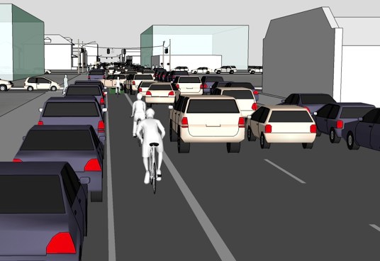
Instead of the one standard vehicle lane and one shared left-lane concept (that would utilize sharrows), PBOT unveiled a two standard vehicle lane cross-section with a six-foot, un-buffered bike lane that maintained on-street auto parking on the west side of the street.
Here’s a graphic of what PBOT was proposing (basically exactly what we have now except with the bike lane on the left)…
That design upset members of the SAC, not only because they felt it didn’t meet their standards for safety, but also because they felt PBOT failed to vet it with them prior to the open house.
“I feel like at that point, the process became less transparent,” said SAC member Michelle DePass at today’s meeting, “I felt out of the loop.” Susan Peithman, a staffer for the Bicycle Transportation Alliance (BTA) who sits on the committee, said, “I was surprised by the designs and thought we’d moved beyond the design phase.”
“Clearly some of you feel PBOT missed the mark. If that’s the case, I don’t want to be defensive about that, let’s just fix it. Let’s, with your input, get closer to what you’d like to see.”
— Rob Burchfield, City Traffic Engineer
For their part, PBOT says they were only doing what the SAC asked them to do in the Fargo to Fremont section, which was (according to the recommendation), “to develop a design that makes a safe and comfortable transition from the buffered bike lane to the shared left‐turn lane/bikeway.” PBOT also says they were working on the design right up until the open house and simply didn’t have time to share it beforehand.
Even so, City Traffic Engineer Rob Burchfield offered his apologies. “Clearly some of you feel PBOT missed the mark. If that’s the case, I don’t want to be defensive about that, let’s just fix it. Let’s, with your input, get closer to what you’d like to see.”
Tuesday’s meeting was an opportunity for PBOT to respond to the SAC’s concerns and to get their final support for a design. (It’s worth noting that SAC members weren’t the only ones peeved by what PBOT showed at the open house. At today’s meeting, we were given a packet with 18 public comments emailed to PBOT on May 22nd. All of the comments expressed disappointment and concerns about various aspects of the design.)
In a presentation to the SAC, Burchfield explained why PBOT feels it’s imperative to have two standard vehicle lanes for the three block stretch between Fargo and Fremont.
In short, Burchfield says PBOT’s traffic analysis shows two standard travel lanes are necessary in order to create adequate capacity for motor vehicles given the boom in development on the horizon. Burchfield shared that he and his staff have met privately with developers and representatives from New Seasons to better understand the issue. Given the auto circulation and trip patterns projected in this area, and with a desire to make sure people can easily access these new stores and residences by car, PBOT feels two standard lanes are a must.
Burchfield made it clear that developers’ projects would stall unless two full lanes were kept in this section of the road. The way our planning code is written, he explained, development permits will only be issued if a certain auto traffic capacity can be maintained.
While the goals and outcomes for the project adopted by the SAC are important, Burchfield pointed out that there are other, real-world considerations in coming up with a design. “In addition to the values and goals laid out by the committee, we do have some basic traffic engineering concepts we have to work with,” he explained, “to make sure we have adequate capacity for the volume of traffic we expect on the street… There are some pass/fail criteria we have to work with.”
By “pass/fail criteria” Burchfield is referring to federal “level of service” guidelines, which dictate how long cars should sit in traffic and often force cities’ hands in maintaining and/or expanding auto capacity.
To help make his case, Burchfield played an animated simulation of auto traffic in the Williams corridor with both the one-lane and two-lane configuration. In the one-lane scenario (with the planned traffic signal at N. Cook), auto traffic would back up in several sections during the two-hear PM peak. With two lanes, auto traffic flowed much more freely.
Fortunately for Burchfield, he faced the skeptical SAC members with more than just an argument for increased auto capacity. He also brought a new design option for the SAC to weigh in on.
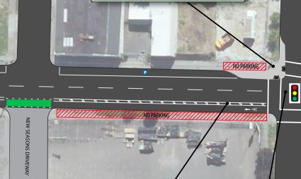
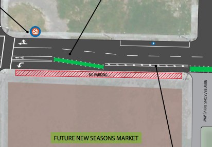
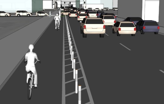
Instead of a standard bike lane adjacent to two travel lanes and a parking lane like they showed at the open house last month, PBOT’s new design for the Fargo to Fremont segment would remove on-street car parking (!) and create a larger bike lane. The design would create a seven-foot, curbside bike lane with a three-foot buffer that would come with some sort of protective element. (PBOT showed plastic “candlestick” bollards in their materials at today’s meeting, but SAC members objected to them on aesthetic grounds. It’s not clear what would be used instead.)
Here are a few graphics of the newly proposed design.
First, the plan drawings. Here’s the segment between N. Cook (to the right) and Ivy (Ivy will end into the New Seasons driveway)…
And between Ivy (on the right) and Fremont (on the left)…
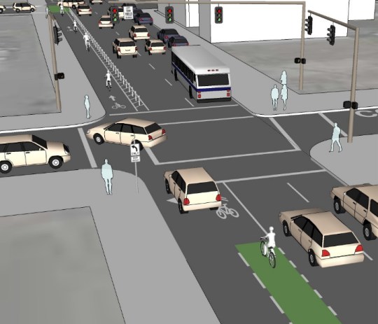
And here’s an illustration (courtesy of Fat Pencil Studio) just south of Cook…
And another illustration of the cross-section (with plastic bollards shown)…
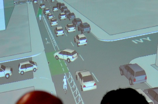
I also snapped this image of how the adopted plans will look at the New Seasons driveway at N Ivy Street. As you can see below, left-hooks will be an issue…
After a robust discussion about the merits of the design options on the table, the SAC voted to adopt this new design from PBOT. With that out of the way, the discussion turned to implementation.
PBOT project manager Rich Newlands explained that the $250,000 allocated for this project is nowhere near enough to fully fund the recommendation (which also includes money for an “honoring history” component and work on making N Rodney a neighborhood greenway). Newlands estimated that he believes $1 million is needed to complete the project. Since that funding does not currently exist, Newlands said the City has already begun to apply for a grant through the federal Transportation Enhancement program.
Whether PBOT gets the TE grant or not, construction of this project won’t start until summer of next year.
One unknown is how the Bikes Belong Green Lane Project initiative might impact this project. Portland has been chosen as one of six cities to receive support from Bikes Belong as part of the program and a recent press release confirmed that the Williams Ave. project would be one of the projects PBOT would focus on.
—
Funding and implementation aside, what matters now is that a design has been agreed on and — except for working out a few small design details — the public process is over.
It has been a very long and arduous road to this point. This is my 38th post on this project and I have to say this has been one of the most difficult stories I’ve ever worked on. While I have a range of opinions about how this has played out, I want to share my extreme gratitude for the citizens who volunteered to work on this project and to PBOT for their patience and flexibility. There will still be more to report in the months ahead, but the heavy-lifting of the public process is done.
Throughout this coverage your comments have played a key role in shaping the conversation. Thank you.
CORRECTION: When originally published, I said that level of service guidelines are “federally mandated.” That is incorrect. For more information about this issue, see this comment.



Thanks for reading.
BikePortland has served this community with independent community journalism since 2005. We rely on subscriptions from readers like you to survive. Your financial support is vital in keeping this valuable resource alive and well.
Please subscribe today to strengthen and expand our work.
“plastic ‘candlestick’ bollards”
Despite having seen these fail miserably twice on the Broadway bridge, we should try them again. The key is to expect a different result.
Jonathan: Have you seen any sort of break down of the costs for various aspects of this new design? With the huge jump up to $1,000,000 I’m guessing there is at least one new traffic signal in there. Hopefully the new plan also includes physical barriers to force left turns only from Fargo & Cook onto Williams.
I’d still like to see PBOT experiment (if only for a couple months) with a redesign achieved only with paint. I would be okay with a solution that is 5% less effective if it were to cost 95% less.
in fairness, PBoT backed away from the plastic bollards during the course of the discussion this afternoon. the conclusion was that some kind of device other than merely paint would enforce the buffer from fargo to fremont. also there was something resembling a commitment to enhance the pedestrian crossing at ivy.
hmm, what about those large rounded bumps that are used near max tracks like on SW 18th in goose hollow?
Candlestick bollards don’t hold up well to being hit by cars, that’s for sure. On Broadway, they were located within a single 8″ lane line, on the design here, they’re located within a 3′ buffer space. I suspect in this configuration, we *will* see a different result. That said, they are kinda ugly.
If we measured level of service in the movement of people, rather than vehicles, I wonder if we would have gotten a different design? How we measure “LOS” is something folks should pay attention to as we develop the new Comprehensive Plan for Portland over the next 18 months.
they were modeling projected motor traffic volumes through some near future, and they were seeing backups all the way to russell, with some impact even on people trying to turn left from russell onto williams, if you can believe it. what i think we can maybe hope for is that these volumes do not in fact materialize, and we can then look at further enhancing the bike/ped environment down the road a piece.
Chris, this is right on. When will we begin to prioritize safety, great urban design, and mobility for all modes instead of motor vehicle capacity?
When it becomes politically feasible to do so.
It is feasible now. We need a more aggressive bicycle advocacy community and stronger leadership. Both are possible.
Oh I agree with you. I was stating what is the current calculus at City Hall… not what I believe personally.
I have always believed that, if framed and executed properly, doing more and more bold things for bicycling in Portland is a political winner… Unfortunately that’s not the position our leaders have chosen to take.
And yes, our current political dynamic is directly related to our current advocacy dynamic. But there are other things playing into it as well. It’s a long conversation!
Agreed. I’m getting too old. I remember getting bike lanes on Broadway, which frankly was a much more difficult political climate. We’re going to need to dig deep and stop coasting on “Portland is so bike friendly,” if we’re going to make progress that actually counts.
I don’t believe that today’s crop of planners and advocates are interested in bike lanes on major arterials like Broadway.
Complete and total lack of leadership.
I am still taking Interstate. I only ride Williams before 3pm and long after 8pm. Once New Sleaseons goes in it will be maddening. Sorry to sound like Debbie Downer, all I see is chaos, congestion, and confusion for people in all modes. The only way this seems healthy and vibrant to me is if speed is lowered, and PPB make a presence to balance the imminent circus of dysfunction. Mark my words, it will get worse.
I’m also curious about the role that New Seasons played in all of this. Given their reputation, one might expect them to be advocates for cyclists. Given their silence, one might wonder if they pushed for changes behind the scenes.
They seemed to be OK with giving up ALL on-street parking along their Williams frontage — that seems like they are on board with the biking agenda to me. That equates to 10% of the parking they are providing on-site if I recall correctly
And how many spaces was that? And how does that trade-off play in terms of extra lanes? With respect, you understand that they are now owned by a VC firm? Their silence (and if they have spoke and I have missed it, sorry) is telling.
they have been present at several SAC meetings, and apparently they met privately with PBoT to talk about, among other things, giving up as much as two or three blocks of onstreet parking.
Good question – they’re now owned by Endeavor Capital (who also owns WinCo and Bi-Mart), so the question is how much autonomy do they still have? And how many of the senior people at New Seasons are sticking around?
endeavour capital.
winco is primarily owned by employee stockholders.
White plastic bollards : maybe we can make them look better?
Just spitballin’ here but what if they could be made to look like part of a stereotypical white picket fence?
Deploy some of that Disney style “fungeneering” to use an on street safety device, in this case plastic bollards, to make an imaginary Mayberry feel to a neighborhood thus socially encouraging people to slow down and be friendly.
I like where you’re going with this. It would seem that there are enough people out there who won’t put much effort into avoiding a collision with one of these flimsy bollards. What if, each bollard featured a plastic cut out of a cute child.
Please, no one make my neighborhood look like Mayberry.
I’d be very curious to see the nitty gritty details of the intersection analysis and simulation that PBOT performed for the two-lane part of the corridor. Predicting future trips in a scenario like this is a very inexact science, especially on a corridor like Williams, which in addition to the bike traffic has several bus lines with varying degrees of frequency. What deductions, if any, were taken from the number of projected motor vehicle trips to account for this fact? These assumptions are key–assume too few non-car trips and you’re falling into the old traps of providing too much vehicle capacity; assume too many and you’ll get hammered by reviewing agencies. Many folks are also of the opinion that standard trip-generation models, developed with primarily suburban data, greatly overstate the number of trips created by the same land uses in urban settings. Further complicating the matter, despite a stated interest in being multi-modal, Portland actually requires developers to meet _higher_ volume-to-capacity ratios than elsewhere in the state. So there are political fixes that need to occur there, as stated by others here.
All that said, I actually like what is proposed for this section currently much more than what was there previously. Replace those plastic bollards with something significant (maybe planter-type things that we’ve seen in other designs?) and this becomes a very decent facility as long as you can handle conflict at the intersections safely through smart signal design or somesuch (and that part is in good hands).
“Portland actually requires developers to meet _higher_ volume-to-capacity ratios than elsewhere in the state. So there are political fixes that need to occur there, as stated by others here.”
Brian,
can you say more about that? I think this is the crux of the matter (at least for me).
Burchfield:
“The way our planning code is written, he explained, development permits will only be issued if a certain auto traffic capacity can be maintained.”
Reading something like this is just so frustrating! Where is the vision, the leadership, the foresight?! PBOT and everyone else should be actively flagging these sorts of antiquated and frankly obsolete requirements and chasing them up the ladder or down the rabbit holes so we can be done with this sort of nonsense. Who needs this? Whom do requirements like this serve? What damage do they do in the present to outcomes and options?
Parsing his words, it would appear that after the end of cheap oil no more development permits will be issued. Somehow I doubt that.
Sorry, I got a little engineery with my description there and I think I used some confusing terminology. What I should have said was, “Portland requires developers to meet higher performance standards than elsewhere…” The way I said it before is ambiguous.
The translation is this: To develop, say, a New Seasons Market, you need to show that the intersections you most drastically affect meet performance standards. And in Portland, they are actually tighter than in many suburban & rural communities throughout Oregon (i.e., the intersection must operate with less congestion even though the density is usually higher here). This is backwards.
The New Seasons will draw new traffic, and while it’s kosher to assume some of it will come from bikes, buses, etc., the intersection performance standards are entirely vehicle-based. That’s what Chris Smith alluded to above. So if I assume that many trips to this new market will be non-automotive, I then must model these as movements that conflict with vehicular traffic, thus deteriorating the performance of the intersection. In other words, if you generate a lot of bike trips, walking trips, etc., you become a victim of your own success, in a lot of ways.
Like so many other examples, these standards are a relic of an old, auto-centric philosophy that will change eventually, but probably far more slowly than anyone would like.
A lot of those standards were also pushed by neighborhood organizations in their quest to keep businesses out of their neighborhoods and commercial districts. Particularly big-box stores, which generate the most traffic.
What about north of Freemont? Does the revised design still call for the shared left lane?
yes, that has not changed
So this revision represents an improvement to a small portion of the project. The shared left lane north of Freemont remains an overly complex, unusual, confusing and dangerous mess. We are sacrificing the basic safety and usability of the street simply so motor vehicles can be parked on both sides of the road. I hope we are able to redirect this flawed design before they find the money to build it.
Guess I’ll be using Rodney a lot more. With that annoying dog-leg you have to do at Fremont. 🙁
as messy as this plan is, it is certainly not worse than what is there now
Sorry, speaking as someone who has followed this (but no longer lives in the area so I don’t travel this street more than once a month maybe): this whole entire project seems screwed up. I can’t believe this took 17 months, what a cluster-f.
If this is about actually making people who bike along here safer, they’ve failed. They’ve removed right-hooks but have added in left hooks, and it just seems like a garbled mess of ideas that were thrown together to pacify everyone.
The bike lane has simply been moved to the other side of the street – how does this really help anyone? Now it’s next to the “fast/overtaking” lane rather than the “slow” lane.
Everyone who comments here has strong opinions, and are probably the type of riders who have no problems negotiating tricky roads. I would really love to hear what the “average joe summer rider” thinks of all this. Does it feel better, or worse?
since they are subtracting a travel lane through most of the length of williams, the bikes are not next to a “faster/overtaking” lane, they are next to the “only” travel lane.
i am not a proponent of moving the bike lane to the left, but this was done to completely remove the whole leapfrogging the bus problem, which apparently for a lot of people is a real problem. yes, you now have to contend with left hooks instead of right, and you have the added difficulty that a lot of entering motor traffic is coming from the left. but one of the largest sources, at cook, will be regulated by a light.
the shared arrangement north of fremont should be interesting to watch. it could have a substantial traffic calming effect, and it might drive away the through traffic altogether. and if the businesses survive and people can get to their homes, the whole controversy about subtracting a travel lane should fade away. laying the groundwork for similar treatments elsewhere.
Ah yes, I forgot about the leapfrogging bus issue. I guess that is a problem? I dunno. I’ve never had a concern with riding around buses, but I guess it’s never a concern until it *is* a concern, and then you’re hurt/dead.
And yeah this is just one section. We’ll see how the rest of it is received when it’s installed!
I don’t mind riding around buses, but the leapfrogging with buses is a big issue on N. Williams. The 44 and 4 have frequent service (actually increasing soon, even with Trimet cuts) and often stop every two blocks or so, and if the timing is off, you end up leapfrogging repeatedly with one bus. It’s terrible, especially when there are a lot of cyclists. The bus drivers handle it pretty well, but other drivers and bus passengers don’t always know what’s going on, and some cyclists go onto the sidewalk and some take the lane. Just the other evening on N. Williams, a bus was stopped outside the bike lane, waiting for bikes to pass on the right so it could pull over, and the boarding passenger walked into the street and the bike lane to ask if she should get on board.
….”The bike lane has simply been moved to the other side of the street – how does this really help anyone? ”
The “anyone’s” initials are N.S.M.
Leapfrogging buses was a known issue discussed by many N. Williams cyclists before NSM was part of this conversation at all.
I am well aware of the bus issue. VERY aware in fact. In 2006 a bus driver, without provocation on my part, (other than my unorthodox athleticism) was so inflamed when I took the lane, twice (between Russell and Ivy) to pass the bus, threw the contents of a beverage out his window at me. I had on another occasion watch in amazement, the shrieking and fist waving of a female bus driver directed at me (at the light crossing the I-5 s.on ramp @ Rose Q.) while I was WAITING for the light to just turn green. I was not even moving! I am one that try’s to be (for the most part) a decent ambassador for cycling while I am out and about. I share this with you in the hope that you will trust that in both of these cases I did nothing to provoke, other than being a cyclist. I have been a bicycle commuter since 1977. If by chance there is any motivation behind your comment that assumes I am somehow uninformed on the situation around N.Williams, I can reassure you that is not the case. Thus the reason I pick other routes through this area, most of the time.
@ Daisy, BTW the shrieking fist waving bus driver was losing her cookies at me on a Sunday afternoon around 5:00. There was no event at the R.Q. and traffic was as thin as the hair on my ol’ Granddad’s head. Granddad btw, grew up in a lil’ ol’ town like Mayberry. It wasn’t so bad there, in fact I kinda liked it.
Actually, I was just responding to your suggestion that New Seasons had something to do with this. I’m afraid you are reading a lot more into my comment than is there.
Apparently J.M.thinks so too. sad.
I have been meditating about the deadly crash at 3rd and Madison last month; the ghost bike there is beautiful and entirely appropriate. There is more than enough responsibility to spread around; specifically, what role did “green paint engineering” play?
Here is an idea: forget about white lines, green paint, and all those lovely bollards; require and enforce vehicular cycling downtown, perhaps re-timing the signals to lower speed a little so cyclists can keep up with motorists.
Just a thought. Might work on Williams too.
It will work out great if your standard for working is to chase away all but the most committed cyclists, and take the cause of cycling in Portland back about two decades.
I’d agree wholeheartedly with you but that requires signals at every intersection to regulate traffic speeds to ~12 mph as we see in Downtown. I think we also desperately need something like this on Broadway/Weidler, MLK/Grand, and Everett/Glisan, the latter two couplets especially because there are no bike lanes.
Yes! more signals might do it. The MLK/Grand couplet is an example of how signal timing doesn’t work. The signals are timed for something like 20 mph (which is still too fast) but because of the disjointed spacing, people will speed quickly between signals, making those middle blocks pretty useless for people crossing the street.
If the goal is a slow, urban, walkable, bikable street, you should have signal control on every intersection you can, timed for appropriate speeds.
I disagree completely. Signals are extremely expensive (I’ve heard about $250,000 per intersection), aesthetically unpleasant and reduce efficiency of all modes — including walking — when used excessively.
As far as I know, “a slow, urban, walkable, bikable street” is not the goal. If it were, the obvious solution is to remove all motorized traffic.
MLK-Grand is timed for 30 mph, progressing on the yellow phase.
Actually, Everett/Glisan has been or will be retimed soon for a pretty low speed (I think closer to 15 than 12, but lower than current). This was part of the discussion around the Pearl District Access and Circulation plan.
I was going to comment on the post generally, but Brian Davis said everything I was planning too, but better and with engineering!
Climbing that route on a heavy cargo bike with kids onboard does not allow me to keep a pace acceptable for vehicular cycling strategies to be civil or reasonable. 12 is too fast. 9 is more like it. Separated facilities are needed to allow less-athletic riders to bike full time, wherever they need to go.
The primary attribute of a roadway should be safety. Flow & capacity at the expense of life & limb is egregiously immoral and should be framed as such.
Welcome to America.
Ah. I’m reading this as, “It’s over. Finally.” As in, Williams is over as far as a comprehensive commuting option.
Guess I’m one of the ones who has also been moved over to Interstate.
Maybe I’ll try out these new designs sometime, but for my regular commute it will remain Interstate.
Past posts are correct – the existing models are very suburban mid america based – so how about PSU developing more urban based trip generation data? How else will Portland ever reach it’s~25% bike mode split.
Perhaps it’s time to set up some $200 time lapse SD cameras and see the mode split at their existing inner city markets?! I think that the auto mode split would be lower than 90%.
A camel is a horse designed by committee. This one looks like it has three nostrils and a unicorn horn on it! But it has to be an improvement even if all it means is a larger bike lane…
Jonathan, with all the changes that have been proposed over the months, I’m not quite sure of the full configuration from Broadway to Killingsworth any more. Is there a drawing or presentation available that covers the whole street with all the latest changes?
i hear you dsaxena. I will do a separate post that lays everything out. Or, you can always check the project website where they have PDFs of the adopted plans.
I’m really curious to see how the shift from right bike lane to left bike lane (from N Williams at Weidler to just past Broadway) is going to work. A lot of car traffic is getting on I5 there, but many cars do go straight onto Williams. I’ve seen lots of potential right hooks just north of Broadway as cars turn into the service station, and the concept drawing at least doesn’t show how a car is going to be able to negotiate that spot very gracefully. Unless there will be separate bike and auto lights at those intersections?
they have placed a dual width bike lane up the center over the bridge, with northbound motor traffic to the right and highway exiting traffic to the left. there is a large bike box at broadway. the bike lane then follows the highway exiting lanes to the left edge on the other side of the intersection.
I saw a drawing of it. I’m just wondering how it’s actually going to work in practice.
this is close to the final configuration, except for the stretch from fargo to fremont
http://www.portlandonline.com/transportation/index.cfm?c=53905&a=398936
Having attended one of the earliest meetings on this (before it was even considered controversial), I’m glad to hear they’re describing a design as, “final.” At the very first meetings, people were asking for a left-lane bike lane and to remove parking if we were to have two car lanes. It took a while, but I’m glad to see that actually may happen.
This is a triumph in protecting on-street parking and car traffic!! The money spent on this project should be counted as money to preserve on-street parking and car traffic volume. This should not be paid for with money dedicated to bicycle infrastructure or tallied as money that Portland spends on bikes.
Or at least allocate the money spent as proportional to the width that each mode gets at each block of the project. For shared lanes, that width is split based on the average weight of each mode. Thus, the whole project would wind up as being about 80% auto expense, and 20% bike expense, at worst.
But of course, it’s the wrong way to think of it. “Complete streets” should be the necessary minimum standard, and be considered a transportation expense with no mode-share accounting. In the same way that we don’t break out the costs of an office building by how it was designed for male or female occupants, we should not break out the costs of fixing a broken street by the machine each person uses on that street. I’m pretty sure Jonathan would agree to this.
I have missed something in these 38 postings – can someone explain why there are no bike lanes on the right side? What are the options for making a right turn?
You can either merge with the general traffic lane to prepare for a right turn, or make a two-stage right turn, just as you see on the Broadway cycle track near PSU (except those are left turns). Green boxes can provide a refuge area for those waiting to make a two-stage turn.
I can do that – but still – why the left bike lane and not the right – or better, why can’t there be 2 bike lanes on a one way street? Is there an engineering reason for this preference? Is the left lane considered a better and safer option for one way streets? Just curious about this set up. My bike mirror is on my left side – perfect for being in the right lane but not so great for a left bike lane.
It’s over, don’t worry, we have you covered It will be awesome! You will like it, relax.
looking forward to it! 🙂
This configuration is supposed to be safer at least in a statistics sense. The odds of a door opening on the driver side are 100% per parked vehicle. The odds of a passenger side opening are more like 50%. So in theory fewer cyclists getting ‘doored’.
there was widespread concern that the interested but anxious or whatever the phrase is could not handle leapfrogging buses
That’s why I have mirrors on both sides of my helmet, I sometimes have to take the through lane with the right turn lane to my right and some people try to use the right turn lane to get past me (even though they are aimed right at a curbed median…)
Buses. That’s the issue.
“Development permits will only be issued if a certain auto traffic capacity can be maintained.”
Sounds like the official city plan of taking steps to drastically reduce the amount of trips made by car by 2030 is in conflict with the development permit process.
On which side do you pass in a left hand bike lane?
I would argue that passing on the right is the appropriate method. The passer should be leaving their lane and merging with other traffic in order to pass. If the passer passed on the left they’d be forcing the passee into traffic.
Unfortunately all other passing scenarios I can think of call for passing on the left so I’m sure we’ll see plenty of both.
By “pass/fail criteria” Burchfield is referring to federally mandated “level of service” guidelines, which dictate how long cars should sit in traffic and often force cities’ hands in maintaining and/or expanding auto capacity.
To help make his case, Burchfield played an animated simulation of auto traffic in the Williams corridor with both the one-lane and two-lane configuration. In the one-lane scenario (with the planned traffic signal at N. Cook), auto traffic would back up in several sections during the two-hear PM peak. With two lanes, auto traffic flowed much more freely.
Wow, that’s almost the exact same thing Burchfield said/did 12 years ago when rejecting the addition of bike lanes and a change in the lane configuration on Hawthorne Blvd. during the final discussions of the Hawthorne Blvd. Transportation Plan.
So much for progress….
🙁
Jon, there is a minor but vital error in this article. Vehicle level-of-service standards are NOT federally-mandated! The Highway Capacity Manual (and AASHTO Green Book) contain GUIDANCE approved by the Federal Highway Administration and AASHTO. It only becomes STANDARDS if the state or local jurisdiction adopts it as such. For example, ODOT uses a volume to capacity ratio standard instead of level of service. Portland currently uses a level of service standard, but it is a local policy issue whether they use an LOS standard of “D” or “F” or throw LOS out the window all together. This understanding is vital if we are ever going to gain the momentum necessary to change a system that engineers and public agencies have been relying on since the 1950s. To their credit, both ODOT and PBOT have been exploring alternative performance standards that take into account the needs of more than just cars.
Thanks Jessica. I’ve edited the story and issued a correction at the bottom. I really need to delve into that issue and present a separate story about it.
I like how every car in the sketchup renderings looks like a Subaru Outback. This is actually probably a very realistic prediction!
What a mess. I ride Williams home every day from work, and will now plan on just taking the right-hand lane the whole way rather than dealing with the dangerous and confusing design being implemented here.
Let it be noted that too much bickering results in nobody getting what they want.
But how would it have played out if a church, apartment building or a multi- unit Eco-friendly condo, or (god forbid) affordable homes went in as opposed to NSM ? I certainly understand your point. PBOT ,the city, business,and the community could hash this out forever, and it would never be ideal. Despite the fact that it seems compromised in a few ways, perhaps it will be awesome. We will see.
How do I put this eloquently? If the infrastructure puts me at risk, I’ll be taking the lane and I doubt that I’ll be alone. The reality is that cyclists shouldn’t be treated as second class citizens. When the culture shifts such that the term “traffic” includes bicycles as the assumed default, then we’ll be getting somewhere. The right-hook/left-hook concerns are real. The entrance to New Season’s will be a very active driveway.
In the potential right-hook-with-a-bike-lane scenario, drivers tend to do one of two things:
Don’t stop, leaving the cyclist to take evasive action or get hit
or
Stop to let cyclists pass but do so at the very last moment, often with wheels just beginning to turn.
The problem with the common 2nd possibility is that the cyclist’s decision to proceed or not is pushed to the very last millisecond and often involves trust and hope where it’s high risk to do so.
With the kind of {bicycle} traffic on Williams and the expected grocery store traffic moving in/out, different cyclists will “read” the turning traffic differently as they approach the same place. I anticipate fast aggressive riders to thread the needle while more conservative or slower riders to hesitate or stop. This creates threats from behind and from the right. This will be problematic.
I see your interpretation as sound, your projection of future scenarios as prophetic, Sir are a true voice of intelligence here! There are those that only see cars and buses as the problem. I applaud you !
With the sophistication of computer modelling, I wonder if how people actually drive has been algorithmized? Even auto drivers should be considered intelligent, such that as congestion develops to a certain point, they find alternatives.
Ever notice how when there is a sudden and unexpected road closure [bad accident, crime scene], that there is surprisingly little congestion around it? We have a street grid that allows a myriad of alternatives, and people are smart enough to figure this out quickly.
I didn’t see the one-lane/two-lane modelling comparison, but real world reactions of drivers seem to result in clever alternate routes … and avoidance of chronic problems in the long run.
With a known restriction, one could expect even better accommodations by drivers. I have not seen any evidence that quiet neighboring streets become inundated with traffic over the long run, as many fear.
As Jonathan has mentioned previously – and I don’t hear many others saying it – we need to ACTIVELY DETER auto use, not accommodate it, to make real progress toward safe, livable streets. This can be achieved by good design.
And in a nod to 9watts, the end of cheap oil will result in plummeting VMT’s in the not-too-distant future. And yet we’re still bowing to the automobile – more 20th Century thinking.
I am confused about the city’s comments about having vehicle congestion guidelines they have to follow. I don’t believe this is true.
The State of Oregon requires them to meet a vehicle congestion threshold before upzoning, section 0060 of the Transportation Planning Rule. Section 0060 is much maligned because it makes urban density impossible. However, existing zoning is safe under TPR 0060, and I don’t think zoning changes are proposed on N Williams, so TPR 0060 does not apply. Rather they are looking at new development with the existing zoning. PBOT does not require traffic studies for these types of development, and so congestion is not considered.
So are they really talking about PBOT electing to keep more capacity due to negotiations with New Seasons? The details of the decision seem to be misrepresented here.
If the street is so busy that they have to keep lanes and sacrifice bicycle facilities, then it’s time to remove the parking.
@ d’wdibbly,.. I could not agree more, but IMO..
The car user in Portland suffers the same strange syndrome that I have seen in communities the same size around the nation. They have to street park within 100 feet of their destination or they go somewhere else. In Chicago, if you want to eat or drink at a certain place. more than likely you will have to park 8 BLOCKS (REAL city blks. btw) away, and walk in the freezing wind blast to get there. Portland is just like Kansas City and Austin and a couple other places, where if there is not a PARKING lot, people freak out. Retailer will fight tooth and nail over this, as we have more than likely heard here before, so don’t hold your breath. Now cyclists on the other hand know better, and are rarely diverted from going places due to this.
Here is an alternative to “candlesticks” just posted today.
http://www.cyclelicio.us/2012/rubberized-cycletrack-barriers
I just don’t see traffic moving away from Williams. Today I saw a 4 block line up of cars at 1 red light on MLK. People are going to still seek alternatives to MLK, Interstate, Greely and especially I-5. Perhaps finding a better way to control traffic speeds would be a better idea. Perhaps they could retrofit the buses with left side doors and put them on the other side of the street? (just trying to think outside of the box).
Vancouver and Williams move nearly the same amount of traffic right now. The most significant difference between the two is speed on Williams. It is often 5 mph more than speeds recorded on Vancouver. The difference can be accounted for by the number of lanes on each street. Vancouver is mostly one lane, while Williams is 2+.
This is a big improvement for the Cook-Fremont section, much better than the plan presented at last month’s Open House. Thanks, PBOT!
If you missed it, Susan Peithman’s BTA Blog post did a great job at articulating the problems with the previous Cook-Fremont design, essentially calling it a “no build” proposal, and stating that all along the committee affirmed that “No build is not an option.”
http://btaoregon.org/2012/05/fargo-to-fremont-were-not-done-with-williams/
Ted Buehler
Jonathan or SAC members —
There were two other major “downgrades” to the corridor from the Committee’s recommendation in April to the Open House last month.
1) “No build” at Graham, with the middle island — bikes would still be in a super skinny bike lane, only now it would be on the left, not the right.
2) “Shared Lane” extended from Skidmore to Alberta. Originally this was just for the high-car-traffic section from Cook to Skidmore (where Williams acts as an eastbound street for traffic going from I-405 to NE Portland). But now its extended all the way to Alberta, almost half of the project area.
Thanks,
Ted Buehler
at the SAC meeting the other day i mentioned the problem with the diverter at graham, which would now put the bike lane inside a forced left turn, and when i said this was road engineering 101 rob burchfield nodded in agreement. so i think they will be addressing that, possibly by moving the diverter over to the east leg of the intersection.