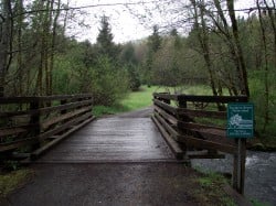
(Photo: Evan Ross/Portland Bicycle Tours)
Travel Portland has announced that the Banks-Vernonia Trail is a recipient of a 2011 Tourism and Hospitality Industry Award.
Travel Portland recognized the trail with a “President’s Award,” for, “creating a new opportunity for our visitors to experience the natural beauty that is so accessible from Portland.”
The trail is a 21-mile linear state park created on a former railroad line between Banks and Vernonia. As of last October, the entire length of the trail is complete and offers people the ability to roll or walk the entire route without worrying about motor vehicles.
The trail has quickly become a major destination for Portland-area bike adventurers. In a nod to its popularity, we’ve heard about one local company working on a shuttle service that would bring people and bikes right to the start of the trail (more on that later).
The award will be presented at a breakfast at the Oregon Convention Center on Tuesday, May 10th.


Thanks for reading.
BikePortland has served this community with independent community journalism since 2005. We rely on subscriptions from readers like you to survive. Your financial support is vital in keeping this valuable resource alive and well.
Please subscribe today to strengthen and expand our work.
Yes! I am going to be riding the entire thing over Memorial Day weekend and bringing my tourism dollars to the coast range foothills and the communities of Banks and Vernonia. 🙂
Meant to say, *looking forward* to riding the entire thing etc.
Is the whole thing paved now? Wasn’t there a gap in the middle that was dirt?
I had the same question — has anyone ridden it recently?
Yep, I’ve ridden it three times this year. Paved the entire way. Nice ride.
Cycle Wild road it a few weeks ago. There are a couple of dirt-road crossings where you will be on gravel for about 20-30 feet, but the path itself is entirely paved now.
It’s paved for the entire length. Where the old steep descents used to be at Tophill, there are new switchbacks. (still steep, but not AS steep) There are signs asking cyclists to walk bikes on those hills, and if you’re not an experiences rider, you’re best off following that advice – the switchbacks can be hazardous if wet or icy. As of a couple weeks ago, there was still the occasional bit of snow up there, but the trail is clear now.
If one were to desire to ride said trail would one find the easiest way to get there by traveling on max then bus to forest grove and riding north on Nehalem Highway? I know north plains will ticket if you don’t put foot down at stops since their podunk little town clerk stole 100’s of thousands for years(maybe over a million) of cash receipts from their ticket program. I’d like to get to the start of the trail as fresh as possible to speed through in case danger lurks(and what killer wouldn’t pick his spot to do his hobby on a lone trail with no help?)
there’s a good route right out of Hillsboro, so you don’t need to mess with the bus – select route 1, map 1:
http://www.portlandonline.com/transportation/index.cfm?c=36638&a=301633
the map also shows the spots where serial killers congregate, if that helps.
I feel that the best way is to take the MAX to the end of the line in Hillsboro and ride the approx. 12 miles through quiet country roads to the trailhead in Banks.
Easily done if you follow this map provided by PBOT:
http://www.portlandonline.com/transportation/index.cfm?&a=316549&c=36638
If you are too apprehensive about riding on a lonely trail, you could always use Hwy 47 and put up with the traffic. But if you use the trail on a nice day, you are bound to see other people enjoying it.
I understand that Columbia County Rider (www.columbiacountyrider.com) offers shuttle bus service between Willow Creek/SW 185th transit center and Stub Stewart State Park.
See http://tinyurl.com/3japszj for schedule and information.
Thanks all for the information. One more question: is the trail suitable for training rides (say, 16-20 mph range) on a road bike? I’m thinking primarily about width and how many walkers there are…
“…and offers people the ability to roll or walk the entire route without worrying about motor vehicles.”
Not quite accurate. There are a few places where the trail does intersect a motor vehicle road.
Pedal Bike Tours has shuttle service available- .50/mile per person with a $100 minimum each way (other destinations welcome). We can drop you at Vernonia for $22/person and pick you up at Banks for $11 or you can ride from Banks to the Max at Orenco Station (11 mi.). We did this for some Canadians earlier this year and they loved the trail.
Please keep in mind that this a muti purpose trail that is used a lot with horses as well as walkers, so keep that in mind when riding it on a bicycle. Safe speeds would be 15mph max. Startled horses can do a lot of harm to people. I will be riding this trail soon on my bicycle at safe speeds to enjoy the quiet and scenic wonders of nature and looking for any signs of the local cougar sightings and other wildlife.
Enjoy
Totally second that emotion.
Safe speeds could be higher than 15mph, depending on circumstances. There are large segments of the trail with great visibility where one could travel 20+ with no problems whatsoever, and others where anything above 10mph is dangerous. Rather than arbitrate a speed, I would recommend GOOD JUDGEMENT. Pay attention, and reduce speed when near pedestrians. 10mph is probably the maximum safest speed near horses – horses are large, heavy, potentially dangerous animals – some of which on this trail can be easily spooked. When spooked, they can easily injure themselves or others. Be kind – if you see a horse, slow down, give it a WIDE berth (they are supposed to be on the unpaved “woodchip” area adjacent to the trail – hug the opposite side of the paved portion and give as much room as possible), and respect other trail users.
Usually, there isn’t a lot of traffic except for the first couple of miles past Banks, and near the major trailhead access points. Obviously, traffic will be heavier on weekend, during summer, and heaviest on the major holiday weekends. The B-V Trail is *not* the Springwater – nowhere near as busy. Just remember that there are other users – stay alert, and keep to reasonable speeds.
And if you have brakes that squeal, get down to a slow speed sooner rather than later. A squealing brake pad can spook a horse and send the rider flying (and for your own sake, get your brakes tuned up so they stop squealing. Excessive brake noise is a sign of worn or improperly aligned brakes and are a safety hazard.)
just wondering whether you have you actually observed a cyclist flattening pedestrians and spooking horses…
You’re saying it has to be an established problem before we can ask people to be respectful and not a jerk?
If you’ve never seen a cyclist spook a horse, you haven’t ridden your bike around many horses.
your comment does not address my question:
has anyone seen a cyclist buzz a pedestrian or spook a horse on the banks-vernonia trail?
You didn’t specify the V-B trail in your first question, so I think RRR pretty much answered it.
RRR is correct.
I’ve ridden B-V up to the switchbacks & back on a few different occasions. Seen about 4 horses total, and maybe 20-30 hikers in that time (okay, so I was riding in January & it was cold out). Very easy to cruise at 20+ on this trail, so long as you go real slow when passing people & horses. Be especially careful going over the wooden bridges, since they don’t always mesh well with the trail, and at least one of them has a fairly significant little ramp going up to it.
I see horses on B-V almost every time. Be sure to use plenty of verbal warning signals when passing horses. Unless they have been around bicycles (unlikely) they don’t know what you are unless you make human noise. Bells are not good. And pass slowly….
Ditto on being careful on the wooden bridges. The little ones seem to have the worst transitions.
Are the posted mile markers accurate on the B-V Trail?