

local geologic mysteries.
(Photo by J.R.)
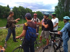
I ditched work on Thursday to familiarize myself with the Land of Port a bit better by joining up with fifteen other people on bikes and Dr. #1 Badass (planetary geology professor) at the Washington Park Zoo MAX stop.
The four and a half hour tour began by reviewing the excellent MAX station display of a drill core sampled during construction of the Red Line. Its corresponding timeline set the framework for our understanding of the geologic development unique to this region and foreshadowed the stops we would make later in the afternoon.
Professor #1 Badass, currently teaching at UNLV, was a genial and informative guide who enthusiastically answered a litany of interesting questions posed by ride members. We discussed the slow motion drift of the Zoo area, explaining why it is a better location for a park than a housing development. We witnessed the result of a recent landslide then bombed down to Burnside and 24th to see the fault line which defines the edge of the west hills and plays an important part in the Cascadia Subduction Zone.
From here, we traveled to the west waterfront and heard how human attempts to control the river allowed a downtown to exist in a relatively dry state…for now.
Then it was off to Sullivan’s Gulch to hear from local historian Shawn Granton about the long term and near term development of the area starting waaay back when the entire region was under water and the Gulch developed as a submerged channel; the path of least resistance for water, silt and house-sized bits of debris. In the blink of time witnessing modern development, this area is the path of least resistance in which to locate transportation lines.
Remaining riders ventured on to Alameda Ridge. After a brief stop on one of Alameda’s hidden stairways we were off to Rocky Butte (by way of Annie’s Donuts, who opened up specially thanks to Rev. Phil’s masterfully pathetic plea) to climb up the volcanic feature and get the big picture of the Cascade Range, the Willamette and Columbia River Valleys and the skyline of the West Hills. Participant Steve won a free burrito coupon from BikePortland sponsor, Laughing Planet for his enthusiastic participation and endurance. He called this ride the most informative of Pedalpalooza thus far.
A little tired but full of donuts, we bombed back down feeling more knowledgeable about the geologic history of the Northwest and encouraged to live for the moment because the cataclysmic events that shaped this place are not taking the day off for Pedalpalooza.


Thanks for reading.
BikePortland has served this community with independent community journalism since 2005. We rely on subscriptions from readers like you to survive. Your financial support is vital in keeping this valuable resource alive and well.
Please subscribe today to strengthen and expand our work.
Of course, after the “big one” hits, a sturdy bicycle will be the best transportation option in these parts. Some bridges will crack or fall (including all the little ones over creeks and gullys that you rarely notice) and landslides will punctuate roads in the hills. Cars won’t be able to get through. Walking takes a long time. But a good bike will breeze along the remaining open roads and can be easily walked over or around the bad spots.
So toss some heavy duty tubes in along with the water, food, batteries and first aid supplies in your emergency kit.
Just a little ‘glass half full’ thought about the day after the big quake.
so NOW are you going to join the Piedmont NET team Jonathan? http://www.pdxprepared.NET
Wow, this sounds like an awesome ride! I’m sorry I missed it… is there any chance of a reprise, if not this year then next year?
The Geological Society of America national meeting is coming to PDX in late October. I think we’ll run another one that week. Keep and eye out for a posting on the shift calendar.