(Photos © J. Maus/BikePortland)
The Oregon Department of Transportation (ODOT) has had quite an eventful week.
Last Monday they released a long-awaited safety audit of Southwest Barbur Boulevard. Then mid-week we learned they had made huge progress on two projects: restriping North Lombard to include bike-only lanes and the completion of their North Denver Avenue project. Then on Friday Metro President David Bragdon took the gloves off and leveled harsh criticisms at the agency both in the media and during a big speech at City Club.
We’ll have more coverage on all those fronts. But for now, let’s focus on the changes ODOT has just made to North Denver Avenue.
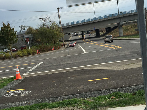
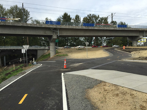
Denver is a key north-south coridor in North Portland. It serves not only as the Kenton neighborhood’s main street, it also provides a bridge over Columbia Blvd and connects directly to Portland International Raceway (home of year-round bicycle racing) and the wonderful paths along the Columbia Slough.
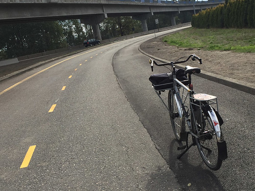
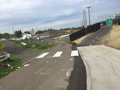
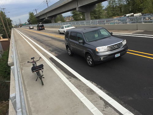
ODOT’s $4 million project focused on a 0.75 mile stretch of Denver between N Argyle St and N Victory Blvd. Here’s what the project included from a bicycling perspective:
- New eight foot wide buffered bike lanes (six foot lanes with a two foot buffer) on Denver between Argyle and Schmeer (including a bonus section north of Schmeer in the northbound direction)
- A new, six-foot wide physically protected sidewalk on the northbound side of Denver over the bridges over Columbia and the slough.
- A new multi-use path from Schmeer road to Victory Blvd (about 0.3 miles) on the western side of Denver.
- People are no longer allowed to drive on the section of Schmeer Rd that used to loop under Denver. This is now only open for bicycling and walking and it connects the new path to PIR and the existing paths along the Columbia Slough.
- New traffic signals, sidewalks, paths and marked crosswalks at Schmeer and Denver.
- New bicycle wayfinding signage.
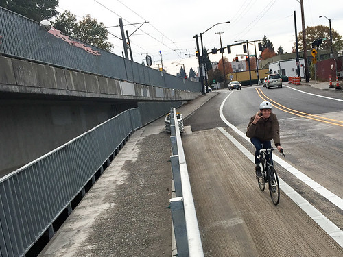
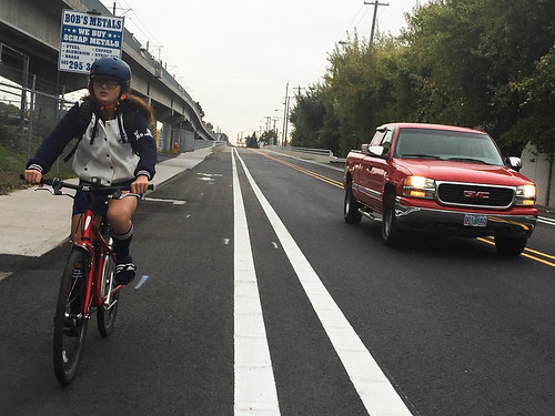
This is a lot of bike stuff for an ODOT project! And they help make this area much safer for everyone! But how’d ODOT do on the fine-grain details? On Saturday I rode the entire project to take a closer look.
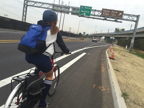
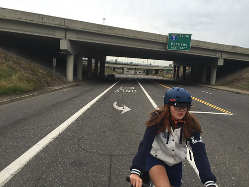
In a nod to how crucial Denver is in connecting people with the many important destinations north of Kenton, I rode it on Saturday with my 12-year old daughter to a soccer game at Delta Park. Here’s how that went…
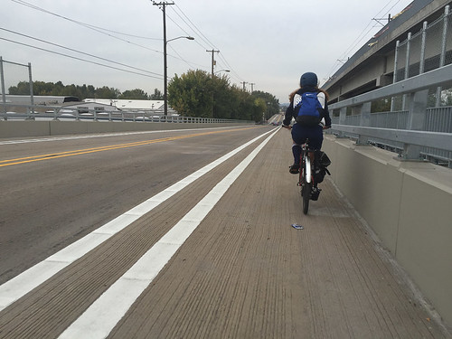
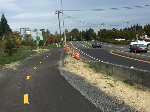
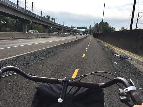
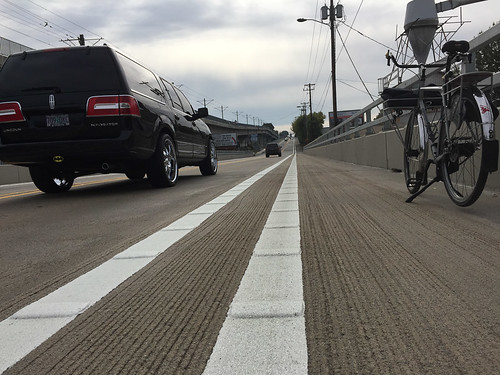
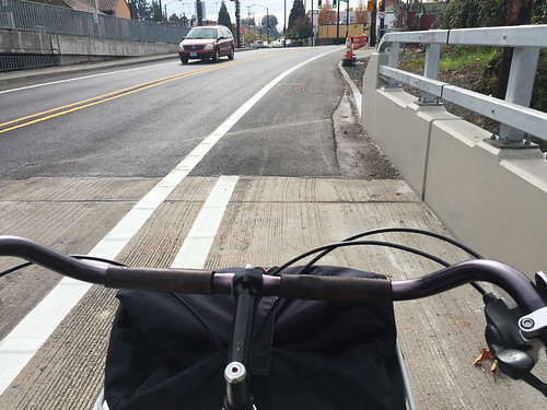
The new bike lane starts out just like the old one, without a buffer. But I like how ODOT installed raised bumps inside the paint stripe (scroll down for a closer shot of them):
While those bumps and the buffer (where it exists) are nice, I’m bummed that ODOT chose to only protect the sidewalk and not the bike lane. With a clean slate to work from, it seems like a missed opportunity to not provide a protected bike lane the entire length of this project:
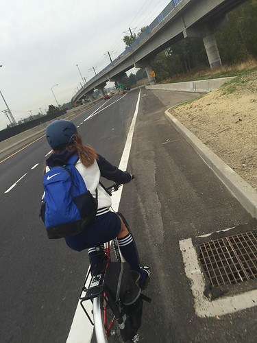
The new protected sidewalk is only six feet wide, but because it’s safe from fast-moving traffic it’s going to attract people on bikes:
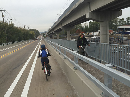
People on bikes are just as vulnerable to auto traffic as people on foot:
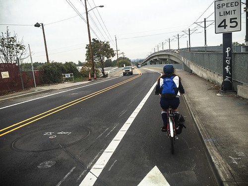
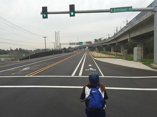
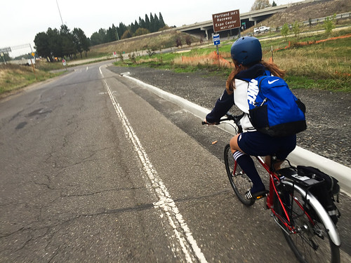
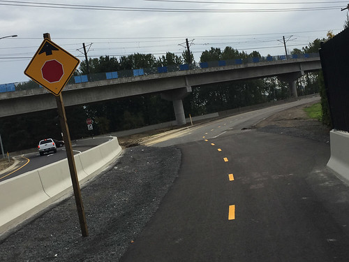
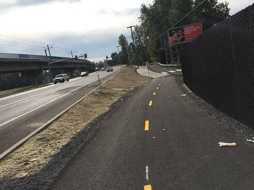
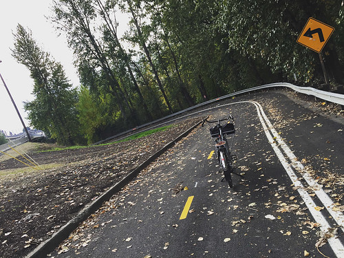
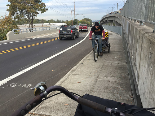
The new signal at Schmeer is helpful. It will tame speeds and it comes with marked crosswalks. The new buffered bike lane continues north of Schmeer as you head toward Victory Blvd:
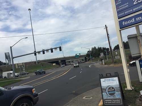
Now watch what happens as you approach Victory Blvd (Denver ends into an I-5 on-ramp here). First, the buffer ends:
Then the quality of the bike lane deteriorates as it becomes narrower and grates pop up:
That’s Victory Blvd in the distance and you can see that ODOT has all but given up on the bike lane:
And here’s where the new buffered bike lane ends up. That right-turn arrow on the left directs people up onto the I-5 freeway:
The end of the new bike lane on Denver at Victory Blvd (as shown above) is just 0.11 mile to the entrance of Delta Park, a major destination with 12 soccer fields, many baseball diamonds, and the main path people take to get to Vancouver. It would have been amazing to connect the new bikeways on Denver to Delta Park instead of making people take the lane in this very intimidating section of road:
This is the view from the entrace to Delta Park looking back toward Denver. This 0.11 mile stretch is a bummer of a gap:
Now, let’s ride south back to Kenton from Victory Blvd.
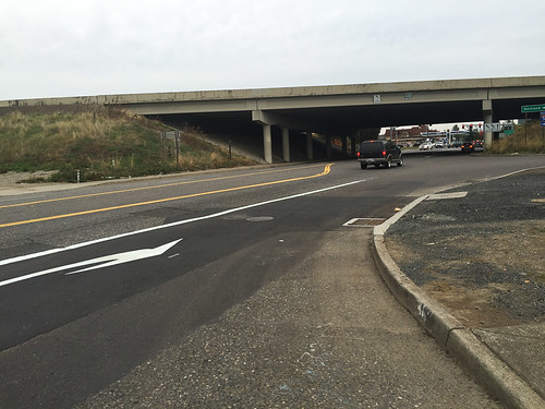
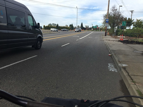
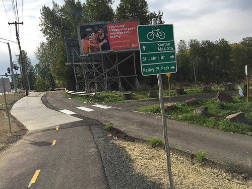
The gap between Delta Park and the new multi-use path adjacent to PIR is 0.2 mile. Here’s the view approaching N. Expo Road and the new path:
Looking back east at Expo Road and Victory Blvd at the end of ODOT’s new path:
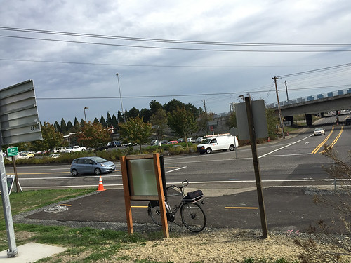
A bit closer up. Wouldn’t it have been great to create a bikeway on Victory to make this crucial connection?! (I’m also a bit disappointed that ODOT didn’t take the new path all the way to the actual entrace of PIR. Now folks have to either ride in the grass, or enter the roadway, cross the street, then cross again a few hundred feet north):
Looking north where the path ends at Victory Blvd:
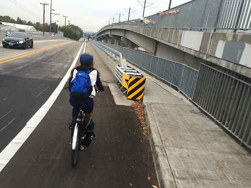
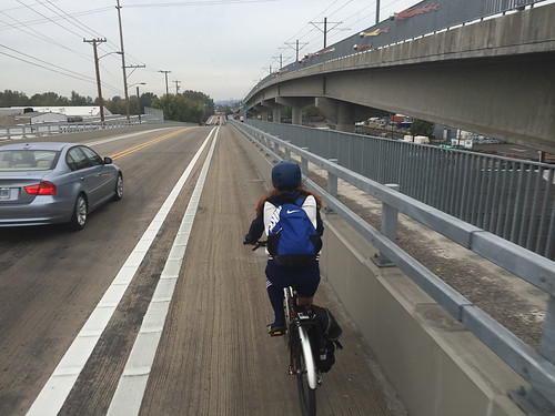
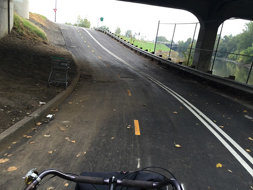
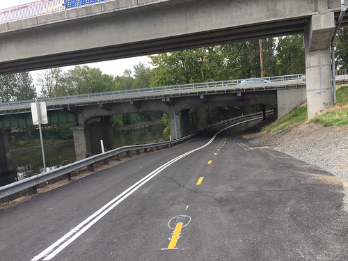
OK, back to the good news. The new path from Victory Blvd north toward Schmeer is fantastic!
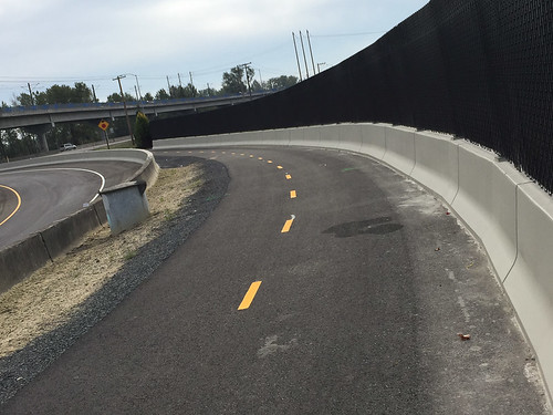
ODOT built a new road for auto traffic (on the left), so that means the new path is super-wide in this section because it’s actually using the old roadway:
Advertisement
Here’s where the path begins to dip down to connect to the Columbia Slough path west of Denver:
New signage:
Looking back (north) with the Columbia Slough path on the left, an unused entrance to PIR in the middle, and the new path on the right:
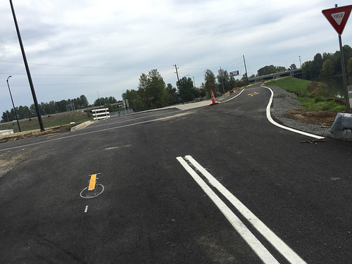
And then one of the best parts of this project — Schmeer Road is now carfree:
Going under Denver toward Columbia Slough path eastbound:
Right takes you to Columbia Slough path:
Looking back (west) at Denver from Columbia Slough path:
And the carfree Schmeer section looking west:
As you can see above, the new striping of the carfree section of Schmeer looks like a typical road. That’s problematic because I think many people won’t understand that the lanes separated by dotted yellow are for cycling and the white shoulder lane is for walking. I think ODOT should strongly consider adding large pavement markings to make it clear where to ride and walk. (UPDATE: ODOT says they had to maintain standard striping like this because of the lease that Portland Parks & Rec has on the road. PP&R runs PIR (the racetrack) and this road is still going to be used by the racetrack operators during some permitted events).
In the video below I show you how fantastic this new connection is (and you can see how lane-use needs to be a bit more clearly defined):
Back up on Denver Ave, the new buffered bike lane starts right at Schmeer:
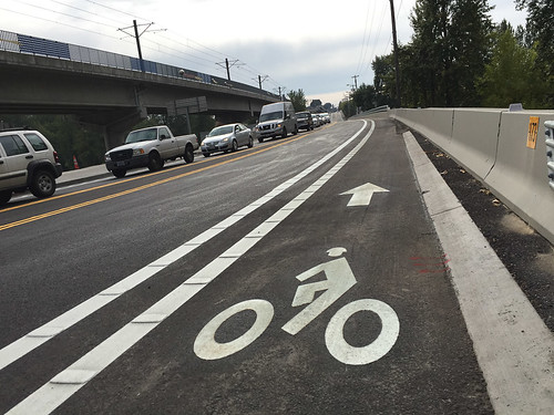
Here’s a close-up of the buffer and those raised bumps I mentioned earlier:
Unlike the east side, there’s no sidewalk on the west (southbound) side of Denver. Here’s how the cross-section looks from above:
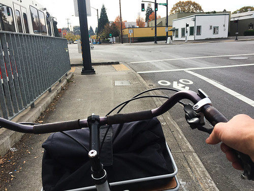
The buffer ends as you approach Argyle and make your way into Kenton’s commercial district:
Now that I’ve shown you all the new bikeways, I want to share a few more thoughts about the protected sidewalk. Because it makes such a great — and physically protected — connection to the Columbia Slough path and the newly carfree Schmeer Road, I have no doubt a lot of people will ride bikes on this sidewalk. That’s not entirely a bad thing. However, the sidewalk is only a smidge over six-feet wide which means there’s not a lot of room to pass people on foot much less other people biking.
Another issue is that when people use this sidewalk to get back into Kenton, they’ll come to this awkward intersection with Argyle that will put them back onto the roadway in an unexpected place:
The other issue with the sidewalk design are the bolts ODOT has left sticking out of the guardrail. They’re several inches long and unfinished. I actually saw two men pass by each other on the sidewalk. One was biking, the other was walking. The man walking moved over and his jacket snagged on one of these bolts:
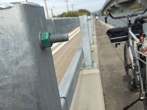
If your arm grazes one of these while biking by it will result in a nasty cut. With all the traffic this relatively narrow sidewalk will get, ODOT might want to consider filing these screws down.
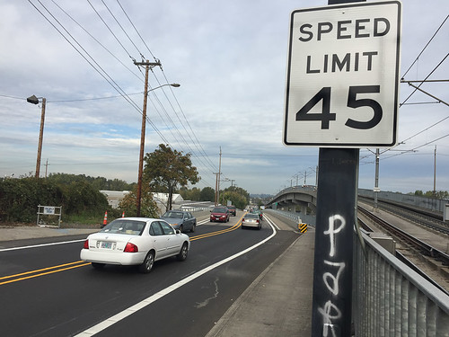
And one final thought. Now that this section of Denver has been designed to encourage bicycling and walking, its 45 MPH speed limit is way too high (especially next to 12-foot wide lanes):
Despite my quibbles, there’s a lot to celebrate with this project. I just hope in the near future we can get more protected bike lanes and have those lanes connect to important nearby destinations like Delta Park and the shopping center at Portland Meadows (N Whitaker Ave. is in dire need of better bike access).
For more information, check out ODOT’s official project page.
UPDATE, 3:05pm: ODOT says the bolts extending into the sidewalk are already on their radar and issue will be resolved.
— Jonathan Maus, (503) 706-8804 – jonathan@bikeportland.org
Jonathan Maus (Publisher/Editor)
BikePortland founder. Father of three. North Portlander. Basketball lover. If you have questions or feedback about this site or my work, contact me via email at maus.jonathan@gmail.com, or phone/text at 503-706-8804. Also, if you read and appreciate this site, please become a paying subscriber.


Thanks for reading.
BikePortland has served this community with independent community journalism since 2005. We rely on subscriptions from readers like you to survive. Your financial support is vital in keeping this valuable resource alive and well.
Please subscribe today to strengthen and expand our work.
That cycle path looks fantastic, and unlike the PBOT cycle paths, actually has a centerline. I have no idea why PBOT (or Parks) doesn’t stripe any of their cycle paths or multi-use paths. Easy way to make the mode separation more obvious (other than grade) would be to use the same bike and walk circle on the pavement as on SW Moody.
As usual, however, another missed opportunity for cycle tracks. On a street with a 45 MPH speed limit (and assuming that nearly everyone drives above the limit) phycical separation should be required.
Adam,
Which path that PBOT manages has that much space? Most of them are 12 ft maximum, so you would only get two 6 foot lanes, one in each direction. A shared use path is that – shared.
The cycle path along Harbor Drive, the cycle path at Naito and Lincoln, the path along the Orange Line. None of which have centerline striping.
If I remember correctly from some of my earlier rides in this segment, the path along the Orange line actually had striping (or at least unidirectional arrows by the bike signs), which was later removed, at least between 11th and 8th. I’m assuming that removal was related to the concept of the path being an MUP rather than a bike path.
I’ll take anything we can get on N. Denver. Its sooo much better than before, IMO.
Wouldn’t it be great if we could pass a law that put a state-wide maximum speed limit of 35mph for any road that has an unprotected bike lane? Would slow cars and probably encourage agencies to build more protected lanes so they can avoid the ire of drivers.
That’s a great idea. Although, I think it should be lowered even further. No road that’s more than 20mph should have an unprotected bike lane.
Gah, I wish! We have an unprotected bike lane on NE 172nd where the speed limit was lowered to 20 MPH and this is the only on-street bike lane that I feel *somewhat* comfortable riding with my 6 and 8 year old on.
Riding alone on that same street and that constant back-of-my-mind fear is darn near non-existent. The difference is amazing!
At 35 MPH, you have around a 20% chance of survival if you are struck by a person driving a car. 35 MPH is much too high for unprotected bike lanes.
I know many people ride slowly, but that graph is for nearly stationary pedestrians. I suspect both the shape and position of the curve would change a great deal for a car overtaking a moderate-speed (30 km/hr) cyclist. We also have a much easier time getting on top of many motor vehicles than pedestrians do, and it’s the under-side that does the most damage.
Also, impact speed should go down as victim speed goes up for any given vehicle speed since there is more time to react to a faster-moving victim. Of course all bets are off for drunks and their texting/phoning cousins.
PBOT would propose 30 mph maximum if a separated bike lane is provided.
It is very likely that the speed limit on Denver is a historical artifact of when this arterial was in the County (pre annexation) and much more apart of the old highway pre I-5 network.
(Sadly this situation is not that uncommon in this region – that cities do not proactively study existing speed limits when county roadways with historically rural or highway centric laundress are annexed into cities. If they re studied it is usually with the intent to raise the limit and not lower them.)
There would be no “bummer of a gap” if Whitaker had been improved instead of Denver. It’s easily accessible from the Slough Trail and very direct whether you’re taking Denver or Vancouver.
Of course Delta Park itself is the biggest danger, at least on busy weekends like yours. Just a nonstop wave of minivans and SUVs backing into the street.
Is there a map online anywhere that shows this new network of paths?
Nevermind, its on the ODOT website:
http://www.oregon.gov/ODOT/HWY/REGION1/99W_NDenverAve/Project%20Overview.pdf
It looks like they replaced the new bike underpass…..thank ODOT for that. Now to get the Columbia Slough path repaved……
YES! When I first moved here I went out exploring and tried the slough to Kelly Point – I bailed about 1/2 way through and haven’t been back on it since. I can deal with some roughness but honestly I have ridden my aluminum frame/skinny tire bike on much more comfortable dirt packed paths then this “paved” path.
I really like the new cross light. I even know primary drivers who like it too. But that final bit where you need to cross to get into Delta Park is troublesome, and I wouldn’t be surprised if it becomes a future point of contention.
one major thing to note is that ODOT made the vehicle lanes narrower by several inches for this project so they could add nicer bike lanes…
I didn’t realize that this section of Denver was 99W…
sad to see those cool historic railing be torn out but now sidewalk users have more room…
they couldn’t make it a protected bike lane or else there’d be no room to pass other riders…
Why are there bumps on the bike lane stripe, not just the buffer? Is there any danger of falling if you hit these bumps?
How much would a line of jersey barriers cost?
99W. Stay classy, North Barbur.
That seems to be how ODOT is doing it now. Unless you are running 21s at 120psi, you should be able to go over them without crashing. I cross them nearly every day on Halsey and Sandy.
What’s with the odd striping on Schmeer? Why is only half the road striped for bikes?
As he said, the other half is for peds. although not signed yet
why did they leave the grooved pavement? that’s what they call “resurfacing”?! horrible… I don’t know why any agency still thinks that grooved pavement is a good solution… they leave entire freeways like that… I’m guessing that nobody of importance at ODOT travels on two wheels…
Or in other words, Portland you get a lot of good stuff for bicyclists even if it’s not great. The rest of the state can f$@k off.
Per capita road spending is higher in rural areas. This is true across the country.
I’m not talking about road (car) spending.
Wow, haven’t been up this way in a few years. But looks like the pavement quality is much improved.
Great for folks riding up to PIR too!
“The new path from Victory Blvd north toward Schmeer is fantastic!”
Since victory is E-W and Schmeer is to the south, where is the north?
This stretch is definitely much nicer now than before. I will admit though, it’s amazing how long it’s taken ODOT to fix the mess that is N Victory.
Not only are there no bike lanes AT ALL, but they had a brainfart when developing/painting the road for cars, too. Going east to west on N Victory, there is absolutely no marker indicating a turn lane to get onto I-5 southbound. I have seen several times where folks almost collided head on, due to folks wanting to get into the left turn lane to get onto the I-5 NB ramp and those wanting to go south onto I-5.
And I don’t know if this is still in the works, but there was supposed to be an arch, or other form of artwork, that displayed a message of “Welcome to Kenton” or “Welcome to North Portland,” was there not? I’m hoping a similar piece of artwork will one day grace the overpass over “The Cut” that reads “Welcome to St. Johns” (sign would be read going east to west).
Using Schmeer to connect to Whitaker northbound is now possible, and that section of Whitaker might be more desirable to ride for many than Victory near Delta Park. It would be nice if they could paint a real facility on Whitaker to make the connection more solid, the road is certainly plenty wide for it. They might have to eliminate some (unused) street parking, though, so it would probably never happen. Either way, it’s not too bad to ride as-is instead of taking Denver all the way to Victory to connect to Delta Park.
I think the redesigned Denver is great – thanks to ODOT for improved bridge, and making it possible to get across Denver (via the underpass) without risking life & limb. They got that part right for sure.
And once they figure out the N Victory Rd connection piece (at least some paint for bike lanes or sharrows?), we’ll have a solid route to Delta Park. I go this way all the time & feel like I have it figured out OK, but bad connections like these are what really shut down new/younger cyclists or cyclists unfamiliar with the area.
Why doesn’t PIR utilize that old entrance and make it available to people riding in for races?
Likely just the hassles of maintaining and securing it.
The bike races are not a big moneymaker for them (even though there are a lot).
I love it and am glad that ODOT is making some strides here. The downside is…it’s pavement. Pavement will degrade fairly quickly. Eventually it will start to wave, pit and be full of tar snakes. Concrete is expensive..but lasts and is fairly easy to repair. But…money is money and it isn’t a forever source.
Enjoy the smooth pavement for now.
The exposed bolts are some brilliant engineering. Nobody thought to raise a danger flag when this was being put together?
Does anyone know if the PBoT / Portland Parks Bureau have any plans to stripe sharrows or pedestrian walking lane lines (fog line) along through the private street in Delta Park?
I was surprised they did not do anything safety or parking related as part of the street reconstruction/ pavement overlay they did a few years back. It is a traffic safety hot mess when tournaments start or end.
The Schmeer road underpass had multiple campsites and campers, an active campfire, and lots of debris in the road as I rode it today. FYI for anyone passing that way. At a minimum, slow way down — it’s not a clear roadway.