on NW Everett.
(Image from a slide in PBOT presentation)
The Portland Bureau of Transportation plans to move forward with what their NW Everett Street Reorganization Project. The project, which we first highlighted back in January, aims to improve traffic conditions on Everett from NW 23rd to NW 15th. Impetus for the changes come from a planned re-paving project and a desire by PBOT to address safety concerns at the intersection of NW 16th and Everett.
The right-turn conflicts where Everett meets the I-405 freeway on-ramp at 16th have been a thorn in PBOT’s side for years. Collision statistics show a high rate of right-hooks and PBOT project manager Andrew Sullivan referred to the intersection as chaotic during a meeting of the City’s Bicycle Advisory Committee in January. At that meeting, the committee supported a solution that would move the bike lane from the right to the left side of the street. In the following months, PBOT has refined their plans and they presented them to the Northwest District Association (NWDA) at a meeting on May 7th.
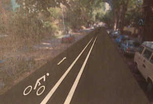
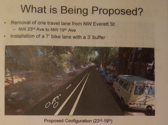
According to PBOT’s presentation shared at that meeting, the current plan is to reconfigure the lanes on NW Everett between 23rd and 19th (an area that has just been repaved, which makes new lane striping much cheaper). In that section, they’ll turn one of the two existing standard lanes into a 10-foot wide bicycle-only lane (seven-foot riding lane with a three-foot buffer) adjacent to an on-street auto parking lane…
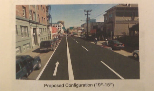
From 19th to 15th, PBOT will put keep the two standard lanes and put the existing right-side bike lane on the left side of the street. The new bike lane will be seven-feet wide (it won’t have a buffer) and it will be adjacent to an on-street auto parking lane. (PBOT will remove the existing bike box at 16th.)
Between 16th and 15th (over I-405), PBOT has designed a mixed zone where people on bikes and cars will share the left-turn lane onto 15th. To facilitate the transition from bike-only lane to shared-lane, PBOT will install green markings followed by sharrows…
An alternate view via the official PBOT plan drawing…
An added bonus of having bicycle traffic on the left side of the street is that it makes for an easier connection to NW Flanders, a street PBOT still hopes to make into a bicycle boulevard (despite the failed attempt to install a bicycling/walking-only bridge on Flanders over I-405 back in May 2008).
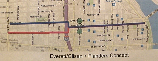
East of 15th, there is no more dedicated cycling space on Everett. This is by design, as another aspect of this proposal for Everett is to do a similar treatment on Glisan, and making both streets funnel into Flanders. Check out the “Everett/Glisan + Flanders Concept” PBOT shared with the neighborhood…
Jonathan Winslow is co-chair of the NWDA’s Transportation Committee. He said they supported the new design. “I wanted to see a cycle track arrangement,” he shared with us via email after the meeting, “but there was pushback over loss of parking and more legitimately over poor visibility of bikes at many driveway crossings.”
PBOT expects these changes to Everett to have several key impacts: better bicycling connectivity from NW 23rd over I-405; safer crossings of Everett; a reduction in speeds and collisions; and longer wait times coupled with slightly increased auto congestion at signalized intersections. The new configuration also comes with the loss of up to four auto parking spaces on Everett west of 18th.
Work on the project is set to start any day now. Questions and feedback about these changes can be directed to PBOT Project Manager Andrew Sullivan at (503) 823-5234 or andrew.sullivan@portlandoregon.gov.
— For more background, read our story about the safety concerns that prompted this project.


")
Thanks for reading.
BikePortland has served this community with independent community journalism since 2005. We rely on subscriptions from readers like you to survive. Your financial support is vital in keeping this valuable resource alive and well.
Please subscribe today to strengthen and expand our work.
Great news. I was wondering why the restriping of the newly paved portion of NW Everett was in slo-go mode. This will make my return trip from Salt & Straw on NW 23rd that much easier.
I wish I understood the appeal of waiting in line for the privilege of overpaying for mediocre ice cream.
Two things about Americans you might not know:
1. Americans HATE inconvenience.
2. Americans LOVE comfort food.
When these two meet up amazing things happen.
Er.. what’s convenient about waiting in line for 30 minutes?
that bike box was one of the worst in portland. i’m very glad to see that it’s going to be removed. overall, it looks like an incremental improvement of a downtown gap.
i see cars cutting cyclists off at other mixing zones far too often. maybe a flashing yield for bikes sign would help with this.
Wow, this looks great. I would use this route everyday instead of wiggling my way down to Overton to cross the Broadway to get to NoPo. Makes the opposite commute nice to when I visit NW.
“On your left.”
Ha! That intersection (16th & Everett) was the site of my very first right hook, less than a month after first moving to Portland. Ah, the memories.
This is long overdue. I’ve been riding through 16th/Everett for decades and started taking the lane there long ago. I think the bike box made it even skeezier for some reason.
In fact it was commuting along Everett that probably hardened my ability to take the lane and mix with cars, it’s so easy to move their speed or faster here. So the Flanders plan would have to come with some changes to stop signs and signals to make it enticing to eastbound bikes.
wouldn’t it be cool if the entire Pearl (and maybe downtown too) had the Woonerfish-type mode mixing you see e.g. along 13th ave, everyone just slow down and chill out a little.
If you’re trying to get anywhere in a hurry, Flanders is a poor substitute. They are not going to turn (or remove) stop signs in a dense downtown area. The best you can hope for are new signals at 14th, Broadway, and Naito.
Or just take the full lane on Everett after 16th and continue on your speed-of-traffic way.
That’s why I said it’s a “poor substitute”. I take the lane on Everett and Glisan now, but many riders are not willing to do this and would prefer a calmer route at the expense of speed.
I ride Glisan from 4th to 14th going to work every day. I will never move to Flanders unless they do something about all the stop signs. How can anyone in PBOT think that putting bicyclists on streets that have a stop sign every block is good? Not only that, you have to cross some very busy streets with no help. If they are going to do this then they need to turn most of the stop signs and put up lights at 14th, 11th, 10th, and Broadway so that it is possible. I don’t see that happening. I agree with the changes from 23th through 16th but after than I am going to stay on Everett and I am going to continue to take the lane on Glisan.
In such a dense area, pedestrian safety takes priority over bicycle convenience. People forget that turning the stop signs means that inevitably drivers catch on and start taking advantage unless you put up diverters everywhere.
No stop signs are going to be turned on Flanders. Stay on Everett and Glisan.
Not if it was combined with lots of diversion…every other block at least. That, however, would require PBOT to invest in a green wave of bike lights and intersection redesigns.
Used that bike lane once before realizing riding the left hand lane was the much wiser way to go, this was an example of adding a bike lane and box that made things more dangerous. Anyone can keep up with car speed on that downhill.
Fantastic. Now continue this to the waterfront.
I don’t commute down Everett regularly now, but I did from 2000-2003, IIRC going back to before the bike box was installed. That was always a really awful intersection for right hooks. Fortunately I never got hit, but it really taught me more about when to watch for them, and taught me about how drivers behave when they’re near freeway on and off ramps. Glad to see this change.
Like Reza I have some concern about Flanders becoming the preferred bike route, unless they’re going to do something about the stop signs. I don’t exactly find the trip down Everett from 14th and Broadway to be pleasant, but it IS fast.
If the new striping on Everett goes in and directs more traffic onto Flanders, would there be a way to connect onto the Waterfront Park & lower deck of the Steel bridge?
Talk to UP and ODOT about that.
Uncle Pete doesn’t care what you think.
A world-class solution would be to construct a ped/bike flyover of Naito. Heading east on Flanders, you would cross 1st Ave and the Naito ramp, and then gain about 10ft to clear Naito itself. The bridge would turn north and then dive down under the Steel Bridge northbound ramp to meet the waterfront path just west of the steel bridge path. This, coupled with a counter-flow eastbound bike lane on Flanders (remove the south side curb parking for two blocks) between 3rd and 1st would create an amazing east/west route downtown.
Chris,
I like the idea of a flyover, and the reason I ask specifically is because I have been working on getting improvements on N Interstate south of the ramp that goes to the Broadway bridge (http://bikeportland.org/2014/01/10/citizen-activists-work-to-fix-narrow-bike-lanes-on-interstate-ave-99687) which is a key feeder to Steel Bridge traffic into downtown and this would become a more in demand route if there were a better connection from the Steel Bridge into NW.
PBOT better hurry and just do the work, not talk too much about it or the businesses might band together right near there and block any improvements for bike design.
Not to mention that the process never felt adequately inclusive to the hippies and artists displaced by the gentrification of NW when our families were forced out by developers and all the new businesses looking to make a buck from the yuppies.
Why is there no consistency with how biking is planned for this city? Williams/Vancouver is completely different than Moody. Moody has you go across several streetcar tracks on the same side of the street one way, and change course coming the other. The signing for people on moody is hard to see under many conditions (which probably scares the crap out of any pedestrians on that side of the street.)
This city is such an inconsistent mess with its bike planning. I hate to say it, but the Feds maybe need to smack some rules down on PBOT/ODOT here so we don’t stick out like a sore thumb?
Try an imagine what someone new to Portland would think of all our various hacks with bike infrastructure!
We’re still in that experimentation stage.
Sometimes it sucks to be a guinea pig, but its better than the alternative of doing nothing, or not finding out what works best.
Street car is desired on Vancouver/Williams as well.
Maybe different solutions are used in different places because they don’t operate the same, or are different ages – south waterfront is brand new, north portland is not.
is a bike lane also being installed on Glisan between 15 and 23rd? it looks like that from the graphics, but you didn’t mention it. that would be very needed. even more so than everett in my opinion. getting through the NW is a pain in the ass, this’ll help a little, but it’ll still be slow.
I agree. The Everett changes will be nice. I ride this entire stretch in the morning to work. Many of those intersections from 16-19th especially get compounded with the distraction of sun glare at certain times of the year. I’ve never found Everett to be that bad as it’s slightly down hill and even a casual pace keeps pace with traffic. The intersection at 16 can be tricky if you don’t ride anticipating a right hook.
I also hope they make the changes to glisan soon as well.
all they really needed to do is remove the stormwater swale on the SW corner of NW Everett at 16th and put a dedicated right turn only lane to the right of the bike lane, just like at SE Madison and Grand.
I think that left lane merge between 16th and 14th is going to be just as problematic as the current right hook problem at Everett and 16th.
Just like I said in the previous article about Everett, the left-side bike lane was a fait accompli.
At least this followup (re-)acknowledges that the real fix is a continuous Flanders greenway with a bridge over I405—not climate-controlled, cancer-curing cycle track.
This is cool, but Flanders? Don’t ever think I’ve thought about taking that, though, and will probably just continue down Everett on the left side now I guess.
The Everett bike box has worked, and would work, if drivers didn’t treat it as a car box.
this was one of the bike boxes that pbot found to be associated with increased conflict.
What I see in this design is a complete caving to automobile dominance.
No cycletrack because that would mean people couldn’t store their cars on the public right of way. So instead we get another door zone bike lane.
And no bike box.
Then we get funneled into a “mixed zone,” before being removed to the next street over.
Yay for going backwards.
Did you even read the post? This bicycle lane is TEN feet wide (7′ bike lane + 3′ buffer). Are you saying you can’t avoid opening doors with this generous clearance? And they’re passenger doors too, so the risk of encountering an opening door is lower than a right-hand lane. In fact, the bigger concern is that the lane is so wide that drivers will ignore the bike lane signage and markings and continue to drive on it with impunity.
And there’s no reason you can’t have a cycle track that preserves on-street parking. After all, that’s pretty much what parts of SW Broadway and parts of NE Multnomah have currently.
My mistake, I see you were talking about the section east of 19th. If you feel uncomfortable riding that, you’re welcome to take the left lane as many people here do already.
You should run for office on that platform.
I will continue to take whichever lane is appropriate at the time and continue down the hill on Everett, although I do like Flanders as a connection to 3rd east of NW B’way…
Just the other day we were depressed & whining about our infrastructure momentum going all to hell, then this comes out. Thanks, PBOT.
I wonder if a chunk of the old Sellwood Bridge could be turned into a Flanders Bike/Ped bridge, once the new one is finished. (The 2008 plan was to use a piece of an old bridge, wasn’t it?) Take a length of the steel structure (without the current deck) and put a new deck on it. If we did that, maybe we could toll it for bikes from Clackamas county.
The plan was, indeed, to reuse the old Sauvie Island Bridge.
Terrible terrible idea. I was stuck behind 10 blocks of one lane traffic today… on a Sunday. Imagine what rush hour is going to be like when that right lane was already backed up. They’ve killed through traffic through NW. Why not put the lane through one of the side streets? Now, cars have to go through Burnside, which is already bad (imagine what it will be like now) or go all the way north to First/Naito. I’m just not even imagining why this was a good plan for moving people. If they want to ban cars in NW, just ban then and make a transit in the area free.