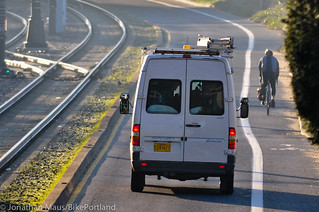
on surface streets (like N. Interstate shown here)
is unacceptable.
(Photo © J. Maus/BikePortland)
The City of Portland Parks & Recreation bureau continues to come under fire for their work on the North Portland Greenway Trail project. PP&R is in the process of designing the route of the paved path that will connect Kelley Point Park north of St. Johns to the Eastbank Esplanade in the central city. However, as we reported last month, many people are disappointed by the chosen alignment in the trail’s southern portion. Instead of staying along the Willamette River and creating a path away from auto traffic, PP&R has focused their efforts on what they consider a “near-term buildable” route on sections of busy, and sometimes narrow surface streets. The route, critics say, fails to live up to the vision and promise of the trail.
“It has been a waste of funds to study Greeley as an alignment. The plan is to be a North Portland Willamette Greenway Trail. A trail located along Greeley is not a Willamette Greenway trail.”
— letter signed by npGreenway core team
Yesterday, npGreenway, the non-profit group that fought and pushed for this project in the first place, sent a highly critical letter to PP&R staff and the project advisory committee. “At this point,” wrote npGreenway’s core team of volunteers, “we are less than pleased with the conclusions.”
Central to npGreenway’s concerns are that PP&R (as their name would suggest) is failing to grasp that the trail is far more than just a recreational facility. To that point, the manager of the project for PP&R is Emily Roth, whose official title is Natural Resources Planner. (This underscores an ongoing issue of PP&R’s management of multi-use paths that play a crucial role in our non-motorized transportation network.)
Here’s more from the letter (emphases mine):
“Our feeling is that Parks staff sees this project as a mostly recreational trail and fail to grasp the importance of it as a daily transportation trail as well as recreational. Their choices of alignment focus on the easiest to achieve possibilities, regardless of the fact they are not close to the best choices for a trail that meets both uses. The trail does not connect to the Esplanade. It does not provide safe passage for the first two segments one would encounter leaving the Esplanade, heading for Kelly Point. It does not provide a useable trail, rather relies on narrow, non conforming on-street facilities shared with high volume motor traffic and light rail to Greeley where you cross to another high volume motorway in a separated path to a tenuous crossing at N Going to connect to another separated path alongside N Going to Swan Island where you may need to cross high volume traffic for Swan Island or continue down Basin to Waud Bluff. If this seems confusing and difficult, remember it also includes steep grades and dangerous intersections. These major failings make the trail non useable for North Portland commuters.
In short, npGreenway feels the effort so far has been substandard on the part of Parks staff. The 2030 Bicycle Master Plan (BMP), adopted by Council in 2010 states goals of increasing ridership substantially in the coming years. The BMP 2030 lists obstacles to achieving that goal, and the primary concern most riders and walkers have is safety. Parks efforts do nothing to alleviate that sense of danger in the Segments 4 and 5. In truth, we doubt any amount of money and effort can make the Greeley segment useable. Its only purpose serves to do a ‘checkmark’ for that segment, to leave it to future staff to untangle. The Cement Road segment is the only possible alignment and efforts to make Greeley an option are dishonest.“
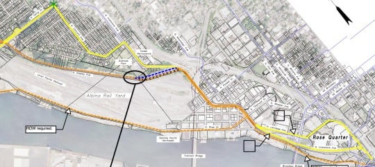
For some context, below is the current alignment proposal for section five (note the “ROW required”, which is the route npGreenway wants, versus the yellow “near-term buildable” line on surface streets):
Also in the letter, npGreenway calls for a minimum width of 14-feet based on anticipated demand and the ability to separate walking and biking.
As for the controversial Greeley segment — which PP&R is using instead of the much more desirable “cement road” — npGreenway stated that they “flat out oppose” it. “It has been a waste of funds to study Greeley as an alignment. The plan is to be a North Portland Willamette Greenway Trail. A trail located along Greeley is not a Willamette Greenway trail.”
It’s worth noting that while Greeley is a busy road with fast-moving cars and trucks, the current plans call for a new separated cycletrack. See the cross-section below:

For their part, PP&R says they will “continue to seek an easement across Albina Yard (another name for the cement road)” but they are clearly loathe to upset the owners of the cement road, Union Pacific Railroad. UPRR has clearly stated they aren’t interested in selling or allowing public access; but advocates feel it puts the City in a much weaker future negotiating position if they fail to at least commit to pushing strongly for it. And putting the preferred alignment up on Greeley could make it harder to muster the political and public momentum it will take to push for the cement road. “Things change,” writes npGreenway, “Without a preferred alignment on the Cement Road, the onus of planning puts the Greeley Ave option as the preferred choice when it is anything but that.”
Signatories on the letter include the Co-chairs of the city’s planning advisory committee, the executive director of the Swan Island Business Association, a representative for Daimler Trucks North America, and others.
The current project from PP&R is to complete 10% preliminary engineering plans, garner community support for the alignment, and prioritize which segments should be built first. The draft plan is due mid-February.
If you missed the final open house, the City is still accepting comments. They’ve published an online comment form and the deadline for submissions is tomorrow (1/23). View each of the five segments and learn more about the project on the official project website.


Thanks for reading.
BikePortland has served this community with independent community journalism since 2005. We rely on subscriptions from readers like you to survive. Your financial support is vital in keeping this valuable resource alive and well.
Please subscribe today to strengthen and expand our work.
I filled out the comment form but after submitting, the resulting page was empty and didn’t have any success or failure message. Is it broken? Is our feedback being received?
Uncle Pete is tough to deal with. I can understand why PBOT is avoiding the issue, but the trail really needs to go along the river to be effective. I thought this was supposed to be a world-class biking city?
Effective at what?
Show of hands: How many of us actually work, shop, live along the banks of the Willamette River? This path will serve very few of us in an actual utilitarian capacity.
I’d still love to see this Greenway happen, but the fact is that as soon as I turn off the riverpath and head toward my actual destination, I need a bike lane that isn’t there. If I’m headed to say, any destination along Grand, suddenly my safety is threatened.
But at least there’s on-street parking. Thank God we have that. I foolishly hoped there would eventually be some sort of bike lane along the arterial roads I need in order to get to places I need to get to. No, no, that’s okay. I’ll just merge with 40mph traffic for this last block so that you can leave 2,000lbs of your private property unattended in a public space. That makes far more sense.
This Greenway is a feel-good distraction from what Portland Commuters really need – a bike lane on every street busy enough to have a center line. Safe public access to EVERY STREET, regardless of the mode of transportation.
Sorry, but we’re putting the cart before the horse, all the way.
When I review these plans, I imagine a parent with 2 kids, one in a stroller, one on a bike (6 or 7 years old), out for a jog with their dog. The “North Portland Greenway Trail” on the map shows a continuation along the river from the Eastbank Esplanade, but at the top of the ramp (heading north) this family is routed along discontinuous sidewalks, across very busy intersections, etc. This alignment does not work from a recreational perspective: it is unnavigable and very unsafe. It also does not work from a bike commuting/transportation standpoint as it remains unsafe, and is indirect.
I was pretty disappointed at the last openhouse. The current plan to is to show a “near-term buildable” solution that they optimistically think could be built in 20 years. This plan doesn’t address getting from the Esplanade to Swan Island, and proposes to use existing (unsafe) infrastructure along Interstate with a new separated trail along Greely with some very awkward and unsafe movements at Going. I believe that if we are expecting this to take 20 years, we should put a stronger foot forward so we have something worth fighting for and investing in! The northernmost sections seem reasonable (from Kelly Point to U of P) however, the option for getting from Swan Island to the Esplanade is inadequate. 2 areas stand out for me as being particularly unsafe, unpleasant and unworthy of investing in:
1. The off-street, separated trail along the east side of Greeley that will have to be constructed with walls, and basically be a 12′ wide, 2-way trail adjacent to Greeley (unpleasant) that will then tie-in to the existing infrastructure on Interstate (5′ bike paths with 2.5′ pinch points, sidewalks on one side of the street, etc.). This does not seem like money well-spent, and this plan does not seem to consider the recreational side of things.
2. As I mentioned earlier, the existing “infrastructure” along Interstate is being used for the “near term buildable” (20 years!) through the Rose Quarter and connecting to the Esplanade, a woefully inadequate connection. For some reason, this plan does not show a path along the Thunderbird property with a connection to the Esplanade UNDER the Steel Bridge. In 20 years, there should be the will and capital for this.
This plan represents an opportunity (hopefully not a missed opportunity!) to provide a vision for the Rose Quarter redevelopment that is being planned now!
I believe that there are a couple of (expensive, visionary) options worth advocating for, and worth including in the plan:
1. Esplanade to Thunderbird property: a path suspended from the bridge abutment (over the railroad service drive) from the Esplanade under the Steel Bridge to the Thunderbird Property. This could connect to the Esplanade at existing ramp landing.
2. Tillamook to Thunderbird Property: The Larrabee ramp could be repurposed as civic recreation connector and destination. The existing ramp could become a super wide, elevated garden park with separate biking and walking paths incorporated with hang out spots to overlook the city and west hills: think Highline with a 2-way bike path! This would provide a super strong connection to the river for the Rose Quarter, the Lloyd District, and the Pearl District via the Broadway Bridge. A new elevated path would connect from the ramp, down under the Broadway Bridge (river side) and connect to the Thunderbird property along the top of the bank. Cars and trucks travelling south on Interstate Ave would simply drive a bit further south down Interstate Ave and use the existing left turn lane/signal to access Broadway.
3. Getting to Swan Island: The Cement Road is the obvious choice, and Parks recognizes this, but their hands are tied because of ownership; understandable. However, From Tillamook, a path could be developed from Tillamook to the end of N. River St, then turn east and follow the alignment of the Fremont Bridge back to Greeley, but stay on the west side. This could keep users below the road, closer to the river, and create a route under Going. Once on the north side of Going, the path could split to acknowledge Swan Island as a destination/peninsula. One path could head west to Basin Ave and the Waud Bluff connection for riders who can handle a large stairway to cross the tracks. This path could also continue to the river near the Port Building and the existing path and beaches. See number 4 for the second route suggestion.
4. Getting to the University of Portland: From the north side of N. Going St, the path could continue along the base of the bluffs, above the railroad tracks. Some soft walking and jogging paths could run through the wooded area across from Adidas. The path could then slowly climb the hill to join with N Willamette near N. Ainsworth (through what is known as Fennel Park or the Dog Bowl). I would further recommend that Willamette from Rosa Parks to U of P is changed to local car traffic only, or possibly 1 lane, one-way traffic headed north with parking only on the east side,. The west half of the road could then be a shared bike/pedestrian space. The NP Greenway path could head down the existing road grade at N Portsmouth or N Van Houten Pl. and connect with the recommended alignment.
5. Connections from this path to Overlook Park, Mocks Crest, Madrona Park and Fennel Park/Dog Bowl and maybe a couple of other spots on the bluff for people to enjoy the view of the river and access recreational amenities.
I think we need to let Parks how disappointing this lack of vision is, and encourage them and city leaders to push hard to finalize an appropriate, and visionary trail alignment to work toward for the next 20 years!
I am a pretty confidence cyclist, I have commuted year round for 5 years and used Interstate a lot during that time and it still makes me uncomfortable being passed by 18 wheelers on the narrow section between the Bway bridge exit and the RG. They cannot expect to increase traffic if that section of the road is required. Anyone who is not an extremely confident cyclist will not use it. Period.
Interstate is too narrow! REGARDLESS of riding skills.
I recall some nasty choke points there.
the bike lane and sidewalk narrows severely with no warning!
I’m comfortable on Interstate, I enjoy riding hills, and it’s the most direct route for me. And whenever possible, I take Williams, because Interstate sucks.
Whatever the plan, Going is no sort of “connector” route without major changes. A single sketchy sidewalk, a race with the triple-trailers jake-braking their way down toward Swan Island, or or tangling with harried commuters trying to get on the freeway back home: what a choice!
I’ll add that much of the ideal route is a quarter of a mile out and 100 feet below any homes. Combine this with being a PP&R project and it sounds very much like a recreational trail to me. It sounds like a nice alternative route to the West Hills via SJB, but for Kenton, St. Johns, et al. I’d still use Denver/Rosa Parks/Willamette.
It seems like there’s a shortage of good ideas for this greenway all around.
Can’t get right of way on the Cement road? Run it right along the river, just like the Esplanade.
DENIED: docks/waterway access rights for rail & industry here.
How about: a raised MUP over the railyard making key widenings at historical and tourist viewpoints?
Union Pacific could call their concession “The Historic Albina Rail Yard Trail”. This would have the benefit of providing bike and pedestrian access out of the way of critical commerce while providing UP with good PR as long standing member of the business community and a pivotal part of Portland’s history.
Basically a long linear history museum.
Justz spit ballin’ ere.
In the absence of permitted access to Cement Rd/Albina Yard:
(cost of some long, expensive raised MUP overpass to connect over private land) VERSUS (cost of wrongful injury and death lawsuits later when it be shown that the designers knew the problem existed and ignored calls to stop)
After the Space Shuttle Challenger explosion due to O-ring failure on the solid rocket boosters there was a great rush to blame the outside company that made the SRBs and sue them out of existence.
The company was able to show a solid paper trail of foreknowledge on NASA’s part of the cold problem and repeated warnings right before the ill fated launch that this type of failure was likely in those conditions.
Much like PP&R in this situation, NASA’S chose to ignore valid safety concerns in misguided attempt to fold to political pressure or the desire to check off some box saying “We’ve achieved something!”
Perhaps PP&R feels that project completion is more important than project quality. From a political standpoint I can see where more projects completed look better to the uninformed public than fewer high quality projects.
I propose terrifying them with the fear of costly liability.
Just a thought.
Rather than yell and scream at the city (who righty feel thier hands are tied and who seem to agree that this is the best route)why not letter bomb Union Pacific with complaints and arguements for access to the road?
A few minutes with an online petition or form letter from a few thousand cyclists and pedistrians might help….might not either.
I’d do it myself but I’m not very elequent or that good with web stuff to pull it off.
The city, with the support of many, applied and received nearly a half million dollars to do the study, with the expectation of it also accomplishing 10% of the pre-engineering to push the project into the ‘apply for funding’ realm.
Parks staff has not accomplished all of the goals, and the plan they submit is totally out of sync with the 2030 Bicycle Master Plan.
Its not too late to rethink things.
As for UP railroad.. they can be monolithic in their thinking,but they too want things.. like Transportation dollars, rights of ways in other parts of Portland or Oregon.. there are levers that can be applied.
But yelling and screaming at the city is what is rightly needed here.
The city’s hands might be tied as to unilateral use of the Cement Rd trail alignment without Union Pacific’s permission. This much is a given; we will only get what Union Pacific feels like giving us.
What demands the exasperated screaming and profanity is the sense that PP&R and the city seem to be locked in to spending any funding on this dangerous, inappropriate and costly Greely and Interstate route.
THERE IS ANOTHER OPTION!
DON’T DO IT!
Don’t build anything or set in stone a permanent route.
Just say we’re holding out for better options, more funding, more community involvement, whatever.
Just don’t commit our hard earned tax dollars on a solution NO ONE WANTS just because it seems like the only thing that fits the plan as it is written now.
There is still time: this can still be stopped. Plans can be re-written.
We are not locked in to doing the worst possible thing no matter what siloed bureaucratic thinkers tells us.
Well said! There is already sketchy infrastructure on Greeley and Interstate, I want the city to show a preferred alignment, with a preferred connection to the esplanade, and give us rough (10% level) idea of the engineering and cost to build it! The political maneuvering and fundraising can start from there. Compromises may happen along the way, but this plan is so severely compromised, it seems like a non-starter!
At the openhouse, it was stated in one breath that “Portland Parks doesn’t create trails that lead to or end in unsafe conditions” and in the next “well, Interstate was created as part of the Light rail and got some excemptions to have substandard bike and pedestrian facilities put in (due to space and financial constraints)”. All the while they are standing in front of plans that send bikes, peds, strollers, wheelchairs, down Interstate, across the “spillway” of the east side of the Steel Bridge, along Greeley and Going…I am not sure what the PPR definition of unsafe is, but it is too sketchy for me!
The orange line is exciting, the yellow… why bother?
20 years is “near-term” when it comes to buildable? Are they hoping be retired far away from here before it gets built, so they can avoid blame? And, with PP&R being perpetually on the budget chopping-block, how much would anyone like to bet that this program is first in line to take the cuts? (Hey, it’s only a “recreational” trail! It won’t even be built for 15 years; what’s the hurry? Maybe next budget cycle we’ll have money for it…). If we are the cream of biking cities in America with THIS sort of project, we’re hosed…
Apologies if I missed this in earlier discussions, but why isn’t the possibility of acquiring the preferred route easement via eminent domain mentioned?
You can’t eminent domain railroad companies; they seem to exist outside normal laws.
I’m not certain the US military could get them to capitulate to their demands without a Congress signed act of war.
The question that needs to be asked is this:
“Is completing this trail system so important that we must include a segment this dangerous and unwanted by the public?”
Or more generally:
“Is the completion of this or any other project any more important than the safety of those it serves?”
I just feel that the completion of this project segment is a notch on some politico’s belt to say to the cycling community “I care”.
I have been to most of the open houses, and other than segment five, I actually think the group has done a decent job of developing the first four segments with what they have to work with, with a few exceptions.
EVERYONE HATES segment five, including the Park’s department. All it is, is a cycle track on Greeley to make that portion of the commute more comfortable, it is NOT a trail and everyone knows it. It would however be nice to have for those who do commute down Greely, but not with funding for a river front trail. That is why it is an independent unit and funding would be applied for independently so as not to tank the other sections. It is a good idea that needs to be added to the “would be nice ” pile in the bike master plan, but as a commuter upgrade and not even be associated with the word “trail.”
Cement Road is still the only preferred option.
For those who suggest the city condemn the property or construct a path on the river front itself, these are not options because the railroad has federal protections that the city can not override, it has not the power. That would have to be taken up with congress. Of course, when the railroad wants something from us…..
The group has stopped any development or study further in to the Rose quarter specifically because of the possibilities of the Thunderbird Hotel site and the possibility of an East side Esplanade connection, but this makes no sense to plan and waste money on until if and when the Rose Quarter expansion is funded and built. This will be a huge project that will redesign the area so it makes no sense to spend research money to develop a trail plan when the area will completely change. Maybe we can find some way to integrate the Eastside Esplanade connection into the Rose quarter plan?
“Going to the River,” as in the expanded path next to Going which will hook up with the Basin cycle-track is being built and expanded as we speak. I saw the sections of sidewalk getting chopped up yesterday actually. It SHOULD be pretty nice and accessible, just not from Greely. Access to Swan Island to the trail to be comfortable would be gained from the Going overpass at the Concord neighborhood Greenway.
The Basin cycle-track has also been improved and I think they did a good job with it considering the ROW. The cycle track will be physically separated not only from the traffic on Basin but also from pedestrians since they will also have a sidewalk on the north side of the street. I think they have even saved the majestic trees.
The group also recognizes that 14 foot is the preferred width. The biggest problem with this is the bend around Willamette Bluff. In reality, this is the first section that is actually a river front path, everything else to this point coming from the south is all on street cycle-track type improvements….good for commuters and needs to be done, but it is NOT a trail.
They are arguing that the path may need to be narrow around the bluff because of width restrictions. The path on the waterfront has to be 20 feet away form the center of the railroad tracks, but they also want to keep it out from over the water because of the increased environmental review, so they want to SQUEEZE it into the space provided meaning it may only be ten feet wide. This my be fine if the money was available NOW and we could built it immediately, but if their definition of “near term build able” is 20 YEARS, then worrying about the extra a cost of “environmental reviews’ because you want to hang over the river five feet more than allowed by the coast guard is just plan stupidity. They need to design and plan for the wider 14 foot path (preferably with an expanded viewpoint at the bend over the river) and if that entails extra environmental review because of river issues than so be it, this is going the be the best part of the river walkway and we need it to be nice and wide.
Oh yes, whomever decided that the Waud Bluff trail needed a stairwell instead of a ramp made an idiotic decision, but there it is….way too late now.
20 years for a river front path? China is building 10,000 miles of High Speed Rail in ten years and we can not build a ten mile bike path in 20, come on….what does THAT say for this nation’s priorities…..
“The group has stopped any development or study further in to the Rose quarter specifically because of the possibilities of the Thunderbird Hotel site and the possibility of an East side Esplanade connection, but this makes no sense to plan and waste money on until if and when the Rose Quarter expansion is funded and built. This will be a huge project that will redesign the area so it makes no sense to spend research money to develop a trail plan when the area will completely change. Maybe we can find some way to integrate the Eastside Esplanade connection into the Rose quarter plan?”
I think this is the exact place to show a connection to teh alignment along with conceptual engineering and cost estimate in order to inform the Rose Quarter planning. This will absolutely not be the priority or goal of the Rose Quarter plan, but they may respond to and include this concept IF it exists as a widely supported city plan. The Rose Quarter plan will want to get people to the river, but it will NOT be planning regional recreational and transportation routes, that is just outside its scope. For future plans and projects to include this trail and connection, it needs to exist, it NEEDS to be shown, and Parks is completely neglecting its duty to simply leave this for someone else to figure out!
TerryD
what do you think of this option (below) to what is being proposed at Greeley (Segment 3 and 4)? I thik it could be a valuable route and neighborhood connector, even when the Cement Road becomes available, but could be built nearly as easily as the “near-term build-able” but would safer, more pleasant and accessible! Check it out:
From Tillamook, a path could be developed from Tillamook to the end of N. River St, Then turn east and follow the alignment of the Fremont Bridge back to Greeley, but stay on the west side. This could keep users below the road, closer to the river, and create a route under Going, along the bluffs, into the wooded area across from Adidas, then slowly climbing the hill to join with N Willamette near N. Ainsworth. I would further recommend that Willamette from Rosa Parks to U of P is changed to local car traffic only, or possibly 1 lane, one-way traffic headed north with parking only on the east side,. The west half of the road could then be a shared bike/ped space. The bike path could head down the existing road grade at N Portsmouth or N Van Houten Pl. I think a secondary bike route along the N side of Going on Swan Island to Basin Ave and the existing River paths would also be an important part of this. Eventually the turn at the end of River Road would continue down the Cement Rd. Also, there could be a route to connect with the “bluff-side” of the Waud Bluff Trail to connect to that trail, for a neighborhood connection, or to continue along the river once the cantilevered section is built.
“Oh yes, whomever decided that the Waud Bluff trail needed a stairwell instead of a ramp made an idiotic decision, but there it is….way too late now.”
I am also appalled by the construction of a staircase as bike infrastructure. Though inexcusably short-sighted, I can understand how it got built because it was lobbied for so strongly by the Swan Island TMA as a safe connection for employees. However, now that it is there, I think it is inexcusable for Parks to show this as THE ALIGNMENT for a major civic trail with absolutely recommendations for modifications. Can someone please tell me how this is even legal considering the Americans with Disabilities Act?
a multi-use path isn’t even close to the same thing as a separated cycle-track…
it looks like a separated multi-use path to me… I think the proper term is shared-use footway… better than a bike lane, but it’s not a cycle-track…
I hope people are filling out the PPR comment form, and suggesting that friends fill it out, too. They haven’t been been doing a very good job of listening, but I think enough comments may require some action.
http://www.portlandoregon.gov/parks/60906
I filled out the form, and in the comment section, I asked the planners if they felt comfortable allowing their own children to ride the whole route.
Looking forward to the day when transportation projects, like this one, belong to PBOT.
Ah, man. Thanks for sticking up for a true trail, NPGreenway.
Putting a “trail” on a street isn’t a trail!
The city might just as well have said that the river itself is a segment!
“And at this point in the trail, jump in to the river and swim to the Esplanade”.
I’ll email them presently, hope that helps.
In recent discussions with the city, they urged me to use their recent buzzword “EQUITY” in order to be heard.
I duly submitted my comments, pointing out that this crappy “trail” further points out the deeply divided, and inequitable nature of spending on infrastructure in Portland. The core of the city gets world class projects, far east and NoPo get junk.
If you can’t make it good, don’t build it until you can!
Also, I am trying hard not to be cynical about the fact that the comment form link from the project page doesn’t go to a comment form. Thanks Jonathan for providing that.
I’m maybe not the most up to date person on the project, but as a North Portland home-owner hoped they’d listen. I worded it kind of strongly on purpose.
“Overall I am delighted this trail is being pushed forward, but I had to mark neutral overall because segment 5 seems so unfortunate. The trail’s proposed alignment in Segment 5 along Greeley seems passable at best. It’s better than nothing. However obtaining the Right of Way and running the trail along the river seems like a vastly better and long-sighted solution. Greeley is loud and dirty to cyclists and unsafe for pedestrians as it stands now. Physical separation from traffic would be an improvement but I would much prefer the use of the river bank near the train yard would tie the experience to spring water trail and the esplanade and become an iconic use of city space by putting people first.
“Segment 4 seems less than ideal as well. On bike I see this as very out of the way and confusing around Channel Ave to Lagoon Ave before finally connecting to Basin Ave. A better solution would be to use Anchor Ave as a protected (physically separated) two-way bike and pedestrian space along one of the side of the street. Anchor Ave is very wide, and potentially doesn’t even need to be two auto lanes. I also believe traffic along Basin Ave is so fast and dominated by very large vehicles that a curb and reflectors would greatly help a more people feel safe along it.
“In regards to the order of the segments being constructed the proposed arrangement seems the most politically easy but backwards to how the majority people would actually use the trail. Getting to and from the city center seems like it should be the highest priority. It seems like a more immediately effective use of resources to let people continue using the very popular East Bank Esplanade northward. To start the project by creating trails from a place where very few people are or ride (segment 1 from kelly point to St Johns) will hardly get used at all if it does not connect people of the community. Plus if for whatever reason funding was to be lost or delayed it would be much better to have the southern segments finished and usable rather than the northern segments. The building of segments should be reversed, starting from the Esplanade and moving North towards Kelly Point.
“Thank you for your time and dedication to this project.”