


(Photo © J. Maus/BikePortland)
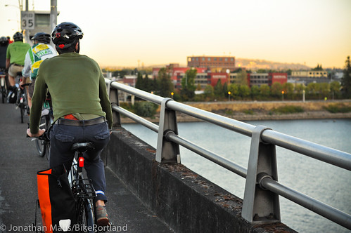
Last night was the annual Portland Bicycle Advisory Committee (BAC) facilities tour. The BAC is a volunteer group of citizens who advise PBOT on how transportation policies and projects impact bicycling. Each year, they leave their usual City Hall meeting room to get an up-close look at bike infrastructure. Last year we explored east Portland, and this year the focus was on downtown and the inner eastside — a part of town the city commonly refers to as the central city.
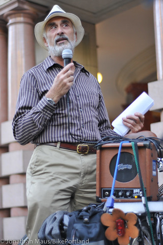
PBOT Bike Coordinator Roger Geller led the ride, and would speak from a mic attached to a small amp he carried on his rear rack. “I never thought we had enough to show off in the central city,” Geller said at the outset, “But we’ve done a lot of work.”
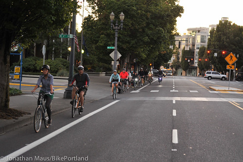
The route (annotated PDF here) took us from City Hall, up to Portland State University, over to the South Waterfront, back north to the Morrison Bridge, along the Esplanade up to the Lloyd District and back through northwest Portland via the Broadway Bridge. We stopped several times along the way to chat about the different bikeways and issues that came up.
Here’s Roger on the mic…
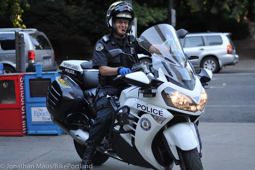
And we even had Portland Police Traffic Division Officer Ty Engstrom follow on his motorcycle! (He would have his bicycle; but he forgot this month’s meeting was a ride)…
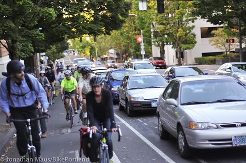
The parking protected bike lane on SW Broadway…
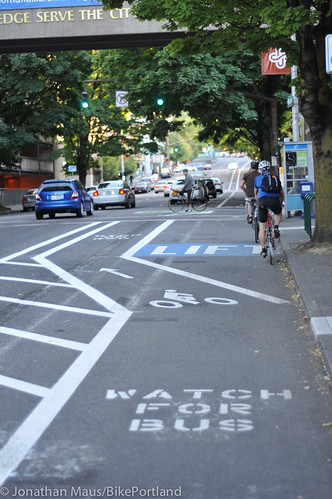
New striping was recently added to allow transit vehicles direct access to the curb…
As we made our way up to the parking-protected bike lane on SW Broadway, Geller explained that there are currently only 2.9 miles of cycle-tracks (a general PBOT term for protected bike lanes) in Portland’s entire bikeway network. In his mind, “Everything else [in the network] should really be updated to provide more positive protection.”
A few minutes later we were rolling on the (relatively) new cycle-track on SW Moody. “If we had a network these,” Geller said, “We’d have 50% ridership in the central city.”
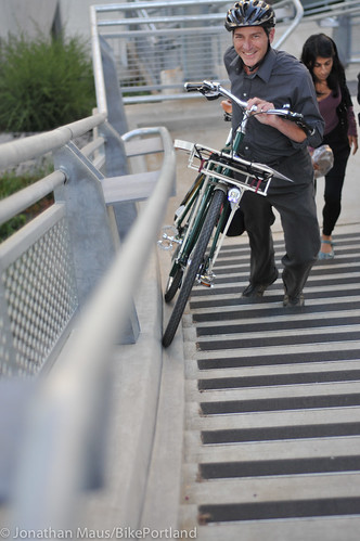
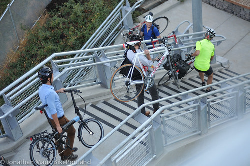
Our fun riding ended at the base of the new Gibbs Street Bridge, as some folks waited for the elevator, while others hoofed their bikes up several flights of stairs.
The new bridge connects the Lair Hill neighborhood to South Waterfront; but the access on the eastern side isn’t ideal. The elevator was recently out-of-order for a few weeks and the wheel gutter on the stairs is sort of a joke. It’s just a few inches wide and it’s difficult for many people to align their wheels on it while pushing up the steep incline. A PBOT staffer on the ride told me they’re considering improving the wheel gutter design, but the project hasn’t been green-lighted yet.
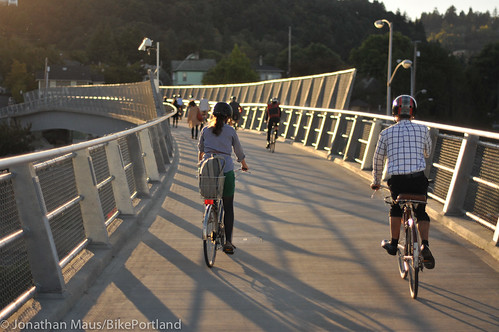
Once you’re up, it’s sublime to roll over the noise and traffic of I-5…
Once over the bridge, we connected to SW Corbett Ave. With the new bridge, folks in the Lair Hill neighborhood are excited to be connected to the south waterfront. Advocate and resident Roger Averbeck said Corbett is a key connection and now all that’s left is to “connect the dots” between it and other projects in the area. Averbeck would like to see Corbett get the bike boulevard treatment with speed bumps and sharrows. As you can see below, it’s got a lot of potential…
On our way back north through Waterfront Park and onto the Morrison Bridge, I asked Geller about the potential for a new bike path that would alleviate crowding on the existing shared facility on the riverfront and would be more pleasant and safer than the bike lanes on Naito Parkway. He didn’t say anything was in the works, but he did mention that the park’s Master Plan (adopted in 2002) calls for a bike path through the middle of the grass (I’ll look into that and post separately).
Before we climbed up onto the Morrison Bridge, the front of the group was nearly taken out by a woman driving a car. She must have been distracted because she plowed right through a red light. She locked up her car’s brakes and skid for several feet, narrowly missing a few of the riders. Whew!
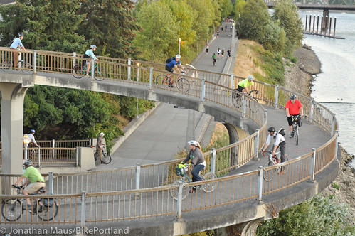
Up onto the Morrison Bridge, we stopped for a while to enjoy the setting sun and then descended to the Esplanade via that neat corkscrew that I always enjoy riding on.
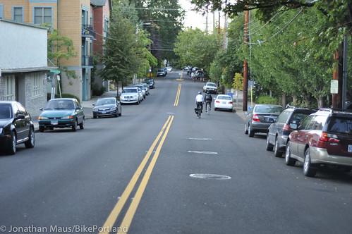
From the Esplanade we rode northeast up to the Lloyd District via NE Multnomah Street, which is slated for a road diet. PBOT plans to change the cross-section from five standard lanes and narrow bike lanes to just three standard lanes and protected bike lanes. That’s a very exciting project that I can’t wait to report on (stay tuned).
Here’s how the street looks today (lots of room to work with)…

We then headed west on Broadway (cheering as we passed the partially closed Wheeler Ave) and into the Pearl District via NW Lovejoy. Noticing the sorry state of the two measly plastic bollards that remain (after PBOT’s failed attempts to keep cars out of the bike lane due to the “track-straddling” phenomenon); I heard a PBOT staffer say that, “Motorists would rather run over plastic cones than drive in the streetcar tracks.”
The good news is that I hear PBOT is still discussing how to make bollards work in this location. Stay tuned.
The other big issue with Lovejoy — after it was decommissioned for the streetcar project — is that now bike traffic is forced over to NW Marshall. PBOT intended to make Marshall a bike boulevard, but it hasn’t worked out that way. “The auto traffic volumes on Marshall are high, and there are a lot of stop signs,” Geller admitted. To help improve it, they plan to but a traffic diverter at NW 10th (and maybe another one at 15th if that doesn’t work), and turning some stop signs is another possibility.
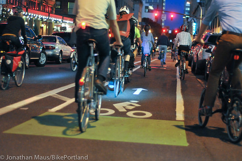
After a brief stop to pay our respects to the Zoobomb Pyle sculpture on SW Stark (and get a nice history lesson about it from BTA staffer Carl Larson), we rolled down the buffered bike lane on SW Stark. Geller gave us an update on PBOT’s efforts to keep cars from illegally driving on them. He said they’ve got a new design, “to combat confusion” (I’ll post it separately). He also added that PBOT has done a bike count on the Stark and Oak buffered lanes for the first time: 900 daily bike trips on Oak and 1,300 on Stark. Given the existing motor vehicle trips on each street, Geller estimated businesses on Stark and Oak are seeing 25% more potential customers since before the lanes were put in. “That’s the kind of story — that bikes mean business — that we need to tell,” he said.
The night ended at a pub with beer and conversation that went late into the night. I felt a sense a sense of urgency from several people that the time has come for Portland to move the needle and create more — and better — separated bikeways throughout the city. The question is, how do we get unstuck and actually make it happen?
I have some ideas on that. Stay tuned.


Thanks for reading.
BikePortland has served this community with independent community journalism since 2005. We rely on subscriptions from readers like you to survive. Your financial support is vital in keeping this valuable resource alive and well.
Please subscribe today to strengthen and expand our work.
A cycling moonshot, that’s what I think of calling it every time the CRC foolishness comes up. Active Transportation Renewal Districts (20 minute neighborhoods that slim while they satisfy), separated bikeways, big capital projects and real targets for improving life for everyone (including for those who must drive).
Thanks for the write up Jonathan. Looks like it was a great ride.
I look forward to the upcoming posts about the bollards and buffered bike lanes.
Nice to see Roger already had a job lined up after his Walking Dead character was killed off.
A bike path in the middle of waterfront park?
The same area that is closed for several weeks each year for concerts, carnivals, and then for several more as grass grows back?
Seems… weird.
Great article. Making Corbett a bike BLVD would be great. I volunteered to count bikes at SW Corbett and SW Nebraska (bit farther out then your route). I counted tonight (22 bikes in 2 hours). This is part of my commute. I love the Gibbs bridge!
Darn, why did I not know about this ride? I follow ever bike calendar I can find and ride every planned ride I can but had no clue this was coming up.
“A PBOT staffer on the ride told me they’re considering improving the wheel gutter design…”
Yes, please! Especially if the elevator is going to be out of order.
Lots of areas in the Central City that still need improvement. The most glaring to me (as a Southeaster I am biased I admit) is that there is no low-stress route from points east to the Hawthorne Bridge!
Here are your options coming from Ladd’s Addition:
*Continue onto Madison, and just deal with being wedged between cars and the bus lane in a narrow bike lane.
*Turn left onto SE Clay. Cross SE 11th and 12th with little help. From there either:
-Turn right on SE 6th ave, then deal with crossing SE Hawthorne at a stop sign with no help and turning left onto SE Madison at a stop sign with no help (and have a block of wedged between buses and cars, and some of the cars want to turn right across the bike lane)
or
-Continue on SE Clay down past SE Water and onto the eastbank esplanade’s ramp onto the Hawthorne Bridge. I think that this is intended to be the low-stress route but it is NOT low-stress. The portion from SE Grand to SE Water is actually rather harrowing. There are parked cars, so careful riders must ride in the middle of the lane. The pavement is in terrible condition, so bike riders must ride slowly. Cars drive quite quickly down the hill (the terrible pavement doesn’t affect them as much) and are quite peeved to discover me going 8mph in the middle of the lane. They then harass me, pass me unsafely, and otherwise make my life miserable. For a route marked with sharrows, this is extremely unpleasant.
And these are the routes to the Hawthorne Bridge, the second-most-bike-friendly bridge over the Willamette! Really, City of Portland??
i often ride narrow bike lanes in outer SE pdx and i can assure you that the bike lane on SE Madison is not a narrow bike lane. for me, madison is among the least stressful parts of my commute. the broadway cycle track, on the other hand, is by far the most stressful part of my commute. i stopped using this facility because i became fed up with absurd levels of bike-ped conflict, bike-bus conflict, and the wall of death right hook at its terminus.
It feels awfully narrow when you’re trapped between a car and a bus. I agree that it’s not a 4-foot bike lane right by the curb taken up intermittently by drainage grates – those are super bad. It’s still not something I enjoy riding, nor something I would feel comfortable having a 10-year-old ride his own bike on. Nor is it something that is going to make my 50-year-old coworker who’s starting to ride excited about continuing to ride.
wow, I must be strong and fearless because I consider getting from Ladds Addition to the Hawthorne Bridge one of the easiest things to do on a bike…
it’s getting TO Ladds that stresses me out…
http://goo.gl/maps/pw6YF
I did that route for a while but riding wedged between cars & buses for that far at rush hour stressed me out. Here’s my current route, which I regard as my favorite of a number of bad options:
http://goo.gl/maps/qGp1k
I forgot to note what I think would be a great improvement: fixing the worst areas of pavement on SE Clay between SE Grand and SE Water, PLUS significant traffic calming – at least a speed bump every block, if not more serious measures.
And yes, I emailed my suggestion to director@portlandoregon.gov and mayorsam@portlandoregon.gov . If you have any suggestions for anywhere in Portland, make your voice heard!
yes! this!
(ack. meant to reply to alex)
I think this speaks volumes for the state of cycling in the city…
if the BAC can’t even ride the city with a sense of safety then we’ve got serious issues…
“Geller explained that there are currently only 2.9 miles of cycle-tracks (a general PBOT term for protected bike lanes) in Portland’s entire bikeway network.”
And yet somehow the upgrade of the bike lane on Grand to a cycle track never materialized. Now, instead of a bike lane, we have street car tracks and 4 lanes of speeding traffic. Kudos BAC!
Its also nice to see how the BAC have helped protect cyclists from the dangers of NE Cully, upper SW Broadway, and SW Moody. Those hot spots of cyclist-vehicle conflict made Division, Hawthorne or SE 20th pale in comparison.
Portland, like most cities, is placing the new facilities in areas of opportunity, rather than in areas of need. NE Cully and SW Moody were being rebuilt, and SW Broadway had extra capacity and political support from PSU.
They’re not stupid, and they are fully aware that other locations need these facilities more. Hopefully these ‘easy’ opportunistic projects will be the stepping stone necessary to take the next step and implement these where they belong.
“will be the stepping stone necessary”
One of my points was that PBOT *REMOVED* a bike lane on the only direct route between lower SE and NE portland. How is this a stepping stone? I would also like to know why PBOT was so reluctant to paint two white lines on Division during its recent “green streets” upgrade? To be blunt, I am fed up with those who use copenhagen’s glorious infrastructure as an excuse to not implement inexpensive fixes to long-existing problem areas.
Grand never had a bike lane.
technically no, it didn’t have a bike lane.. But it had a lane that was used as a bike route. I used it a lot to ride from my old office at SE 8th/Madison home to Nopo. Now with the tracks, it’s a much more nerve-wracking proposition. What happened on MLK/Grand is a huge embarrassment and major missed opportunity for portland. Ask insiders, they’ll tell you that we should gotten a cycle track with this project. It didn’t happen bcuz of timid leaders and the public didn’t force it and bcuz streetcar people are not obligated to do it.
se grand had a wide shoulder bounded by a white stripe. perhaps it was not an official double striped bike lane but but it was a de facto bike lane.
Let’s not forget the most ludicrously designed bike-only signal I’ve ever seen — the one on Moody under the Marquam. The button to initiate the signal (need I say that bike signals should NOT require a button push?) is on the other side of the two-way path, requiring northbound and southbound traffic to cross and re-cross paths needlessly. And when the button is pushed, the bike signal is the VERY LAST one on the cycle. I guess it’s appropriate, and teaches riders their place in the hierarchy on the streets. Even after spending lots of money to build some infrastructure, PBOT makes sure that we’re still last at the light.
No secret that experienced riders slow down, look around, and blow through that useless light.
And I say this because I WANT this type of infrastructure to work. I think it’s great that PBOT is putting in the dedicated signals and the cycletracks, and all that. But if you’re going to spend the money, make these things WORK! Make it so the bike signal is part of the automatic cycle, or that when triggered, it’s the NEXT light that comes on no matter where in the cycle it is.
I’m “strong and fearless” but I don’t want to be. I want to have the kind of riding experience I could share with anybody, even first time riders. And I want bikes to be thought of as a PRIORITY, not an afterthought, by PBOT.
“I guess it’s appropriate, and teaches riders their place in the hierarchy on the streets.”
How many cyclists equal one parking space? 100, 500, 1000?
Jonathan –
Great write-up and photos.
Thank you.
Glad to see that they hated the east end of the Gibb’s street bridge as much as I do….at least for bikes. I still have not heard back from the city as to whether they left ROW available to extend a ramp to the waterfront when the westside riverfront trail is built. Particularly, after Corbett is given a green retrofit. Also, good to hear they are planning on doing some work on Marshall…those few blocks after the Lovejoy ramp are terrible.
Hopefully they also realized the necessity of building a 7th street overpass of the Banfield since the streetcar has made MLK/Grand that much more impossible to add a bike/lane cycle track there.
Jonathan — you take great photos. Thanks for sharing.
Jonathan, in your photo caption above, that’s NE Multnomah Street, as opposed to SW Multnomah Boulevard.
Please, please, fix the Gibbs Bridge “wheel gutter”. It is totally inadequate and when the elevator is not working (often) this is a real problem. I’ve emailed about this but gotten no reply. Also, I agree that you have to be very vigilant on the Broadway Cycle Track. Their are many bike/ped conflicts. But there are many cycling improvements that I am using.