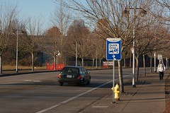
Twice in the last few weeks I’ve ridden my bike along an unfamiliar route. Both rides were enjoyable; but the key difference was how difficult it was to find my way.
On the first ride, through an area where I’ve lived and ridden regularly for the past four years, I had to bring a personal tour guide. On the second ride I navigated an area I had not seen from a bike seat in nearly a decade, along a route I was not familiar with; but I did it completely solo, with no tour guide and no map.
I live in Tigard and regularly travel to downtown Portland via the Beaverton Transit Center, but I had never ridden my bicycle between the latter two locations. Whenever I was traveling from Beaverton into Portland I had a choice: stick with the bus and train schedules I’m familiar with, or ride on a route where I’m likely to get lost.
In an effort to step outside my comfort zone, I called my friend Harmony Bliss (before you ask, she acquired her unique name through marriage, not directly from her parents) and asked if she could share her experience of commuting on a bike over the hill and on the multi-use path adjacent to Highway 26.
Harmony agreed to meet me in Beaverton and lead me on a ride into Portland.

but where will we end up on the other end? How do you even find this path without a guide?
She started us out heading north along Lombard Avenue and we weaved through neighborhoods as she called out out upcoming turns so I could anticipate where we’d be going. Occasionally we’d take a break from riding so she could reorient me to where we were on the map.

In the end, the ride was surprisingly pleasant, including a section on Highway 26, and the elevation gain was much less challenging than I had anticipated.
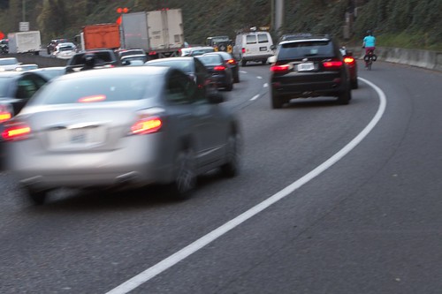
when cars are driving slowly at rush hour.
I’m looking forward to riding it again, but I’m not sure if I could duplicate the route on my own without more practice. The Highway 26 multi-use path is a good connection for bike traffic; but I was shocked at how hard it is to find from surface streets.
Harmony and I only caught a glimpse of one way-finding sign on our ride. We noticed exactly zero directional signs in Beaverton and it wasn’t until we were five miles from downtown that we finally encountered the first and only sign pointing us to Portland. Can you even imagine the tables being turned? Ever heard of a freeway or auto-centric arterial with such little signage?
Contrast that experience with a ride I took recently in an unfamiliar part of Eugene.

like to ride today?
After a ride around Eugene with two people familiar with the city’s bike routes, I was left to venture out on my own to visit Co-Motion Cycles, located on the opposite side of town from where we parted ways.
It’d been more than 10 years since I’d ridden any significant distance in Eugene and I was unfamiliar with the route I’d be taking. When I brought up my concerns during the ride with friends they tried to put me at ease with instructions like, “Just head east and you’ll find your way.”
At first I didn’t believe them (I have a terrible sense of direction), but in the end my ride was as simple as they said it would be.
I was even able to take an unplanned detours to visit a local businesses, all without needing to look at a map or directions on my phone.

The route I took to Co-Motion was mostly along the Fern Ridge Path, an east-to-west corridor that passes through neighborhoods and crosses a number of busy roads.
Each time the trail stops in a neighborhood there’s a sign pointing you in the direction where it picks back up again. When the trail crosses busy streets the path either splits in two, one way going under the road and the other crossing it at street level, or there are signs directing you to where the trail begins again on the other side.

find where a trail starts back up on the other side of a road.
It made me think back to my ride with Harmony. How many years ago would I have tried riding from Beaverton to Portland if I knew there were signs to lead me?
Stepping outside my personal concerns for a minute, another thought hit me: how many people want to ride a bike around Washington County, but choose not to because they can’t find their way?


Thanks for reading.
BikePortland has served this community with independent community journalism since 2005. We rely on subscriptions from readers like you to survive. Your financial support is vital in keeping this valuable resource alive and well.
Please subscribe today to strengthen and expand our work.
That Sunset Highway MUP can be hard to find. But, are cyclist allowed on the Sunset Highway in that stretch? I have have always gone though the zoo and Washington Park.
Mindful Cyclist,
Yes. Bikes are allowed on Hwy 26 between the Zoo and Goose Hollow. It’s much more direct than winding through Washington Park.
26 doesn’t go through Goose Hollow, but rather just south of it. Bicycles are allowed on Sunset Highway in both directions from Astoria to the Civic Stadium exit (last exit before the tunnel). ODOT is very good about posting mandatory exits on the freeway, there are none westbound, you can keep pedaling along westbound there on the mainline.
That said, having taken it both directions, the 217 interchange is absolutely terrible by bicycle if you’re not coming from/going to 217. At least they fixed the deathtrap of a bridge at the OR 8 exit; when I worked at the Oregon Zoo back around the turn of the century, the overpass over the flyunder to OR 8 truly scared me since the only way past that exit at the time was to take the lane on a freeway.
“ODOT is very good about posting mandatory exits on the freeway”
There maybe… but not on I5. Bikes are legal from the Beaverton-Tigard Highway Interchange, MP 292.20 (Kruse Way, Tualatin) all the way to the Crater Lake Highway Interchange, MP 30.29 (in Medford). The law allowing bikes on the freeway states that “The closure of the above sections to nonmotorized vehicles shall become effective following the erection of adequate signing”
That said, there’s no sign for NB bike/Ped/Horse traffic (and yes, I’ve seen someone riding in a horse drawn waggon on I5) notifying them that they must exit the freeway at MP 292.20 that I saw last time I was out there last year (I keep checking when I’m down there). ODOT has been notified, and nothing’s been done.
http://www.flickr.com/photos/ufobike/sets/72157606174789242/with/2670686690/
I’d have to doublecheck again, but I could have sworn I’ve seen it before… then again, I long ago tagged the freeways in Oregon for bicycle accessibility on OpenCycleMap and have largely relied on my GPS to remind me since Oregon and Washington both seem to make all signs that apply to bicycles the same size they’d use on a cycleway instead of using the size appropriate for the conditions as required for some bizarro reason (seriously, 1″ lettering on the bicycle wayfinders and mandatory exit signs? By the time I can actually read that, I’ve already missed my turn!)
Well, crap. I have been doing this for over two years. I had no idea and I think a lot of other people do not know either as there are a lot of people that seem to go that way through Washington Park. And, it basically is too dark to ride through now.
Here’s a video of a gravity bike taking a popular zoobomb route from Washington Park: http://www.youtube.com/watch?v=7pkDxQK3bDc
starts at 2:00
The route’s called Hellway, and it’s a LOT of fun… I regularly ride it on my commute into PSU.
Just commuted home on it and much more direct! I will have to start doing this more often. I honestly don’t mind cutting through Washington Park, but hate going down that steep hill on Salmon St.
Thanks all!
Here’s the route for 26 through town.
ODOT says yes for riding a bike on the shoulder of the east-bound Highway 26 from Sylvan to the Jefferson Street exit.
If there’s no sign saying you can’t, you can. Also note that there are signs telling you to exit at Jefferson if you’re on a bicycle. That’s the westernmost bicycle restriction on US 26, it’s open all the way to US 101 to bicycles from that point west.
This sort of thing is why I thought a route-finding business might be useful! 🙂
This is sort of link-spammy, but it’s topical for the article. I’m happy to be your local expert: http://activecommutepdx.com/
(though the Highway 26 path is one I’d have to take lessons on too!)
I’ve always thought it would be a great idea to have names for the greenways/bike routes we have going through town. For example, there’s the eastside route that starts out on Ankeny, hops up to Couch at 33rd (I think), continues east while also moving to David and Everett along the route, eventually joining to Burnside somewhere in the 70s. I think this is a great route, I used to take it riding from my place in Buckman to work at Mall 205 even though it was slightly more out of the way than the Harrison/Mill route that goes over Mt. Tabor. But it’s hard to explain to others this route because it has not real name, because I have to say “you could take that route that runs along Burnside and goes along Couch and Davis and Ankeny” at which point I’ve lost them. What if it were called the Central Eastside Greenway (or something else more specific), or if the second one I mention was called the “Mt. Tabor Greenway”? These would be much easier to refer to and tell people about.
Some do have names, such as the upcoming “50s Greenway” or the “Going St. Greenway”, but those kind of names are really only known to those of us who read this site. I think that if each greenway were given its on official name that would be posted at different points on the route (above the existing signage, for instance) they would gain an identity that people could remember. If the route that runs along 41st in SE and runs along 37th in NE had signage saying “40s Greenway” than when someone is visiting a different part of town and sees that signage, they might think “I didn’t know this route runs all the way out here!” People unfamiliar with the existing routes probably just see a bunch of sharrows on the roads, but don’t really know where they lead to.
We actually have that already, but they tend to be complicated like “Mill/Madisson/Main/Morrison Greenway” or “Clinton/Woodward Greenway.” The PBOT names for these are all listed on the relations for each neighborhood greenway on OpenCycleMap, but these don’t render.
I really wish that these cycleways had numbers, since these are easier to identify at a distance with signage, we have standard local cycleway network route sheilds already, and numbered route references are easier to render on a map, as demonstrated by Dallas and London.
Harmony Bliss. That’s the best name I’ve heard in a very long time! 🙂
Met her last night at the BTA/WTA event last night. Nice gal.
That’s funny, I started working on the Westside, so just the other day I looked this route up on [popular search engine, mapping site, bicycling feature]. Which also happens to be the answer to “how to find your way without signage or a personal tour guide.” Print a map and/or make a cue sheet. Put it in a place easily accessible on your ride. Put it in a [popular reclosable plastic bag] if it’s raining. (Better yet, get a proper handlebar bag with a map pocket.) Wear a headlamp if it’s dark. Then you don’t have to rely on the government to lead you, and you can pride yourself on your independence and preparedness, and can smirk at wayfinding signs and say “yeah thanks, I know.”
Political commentary aside, I’ve had good luck with a Garmin Oregon set to bicycle mode with a bike mount, loaded with the latest OpenStreetMap sectional on an SD card as the enabled map. I find it odd that Garmin ships with NAVTEQ maps when NAVTEQ doesn’t map for cycleways at all, but all Garmin devices (even car oriented ones!) support navigation by bicycle.
I’d recommend that to someone who takes unfamiliar routes often, has the money, and/or just likes stuff like that. But generally once you’ve gone a certain way once, you subsequently know the way, so if you’re only doing one or a few unfamiliar routes, the old-school/cheap/simple approach works fine.
The first time I took that path I was not expecting it. The max was backed up for about an hour, so I just went through the zoo. It went well enough until the path ended (around 217) and I got lost in the neighborhoods for some time, eventually ending up on Walker, which isn’t the best place to be.
You point out one of the fundamental inequities between cyclists and drivers. Drivers get the direct, easy to find routes while cyclists get relegated to back roads, hard-to-find bike paths, and complex routing. For example, I used to commute from Cooper Mountain in Aloha to the east side of Gresham. By car it was 10 turns to drive the 30 miles. By bicycle it was 37 turns, included one informal connector, one path through the woods, and various other technicalities that make a cycle route difficult to navigate. When I go by car I just get in the car and go. When I go by bike I carefully plan my route at home, looking for some combination of shortest distance and safety, and then hope I can actually remember it.
W. Vanue and J. Maus. respectfully, Maybe when you do an article on a route, you could publish a map of the region? Sometimes we all don’t know about these routes, and maybe we could take them more if we knew from where to reach them. ja.
That’s a great point.
Here’s a link to the route I rode into Portland:
http://g.co/maps/xbnc9
Here’s a link to the route I rode through Eugene:
http://g.co/maps/5nxfd
OK the route into Portland had 32 turns by bike and was 7.3 miles, or by car 19 turns and 7.2 miles. Still a ways to go yet.
I think one of the worst-signed routes in Portland is the I-205 bikepath, especially the NE quadrant section. The signage, when there, is confusing, but mostly, it’s just not there. The first few times I biked it, I had to stop and ask people for directions. It switches sides of the freeway a lot without any indication to the poor cyclist who suddenly finds the bikepath just GONE, and dodges over horrific onramps and busy roads without any indication of where you are supposed to ride. Uugh!
I live in central Beaverton (Cedar Hills) and commute to Tigard for work and I can totally echo the author’s statements about poor signage. I mapped out my route to work when I first started commuting via bike, but otherwise I never would have been able to find my way.
My biggest complaint is the incomplete bike lanes throughout Beaverton and Tigard. One block there will be a bike lane and the next it will be gone and you’ll be forced to take a lane and ride in traffic.
Bike lanes often disappear as you come up to stop lights and major intersections, too. Seems to me that those would be the most important place to have bike lanes…
Another problem that I often run into is bike lanes in neighborhoods where there are no sidewalks, so I’ll have foot traffic coming directly at me, with nowhere else for either of us to go but out into the street. It’s certainly not a safe situation.
The one issue I have no had is trying to find a safe way to get into Portland. I often use the Hwy 26 multi use path, since I live only a mile or so from the start of it. (though I go through the zoo, not on Hwy 26) I’ll also use Beaverton-Hillsdale Hwy-Capitol Hwy if I need to get to SW Portland.
When you do end up on SW Walker from SW107th… Turn left, take the first right onto 106th and immediate right onto the (paved) alley. Then right, left, right onto SW Cabot (becomes Center), and then you’ll find Lombard along there. My backyard. And I never ride along that stretch of SW Walker.
Way finding signs would be good. However not provided by the City of Beaverton- the trail starts outside the city limits.
paved alley? Do you SW Sunnyhill Lane? That trail connects SW 108th Ave to SW 110th Ave.
“how many people want to ride a bike around Washington County, but choose not to because they can’t find their way?”
Good question– the answer is probably “a lot”.
Most people either stick to the arterials, which may or may not be safe to bike, or use mapping software of one kind or another to figure out how to get where they need to go. Or they don’t ride.
Washington County has a ways to go to have a connected system for cyclists and pedestrians. I’d urge everyone to make their views known here:
http://www.co.washington.or.us/LUT/Divisions/LongRangePlanning/PlanningPrograms/TransportationPlanning/bikeandped/inventory-mapping.cfm
The comment period ends January 1, so get on it!! If Wa Co doesn’t know about missing links in the system, they can’t get it on their radar to fix!!
I added a bunch of comments to areas that I think need improvement, both along my commute and around my neighborhood.
It’s frustrating, because in so many places Washington County is so close to being very bike-friendly, but they just don’t seem to follow through. Having bike lanes end a block or so before major intersections (like around Beaverton-Hillsdale and Lombard, Allen and Hall, Allen and Lombard, etc) are the major contributors to this.
Another example is the bike lanes on Cedar Hills north of Walker suddenly going away once you reach a major shopping area. It makes no sense. I’d love to do more of my shopping via bike at New Seasons, Winco, etc., but the complete lack of bike lanes in that area make it very prohibitive.
Well, if you want to see the mindset of most Washington County residents, all you have to do is look south.