The State of Oregon’s “Scenic Bikeway” program has taken a nice step forward. This week, the State’s Bicycle Recreation Coordinator, Alexandra Phillips, unveiled a website that features detailed maps and route information on the Willamette Valley Scenic Bikeway.
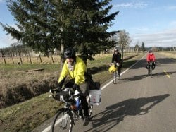
The Willamette Valley route is the first officially recognized scenic bikeway in the state and it’s referred to as “a prototype” for others yet to come. The 127-mile route begins at Champoeg State Heritage Area just south of Wilsonville and ends at Armitage County Park just north of Eugene.
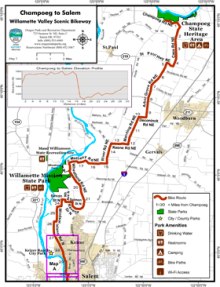
At the new website, riders can find printable maps and loads of information like places to camp, historic points of interest, elevation profiles and tips on side trips to take along the way. They’ve even broken the route down into four segments if you only have time for a one-day ride.
The effort to create a statewide network of scenic bikeways started well over a year ago and it’s being spearheaded by Phillips through the Oregon Parks and Recreation Department (OPRD).
The scenic bikeway concept originated with the folks behind Cycle Oregon (ride founder and former Oregonian columnist Jonathan Nicholas is a major proponent). Within the OPRD there is a Scenic Bikeway Committee that is working to designate more of the routes based on nominations made by the public.
Learn more about the Willamette Valley Scenic Bikeway at the official site of the Oregon Scenic Bikeways program… and start planning your ride today!


Thanks for reading.
BikePortland has served this community with independent community journalism since 2005. We rely on subscriptions from readers like you to survive. Your financial support is vital in keeping this valuable resource alive and well.
Please subscribe today to strengthen and expand our work.
One great thing that the state added to the maps is the location of campgrounds along the route, along with sources of water, and other bits of info. The new “adjusted” route has some differences from the old one – most notably it now stays firmly on the east side of the Willamette River, and no longer crosses the ferrys. The only real hills on the route are in the Salem area. Most of the route is low traffic, and Alexandra Phillips and the scenic bikeway committee (who among other notables hosts the former head of Cycle Oregon, Jerry Norquist) have done a great job putting this together and making it happen, and it really serves as a model for what is to come.
My only complaint (and this is based off reading the website a couple days ago) is that this route still has no campsites at the midpoint (approximately the 60-65 mile mark). Touring cyclists can expect to do 40-70 miles when fully loaded, and the current incarnation of the scenic bikeway still does not address that issue. My hope is that the state will address it at a later date with this and other routes.
One possibility for camping along the route is some of the undeveloped OPRD (Oregon Parks & Rec) land along the Willamette River which canoe and kayak users currently take advantage of for camping on multi-day river trips. OPRD has a tremendous opportunity to leverage existing assets for another class of low-impact, self-policing users who respect the land. Hopefully, the various stakeholders in this issue will work to fill the (minor) remaining gaps.
Awesome site, awesome project, awesome job overall – way to go!
I agree with comment #1. The state maps are great, but finding a place to camp is not.
I’m doing this ride soon. The maps are helpful, but some info about how to get to Champoeg state park would be great. I see it on google maps, but there must be a recomended way to get there. Is there something I don’t know? is there a reason the bikeway starts where no one lives?
Great to see that this is off to such a great start, but it’s not clear to me why we wouldn’t want to include non-camping accommodations/attractions/places to eat along the way, too.
Might as well get local B&Bs, restaurants, etc. on there, no? Not everyone wants to schlepp along backpack-load of stuff, and plenty of people simply won’t consider camping.
My wife and I have done a lot of bike touring with a tent, but the best bike trip we ever took was in Austria, along the Inn River Valley, and all we took was a couple changes of clothes and a credit card. The entire route — which went on for days, and was completely off-road, on old barge-towing paths along the river — was dotted with infrastructure (Bike & Breakfasts; Beer Halls for Bicyclists; small bike shops, etc.) that were explicitly catering to bicycling vacationers.
To build broad support for linear parks and scenic bikeways, we should welcome and encourage not only bike campers, but also the sans-panniers set.
Steve (#3) – My guess would be because Champoeg is a good jumping off point for a recreational route, and in part because “scenic” and “urban” usually don’t fit well. There are few comfortable routes out of the city to the nearby state parks. (Many of them are perfectly safe, but along high-traffic roads, and nearly all of them have at least one unpleasant stretch)
As for routes to Champoeg, you could try this route, which has one steep climb in Oregon City, but is otherwise fairly smooth. There is another route through the Oregon City portion that I haven’t mapped yet which uses the little-known “secret” pedestrian tunnel/bridge under the RR and over 99E.
http://www.bikely.com/maps/bike-path/Portland-to-Champoeg-State-Park
Note that Stig’s route will take you up to 800′ on Pete’s Mountain Road (ouch), and may be difficult to use starting this November for the next 2 years due to the impending closure of the Oregon City Bridge. You can avoid Pete’s Mountain by taking SW Borland to SW Turner to SW Mountain Rd, which only climbs to 400′. It’s a really good return route from Champoeg, and takes you over the Canby Ferry, which is free for bikes.
Nice maps — my only quibble is with the elevation profiles, which use various (and fairly ridiculous) vertical exaggerations. Let’s not scare people unnecessarily. A “total elevation gain” (readily available from Bikely.com and elsewhere) would be useful, too. But, hey, nice work! I prefer using the Buena Vista Ferry, as there’s nice back roads into Albany, but since it’s closed part of the year it’s probably not practical to show as the preferred route.
oh, yeah, and ditto on the mid-valley campsite complaint. Nothing as far as i can tell in the valley proper between Champoeg SP & Brownsville city park, with partial credit to Willamette Mission SP (group camping). Needs fixing.
SteveG (#4) – Two reasons to limit that: one, to prevent cluttering up the map too much with icons, and two, a lot of businesses fail within the first year, especially restaurants. I think it would be good if they added hotels and B&Bs to the list, because those stay pretty stable, and restaurants tend to cluster around them, so if you know where the hotels are, you know where much of the food is.
One of the big reasons for including campsites is that the credit-card set can find somewhere to stay in every city and almost every town along the route, within a couple of miles. The touring set is limited by places where it is legal to pitch a tent, and typically underserved in terms of information and services. I think OPRD has put together a balanced approach, rather than the traditional catering to the sans-pannier set.