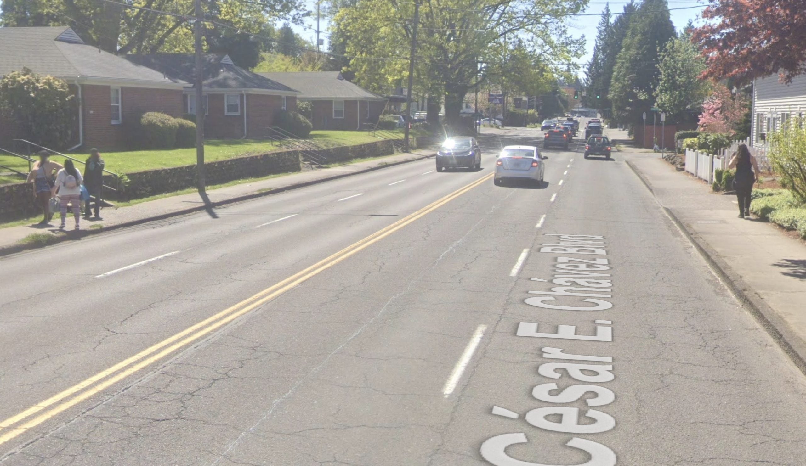
The Portland Bureau of Transportation (PBOT) will reduce the number of driving lanes and add a new crossing treatment on a stretch of Cesar E Chavez Blvd where a woman was hit and killed by a driver one year ago.
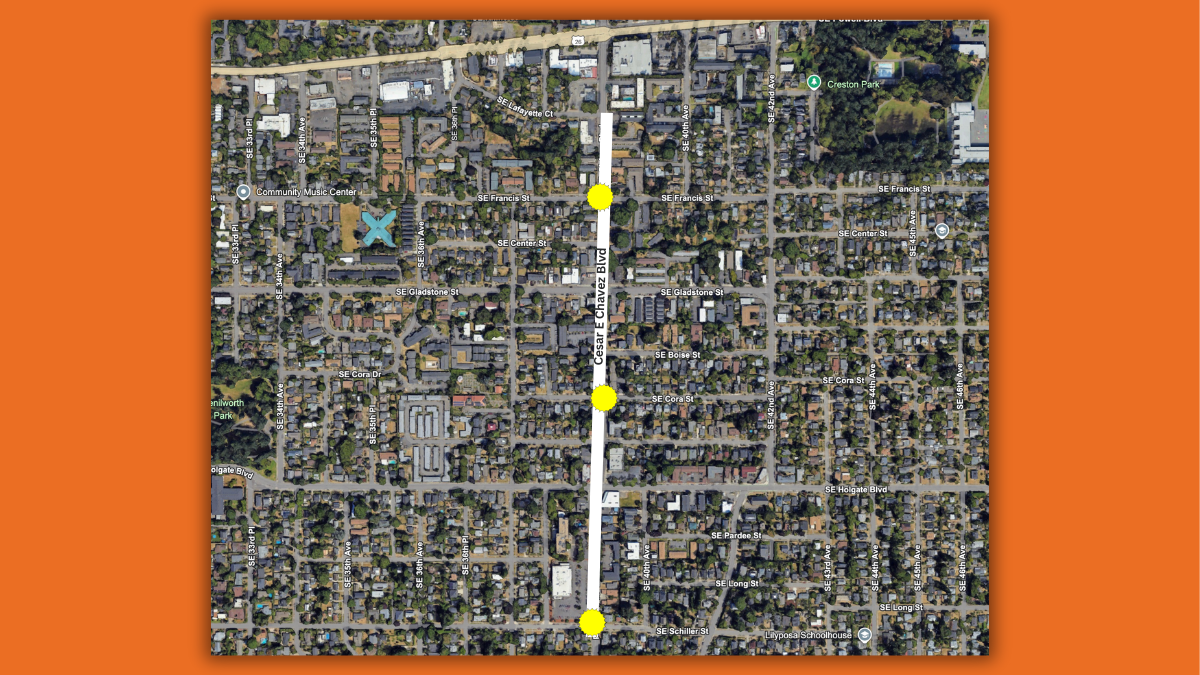
PBOT won a grant last year through the Oregon Department of Transportation’s All Roads Transportation Safety Program (ARTS) that will fund a $2,232,000 project to reduce Cesar Chavez Blvd from four lanes to three lanes between SE Lafayette (just south of Powell) to SE Schiller. The project will also rebuild the traffic signal at SE Holgate (to protect driver left turns) and relocate the bus stop at SE Holgate closer to the crosswalk.
A three-lane cross-section (one in each direction plus a center turn lane) gives PBOT the ability to build safer crossings. They intend to add $550,000 in their own funding (from the Fixing Our Streets program which is funded through the voter-approved local gas tax) to add one new crossing. The plans are not finalized yet, but the crossing could come with a concrete median island, curb extensions, and a marked crosswalk and new lighting. The three crossing locations under consideration are SE Schiller, SE Francis and SE Cora.
The lack of safety on Cesar Chavez Blvd has been a hot topic for many years as fatal collisions with walkers and bikers have piled up.
In January, 2025, 71-year-old Tuyet Nguyen was walking across SE Cora and Cesar Chavez when she was hit and killed by someone’s car. In a brief description of the project, PBOT acknowledged the tragic legacy of Cesar Chavez Blvd. “The community is very interested in getting more crossings on SE Chavez. There have been several recent pedestrian fatalities on Chavez, including at SE Cora St.”
This project is still in development and PBOT is just beginning to reach out to the community for feedback. If you’d like to learn more, the project team plans to attend the Woodstock Neighborhood Association meeting on Wednesday, February 4th at 7:00 pm (on Zoom or at Woodstock Community Center, 5905 SE 43rd Ave).


Thanks for reading.
BikePortland has served this community with independent community journalism since 2005. We rely on subscriptions from readers like you to survive. Your financial support is vital in keeping this valuable resource alive and well.
Please subscribe today to strengthen and expand our work.
I don’t know it could interfere with traffic on Powell and what if people divert to McLoughlin. Better check with ODOT first to make sure they won’t veto this too.
There have been 4th pedestrian deaths on 39th in the last 5 years, yet only one has spurred action from the city?
EXACTLY the point I was going to make. This street is a DEADLY STREET, but PBOT cannot conceive of making it a safe street. As I have repeatedly noted, PBOT Director Millicent Williams was terrified by spending a few minutes sitting at the bus stop where a driver killed Jeanie Diaz, yet she has done nothing to make that intersection safer. And since Diaz’s death, others have died on Chavez.
This street was designed to have one lane of motor vehicle traffic in each direction, and as long as PBOT keeps TWICE AS MANY LANES OF SPEEDING TRAFFIC as the street was designed for, along most of the street, it is an indication of PBOT’s priorities.
As I have repeatedly noted, PBOT could also use existing traffic lights to slow traffic, by having them AUTOMATICALLY turn red at shorter intervals. They could end turning on red. They could … oh why bother listing all the simple low cost/no cost ways to make the streets safer, when Director Williams doesn’t care if more people die on Chavez?
“Director Williams doesn’t care if more people die on Chavez?”
Is that even remotely fair?
Yes, it is. Caring in Portland is almost always performative. If you were a grieving friend or family member, you’d want action, not performance of caring, which is what Portland officials are mostly good at.
Just a gentle note of caution here, Fred. Critiquing the motives of a Black woman in a senior leadership role can raise concerns, especially given the broader context of restorative justice and redemption narratives that are often centered in Portland politics. When someone has been elevated to a position of power as part of that framework, it’s particularly important to avoid personal judgments about whether they “care,” and instead focus on systems and structures. Centering intent over impact can unintentionally reinforce harmful tropes.
Wild times when a public official cannot be critiqued for policy failures when they have checked the right identity boxes—at which point criticism must be gently wrapped in bubble wrap and routed through a systems-thinking committee. Apparently accountability is canceled, but only selectively. Bonus twist: even a convicted felon gets a vibes-based immunity shield. Portland never disappoints.
from a distance, inaction and a lack of care look awfully similar to me.
This is an article about PBOT spending money to make Chavez a safer street, so I’m actually not sure what you’re on about.
Look at the comment Lois responded to:
Lois responded:
Then adds more explanation.
It seems clear to me what Lois in “on about”.
I would love a crossing on Francis! Aside from the safety issue, maybe it would be a good start to making the street a greenway, as they considered a few years ago.
As soon as drivers exit the 3-lane area they hit the pedal to the metal and speed even more, so I feel sorry for people living just beyond the project boundaries.
Well, Chavez already goes down to two lanes at Schiller, so no worries on that end. And since the light at Powell is red about 35% of the time (BS estimate on my part), there won’t be too much flooring it into the 4-lane stretch.
But yes, Chavez from Powell to Sandy will remain a deathtrap for the foreseeable future (and the several blocks just north of Powell have always been one of the most harrowing stretches, IMHO).
Yeah, there is only one crossing – at Franklin b/c the Creston elementary school boundary extends into a sliver across Chavez. Then there is nothing until Clinton. Mostly b/c the streets to the east all dead-end from Kelly until Brooklyn, I imagine.
Right and one of the big problems in that stretch is the S-bound downhill traffic tends to speed all the way from Clinton. Having a ped median somewhere near Brooklyn St would limit that speed and give peds visible priority.
David, that’s the “We can’t ever regulate anything” argument, which is beneath you.
If Chavez is already dangerous (and it is), then efforts to make it safer are worthwhile, even if they don’t improve safety 100%.
There’s this weird neurosis about being able to pass. I think that’s what causes the pushback to road diets. Even if a 1+1+turn lane makes traffic flow more consistently, or at the very least the same, the popular thinking seems to be that ‘slow drivers’ “cause traffic” (all drivers cause traffic lol) and being able to pass them is a god-given right that cannot be taken away.
There’s a lot of evidence that 4 to 3 conversions reduce conflict points. Generally, they also have fairly similar capacity where some are successful at >20k ADT. That means that most of Cesar Chavez might fit that redesign.
I completely agree with you, and had PBOT proposed a project to put in a series of choke points all along the way, I would support the project; but building just one is not only asking for more crashes elsewhere, and clearly phase 2 in a later year followed by phase 3 years later and 4 further out calls for increasing funding through phases for PBOT, which I find blatantly cynical on their part – they are more interested in funding staff personnel in the future than in providing needed safety that is needed right now. They did it this way for years in East Portland and now they are doing it citywide.
I’m also surprised by the cost – it looks far higher than it should be – but no doubt that’s from my living in NC where our local costs are much lower for similar projects.
Another possibility that I don’t like as much but might sell PBoT because of higher ADT would be to retain 4 lanes and have ped medians, sort of like inner Burnside. My hope is that PBoT can use the road diet south of Powell as leverage to install a ped median just North of Powell. After the sky doesn’t fall, we might be able to see a slow transformation further north.
I would love to see a graphic showing the where the serious crashes and deaths have occured on Cesar Chavez over that last 5 years with this segment highlighted. I think this is very positive step, but my first impression is that it seems pretty modest and likely chosen because it has less traffic than other segments rather than less danger.
So, I did some digging and this is as close as we’ve got right now. https://geo.maps.arcgis.com/apps/webappviewer/index.html?id=0f2128152a764143bac02c1a869a5a51
There’s a promising one from Oregon Walks but it was only 2017-2020 sadly. Seems like a gap in mapped data.
thanks!
Take a look at City of Portland’s “Vision Zero crash map” with data in 2026. You can access it from the Vision Zero Dashboard Guide:
https://www.portland.gov/transportation/vision-zero/vision-zero-dashboard
Traffic Counts (volume, speeds, etc.) can be accessed from here:
https://www.portland.gov/transportation/traffic-operations/how-we-gather-traffic-counts
Cesar Chavez north of Powell is >10,000 ADTVolume.
Cesar Chavez south of Powell is < 10,000 ADTVolume
ADT = Average Daily Traffic
Another consideration is adjacent land use and destinations. Crossings near schools, parks, and other destinations will factor into where treatments are applied, particularly if it can move multiple objectives forward (e.g. PedPDX, Safe Routes to School, Pedestrian Districts, High Crash Corridors, etc.).
I wonder if this would prove leverage enough for PBoT to install a median at or near Tibbets. As Laura said above it is technically within Creston’s boundary. Would that trigger SRtS funding?
Also, some DOTs look at a 4->3 conversion as possible even up to 20k ADT. I don’t know enough about the criteria for that, but the highest I can find on Cesar C is S-bound just north of Powell with 12.5k ADT.
As someone who used to live just north of Powell, I’ve got to argue that a crossing at Trader Joe’s makes the most sense. Gladstone catches most of the northern portion nicely, but that extra wide section with the dog-leg/chicane in Cezar seems to always have drivers speeding up and coming directly into conflict with people walking, biking, and driving out of the TJs parking lot. It’s the perfect location to slow down drivers and give pedestrians a crossing refuge.
Wish they would keep going all the way up to Hawthorne or Hollywood.
Also curious if we will get curb bulbs at other intersections. The three lane section to the south of TJs is still VERY fast because it feels so wide and so few people are parking on the street.
This is a great point. If I can make it to the meeting, I’ll do my best to bring this up.
Agreed! I live in the neighborhood and getting across 39th to/from the TJs is a nightmare. Fewer lanes and a marked crosswalk there would be amazing.
This is great news! I used to live right there. I still drive into the neighborhood though, and this will be an improvement.
I say build all three crossings!
Based on recent history, the most effective way for a person to influence the design of a street is to die there.
PBOT has admitted this, indirectly. Until there’s sufficient evidence that an intersection is dangerous, than it is unlikely to be improved. I remember hearing this on BP articles related to the SW development and surrounding infra updates
Somehow the perception of an observer, who has seen some streets, isn’t enough? It’s appalling that we have to have a body count. Here’s a hint: if people avoid a place, it’s a bad design. Is this a reasonable application for AI? Because it seems like our human designers find reasons not to fix stuff.
Unfortunately, people avoiding a place is also used by traffic engineers to justify not making improvements, because they view that as showing there’s minimal demand.
So, for instance, people avoid walking or biking on a street because it’s dangerous, so that’s viewed as there not being enough people biking or walking to justify safety improvements.
I don’t think the issue is that PBOT doesn’t want to fix dangerous crossings; I think the problem is they have enough money to fix one, and have to choose between one that people avoid because they perceive danger, and another that people can’t avoid despite the danger, and where someone has been killed.
If we had a better functioning state government, we might be able to raise gas taxes to provide more money for cities to fix problems before people are killed.
Way back in the middle of the last century, Long St. connected Cesar Chavez (formerly 39th) and 40th Aves. There used to be a crosswalk there as a result under Oregon law that allowed people direct access to the grocery store (previously Safeway before later becoming Trader Joes). See this 1948 traffic flow map from MultCo Library which includes Long Street.
Back in the late 1970s, Woodstock Neighborhood Association petitioned for the development of 4602-4710 SE CESAR E CHAVEZ BLVD to maintain an easement for pedestrian connectivity. You can see the easement today on Google Street View. The later widening of Cesar Chavez into the 4-5 lane we all now today has diminished use of this historic crossing and reduced neighborhood connectivity.
A mid-block crossing improves pedestrian safety by designating space for people to cross, provides direct access to a grocery store, reduces speed by limiting the road space (assuming a median island refuge is paired with a 3-lane configuration), and enhances visibility of pedestrians. If the community wants to see this crossing restored now would be the time to rally in support for it.
Great historical perspective! Thanks!
There are sewer easements through the former SE Long St right-of-way, but the right-of-way was vacated by the city, going to the property owners adjacent, and there is no public access walkway easement mentioned in the street vacation for the property you’re talking about. So I think the ship has sailed on that idea.
https://efiles.portlandoregon.gov/record/3974958/file/document/
Item b-2 on the vacation confirms “no building or structure of any kind be built or erected within a distance of ten feet from the centerline of any such utility (i.e. water or sewer).” Record of sewer line is viewable here.
Item b-3 reads, “That an easement over the entire length and full width of the street to be vacated is reserved for maintenance or replacement of existing sewers and for construction of future sewers, and that no building construction, material storage, or tree planting will be permitted within the vacated street.”
There remains a pathway which you can walk through today. In fact I wave and chat with the neighbors here whenever I walk through. While the pathway honors the city vacation requirements as well as the community vision from yesteryears, the pathway effectively ends at Cesar Chavez.
If I’m understanding what you are implying is that Oregon law on crosswalks does not apply here as this section of Long Street was vacated. But my point is that the neighborhood community vision to increase access to the grocery store and neighborhood connectivity can still be upheld if a midblock crossing were established here instead of Schiller where there already is a legal crossing.
I do want to say that I really want safety and don’t think our current people making choices will get us there while maintaining the integrity of the road infrastructures throughput capacity. Foster road is now a terrible snarl of traffic along many points, notably at Holgate and again at 82nd. Holgate itself also becomes affected at Foster Blvd with wait times of 3-4 light cycles from 7-9am and 2-6pm weekdays. I go through the neighborhoods very often instead of waiting for that crap. Another example is Division which has seen severely diminished throughout and terrible traffic as a result.
If only we used roundabouts here we could have safety while maintaining throughput integrity for a (hopefully soon) growing population.