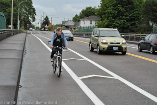
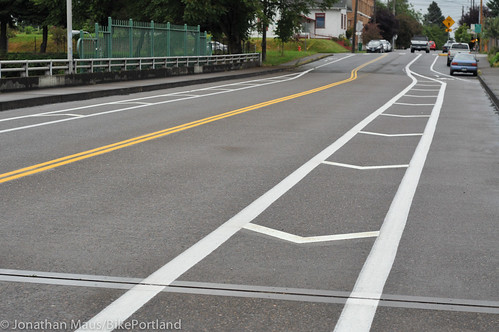
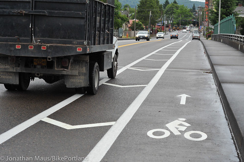
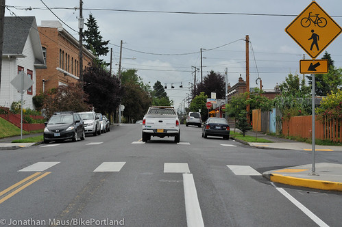
As we reported yesterday, PBOT has just installed bike lanes on a short stretch of North Skidmore Street. They go from Michigan Ave to Maryland Ave (one block east of Interstate). When I went by yesterday morning they hadn’t finished applying all the striping into the buffer zone, so I wanted to share some updated photos. I also wanted to address a few things that came up in the comments to yesterday’s story.
First, here are a few more photos of the completed lanes…
In the comments of yesterday’s story, many people expressed their desires for these lanes to go all the way east to NE Martin Luther King Jr. Blvd. Skidmore is a key east-west connection between the I-5 corridor area and destinations in northeast Portland. However, these new bike lanes end rather abruptly at Michigan, one block west of the Mississippi Street. Why? There are several reasons. First, this striping project is part of the Going to the River project. That project directs bicycle traffic from Swan Island to the Going Street neighborhood greenway via Michigan, so there’s no money in the budget for doing anything beyond what those plans call for.
Another reason we’re not likely to see bike lanes continue is that PBOT would say “there isn’t room.”
Note that this new bike lane is a whopping 11-feet wide (six feet for the lane, five for the buffer) on the I-5 overpass. The only reason PBOT could do this is because there is no designated auto parking lane on the bridge so they had ample width to work with. The actual roadway width doesn’t change on either side of the bridge, but since PBOT allows auto parking, the usable portion of the road effectively narrows by about 8-10 feet.
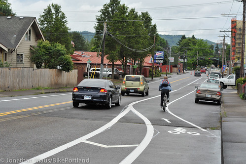
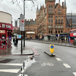
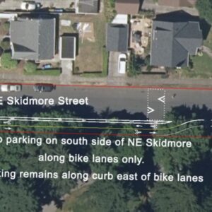
One of the saddest things I see on our streets is when a bike lane is forced to turn because of auto parking. It’s a clear sign of our misplaced priorities. We sacrifice the comfort of people bicycling in order to allow people to park cars (usually for free) on the street. See the photos below to see what I mean…
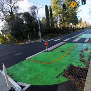
In addition to car parking spaces, the recent installation of curb extensions (a.k.a. “bulb outs” and often accompanied with planted bioswales) also limits PBOT’s ability to build continuous and direct bike paths. This is an emerging issue throughout Portland. The City builds curb extensions because they improve crossing safety for walkers — but they also have a negative impact on the bikeway because they create pinch-points where people on bikes are effectively shoved out into the street to be even closer to motor vehicle traffic.
These new bike lanes on Skidmore are nice; but they also highlight some important issues for us to consider going forward. Will we reach our ridership and bikeway quality goals if we continue to allow bike lanes to abruptly vanish once off a specific route? Will bicycling ever appeal to a broader range of Portlanders if we continue to let the free storage of private vehicles take priority over safe and direct bicycle access?



Thanks for reading.
BikePortland has served this community with independent community journalism since 2005. We rely on subscriptions from readers like you to survive. Your financial support is vital in keeping this valuable resource alive and well.
Please subscribe today to strengthen and expand our work.
I think it is disingenuous to state there is not room to build bike lanes east of Michigan; there is plenty of room if remove on-street parking from one or both sides of Skidmore.
Going to the River is great east of MLK, but the route is convoluted between 7th and Interstate. Bike facilities on Skidmore from 7th to Interstate would fix that. This stretch of Going to the River is hard to follow and requires crossing MLK without a signal, and encourages riding the wrong way down Vancouver and Williams. These routes need to be simple and legible to be effective.
7th is a great north/south street 9expcept for crossing I-84) and should be developed into a greenway with some diverters.
Interstate needs a 10.5′ vehicle lane striped adjacent to the bike lane. This would help keep cars in their lanes, hopefully slow traffic to the 30 mph posted limit, and show cars and bikes where the buffer is between the modes, and where it disappears and becomes dangerously close.
I think 7th is a pretty uncomfortable street for bicycling actually, as long as the ADT volumes are as high as they are between Broadway and Fremont. They also have to get rid of the double-yellow centerline. Otherwise, either remove a lane of parking for bike lanes, or put in diverters at Broadway and Fremont, or better yet BOTH. Between Fremont and Alberta, 7th is mostly fine, but it still has that wretched centerline.
Since there are so few relatively flat and continuous N-S routes in this part of the city (Williams, Rodney, MLK, 7th, that’s it) these changes would be very welcome.
Reza,
I can’t argue with any of your points. 7th Ave needs a lot of help to create a safe and pleasant Greenway. What if a few diverters were added at Fremont, Broadway, Knott and the speed limit was lowered to 20? This would be cheap, and set PBOT up for a bike/ped bridge along 7th over I-84, with connections down the bank to the Sullivans Gultch trail. I agree that 7th stinks, but I think it is a great candidate for a greenway.
This is one of the BTA’s priority projects that they released earlier this month — making 7th more comfortable/safe for bicycling from Alberta through the Broadway/Weidler couplet, across a new bike/ped bridge over I-84, then continuing south on 8th or 9th (can’t remember which) all the way to Division. It will most certainly involve placement of a few diverters on 7th between the couplet and Prescott; car access will be maintained but it will no longer be a throughway. Advocacy will be necessary when the time is right, especially if political will continues to be in such short supply.
Why would BTA deviate from the 2030 plan approved neighborhood greenway north of I-84, NE 9th?
MaxD, if we want 20 mph speed limits on 7th, PBOT has to put in diverters to get traffic volumes low enough to qualify for the reduced speed limit. In fact, PBOT should be working on this for every section of neighborhood greenway citywide that does not qualify for 20 mph limits because of excessively high traffic volumes.
As far as diverters on Prescott for the BTA proposal, my own observation is that the problem is not as acute north of Fremont as it is south simply because the grid is restored north of Fremont, allowing drivers and cyclists to use several alternate routes to 7th. But you can never really have too many diverters.
PBOT has applied for $7.5 million in funding from ODOT to “modernize” our older bikeway system including older style bike lanes and greenways. We have until June 30 to write letters in support.
http://www.oregon.gov/ODOT/HWY/REGION1/Pages/stip/stip_enhance.aspx
Other projects on the $150% list for funding include at I205 connection to NE 92nd and Hancock at $1.7 million and $2+ million for “Connected Cully.”
In terms of building a network, Skidmore seems like a such a valuable link IF it actually connected Concord to 7th. The work here is appreciated, but there were few conflicts here to begin with (because of the excess width). This truncated, isolated, piecemeal project seems like a perfect illustration of PBOT’s lack of commitment or vision or budget- or all 3!
Skidmore provides a direct and safe connection between Concord and 7th, intersecting popular bike routes at Interstate Ave, N Michigan, Vancouver/Williams and 7th. The route PBOT is proposing misses out on safe, signalized crossing at Vancouver, Williams and MLK, and the safe 4-way stop on Mississippi. For the cost removing one lane of parking, PBOT is proposing this unsafe, convoluted bike route that fails to make important connections!
I forgot to include this link to PBOT’s proposal: http://www.portlandoregon.gov/transportation/article/256146
“One of the saddest things I see on our streets is when a bike lane is forced to turn because of auto parking.”
Are bike corrals okay though? Seriously. I get your point, but the streets in Portland are being used more and more for private bike parking as well. We can’t have it both ways. I’m as big a proponent of anyone of removing parking for travel purposes, but the sad truth is we live in a city (and there are plenty instances of new bike projects that are going to remove parking, just around me there is the 50s bikeway and the Foster streetscape (which I predict will remove some parking)).
davemess. 99% of the bike corrals are easily movable. But yes, I include bike corrals in that assessment. My opinion is that the movement of people is a higher order of need than the storage of their private vehicles.
And please keep in mind I’m not saying I’m opposed to curb extensions… I merely think it’s something we need to keep in mind as we plan our street designs.
Thanks.
Jonathan,
I think you miss a little bit of the point when you diminish parking as free storage of private vehicles. That row of parking contributes a lot to the environment for people walking, too. A wall of immobile 2-ton objects is the best protection of the sidewalk available, and striped bike lanes simply can’t provide the equivalent. In business districts, the on-street parking makes street-fronting retail viable, and it takes an active street to make walking enjoyable. And yes, curb extensions make crossings safer and more comfortable. So while the parking makes bicycling less attractive, it makes walking far more attractice. Note that streets with lots of pedestrians almost always have parking – there is a connection.
Unit,
I hear you. And I hear that perspective from planners/city staff too. But I don’t really buy it. Yes, obviously, large stationery metal objects create a buffer for walkers and their presence narrows the roadway which effectively slows down traffic… But I would rather we work toward removing free parking from the system and come up with other ways to achieve those goals.
Saying that free parking for cars is somehow a good thing for our city/neighborhoods, and walking is sort of like saying that WalMart is a good thing because they commit to 20% use of renewable energy or they sell organic fruit. Or saying IKEA is great because they use recycled wood products. In my opinion, we would be better off without as many cars parking free on our streets — just like we’d all be better off without WalMart and IKEA and the vast impacts they have on our society because of the consumption they promote.
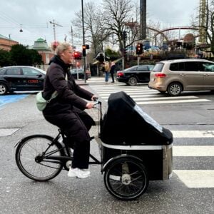
The bike lane should continue straight, with the car parking moved to the left of the bike lane (like we see here in Copenhagen all the time). This way, pedestrians still get their nice buffer from moving cars, bikes benefit from the protection of large stationery metal objects, cyclists are less likely to be “doored” by car drivers, and drivers trying to parallel park do not need to negotiate the bike lane to do so.
I really don’t know why solution this isn’t attempted more often in the US.
Inviting right hooks. Michigan remains a busy street for autos due to the popularity of Mississippi south of Skidmore. there are two properties on the south side west of Michigan. The corner lot could park on Michigan, but the second lot only has parking on Skidmore. You can’t take away all on street parking.
Personally I’m opposed to street parking (either bike or car) on our more major arterials (which also happen to be most of our main commercial areas). Just seems silly to have people trying to parallel park on already narrow streets with speed limits of 35. I know local neighbors don’t like it. But spill over parking into the neighborhoods is the best option in my book (leaving the main streets for actual travel).
Kudos for the literary caption on the last photo.
use a horror-movie style font and put “Where the bike lane ends.” up at the top of that picture and you’ve got the newest hit summer thriller…
Talking about misplaced priorities on this Greenway is correct for this small number of parking spaces.
But by comparison, think about the residents of Cully and Sumner in outer NE. The Going-Alberta Greenway by that point dead ends in an underdeveloped park at 72nd (and we are not even talking about sidewalks here). While it could easily be extended through the park with a multi-use-path (which will happen if “Connected Cully” is funded.) to the 77th Greenway ….but what happens then?
After 77th the residents of Sumner are left with no connection to the west because they lack a safe crossing of 82nd. There is no connection to the MAX stop at Sandy to the east because of gravel roads on Alberta and NE 92nd, where there is ALSO room for a neighborhood park.
We need to connect BOTH ends of this major NE Greenway before we can even think of it as close to completion.
I’m a little confused by your use of “Greenway”. Is it not a greenway if it has bike lanes? I consider the greenways in Portland the neighborhood, low traffic roads, with sharrows on them. Or are those considered Bike Boulevards?
This is a perfect example of confusing, disjointed terminology.
Bike Boulveard term was replaced with Greenway. The Greenway is what you think it is, traffic-calmed, neighborhood streets.
So Skidmore would not be a Greenway? More a bike arterial?
I consider neighborhood greenways to be an enhanced bicycle boulevard, with more traffic calming measures like speed bumps, carfree sections, and diverters. The greenways also may have bioswales and distinctive signage (think of the street sign toppers on Clinton). For example, all of the “bicycle boulevards” in NW (Flanders, Johnson, Overton, Raleigh, 24th) have sharrows, but unfortunately none of them are “neighborhood greenways”.
This section of Skidmore is not an actual greenway in itself, it is a bike lane connection over the freeway as part of the ‘Going to the River” project…which is mostly “Greenway”..or “upgraded residential bikeway.”
http://www.portlandoregon.gov/transportation/article/348945
Here is an explanation and link to the detailed plans….until NE 72nd, where it ends.
You’ll need to convince the locals east of 72nd the park doesn’t belong to them alone.
Yawn. That’s even worse. Now more disjointed and disconnected bike lanes! Man, PBOT could have at LEAST taken out the few parking spaces from Mississippi to the spot captioned in the photo,”where theb ike lane ends”. e. Okay, weird computer problems. Hope that makes sense.