Please welcome our new contributing writer, Tyler Pell. This is his first report.
The fourth Stakeholder Advisory Committee meeting for the Foster Streetscape Plan was held last week, with new proposals presented to the SAC as well as a redevelopment project known as the “Green Link.”
The “Foster freeway” as it’s locally known, has been due for safety improvements for many years. As we recently reported, a new streetscape plan is being drawn up and $3.25 million in safety improvements has already been obtained via federal grants and other funding sources. The City Council will adopt a new plan for Foster sometime in the next year, but the specific road design will depend on how the the stakeholder advisory committee is steered in the coming months (among the many proposals on the table is the Foster Road Bikeway plan).
Last week’s meeting featured new cross section alternatives for all three of the plan’s segments, which includes the Central Segment (SE 52nd to SE 72nd), the West Segment (SE 72nd to SE 80th), and the East Segment (SE 84th to the Couplet). As explained by PBOT: Each cross section “conveys a broad level modal tradeoff, as design features within the cross section are either introduced, removed, moved, expanded, or reduced.” In other words, we can’t make the street any wider than it is, and increased accommodations to one mode may have to come at the the expense of another mode.
Below are details from proposals discussed at the last SAC meeting.
—
There were two new proposals put forth for the West Segment (SE 52nd to SE 72nd).
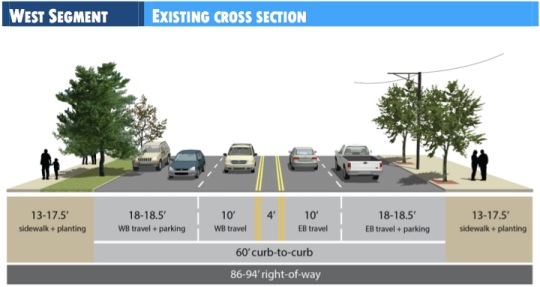
Here is the existing cross section:
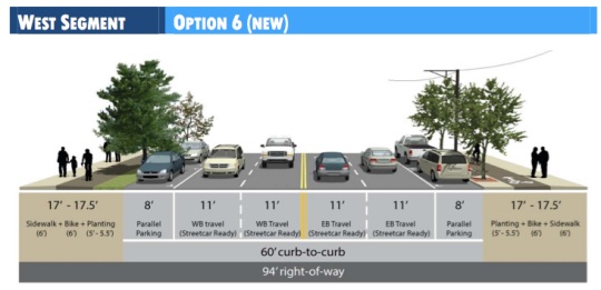
And a new Option 6 would have a six-foot bikeway on the existing sidewalk.
Option 7 would have traditional, six-foot, non-buffered bike lanes.
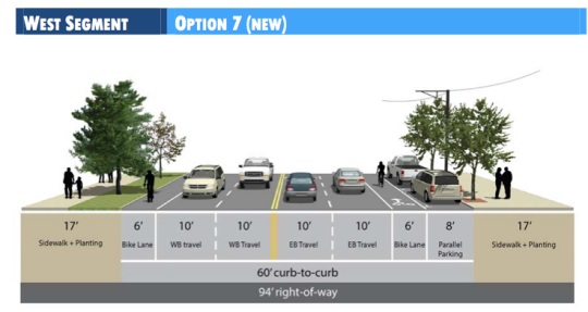
These two options don’t favor bikes as much as options 4 and 5 do, both of which call for a cycle track (we shared those designs last month). Also worth noting in these new options are the ten-foot lanes. City buses are 10.5 feet from mirror to mirror, which could make the 6 foot non-buffered bike lane feel that much smaller when buses are near. A possible future streetcar line will likely also need 11 foot travel lanes, if plans for that move forward. All this is not to mention the political strain of using 10-foot vehicle lanes. Sources tell us TriMet has been pushing back on 10-foot lanes whenever PBOT considers them.
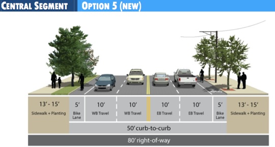
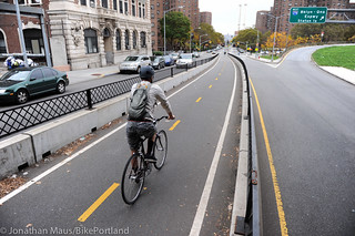
As for the Central Segment (SE 72nd to SE 80th), a new option presented that would have standard, five-foot bike lanes:
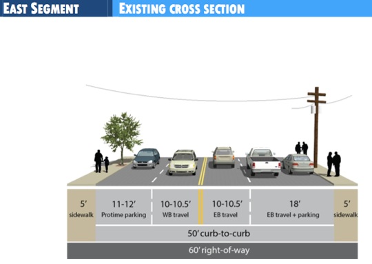
The East Segment (SE 84th to the Couplet) had one new option presented. Below is what it looks like today…
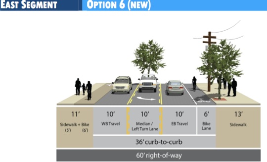
And the new option would have a six-foot bike lane eastbound and a six-foot, raised bikeway westbound:
PBOT staff also proposed a “Green Link” concept, which got mixed reviews from the SAC. The new proposal would create something of a commercial district bounded by Laurelwood Park on SE 63rd, and the Firland Parkway on SE 72nd. The use of more distinct street light and different trees would establish a a more defined “Foster district”. Cost concerns were voiced, particularly whether it would be funded by the City, through grants, or by business owners. But those questions weren’t addressed, as these plans are too far out to discuss funding.
City staff had much to report in last night’s meeting, including pending installation of safety beacons due to hit Foster soon. The first of the four safety beacons, which are being installed in a separate project from the Foster redesign, will be installed next Tuesday.
Also discussed was a potential $2.5 million grant PBOT has applied for to install a transit island on 50th and Foster to help slow traffic and ease transit use at the busy intersection.
Having biked on Foster to the SAC meeting last night around 5:30 p.m., I can say all of these proposals are a huge improvement to the current adrenaline-inducing conditions. Given its diagonal orientation and the lack of connectivity on side streets, the prospect of improving access for bicycles on Foster is a big deal. But even beyond bikes, this planning process could make Foster a much nicer place to live, work, and visit in general. Stay tuned (another place to follow updates on this project is FosterUnited.org.)



Thanks for reading.
BikePortland has served this community with independent community journalism since 2005. We rely on subscriptions from readers like you to survive. Your financial support is vital in keeping this valuable resource alive and well.
Please subscribe today to strengthen and expand our work.
I’m not really understanding this statement: “These two options don’t favor bikes as much as options 4 and 5 do, both of which call for a cycle track (we shared those designs last month”
Option 6 does have a cycletrack. And we can debate all day and night about whether cycletracks or regular old bike lanes “favor bikes” more.
Personally (and I was at the meeting). I think the idea of a cycletrack on Foster is a bad idea. It’s a street with a ton of cross streets at weird angles, and these proposals are now looking to “shield” cyclists from the road by making the invisible behind parked cars AND trees. Not to mention the burgeoning sidewalk seating of a few of the newer restaurants, and the fact that no separation from pedestrians guarantees conflicts. I think cycletracks have their place, but I don’t think Foster is one of those. I also don’t think cycletracks on foster (esp. if the road is left with 4 travel lanes) are going to encourage more people to ride on Foster). Families and the “interested but concerned” groups are still going to avoid Foster.
All in all though, I feel really good about things moving forward!
where do you believe cycle tracks belong if not on an arterial that cuts diagonally through a large swath of SE pdx towards downtown? imo, foster is the epitome of a road that needs both a road diet and increased space for cyclists.
the planting area should be removed and there should be increased separation between cyclists and peds.
I think there’s some confusion about how and why road diets are applied. The purpose of a road diet is not to decrease or discourage automobile use. The purpose of a road diet is to right-size facilities that are over-built. That is why they’re really only recommended for roads that have less than 20K average daily trips, and show the best results on roads with less than 15k.
Folks that are advocating for a road diet to decrease traffic for the purposes of discouraging automobiles on the roadway are not doing any favors to folks that support road diets. We need to be advocating for the right application of tools. The benefits of a road diet on Foster are highly questionable because the ADT is in the 23-24K range, and even reaches 29k in some segments. Nobody should be getting attached to the idea of a road diet until there is evidence, from the models, that it will actually help.
Interesting stuff. What have been the trends in car traffic on Foster over the past decade?
Good question.
There was a plan in 1999 for the area of Foster in Lents called the “Foster-Woodstock Streetscape Plan”. At 88th Ave, the count in 1999 was recorded as 26,950 ADT.
At the time, the transportation planners modeled (aka. guessed) that in 2015, the volumes would be 34,700 ADT.
We’re not quite to 2015 yet, but the planners went out and measured the volumes here again as part of the new plan. The result: 23,057 ADT.
Not only is this far, far lower than the original model predicted, it is 14.5% LOWER than it was in 1999.
Honestly, I don’t know how to read this. Have we reached peak driving on Foster? Residents of the area say that volumes feel like they have gone up since 1999, even though the data seems to disagree. Also, changes in volume at this location may not be representative of volumes farther west.
I have a question about this issue out to the planners on the project.
Maybe the 1999 plan underestimated the effects of the Green Line?
I believe we’re seeing two effects:
-The high modeled 2015 number is likely due to significantly under performing residential growth in Happy Valley and Damascus. Metro officially acknowledge this within the last couple years and has said they will adjust their model to compensate. However, the current news about Damascus disincorporating might throw a wrench into their revised numbers.
– It is generally accepted that the recession has had a lowering effect on travel demand across the board, which help explains the lower number, but not completely. I really can’t figure out why the volumes are so much lower today.
The city reps. claimed their models predict increased traffic over the next 10-20 years (due to increases in Clackamas county development I’m guessing), but there were some in the audience who verbally questioned that.
It is questionable that places like Damascus will generate the amount of traffic that the old (hopefully not the recently updated) models predicted. However, development in Pleasant Valley and areas immediately to the East is likely to continue and increase when the market for new housing rebounds.
Here’s a very interesting discussion of traffic projections and the degree to which those who calculate these are impervious to evidence that shows traffic volumes decreasing. It is very disheartening.
http://www.strongtowns.org/journal/2012/7/23/the-projections-fallacy.html
The accuracy of models is really a separate discussion from the actual project implementation. We have to use the models, we’re required to by policy and statute.
The long term solution is to come up with more accurate models or better methods of predicting the future. That’s not going to be done in the context of a streetscape plan that is going to be implemented in 2014-15.
Sure, but rolling our eyes and just going with the flawed assumptions built into models is no solution either. If it is half as bad as that article makes it out to be I’d say it’s time for some bureaucratic civil disobedience.
“The benefits of a road diet on Foster are highly questionable because the ADT is in the 23-24K range”
I disagree vehemently. Vancouver BC made a historic decision to not expand its arterial system further and has seen real tangible benefits in livability and density. This is a story that has been repeated again and again in ageing cities all over the world.
“advocating for a road diet to decrease traffic for the purposes of discouraging automobiles on the roadway are not doing any favors to folks that support road diets”
i am not even sure what that statement is trying to say. imo, foster (and its obscene level of pedestrian carnage) is a perfect example of how not to build a livable and safe community. i want to see foster, sandy, and 82nd tamed because they are dangerous facilities that, imo, make our city less livable.
But what you’re advocating here is to not just “not expand its arterial system further” but to REDUCE its arterial system.
I bike commute every day and ride a lot, but I also occasionally drive, as do most on this blog (I would guess). To say that there should be no 4 lane arterials in Portland is kind of crazy. We need arterials, and we have scarce ones already.
That said, I am in support of reducing Foster to 3 lanes. But I wouldn’t begin to think about reducing 39th or 82nd to 2-3 lanes.
Perhaps, and I’m going to take a lot of flack for this, but perhaps our arterials need to be widened, in order to accommodate much wider sidewalks (compare Portland and Seattle pedestrian facilities on major arterials (excluding Aurora)), cycle tracks/bike lanes, and auto lanes.
At the same time, one solution to enhance safety o major arterials would be to reduce the # of intersections along them that cause conflicts.
I think that West Burnside is a great example of a successful street, although I think they could have removed one extra lane.
82nd is a city arterial pretending to be a freeway. given its proximity to 205 it is a perfect candidate for lane reduction. removing one of its *5* lanes and building facilities that calm traffic and increase safety seems like a very good idea to me. cesar chavez becomes a one lane road at the roundabout and there are no riots. chavez is hell for cyclists and even worse for pedestrians.
Is it worse than Foster? It’s still significantly narrower.
Like it or not 80-something percent of the city gets around in cars (even more if you count occasional trips), and getting rid of all 4 lane roads in Portland is a recipe for immediate disaster.
Are you honestly trying to ride on 39th or 82nd? Personally I’m okay with there being a few streets in town that just really aren’t bike-able. It’s not like in the SW where there are literally no alternatives to major streets. On the east side we have a variety of routes to choose from.
(and actually 39th continues as four lanes until Sandy).
Again, for me the bigger issue is the crazy width of Foster, and the in continuity of cars parked on the road, slight curves, changing lanes, and just general chaos when driving down the street.
Being militantly anti-car is not really going to get us anywhere, especially in debates like the one we are having about Foster. I’m definitely learning this by attending the SAC meetings and trying to understand all the differences of opinions in the room.
i ride 39th often. it is, for me, the quickest and most efficient route to get from point A (hawthorne area) to point B (hollywood).
but i can agree that a lane reduction may not be the only goof solution for the problem of cesar chavez. i still think 82nd is a very good candidate for lane reduction.
i am militant about safe streets. i think the belief that someone who does not share your priorities is extreme or fanatical is a perfect example of an overton window phenomena.
And I think sometimes really caring about safe streets is realizing that you need to pick your battles, and not just demanding that you have cycling access under EVERY circumstance. You have to be realistic.
And I think you are being extreme, in that you’re not recognizing or appreciating those (sadly the majority of people in the US) who want auto access. You don’t seem to be recognizing their priorities.
And roads can be calmed without road diets. Lane reductions are one tool out of many. Being evangelical about one particular tool as some sort of silver bullet, without demonstrating the benefit in the specific application in question, quantitatively, is not constructive.
In fact, the most useful tool – regardless of the number of lanes- for Foster is curb extensions. They shorten the crossings and get pedestrians out into the sight-lines of passing motorists before the pedestrians enter the roadway.
“The purpose of a road diet is not to decrease or discourage automobile use.”
These kind of black and white statements of opinion make conversation difficult. A desire for a safer traffic environment was the main rationale for many of the “road diets” that were installed in urban cities in europe.
“Folks that are advocating for a road diet to decrease traffic for the purposes of discouraging automobiles on the roadway are not doing any”
You are *ASSUMING* that this is my point of view. My primary motivation is safety and livability. Many of the accidents, injuries, and deaths on 82nd, Foster, and similar outer PDX streets could have been prevented if those arterial looked more like the fancy arterials in wealthy inner PDX.
I think cyclectracks should be on straight roads with minimal cross streets/intersections (lower density of traffic helps too). Look at the few we have in Portland:
Broadway- has very few car cross streets (being next to PSU)
SW Moody- No cross streets, and lighter traffic
Cully- Lower traffic road
Those all make sense to me. Putting a cycle track on Foster, where cyclists would pretty much have to come to a stop EVERY intersection to prevent from being turned into by cars does not make much sense. (they talked about possibly bringing the cycletrack “out” to mix with turning cars at each intersection, but that seems like it defeats the purpose of a cycletrack.)
Personally I would feel safer in a bike lane, where at least I know most cars can see me (hopefully), versus a cycletrack where I’m popping out of nowhere (from a tree-covered sidewalk) EVERY block.
You’re absolutely right that fewer intersections and obstructions are best for cycle tracks, but applying your standard to Portland would essentially lead to no cycle tracks being built. Here are a couple things to consider:
– For much of Foster, parking is only present on one side.
– Parking would be restricted in advance of intersections, so bicyclists aren’t just ‘popping out’.
– Because of Foster is diagonal, intersection spacing is actually longer than it is on most of Portland’s streets.
And, the big one: People bicycle on the sidewalk today. A properly designed cycle track will consider the needs of bicyclists in a way that sidewalk riding does not. If you look at other big arterials with bike lanes, people still ride on sidewalks.
Cycle tracks are the way to get people off sidewalks and into the street, where they are safer.
“Cycle tracks are the way to get people off sidewalks and into the street, where they are safer.”
But cycle tracks are sidewalks, even in the cross-sections shown for this story. They are a way to force cyclists off of the street, where many motorists think they belong, and where they are arguably less safe due to invisibility at intersections.
So what are your thoughts on the tree planter strips? Because I would definitely see those blocking motorists views of a cycle track. Almost makes more sense to put those in between the sidewalk and cycle track as a natural buffer.
Thanks for your hard work on this.
I’m not trying to be argumentative, I just have serious reservations about the cycle track options, and worry that in practice, they might not be that much more of an upgrade from what we already have on Foster. But on the other hand maybe Foster is a great place to experiment with these?
“Almost makes more sense to put [the tree planter strips] in between the sidewalk and cycle track as a natural buffer.”
I’m no fan of sucky cycle tracks, but this would be a better arrangement, IMO.
Sorry El B. I think I somehow hijacked your username? Why does this site seem to do that?
I don’t think so, I just replied to your comment agreeing that putting the planting in between peds and cyclists makes more sense than putting peds and cyclists immediately adjacent to each other.
traffic speeds are too high on foster for most riders to be comfortable being a few feet from traffic. maybe if they worked on really calming traffic.
Thanks for continuing to cover this, and thanks to everyone working hard on it! The new option (“6”) looks great. I also have my doubts about cycletracks in general. I’ve been run over in a right hook crash, and playing peekaboo behind parked cars seems like it increases the risk of those frequently fatal crashes.
A proper cycle track gives both drivers and cyclists much more time to react to possible collisions, and provides better sightlines from the driver’s perspective. The separation is what makes this work, unlike standard bike lanes which give the cyclists a millisecond to react to a right hook.
Also, minor uncontrolled intersections should have the cycle track and sidewalk continue through, grade-separated, so the cars physically have to slow down and drive up and over them. This is how they’re designed in the Netherlands and it really works quite well.
getting rid of parking, signalization, or channelization should be a requirement for a cycletrack.
if a bus is 10.5′ then lanes should be no smaller than 12.5′ in order to accommodate them… seems that a 10′ lane on a bus route forces the bus driver to do something illegal (drive in both lanes at the same time)… we already let them get away with many illegal maneuvers so we shouldn’t force more on them in a new design…
if a bus is 10.5′
Trimet buses are 102 inches wide (8.5′, 8′-6″). So are semi trailers. Mirrors extend past that. Ten foot lanes are tight but adequate (e.g. St. Johns Bridge).
http://en.wikipedia.org/wiki/Flxible_Metro
http://en.wikipedia.org/wiki/Gillig_Low_Floor
they need to get past the idea of four automobile travel lanes… if they want a vibrant and attractive street for businesses to flourish on then they need to get rid of two of the motor-vehicle lanes and give them up to bikes…
No option that leaves Foster at 4 lanes is acceptable from a pedestrian safety standpoint. So long as the street remains built like a freeway, drivers will continue to treat it like one. For me, lane reduction is the primary concern for both ped and bike safety.
agreed. every major arterial in pdx should be put on a road diet.
I was overly enthusiastic and am changing my “every” to “many”.
What is your opinion on four lane roads (arterials) without parking on both sides? To me that is one of the big problems with Foster, it is just a hugely wide road. Compare it to 82nd or 39th, which seem more manageable from a pedestrian standpoint.
Nice door zone in Option 7 eastbound, especially when you get a 10.5′ bus encroaching into the bike lane from the other side. Moving the bikeway to alongside the sidewalk is going to be the only option, unless they want to give up parking or a traffic lane.
PBOT is busy analyzing the impacts of both a lane reduction and parking reduction on Foster. Once we know the likely impacts, there will be a hard discussion about the benefits and costs of various proposals.
Most people on the Advisory Committee are happy with the idea of a 3-lane conversion, assuming it doesn’t wreck traffic completely. The primary fear of causing congestion is with added travel delay and concern over traffic diversion through residential streets.
The representative from the Lents neighborhood is very unconvinced that Foster will work with fewer than four lanes. We’ll see how he responds to the results of the traffic analysis.
“…assuming it doesn’t wreck traffic completely”
I assume you mean ‘car’ traffic? Because three lanes would seem to be an unmitigated boon for bike traffic, so perhaps we/PBOT should be including plausible effects on bike traffic too. If they are, great. It just wasn’t clear from your phrasing.
Apologies. Yes, car traffic. I believe that most of the Advisory Committee recognizes the negative cost such a high volume and speed of auto traffic has had on the neighborhoods, and sees the potential benefit to gain from accommodating bicyclists on the main street.
I’m sure that many of them are willing to put up with some level of added auto delay if it means we can get an awesome bikeway.
Yay option 6 for the West segment! It really does cram everything in that everyone wants in an elegant way. One thing that will need to be addressed is ensuring that we get those curb extensions in at every intersection in the commercial nodes, at a minimum. That will work wonders in decreasing the crossing distances and making pedestrians visible before they enter the roadway. For conflicts with cafe seating – there’s always the new Street seats program, or in some situations the businesses could choose to shift the cycle track into the parking zone (as a grade separated facility) and give up the parking spots in front of their business in exchange. Personally, I think the street seats is a more flexible plan because it can be folded up when the seasonal bike traffic fades away.
I think the cycletrack could work if it is continued through minor intersections – as in those cross streets would have a speed bump at the ends. something like cully seems like it doesn’t go far enough
I love Option 6 for the West segment. I am an “interested but concerned” biker who lives with a regular bike commuter. Neither of us would ride Foster if the bike lanes are non-buffered and the street remains four lanes. I would feel safe enough with this configuration that I could see myself becoming a much more regular biker – perhaps even commuting more often as it would be a much more direct route than I currently use. (This would mean one less driver on Foster on those days, as well.)
The added bonus of Option 6 is that you’ll rarely, if never, encounter freight vehicles at Rollaway, George Moral, Mt Scott Fuel etc blocking the bicycle lane.
I think it’s also exciting because we could do Copenhagen style intersections for bikes parallel to the crosswalks. It would be great to see big green trapezoids at every intersection and people making Copenhagen lefts.
But option 6 does nothing to reduce the width of the road. And frankly I almost seeing it being worse for pedestrians, as now they have less sidewalk, and bikes are suddenly right next to them, AND nothing has been done to help them cross the street more safely (excluding some of the new crossing signals).
These are mid block cross sections. The crossing widths can easily be reduced with curb extensions at the intersections. That will remove 16 feet of crossing distance at a minimum in most cases and move the pedestrians into the area where they are obviously visible to cars.
Crossing 4 11 ft lanes is not difficult. Just to put it in perspective, that’s like crossing SW Broadway at Madison.
At signalized crossings, like Broadway and Madison, crossing 4 lanes is no trouble. But at 70th & Foster, where there is nothing to help you across, 4 lanes is literally deadly. (it’s deadly for pedestrians, and deadly for neighborhood serving retail).
Hawthorne comes closest to having a walkable 4-lane street. They do this with three things:
-Substandard lane widths (9.5 feet!)
-Traffic signals every two blocks
-Well marked crosswalks on all other blocks.
If 4-lanes stay on Foster, then I’m going to advocate to reproduce the Hawthorne conditions to the highest extent possible.
I agree, we definitely should be aiming at replicating the curb extensions and frequency of crossing opportunities. The substandard lanes would preclude streetcar – and preserving transit right of way (for buses and hct) is a goal, adopted by consensus, for the project.
Hawthorne doesn’t have 2 block spacing of signals along it’s whole length. It’s only like that at the commercial nodes. That’s definitely feasible for Foster. The node at 65th already has two block signal spacing between 60th and 67th. The area around 56th would need maybe one signal, and around 72nd, maybe one more. But that can be phased in.
I might be wrong, but haven’t at least a few of the deaths recently on Foster occurred when the pedestrians were crossing mid-block. Yes, we can put in curb extensions at intersections, but that doesn’t mean that people are guaranteed to use them.
There’s really no incentive not to cross mid block now – the crossing length is the same distance. The only real advantage to walking to the corner is a statutory advantage. Curb extensions do have a visible incentive for walking the extra 40 feet, particularly if they’re well lit. You can see that it will be easier to cross and that cars will have an easier time seeing you.
Whatever configuration is decided upon it should only have three lanes (two travel and one for turns) and the travel lane should be at least 11 foot wide to accommodate buses and a possible future streetcar. Also, I live on a street with “pro-tem parking” that flips during the commutes…and it is AWFUL and leads to accidents all the time. This should be avoided at all costs….
Either a nicely constructed cycletrack or a protected bike lane would work, and I personally would use either one, but it is important to get a design that can be easily upgraded in the future without major redesign if higher capacity transit does manage to come that far out east, plus buses HATE 10 foot lanes….and to be perfectly honest as a driver I do as well. I will not drive on Hawthorne unless absolutely needed because the lanes are too narrow for me to be comfortable…narrow lanes may work to slow traffic down, but we should avoid this for Foster.
But when the cycled track pretty much is the sidewalk you’re not really getting them off the sidewalk? And it seems like the city has abandoned a PSU like cycle track (where the track is at street level with a buffer from parked cars) due to the cost of moving the curb.
That is why I asked the question at the SAC meeting about the cycle track being a lower grade. (I know it was a little premature).
I guess that’s my underlying issue, that this cycle track (at least how it is laid out in these figures) is essentially just putting bikes on the sidewalk.
(Sorry for the proliferation of too many posts, I’ll try to keep it under control).
But, in this case, the sidewalk right of way is 17 to 17.5 feet wide. That’s a lot of space. For comparison, the cycle track on Moody has about the same allocations of space. There’s 6 ft of pedestrian area and 5-6 feet for planting. The cycle track has wider lanes for bikes but it’s two way. In the case of Foster, the lanes are on either side of the road so they can be slightly more narrow.
I like the option of moving the cycle track onto the side walk – and I apologize if I to pedestrians – but in my experience the pedestrian use of Foster is low enough to facilitate a side-by-side with appropriate warning signs. It doesn’t solve the problem of traffic calming, but would make riding on foster much nice and use what is already there!
But this streetscape plan is trying to plan for and shape what Foster looks like for the next 20 years. We want to get more pedestrians on Foster (due to increased restaurants/shops etc.).
Basing a plan on what the current use of Foster is will get us into some hot water. By that logic we almost shouldn’t put bike facilities in because so few people bike on Foster.
why no two way cycle track option?
they are very common in europe and even our neighbor to the north is doing them:
http://spacingvancouver.ca/2011/07/25/vancouvers-hornby-and-dunsmuir-separated-bike-lanes/
That is what we should have built on outer Sandy instead of the standard, but wider, bike lanes….and follow the tracks all the way west (on the south side of the street with access at each light heading northbound) via Lombard and Columbia all the way to the to Industrial Zone past Saint John’s. I think it would work on Foster also, but could be more difficult because of the diagonal nature and the want to have access on both sides of the Foster. Madison, Wisconsin has one of these on University Avenue that I used constantly in the 1990’s and it worked wonderfully.
Two way cycle tracks are not very appropriate on two-way streets. You’ll notice that the Vancouver BC, Chicago and NYC examples of two-way cycle tracks are all on one-way streets.
It’s not impossible to do, but it is much more complicated. For all of the reasons people oppose one-way tracks, two way tracks will be opposed even more.
It could work if, instead of the usual treatment, the cycle track was put in a median down the middle of Foster. This is the ‘standard’ when considering rapid movement for buses or trains. Why not Bike Rapid Transit? A center median cycle track would also practically eliminate left hooks while providing a median for pedestrians to cross at. And if you think it won’t work for motorists, you only have to look to Interstated or E Burnside to see how to handle left turns.
I’d like to second this. We should really try this on a busy street in the metro area. I liked the middle running bike lanes in Washington, DC a lot. No bus/right hook problems. Of course you have to have signalized crossing turns, but Foster needs those for pedestrians anyways.
It definitely can work… That’s what NYC DOT did on one of the approaches to the Manhattan Bridge
“As for the Central Segment (SE 72nd to SE 80th), a new option presented that would have standard, five-foot bike lanes”
But above it says the Central Segment is SE 52nd to 72nd. Typo?
PDC is asking people to share their priorities for improving Foster: http://www.pdc.us/our-work/urban-renewal-areas/lents/current-projects/flip/flip-forum.aspx
Please keep in mind that this prioritization exercise is for the entire Foster Corridor between 50th and 122nd and involves much more than the streetscape. It is also supposed to address ongoing economic development – including industrial development not just mom & pop shops, parks, storm water/ flood storage infrastructure and habitat connectivity, as well as other EcoDistrict scale projects like district energy etc. It is about the investment priorities of 4 bureaus (PDC, BES, Parks, and PBOT)
The theoretical money is not just about the money budgeted for the streetscape, but for all investments made between 50th and 122nd over the next 5 years (which there is much additional money for, depending on the project).
So, if you do go to the survey, please don’t skew the results by being mono-centric about your priorities. Please try to be holistic and supportive of the entire corridor.
“please don’t skew the results by being mono-centric about your priorities”
one does not skew a democratic process by voicing a preference. for example, i have a mono-centric opinion about the PDC: it should be shut down immediately.
I think Cora is just trying to remind people that that length of Foster (50th to 122nd) is a long section of road with diverse interests (transportation, commercial, residential, development, etc.), and that singular solutions are not going to very helpful.
For example, do you think that all money should be spent on bike infrastructure at the expense of parks? It really requires a balance.
A perfect example is the above process, where most people recognize the fact that Foster between 52nd and 90th is a varying road, thus we are looking at different streetscape solutions for each section separately.
when it comes to high-speed pseudo-freeways like foster and 82nd i am far more concerned about pedestrians like lindsay leonard and margarito gutierrez than i am about cyclists.
I found the link on the Oregonian web site. No one told them not to skew things in favor of raising the speed limit and taking out the sidewalks. So.
I found the link on the Oregonian web site. No one “warned” them not to skew things in favor of raising the speed limit and taking out the sidewalks. Everyone is allowed to have their own priorities — that is the point of the survey, and I posted the link here because I like the priorities of BikePortland readers. If you have a curb extension blog you like to follow (curb extensions — yuck! do you even ride a bike?), I encourage you to post the link there as well.