(Image: Google Street View)
After our report last month about the Oregon Department of Transportation’s new “ORcycle” app for reporting biking problems, BikePortland reader Hazel G. decided to try it out.
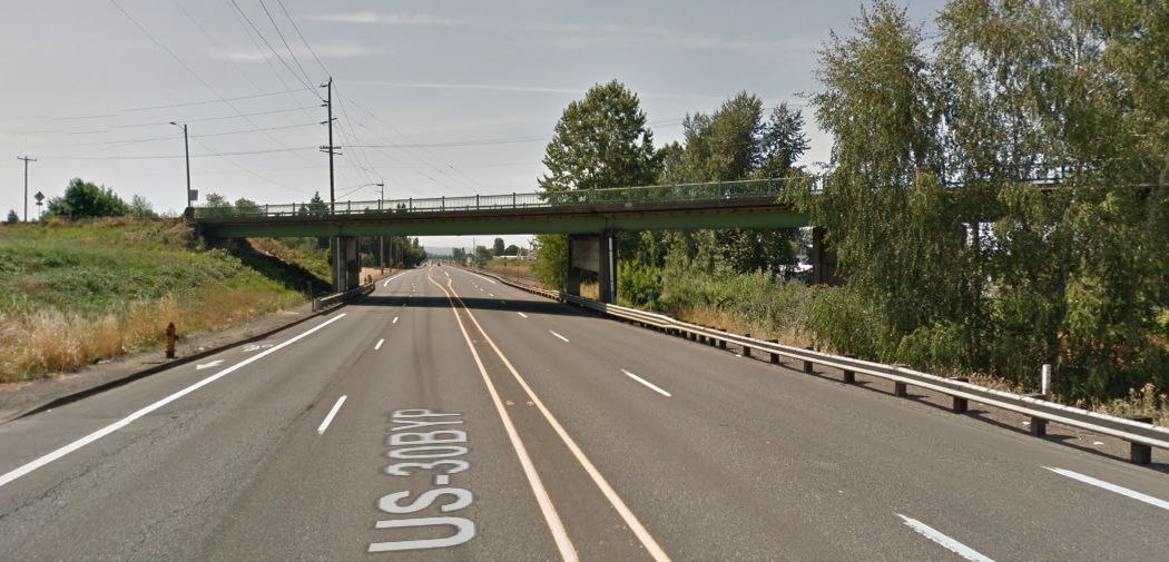
Hazel regularly bikes on NE Lombard Street, a U.S. highway managed by the state, under the overpass of 42nd Avenue. This is one of those overpasses where it suddenly becomes less important to separate people biking from 50 mph motor traffic than to ensure that both lanes of motor traffic don’t have to merge into a single lane. (This is a strange American approach to street design that we compared with European practices in 2013.)
“Super scary spot to ask bikes to mingle with cars and freight going 50+ mph,” Hazel G. said in an email. “The bike lane vanishes and there are signs warning that bikes are in the roadway. I pretty always just stop and wait until there is no traffic.”
So Hazel fired up her free ORcycle app to see what would happen if she told the state about this problem. A few weeks later, she got an initial email saying that her issue had been received and that she’d get a second email in a week or so after that. About week later, she got this email (emphases mine):
Thank you for bringing this bike lane gap to our attention. This section of Lombard was not previously coded as a gap in our bicycle facility inventory. I have asked our Asset Management Unit to correct this information so that this segment will be shown as a deficiency when we scope future projects in the area.
“There is not extra pavement width that could be reallocated to stripe bike lanes.”
— ODOTOn this segment of Lombard, the 42nd Ave Bridge creates a pinch point that results in the elimination of the shoulder/bike lane for approximately 350 feet westbound and 200 feet eastbound. Warning signs indicating the bike lane ends with a bikes “in roadway” rider sign are provided in both directions, per ODOT standards, to warn people driving and biking of the changing conditions. Unfortunately, the travel lanes and median have already been narrowed to fit under the bridge, so there is not extra pavement width that could be reallocated to stripe bike lanes. The location of the bridge supports and steep grade to the railroad tracks to the north also make widening the roadway to accommodate standard bike lanes very difficult and expensive, especially if constructed as a standalone project.
Most sidewalk and bike lane infill projects on ODOT highways are funded through the Sidewalks with Preservation (SWIP) program. We try to leverage SWIP funded improvements with other projects (e.g. repaving) in order to reduce design and construction costs, minimize construction impacts, and maximize what we can accomplish with limited funds. In conjunction with a future project, we may be able to construct curb ramps and pave a narrow path behind the guard rail and bridge supports to provide a separated route under the bridge for people biking. A pavement preservation project on Lombard (US30 Bypass) from MLK Blvd to 60th Ave was recently proposed for funding through the 2019-2021 State Transportation Improvement Program (STIP), but unfortunately was not selected for funding. It will likely be on the list for consideration again when we program the next round of STIP projects. I spoke with the City of Portland Bridge Unit, who owns and maintains the 42nd Ave structure, but they do not have any improvements planned to this structure in the coming years.
Thanks again for reporting this issue and please let me know if you have any additional questions.
Advertisement
Here’s Hazel’s summary of their further exchange:
I let her know that I was aware that there were bikes in roadway signs but asked if she would feel comfortable hoping that drivers would be courteous here since getting hit at 50+ mph would most certainly result in death. Her response was to alert me to better routes to take. Which I’m aware of but Lombard is the absolute fastest east west route in this part of town. I think this road is often ignored as one that even has a bike lane east of MLK. Getting this response also makes me want to ask why bother having a bike lane if you then acknowledge that part of it is incredibly unsafe?
Sorry for the rant. I’m amazed to have gotten a response at all but not really any solution. I’m also glad that I could bring this to their attention since it had managed to be overlooked in the past.
It’s nice to know that reporting on this app can have some small effect. But it’s also perfectly clear from this account that the other solution staring ODOT in the face — the possibility of forcing motor vehicle operators to merge with one another rather than with bicycle riders — is unthinkable to the agency.
According to the state’s online maps, Lombard carries between 20,000 to 30,000 motor vehicles a day on this stretch, almost all of which is probably through traffic. So a lot of travelers would be affected by a change, though it’d require traffic engineering to figure out if there’d actually be much delay.
But here’s the thing: in explaining to Hazel G. why the most efficient bike route through this area isn’t going to be made continuous, ODOT doesn’t consider the possibility of restriping to remove a passing lane. A convenient bike route through a city, connecting some of its bike-friendliest neighborhoods to some of its most important employment areas, is “extra” by definition. A lane that makes it easy to pass a truck in a car is not.
Prioritizing biking, apparently, isn’t even a possibility worth dismissing.
— Michael Andersen, (503) 333-7824 – michael@bikeportland.org


Thanks for reading.
BikePortland has served this community with independent community journalism since 2005. We rely on subscriptions from readers like you to survive. Your financial support is vital in keeping this valuable resource alive and well.
Please subscribe today to strengthen and expand our work.
Incredibly…the state responded with “we just can’t do anything” which pretty much says “you don’t drive a car…so good luck out there sport!”. It’s funny that they think there is nothing they could do when in fact any average person can see what can be done.
There is a sidewalk right there. Widen the sidewalk into the hillside, stripe for bikes and Peds and shore up the small retaining wall.
This is of course too small potatoes for odot…and no child has been run down. Also, odot could simoly restrict to one lane on one side. That takes paint.
Or..they could borrow the center painted medium to no more than a single painted line. This is done all the time.
Point is…lots of low cost solutions and yet we are celebrating a response email that cost odot nothing.
It’s good to point out their failures to that when someone dies or is maimed…a lawyer can discover through foia, and recover damages. Damages that would be in excess of the actual fix needed.
Maybe some paint on the road surface might help… Paint shy lines ahead of the overpass to encourage MOTORISTS to move away from becoming a hazard to bicyclists.
ODOT KNOWS
Oh, and as I’ll likely be in China by the middle of next week, you can’t count on me doing it.
Has anyone encountered a different result with the app yet?
I’m highly skeptical, but wondering if ODOT will use this app to actually make improvements, not just get back to us with, “Yep, that area does suck, deal with it.”
Anyone?
ODOT staffer Jessica Horning’s comments below are encouraging in at least some respects:
http://bikeportland.org/2015/12/11/scary-pinch-point-on-lombard-puts-new-orcycle-trouble-reporting-app-to-the-test-170071#comment-6600874
I recently sent a picture of cars using a bike lane in Hillsboro for parking rather than their driveway. They forwarded it to the correct department in Hillsboro and I have not seen a car parked there since. Only time will tell how well they will keep up with requests.
Thanks for the straight talk, Michael.
Actually, it looks like it would be relatively easy to add ramps on the south side allowing cyclists to use the existing sidewalk to get under the bridge. To the north, a fairly modest retaining wall would allow for the same movement. Also, does Lombard even need to be four lanes here? I can’t recall ever experiencing congestion while driving this stretch.
My best defenses to this lackadaisical engineering are my helmet rear view mirror and my brakes…punctuated with an occasional hand gesture.
I agree with Chris..
should be pretty easy to just have to bike lane go around the overpass supports with some retaining walls….
“…ODOT doesn’t consider the possibility of restriping to remove a passing lane. …” andersen/bikeportland
The dept may have made such a consideration. First asking whether it has, rather than presuming the dept hasn’t made such a consideration, seems like the more responsible course of action.
“…In conjunction with a future project, we may be able to construct curb ramps and pave a narrow path behind the guard rail and bridge supports to provide a separated route under the bridge for people biking. …” ODOT spokesperson
I like this idea, and looking at the google street view picture, it seems doable. Looks like that with some retaining wall, there easily could be room for at least a 6′ wide path. Have to wonder though, how much it would cost to do that. Anyone interested in taking a guess? $500,000 to a million, I suppose.
Okay, so then with that cost basis to compare to, a ‘two to one’ lane reduction road diet seems likely to be lower cost. All other dynamic traffic factors considered, would this provide for safe road use? Likely a likely a little safer for people biking. Not as good though, I would think, as having the bike lane routed around the bridge supports.
The full quote of course is “in explaining to Hazel G. why the most efficient bike route through this area isn’t going to be made continuous, ODOT doesn’t consider the possibility of restriping to remove a passing lane.”
That full quote of course is 100% accurate: In ODOT’s response to Hazel they didn’t acknowledge it as a consideration.
“…In ODOT’s response to Hazel they didn’t acknowledge it as a consideration.” mick o
That’s why I suggested it may have been better before presuming, to ask ODOT to clarify. If the dept has made such a consideration, a reference to that probably should have been included in letter to Hazel. Having done that would likely have at least altered somewhat, the way the discussion to this story has proceeded. I’d like to think, in a more productive way. Letter responses can have a lot of bases to cover. Hopefully, not having mentioned a road diet in the letter to Hazel, was just an oversight on the part of the ODOT spokesperson.
I’ve got the feeling that a lot of bikeportland readers would like ODOT to just go out to this location ASAP, within days rather than weeks and months, and reconfigure this road point for a road diet to enable the bike lane to continue under the overpass. People reading here with ideas and understanding of a specific form such a configuration would need to take for safety and functionality, ought to go right ahead and propose them here: how wide a bike lane to provide for…how many feet in advance….100’…150′, etc of the lane merge, should the ‘two to one’ transition commence.
“I’ve got the feeling that a lot of bikeportland readers would like ODOT to just go out to this location ASAP, within days rather than weeks and months, and reconfigure this road point for a road diet to enable the bike lane to continue under the overpass.”
I’m not so sure we’re as clueless and wishful as you make us out to be. What I’ve long objected to with ODOT is an evident PATTERN of casual disregard, of other priorities, that only get upset when someone’s leg is ripped off (e.g., 26th & Powell). And note that in that case we got a turn signal whereas when Amanda Fritz’s husband was killed by someone crossing the median on I-5 NorthEast of Salem, Garrett promptly found I think it was $5million to install a cable barrier for miles….
“…I’m not so sure we’re as clueless and wishful as you make us out to be. …” watts
Knock it off watts…that kind of insulting is just not called for in response to the comments I’ve posted here. Please try and keep your remarks substantive and to the situation referred to.
Some people reading about road situations like this one, feeling that with a reconfiguration of the main lanes of travel, may possibly become somewhat safer to use by vulnerable road users traveling by bike, should give thought to what they understand could be the specifics required to make the configuration. I may have some ideas of my own about this, but rather than posting them straight away, I’d rather first read some of what other people think about what form the configuration should need to take.
And now, as of last night, a fatal collisions has taken place at the road point this story has as its subject. In light of that occurrence, the reason for it at this time, still remaining somewhat of a mystery, more people, and not just those working for ODOT, really need to be giving much more serious consideration to just what form adaptive active transportation infrastructure should be taking.
They added similar signs along INterstate Ave just before the Larrabee overpass. Cars travel much slower here, 35-40 mph, but they either do not see the signs, do not care about the signs, or do not believe the signs indicates that they have to do anything to accommodate a person ona a bike trying to merge into their lane before the bridge. I cannot imagine trying this merge on Lombard!
I use the app daily, tedious as it is. I report EVERY close call in the vein the “nearlykilledme” database, and bike lane debris. I was mildly surprised that SW Vista was swept this week after some horrible weather days. I think if every person commenting here on BP reported close calls, infrastructure gaps, and crashes, ODOT would no longer be able to put their collective head in the sand in regards to vulnerable road users. They have NO data. They need us to provide it to them.
Look no further than this response by ODOT when one of us here suggests that to ODOT bicycling is a second class activity. Not impressed.
ODOT exhibited the same lack of imagination when it came to the two bridges on Barbur. I crawled under the bridges and came up with several fairly straightforward solutions for how to widen the sidewalk/reinforce it/etc. that ODOT said were not possible (detailed in an older discussion here).
I strongly suspect that it never occurs to anyone at ODOT that coming across as callously disinterested and unimaginative when bikes or people walking raise concerns could be a problem (for them, not just for us).
The callousness seems to be “Why would you be upset to be told that doing your recreation somewhere safer would probably be a good idea?” That is, biking is optional because gas is cheap.
ODOT has the money, the brainpower, and all but one tool: the sharp blade of motivation.
Like usual around here, it’s sheathed at the bottom of the toolbox. The handle is barely even worn.
That pinch-point is a big problem both directions and the south side becomes a large, dangerous puddle every time we get a big rain.
Also, that stretch of bike lane (heading east from 42nd to 60th) is regularly used as a parking lane by locals, in spite of the signs along the curb and bike symbols in the lane.
I’ve complained dozens of times and somehow, between the state and the city passing the buck to each other, nothing gets done.
Bike are practically in the gutter on the dirty 30. Why would ODOT suddenly care about a pinch point?
I agree. Route the bike lanes around the right side of the bridge supports, and add nighttime lighting under there, too. There could be other places where this idea could be used, space and ROW permitting.
why is this urban street under ODOT control? because they were too lazy to give it back to the city when they dug out Sullivan’s Gulch? it’s not a state highway anymore, it’s the bypass around the state highway…
the real highway 30 is a ways south…
GIVE THE CITY STREETS BACK TO THE CITY!
The reason is because it’s the overdimensional freight route. When someone has to move a giant over-sized load like a house or a boat hull, they have to take the US30 Bypass because the other routes don’t have the necessary vertical or horizontal clearance.
In the long-term, there is an idea to switch the over-dimensional route to Columbia Blvd, but right now there are a few overpasses that are too low and would have to be rebuilt.
In defense of the ORCycle pilot project…The ORCycle app has been forwarding reported bicycle safety concerns to agency staff for a couple of weeks now. This is one of a handful of reports I have responded to so far within the 5 day window ODOT staff are given to research a solution before getting back to the person who reported it. Most of these reports have resulted in sweeping, drain clearing, bike detection fixes, or other immediate improvements. This is one that unfortunately doesn’t seem to have an immediate solution that we can identify funding for, but it has resulted in ODOT taking a close look at the area and developing a game plan for resolving the issue (with a separated bikeway) in the future. I know that’s not a satisfying response for anyone who has to deal with this gap in the meantime – like I told Hazel, I take the slower Holman/Ainsworth greenway route instead – but I’d say it’s a pretty good return on investment for spending 2 minutes using an app to report an issue.
Please, use the app, support this pilot project, and help us collect better data on these issues.
They only give you 5 days?! PBOT staff are given 16 weeks to respond to 823-SAFE reports, due to the extremely high volume. As ORCycle gets more use I really hope they give you more time to respond. I would rather have a thorough investigation and response than have it be rushed.
The reason for 5 day responses are given in Jessica’s comment: most of the fixes are sweeping and drain clearing. Why would you want longer than 5 days to respond to a drain sweep or garbage/road hazard clearing? If it’s an engineering solution, such as at the 42nd overpass, they can send an email saying they are looking at fixes that require more time.
Additionally, I think one other important “success” of this request has been to put it on ODoTs radar…though I am a bit surprised they did not have the bike lane recorded in their file/ facility map.
And this dialogue is important, just as similar discussions (and education) occurred with City engineers in the 1980s/ 1990s as to “why” cyclists would want to bike on multilane arterials…now so such must be done with highway engineers. They sometimes forget or need to be reminded that cyclists choose to ride on highways for the same reasons motorists drive on them: level[er] routes, no friction from car doors or parking vehicles, access control (less chance of being hit by cross traffic), direct paths without traffic lights, and sometimes nice wider lanes (as in the case of a shoulder).
I have had similar chats in the past with WSDoT engineers about my bike riding on the shoulders of SR-14 and SR-500 …back when I worked for the City…and these routes often saved 25% of my travel time vs. more circuitous trails or hodgepodge City bike lane segments. They are used to serving (and expecting) cyclists needs on rural highways or urban arterials.
Yes!
Why not build a short section of bike path going around the outside of the support pier, on each side of the roadway? Appears to be plenty of room.
Let me guess, cost prohibitive, right?
ODOT: “Durrr… Oh wow. There’s a gap there?”
Kinda makes you think that we all need to do a thorough inventory of all these gaps and shove the list in their face because they can’t do their own #$&! JOB!
I was surprised we didn’t have this gap in our inventory too, since we just did a pretty thorough update last year: http://www.oregon.gov/ODOT/ATNI
There are just a few of these small (~100′) gaps that we seem to have missed (not bad out of 800+ miles of highway). If you come across a gap while you’re riding, please do “shove it in my face”, cause it does indeed help me do my job. You can use the ORCycle app, or email me at jessica.horning@odot.state.or.us
Are there any gaps for motorists? Would these possibly ever miss being inventoried and immediately remedied?
That’s what we mean when we say that ODOT treats active transportation as less than second class. It’s all relative.
Although not quite on the Lombard topic, I’d like to say that this article inspired me to download the ORCycle app and start reporting. Although I now live in MN I’m frequently in Oregon, including the present moment.
I reported 3 issues that I encountered last night riding from Beaverton to Portland:
– The obscenely narrow bike lane (21″! seriously!) in front of Key Bank on Beaverton-Hillsdale near Oleson, just outside the Portland city limit.
– Two cars parked in the Beaverton-Hillsdale bike lane at Martha St.
– Vehicle detector failing to “see” bikes, at the left turn from EB Capitol Hwy to NB Terwilliger.
All 3 issues are along a state highway, two requiring immediate attention. The first issue has been an ongoing problem for many years, then got slightly worse about 4 years ago when Key Bank moved in and rebuilt the sidewalk.
And then it became absurd 2 years ago when PBOT striped protected bike lanes along BHH from the city limit all the way to Hillsdale, highlighting that there’s plenty of ROW for a decent bike lane, if the agency in charge (ODOT) would only do it. The center two-way turn lane must be 18′ wide there. And although Five Corners mess itself doesn’t easily lend itself to a bike lane at the moment, there is room all the way from there to 217 with little more than paint/thermoplastic changes.
Like Lombard, this is a change that ODOT could make relatively easily if they start paying attention to making their corridors suitable for biking continuously rather than intermittently. I will post their response here.
Just a heads up that for parking violation you should call parking enforcement. As far as I can tell, the app isn’t designed to dispatch this info in a timely manner to the police department.
Simply asphalt over the existing dirt path and make the entrance obvious. Give cyclists a choice if they want to run the narrow asphalt or the lane gauntlet. You don’t need a 5 star facility…. Just a place to survive.
Well
..it’s happened.
http://bikeportland.org/2015/12/12/fatal-hit-and-run-on-north-lombard-at-ne-42nd-ave-170230
I had the same discussion with a (likewise responsive and courteous) ODOT rep recently about the handful of spots on SE 82nd where the sidewalk dead-ends into a private fence or building because ODOT has allocated the entire ROW to 4 lanes of traffic plus a center turn lane. Response was someday it would be great to buy private properties to widen the ROW to fix the sidewalk gaps.
Yeah, “someday.” CCR sang about that.