The Bureau of Planning and Sustainability has released a bold new vision for a “Green Loop” that would circumnavigate Portland’s urban core with world-class bikeways, walkways and parks. Other names suggested include “Promenade Park”, “The Park Way”, “Urban Trail”, “The Central Path”, “The Way Around”, and “Compass Park”. According to a document released last month as part of their ongoing West Quadrant Plan (PDF), the BPS study fleshes out an idea that was first introduced in the Central City 2035 Concept Plan.
existing “active transportation infrastructure”.
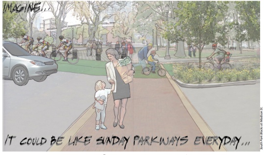
A drawing of the south park blocks on page two of the study (seen above) is accompanied by the words, “Imagine… It could be like Sunday Parkways everyday.” It depicts a public space full of people, plants, and dedicated space for bicycling and walking.
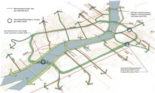
In the document, the loop concept is described as, “A 10-mile linear public open space that will strengthen the Central City’s role as the ‘Center for Innovation and Exchange’ over the next 25 years.” It’s being seen as the public space analog to the existing — and more commercially-oriented — central city streetcar loop. The route would utilize the Broadway Bridge, the north and south Park Blocks, and the Portland-Milwaukie Light Rail alignment (including the new bridge) through southwest Portland.
The six “key objectives” described in the concept plan include:
1) Improve Health
2) Connect Parks
3) Support Businesses
4) Increase Trails
5) Encourage Riding
6) Grow & Build Green
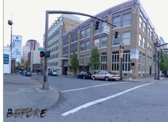
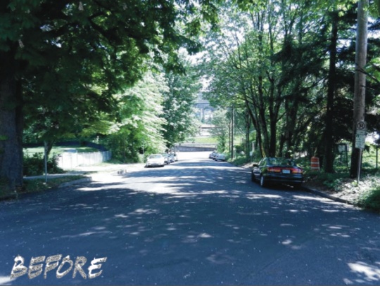
The concept document includes several tantalizing before/after images…
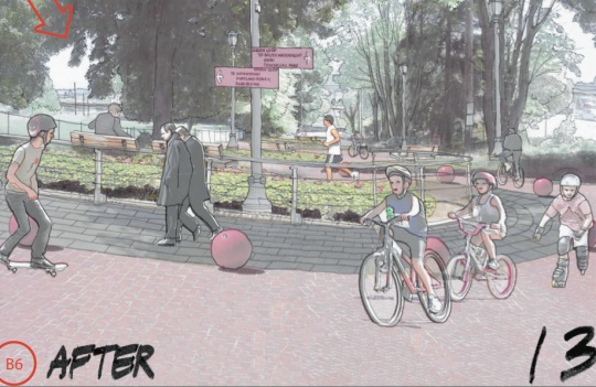
SW Salmon before (note the dedicated bicycling space in the upper right)…
SW Salmon after…

SW Caruthers (from Water to Naito) before…
SW Caruthers (from Water to Naito) after would “explore creation of Lombard like (in San Francisco) hill park…
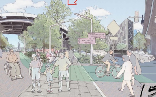
And the very annoying Naito Gap near the Steel Bridge before…
And after…
As inspiration for the idea, the BPS document includes references to the British Columbia Parkway in Canada, the Rio de Salon in Madrid, and the Indianapolis Cultural Trail.
While the vision is exciting enough on its own, it’s also important to note that it could be done on a tight budget. “The concept is a relatively low-cost opportunity in the face of dwindling resources for major infrastructure systems such as regional transit or large open space acquisition and development projects,” reads the study. One reason the cost would be low is because the loop would use facilities and right-of-way that is already publicly owned.
While this is nothing more than a concept buried inside a concept plan, it’s the type of vision for public space and transportation that Portland is sorely lacking right now. My only questions are… Where do we sign up?! And when is the big rally?!
— If you’d like to learn more about this and/or get involved in making it a reality, read up on BPS’s West Quadrant Plan. They’re entering into the development phase of the process and there’s an open house scheduled for March 10th.


Thanks for reading.
BikePortland has served this community with independent community journalism since 2005. We rely on subscriptions from readers like you to survive. Your financial support is vital in keeping this valuable resource alive and well.
Please subscribe today to strengthen and expand our work.
I don’t get it. The images depict the continuing presence of auto traffic and some improved crosswalks. I’m not sure how that resembles Sunday Parkways.
Craig,
Come on man! I’m as impatient and cynical as you are about the lack of bold projects and vision in this town recently… But this is clearly an idea that — if we actually did it without watering it down in compromises — would create some excellent public space and bicycling corridors to boot.
As for the presence of cars… It’s entirely possible to completely transform our urban core without having to make it carfree. The trick is putting cars in their place. Beating them at their own game if you will. If we create real and excellent public spaces that favor movement of people and quality of experience over auto capacity, we’ll see an organic and dramatic decrease in the presence of cars.
The other thing about this vision is that it shows we don’t need massive new pieces of infrastructure to create Sunday Parkways-like conditions… We simply need to allocate our space in a different way and approach street design from a human perspective, instead of from a how-many-cars-can-we-fit perspective.
Jonathan, I totally dig the concept. I’m just saying that I’m failing to recognize the concept of “like Sunday Parkways” in those drawings, which mostly seem to depict nicer sidewalks and crosswalks. I guess I’m looking forward to seeing a schematic that describes the details of such a proposal.
If we actually did it without watering it down? Now THAT is bold vision!
You can see the benefits in the first one right away Craig, those groceries were probably free and the redesign has made an obviously positive impact on the relation ship between the lady with the free groceries and the little girl.
Then, in the SW Caruthers, there is a kid skating in a public area and not a cop in sight trying to break his skateboard and berate him for enjoying his city when there are skateparks everywhere he could go to and no one would have to see him being happy.
Finally, in the Naito exchange there is a grandpa in the middle of the artist rendering on one regular skate, and one rollerblade.
THIS IS OBVIOUSLY THE FUTURE. OPEN YOUR MIND CRAIG HARLOW OR BE LEFT IN THE PAST (less idyllic, yuck).
???
I stand duly chastised.
I’m with Craig. The whole point of Parkways is that there’s no cars on the streets, and the whole street surface is taken up with people walking and riding. In this plan, there are more trees and there’s pretty paint on the sidewalk. . . but there are still cars driving through. I’m all for street beautification. But that’s a different thing, *by far*, from a bike/ped pathway. So, I’d need to see more about how this is different from a road next to a nice sidewalk in order to get as excited about it!
Heck yes! This is the type of vision Portland is in dire need of! I guess you just said that too, but I’m echoing, loudly.
I would love to this connect to the NP Greenway as well as Sullivan’s Gulch Trail. PP&R failed to offer a compelling vision of this amazing trail for its southern half. Imagine the Larrabee Viaduct rebuilt to handle large trucks, buses, etc and the ramp reconstructed to intercept traffic from Interstate (the left lane instead of the right southbound would head up the ramp). This would leave the existing southbound lane of Interstate Ave to become the NP Greenway path for bikes and peds between Tillamook and the Broadway Bridge. At Broadway, the trail would head to the river bank adn connect to the Esplanade under the Steel Bridge over the existing railroad service road. at Tillamook, the trail would head west on the south side of Tillamook to River Ave, then connect to the Cement rd and finally join the existing trail on swan Island which is very nice, just disconnected.
Would be nice if the City would think about east Portland for something like this.
Don’t be silly! East Portland only gets lip service. It’s not cool enough out there.
I agree that would be cool. I also agree East Portland gets the short straw frequently and that something should be done about it.
On the other hand, … as some commenters here illustrate, there certainly aren’t any fewer political challenges to making changes in East Portland than there are in the inner neighborhoods. This project will encounter plenty of resistance where proposed and it will take some political will and dealing to make it happen. However, the political payoff is bigger and more visible in the city core. Success on a project like this and a big political win for the backers could springboard the whole effort city wide. Maybe. It is the sort of thing that could be done in East Portland when people living there say “we want this!” of course it still takes money to get there, but if the community is on board and it isn’t being shoved into their neighborhood it is more likely to happen.
East Portland is already saying “we want this”. What I see in plans like this that are focused on the Central City or inner neighborhoods is yet another thing that has to be funded and completed before they get around to making even basic improvements in East Portland, let alone making improvements in East Portland that might actually *gasp* make improvements that are on par with or better than what you see in inner neighborhoods.
Gracias, Cora.
Does anyone remember Reagan and his “trickle down” economics? Why would anyone believe that “trickle down” development works? We have had years of this experiment- and it shows that development in the rich inner city does not trickle down to Outer SE.
Clearly, equity is a hollow word for many people in the bike world. There
is no sacrifice to be made downtown. Whatever downtown wants, downtown gets. If there’s nothing left over for Brentwood- oh, that is just so sad. We’ll keep our promises to Lents at some unspecified time in the future.
Nothing downtown until Outer SE is fixed.
Cue Rachel Dratch and the trombone mute.
Sure, but the whole point of this project is that it rings downtown and provides activities for large numbers of people in the central part of the city. It wouldn’t even be appropriate in inner SE.
Downtown doesn’t provide activities (outside of work hours) for people that live more than 3 miles from downtown.
Plenty of people from out where we live still go downtown (and the inner neighborhoods) for things to do, and some of us even bike there. I know I and some friends bike down to Timbers games regularly.
I go downtown to “do things” about as often as I go to the zoo (and I can go to the zoo for free). That’s about once every 2-3 years. Downtown is not convenient, and most of the activities I like don’t allow me to get home without taking a taxi cab or paying for at least a 1/2 hour of car2go or a full evening of zipcar.
I do go downtown about twice a month, it’s usually for work, public meetings or en route to somewhere else. That’s it. I do not have enough leisure time, income or energy to put into “doing things” downtown.
Can’t help but notice you went from making the broadest generalization possible “people who live more than 3 miles from downtown” to talking about yourself, and only yourself.
You made a completely ridiculous comment: “downtown doesn’t provide activities (outside of work hours) for people that live more than 3 miles from downtown.” Now you want to back it up by talking about yourself.
On the other hand, Blazers Games, Winterhawk Games, Timbers Games, Thorns Games, the Crystal Ballroom, the main library, the art musuem and a few hundred other attractions bring all kinds of people downtown all the time. And not all of them are wealthy either, and not all attractions and events cost money. Whether you enjoy those things, or chose to participate is irrelevant.
I was responding to Dave’s anecdote. Apparently it’s fine for hi to broadly assume that everyone has his habits and preferences, and use a personal anecdote as evidence, but it I reply with a personal anecdote, that’s verboten.
I do apologize- I should have differentiated between activities that people do regularly, and special events. However, in my part of town, most special events are still a stretch because the buses stop running at midnight/one AM ish. So, no encores at concerts, no late night live mystic at smaller venues- etc. you’re stuckk taking a cab.
Now, for the “regular” activities. It’s pretty well established , to the point that it’s policy direction, that most people prefer to do these within 20 minutes walking distance of their homes, and 20 minutes biking if it’s not too onerous. Downtown is not a location that provides this for people that live greater than three miles away.
But yeah- the guy that agrees with the center-centrism can completely refute that reasoning because he goes to timbers games on his bike.
Cora, there are a whole range of things between “every day activities” that people like to keep within 20 minutes of home, and “Special Events” like concerts. And there are many things people do downtown that don’t end after 11:00 PM.
Your personal tastes and opinions aren’t the issue here. There are people that do go downtown and like it.
And, the percentage of people that “like” to go downtown is in a negative ratio to the percentage of people that live more than 3 miles from downtown.
*like being defined as finding the amount of effort, planning and inconvenience worth it
Looks like they’re going to adopt a plan July/August of this year. It’d be nice if they phase in parts of it.
Jonathan has a good point. It doesn’t take massive amounts of money and infrastructure to dramatically change the bike route to the Park blocks. We only need a couple fairly small changes: a crossing on Burnside, and switching the direction of SW park between Stark and Burnside. This could be done in a couple weeks. Perfect place for the bike share.
I don’t get where this notion that the concept wouldn’t require a massive amount of new infrastructure is coming from. At minimum, this would require:
1) a new I-84 crossing at 7th
2) a new I-5 crossing at Clackamas
3) somehow connect the PSU area with Moody Street (a new crossing of Naito is likely)
And to really be effective it needs a new connection between the North Park Blocks and the Broadway Bridge which will require knocking down and redeveloping the USPS site.
Totally agreed — I see at least $30M here.
Anyway, a loop around downtown is almost exactly the opposite of what I want. I want good, low-stress connections into, out of, and through downtown. Seems like a more useful investment.
Also, I am stunned that it took 30+ minutes for the first “what about East Portland” comment to appear. People are off their game today.
$30 million is very cheap compared to a new Max or streetcar line, or a freeway expansion. The new Willamette river bridge which would be part of this plan will cost about $150 million, I believe, so the additional costs are small in comparison.
1. True (Although this doesn’t preclude other parts, namely all of downtown). This bridge would be fantastic.
2. This is part of the Rose Quarter concept, something that is a vast redesign of NE. Clackamas is between Broadway/Weidler (bike path), and the more friendly Multnomah (bike track-ish). Again, helpful, but not entirely necessary.
3. The picture of Caruthers above looks like a sort of San Francisco Lombard-type design. This is because it is an extremely steep block (I tried it once). The design is nice, but there is another street just a couple blocks north (Harrison) where there’s already a bike path and Naito crossing.
4. Redevelopment of the USPS site, while nice, is also not necessary, as Hoyt is a fairly easy and short one-block route to Broadway.
So none of these are really relevant to downtown. I think the point is that most of this route already exists. Sure infrastructure helps a lot. But a dearth of political will is our main hangup. Until the city gets its butt in gear, we will likely have zero growth in the bike share.
I think there are three key components of this that your analysis doesn’t take into account. I would agree for people who already cycle in and out of downtown it may well not make much of a difference.
The three potential big positives of a concept (if implemented grandly) like this are First: connectivity – no gaps – a continuous route that covers a large measure of territory in the central city. The fact that many of the parts already exist just makes it easier to implement. Second: Visibility – with landscaping, crossing treatments, paint, paving surfaces, and entry/exit treatments and publicity of the project it will bring out a lot of the the interested but not there yet cyclists. People will drag out their bikes and try it. Third – it isn’t just the cycling – it is the public space and creation of a Place where people can and will want to go/be/hangout.
Agreed. My point is parts of it (i.e. the park blocks) can exist essentially now with very little money spent. This would act as an example and change the potential view on other parts of the project.
http://greenbikeloop.weebly.com/#/
Sean, did you make that website? I would like to talk to you about doing a bike ride about these ideas for Pedalpalooza.
Yes!
And when it’s shown to be wildly popular, the network can be expanded to all neighborhoods of the city.
Hope it comes true. It would be awesome and my Portland Envy would increase dramatically.
All by 2035!…..??? By then all the energy and money will have been spent on “talking about it”.
I love the ideas, but am sorely disappointed that the drawings don’t include The Unipiper. 🙂
Great vision! Portland would become even more envied by the rest of the bicycling world!
Grammar Police: There is a difference between “everyday” and “every day”
“Everyday” is an adjective and usually goes before a noun, for example, “My everyday breakfast is fruit and cereal.”
But “every day” is an adverb which means it modifies a verb. The position of “every day” can vary but usually follows the pattern:
“I eat fruit and cereal every day.” (Here “every day” relates to the verb “eat”)
In the title above, it should have said, “It could be like Sunday Parkways every day.”
They even included a skateboarder!
Absolutely!
Attractive infrastructure and public spaces that give positive reinforcement and new incentives to bike can have a snowball-inertia effect.
To some degree it’s a mid/long-game approach; steps such as this that help pervasively improve the non-car-movement experience have a repeating virtuous loop which can get going even with modest beginnings:
–> in a place with such high car modeshare if even if just a small percentage (say, 5%) of trips made by the self-professed Interested But Concerned “convert” to at least some bike trips that’s still a huge boost for bike modeshare, leading to:
–> greater strength in numbers for existing bicyclists
–> decreased cars on the road
–> greater push and political will for further bike improvements
–> more empathetic drivers! A lot of people who will use infrastructure such as this are also car drivers. In a way that conventional bike lanes don’t, attractive infrastructure like this can have the power to “convert” at least some of the Only Drive Don’t Think About Biking crowd to Still Mostly Drive But I’ve Biked Here So I Get What’s It Like.
But even that’s powerful.
As an ideal it would be nice if all motorists thought of those on bikes at all times like they’re required to by law, but there’s nothing like the actual experience of having been on the other end more recently than your childhood bike rides on the driveway.
The more drivers that have even a little bit of experiential empathy towards people on bikes the more powerful in terms of how people drive all over the city going forward. And some may even find themselves ditching the car more often.
I think we shouldn’t discount the thousands of individual paradigm-altering effects such infrastructure can create.
For a personal vignette, as a 25-year old visiting Europe for the first time I have to say that having decided to visit Munich in October biking was not exactly on my radar as to why I was there. Yet my friends and I noticed walking around that there were these protected cycletracks like nothing we’d seen in the US. I hadn’t thought much about biking since I was a kid but that infrastructure was enough to encourage us to rent bikes and bike around (which almost certainly would’ve never occurred to us otherwise).
For me the protected lanes were a paradigm-shifting view of what biking could be. After riding around for a little bit the bike routes ended up funneling us almost inevitably into Munich’s large and connected parks+river bikeway network. It was pretty revolutionary for me and one of those “ah, I get this!” total this-is-what-living-is-about moments, as cheesy as it may sound.
Portland could absolutely be this! As a place that happens to be blessed with amazing natural settings it could easily capitalize on this and build out a system that encouraged and allowed for similar joy of discovery hopefully leading to lasting changed outlooks. And more biking!
Trees + green paint=bold vision?
Sorry but I’m a bit disappointed… thinking it was gunna be something like making the park blocks bike/ped only.
Can’t get too excited, the whole east side part of it is still not determined. And of course it’s all downtown centric…
So it looks like the same old-old from here – a partial plan which looks to be at best a downtown greenway project and given a fairly misleading title (aint Parkways without cheap Kaiser schwag, frizbe golf, bouncy castles and a bunch of nurses telling me I need a helmet – and Freds complaining that all the kids are in thier way ).
2035? I’ll be in my mid 70’s. With any luck I’ll still be pottering around the Salish Sea in my rowboat; envying you lucky Portlanders. Seriously, by then peak oil will have ensured that _all_ streets are de-facto bike paths. I was hoping not to have to wait quite so long.
What I see it the Salmon Street drawing (tucked way in the back there), is a two-way bike lane protected by a curb (sort of like 9th Ave in NYC). This might be the sort of improvement we need (discuss?). Too bad the drawngs are so coy about what actual changes they’re proposing. The Naito drawing seems to have a two-way bike lane painted green, but with no protective curb.
While there are lots of people, and large trees where trees are now small, the drawings are not drawn for folks like us who want to see what physical changes they are actually counting on to make these spaces perform like their drawings imply. Need more focus in the illustrations if you’re going to convince this crowd.
Oh, and that loopy (Lombard street-style) road on Caruthers? The real Lombard street has a sidewalk/stairs that you can walk straight down, instead of looping back and forth. While it might be a diverting stroll to do what you see in the drawing, if you can negotiate steps, it’d be less effort for pedestrians to use steps. On Lombard the looping was added in the 20’s because it was difficult for cars to go down that steep slope (and perhaps to raise property values). ( Interesting aside: The next block parallel to Lombard to the south is just as steep a block, and it has a straight street running down it. The sidewalk turns into steps, and cars are parked on the street at 90 degrees to the direction of travel (“diagonal” parking) I swear you could tip them over with a gentle push)
I’m glad these renderings include people in wheelchairs.
By the time any of this is even remotely implemented(probably way, way way watered down), I, and many others will probably be using this mode of getting around.
Great idea, hope to see it happen.
For the “Sunday Parkways everyday” experience they’ll need to get a 24′ wide right of way through the entire corridor.
That is possible, especially if the region starts to plan and design for reduced car travel.
Ted Buehler
How many loops does downtowners need to get around? Spend some $#@@ money and political horsepower out in East Portland (you know, EAST of 82nd?)!
yeah…the people who pay taxes just like the rest of Portland. Go figure we’d want the same quality of services and infrastructure.
I think it would be smarter to keep hitting that “low hanging fruit” by removing parking and putting in bike lanes & cycle tracks. The cost-benefit analysis on this project would be excruciatingly low, except for the politicians who get to put it on their resume.
Seems to me that many commenters are loading too much meaning onto words like “plan” or “concept.” What I see is best described by the simplest, least authoritative terms possible, maybe “design exercise” or “charrette” or “sketch” or simply “idea.”
Personally, I love the idea. It makes total sense for a human-scaled city where all people can live, work and play for generations to come. But two “buts”:
1. Those spoke routes radiating off this central city hub must be implemented, too (NPGW, SGT, Barbur…all of them). It all–both the spokes and the hub–only works as a complete system, not as stand-alone showpieces.
2. “Implement” is the key word. Ideas, even plans, are great but people and cities both need real, tangible, physical stuff to live in and on. No matter what praise (or criticism) is heaped on this “bold new vision,” it means nothing if it’s not built. Soon.
Of course the loop must have the 7th Avenue Bridge on the eastside; not cheap, but doable. Glad B P/S has decided to run with this idea.
My counter proposal: just ban cars from the streets through the park blocks. You could use the existing parking spaces there to expand the park. That way we get more park, and dont have to worry about crashing into peds or cars, and it would probably cost a lot less.
Hmm…and completely cut off east-west motor vehicle access in Downtown except for Burnside? Somehow I don’t see this idea gaining traction.
I only meant, ban them from driving on the north south streets. They could still go across on the east west streets.
A a “green loop” bounded by air polluting freeways?
Snore. Same old inner-city planning while the rest of us live like dare devils every time we swing a leg over a bike.
What makes Sunday Parkways special is the extra effort (police overtime) in making the crossing of arterials safer.; the routes always follow existing bikeways. This central loop has the same challenge…its not going north/south on the Park Blocks that’s the problem. Rather its how you cross Burnside, Everett, Glisan, Alder, Jefferson, and on and on in a safe and timely manner. Got to keep those cars moving!
Yes, please.
Nice to see that BPS has added more detail and thought to the loop. I would say that this is one of the best ideas that has emerged form the Central City planning effort. Support the concept. The details can be worked out.
Wonderful concept! I’ve always been jealous of other cities that have linear park systems, like Boston’s Emerald Necklace parkways et al. I guess the closest Portland currently has is Terwilliger Blvd. actually, now I think about it, both were designed by an Olmstead, so… I guess the moral of the story here is, when in doubt, hire an Olmstead brother!
This plan also reminds me of a bike project I worked on in the UK called the Peterborough Green Wheel Project. They built a huge, primarily car-free loop around the city (the wheel), with “spokes” of bike routes leading into the city centre. Wonderful project.
I’d consider this a green-ing win, but if I have to stop my bike every 100 feet to look for cross traffic, tell me how this is fun rather than frustrating?
This is one of the better criticisms of the Park blocks idea. Although this shouldn’t stop us from turning the Park Blocks into the major n/s bike route through downtown, it’ll have to wait till after the new Park Avenue West is built. Ideally, bike signals need to be put in at each intersection, not just at Burnside.
I still like converting 12th Avenue to two way traffic with a great big cycle track for fast, signaled travel. The Park Blocks can be the slower “scenic route” with curb-less streets ala Director’s Park, flipped stop signs, and rapid response signals at arterials like Burnside, Jefferson, etc.
re the Olmsteads…they envisioned a parkway along the bluff in N. Portland that is now Willamette Blvd. South of Rose Parks to Greeley, its been calmed for years and could be upgraded with better lighting, benches, pavement treatments any time soon.
Between Rose Parks and the U. of Portland, it would so easy to shift the travel lanes into what is now relatively unused residential parking (remember we own that!). That would free up the space for a generous bi-directional bike/ped trail along the edge of the bluff. One could then bike, walk, jog, run all the way from UP to adidas without crossing one street! NoPo bikers! Get on it!
I advocate for converting Willamette to one lane, one way northbound plus a lane of parking from Rosa Parks to UP and converting the bluff-side lane into a 2-way space for bikes and peds. Most of the traffic on Willamette is just diversion from Lombard anyway!
Life’s not perfect. Have to slow down and try to be less easily frustrated. If the goal is to ride for miles without stopping, the MUPs are there.
[Note: detailed pictures of the *amazing* Indianapolis Cultural Trail are below, at the end of my long-winded comments LOL. I hope they’re fun and inspirational to check out!].
This “green loop” is a very exciting and VERY badly needed start. If fully built (including some of the missing links that many of you mentioned–as well as hopefully semi-seamless connections to existing & improving greenways), it will have a profound impact on our overall bike mode share, quality of life, eco-tourism, health, economy (potentially freeing $billions from auto-centric projects) and more–in addition to being a major catalyst for much more ambitious projects such as Sullivan’s Gulch and making the areas east of 82nd less car-dependent, etc.
All that said, it’s quite obvious that cars will always be in the mix. So, we’ll have to concentrate on a “woonerf” type of concept in which beautiful engineering and landscaping encourages people using every transportation mode to be highly vigilant and respectful. That will go a LONG ways toward making our urban core’s intersections safer.
Also, I don’t think this loop can really be compared to the Indianapolis Cultural Trail. I was just there in December, and it is phenomenal! The ENTIRE length of it (other than all those intersections, of course) is physically separated from all auto traffic, and anyone of any age would feel completely safe to bike the entire 8.5-mile length.
Plus, the Indy Cultural Trail actually *connects* downtown with 6 different cultural districts. It also has 5 acres of new landscaping, tons of art, incredible signage everywhere, an incredible surface, and so much more. Thanks to the Indianapolis Cultural Trail, you can now incredibly safely bike through nearly EVERY cool neighborhood in Indianapolis–and continue into downtown with the biggest smile on your face, knowing that you’re on a world-class, incredibly enjoyable corridor. If this trail were in Portland or New York City, it would get worldwide press every week!
Granted, there’s always the question of how to make intersections safer, and I’m aware that making non-intersection parts of a bike corridor car-free can sometimes make intersections more dangerous. That’s why many of you suggest lower speeds for cars as an ideal option–and this is where the amazing European woonerfs really shine.
But still, I couldn’t help but be in AWE of the Indianapolis Cultural Trail; I am sooo jealous of this car-free corridor!! It reminded me a lot of Vancouver’s world-famous Seawall corridor. It’s actually better, though, because of the connection to all the outlying neighborhoods. It’s MUCH more than merely a trail for tourists.
The pictures aren’t that great, because my finger was literally numb (it was FREEZING), the lighting wasn’t that great, etc. There weren’t many people out biking due to the incredible cold. But you’ll still get a great idea–and you’ll immediately be depressed by our incredibly substandard cycling infrastructure in the downtown area. 🙂
Enjoy the pictures–and keep up the wonderful ideas, everyone!! Let’s keep striving to make Portland better for the entire 8-80 crowd!!
http://www.flickr.com/photos/pdxfan/sets/72157640047786435/
Or the slide show version:
http://www.flickr.com/photos/pdxfan/sets/72157640047786435/show
Oh–and quickly, just for additional comparison: below are a couple of pictures from the incredible cycle track on University Avenue in Madison. I rode it thousands of times while in college; it is STILL the best cycle track I’ve ever seen. It’s at least 10 feet wide, and it is kept completely separated from all auto traffic by a three-foot-wide concrete curb–again, at least when not in an intersection:
http://www.flickr.com/photos/pdxfan/sets/72157640051654204/
This also reminds me of something REALLY important regarding our street usage: our super short blocks are *wonderful* for pedestrians, but they are AWFUL for cyclists, due to the incredibly high density of intersections–AND due to a recent study that finally pointed out the incredibly obvious: Portland, due to its short blocks, has very nearly the highest percentage of total space devoted to streets (hence: *cars*) of any city, large or small, in the entire country.
This means that (granted, it won’t happen, because the political will just isn’t there, but I can dream!), we could easily take away 10% of ALL street space from cars and still have plenty for everyone. Imagine if we did that!! Our bike mode share would instantly skyrocket, auto use would go WAY down, we’d save literally $billions on auto-centric projects, and every single resident and visitor would enjoy the greatest, greenest, healthiest, happiest city of all time! 🙂
I might also add some great pictures from Minneapolis and Cincinnati. Every major city I’ve seen is doing amazing things to make streets and neighborhoods great places for ALL people. Let’s keep writing letters to every city official imaginable and keep the pressure on for Portland to catch up!!