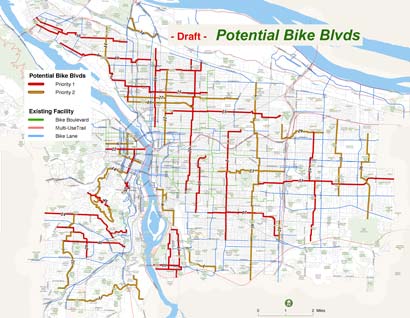
(Click for larger map, or see below for section-by-section views.
NOTE: The map shows planned multi-use trails.)
Next week, Commissioner Adams and his staff will begin a series of Town Hall meetings where you’ll get the chance to review the proposal developed by his “Safe and Sounds Streets” Stakeholder Committee.
“Safe, Sound and Green Streets” is the name of Adams’ Herculean effort to fund traffic safety improvements and address a growing road and bridge maintenance backlog.
One component of the funding package is $24 million for 110 miles of new bicycle boulevards. No, that’s not typo. We’re talking about an initiative (that will likely be on ballots next spring) that would transform our bikeway system in unprecedented ways; creating a network of safe streets throughout the city where bicycles have priority over other vehicles.
This is the not a drill. I repeat. This is not a drill.
Starting Tuesday, citizens will get their first chance to lay eyes on a map of this proposed bike boulevard network.
At this month’s Bicycle Advisory Committee meeting, PDOT bike route mapping expert Jeff Smith gave us a sneak peek at the map and a detailed list of the proposed projects (which you can download below).
PDOT has compiled a list of 42 potential bike boulevards. At this point, not knowing how long it would take to build them if/when the funding measure is approved (Adams says three years, but insiders expect longer), they have separated the projects into “Priority 1” and “Priority 2”.
In an attempt to prime you for the upcoming Town Halls (you are going, aren’t you?) and give you an idea of what the future of Portland’s bike network might look like, I thought I’d share the project list and maps.
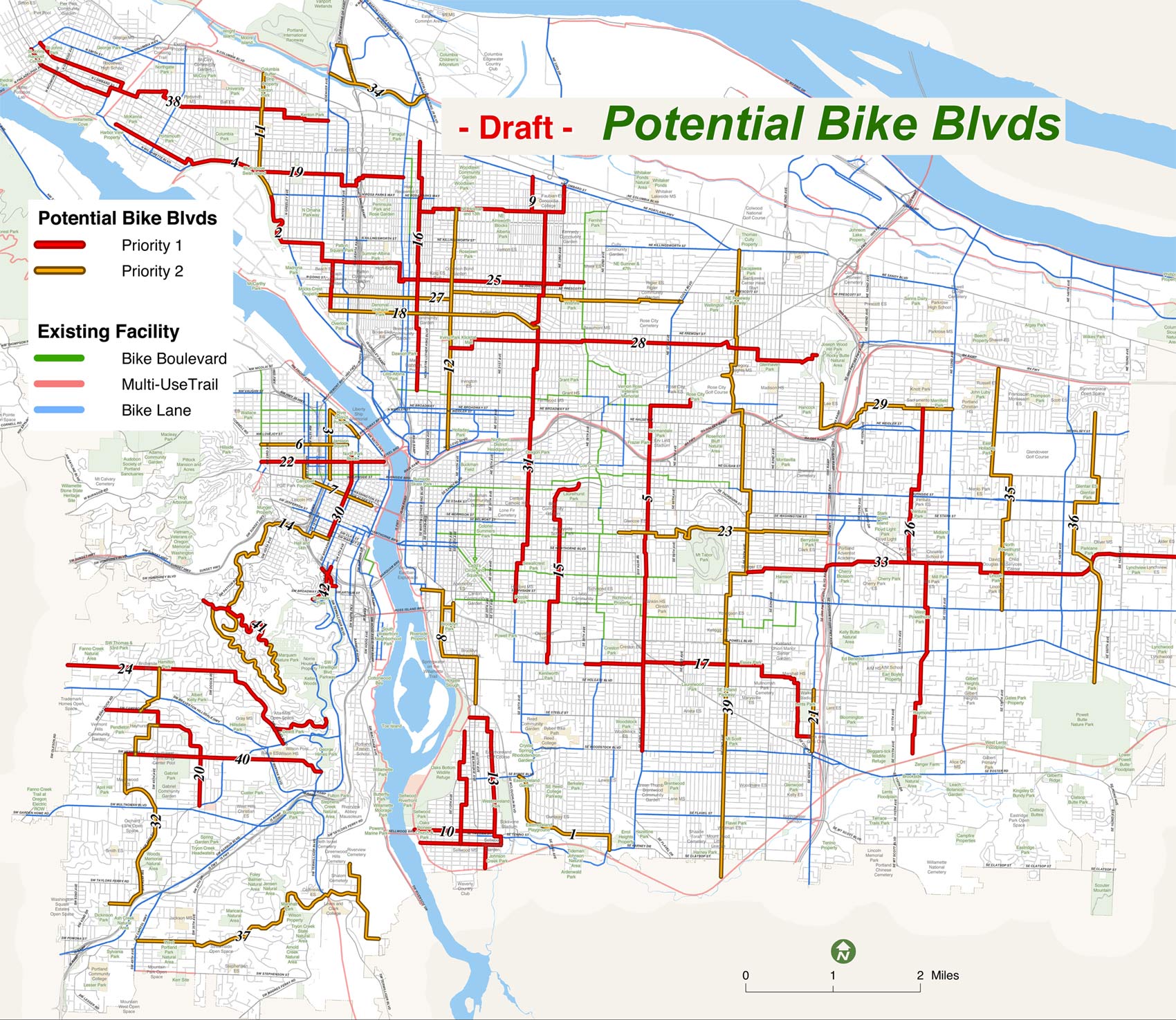
Below is a section-by-section view of the map, followed by the list of proposed projects in the area…
North
Proposed projects (lists separated into Priority 1 and Priority 2):
- #2 – Failing Street Willamette Blvd. Connection, 2 mi.
#16 – Rodney Ave. Bike Blvd., 3 mi.
#19 – Bryant Corridor Blvd., 3.7 mi.
#25 – Going St. Bikeway, 3.2 mi.
#38 – Kenton to St. Johns Blvd. Connection, 4.25 mi.
___
#4 – Willamette Bikeway Improvements, 1 mi.
#11 – Wabash Bike Blvd., 1.1 mi.
#18 – Failing Street Bike Blvd., 3.5 mi.
#27 – Mason-Skidmore Bike Blvd., 4.4 mi.
#34 – N. Portland Trail Completion Project, 1.7 mi.
Notes:
-
The most interesting project on this list is the Willamette Bikeway Improvements. That street is a major route for both cars and bikes. Motor vehicle speeds are notoriously high, but the good news is that it’s wide and I think it’s a perfect candidate for innovation. Perhaps we can get rid of the southbound bike lane and trade it for a contra-flow (bi-directional) separated bike lane (cycle-track) treatment near the northbound sidewalk?
Northwest/Downtown

Proposed projects:
-
#22 – Flanders Street Bike Blvd., 1.3 mi.
#30 – Park Blocks Bike Blvd., 1.3 mi.
#3 – 13th Ave. Universal St., 0.8 mi.
___
#6 – Johnson St. Bike Blvd., 1.0 mi.
#7 – NW Connection to Morrison Bridge, 1.0 mi.
Notes:
- The Flanders Bike Blvd. was promised to us long ago and is supposed to be a binding component of the Burnside-Couch Plan. I’ve heard there is some progress in the Pearl to re-use the Sauvie Island Bridge as the I-405 crossing.
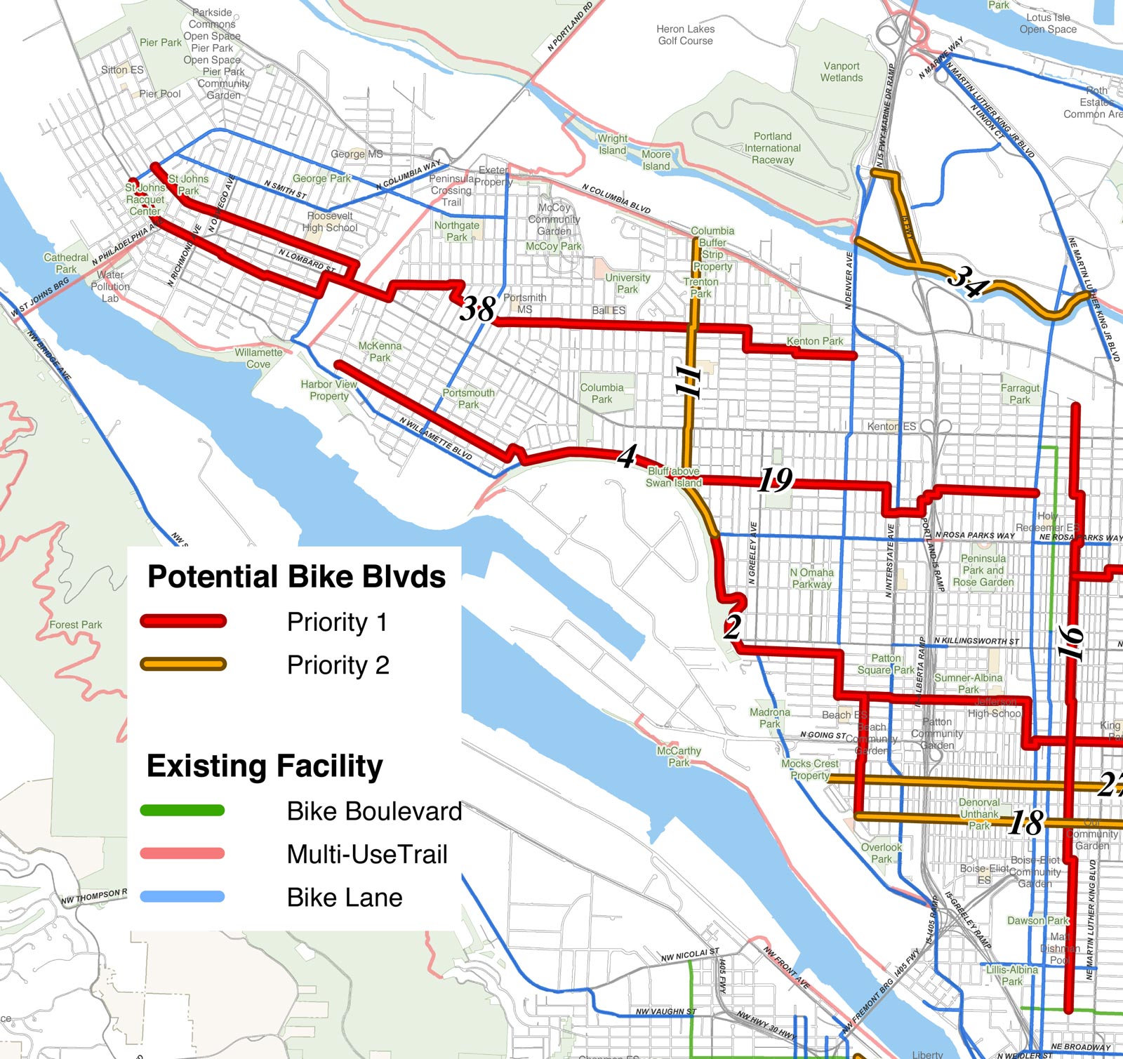
Northeast
Proposed projects:
-
#5 – 50s Bikeway, 4.4 mi.
#9 – Holman St. Bikeway, 2.0 mi.
#25 – Going St. Bikeway, 3.2 mi.
#28 – Kickitat Bikeway, 4.6 mi.
#31 – 20s Bikeway, 5.0 mi.
___
#12 – Ninth Ave. Bikeway, 2.75 mi.
#18 – Failing St. Bike Blvd., 3.5 mi.
#27 – Mason Skidmore Bike Blvd., 4.4 mi.
#29 – Rocky Butte to Gateway Connection, 2.3 mi.
#39 – 70s Bikeway, 7.5 mi.
Southeast
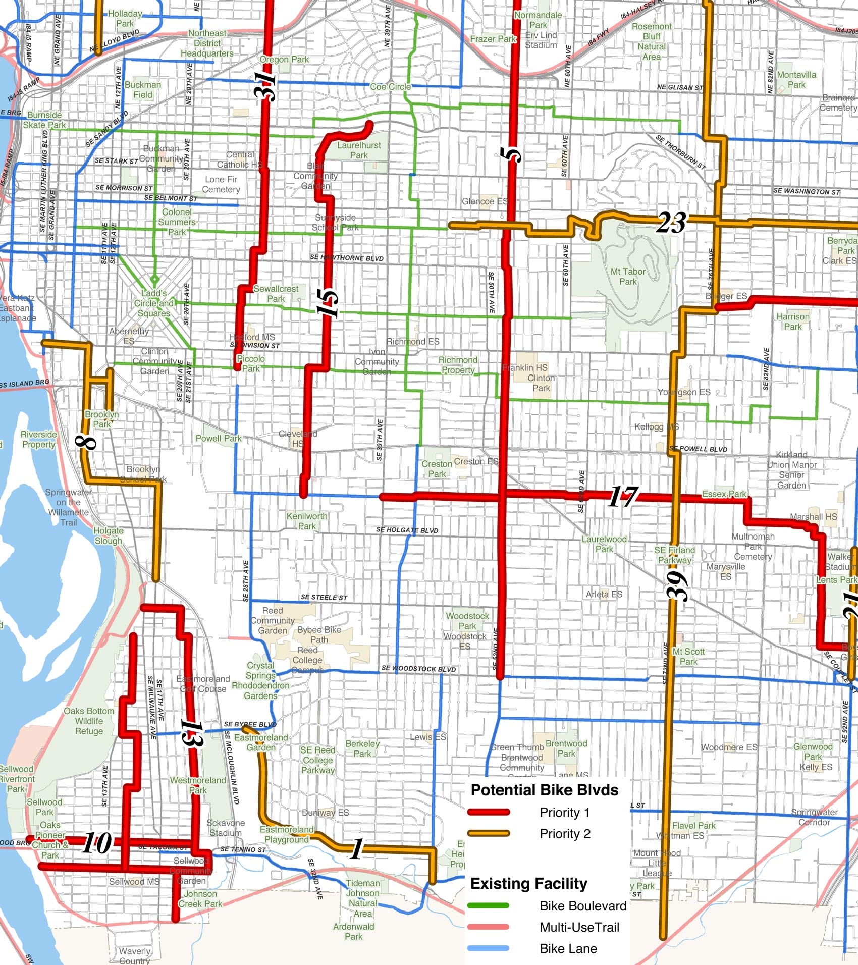
Proposed projects:
-
#5 – 50s Bikeway, 4.4 mi.
#10 – Tacoma Corridor Bike Blvds., 2.0 mi.
#13 – 17th Corridor Bike Blvds., 3.25 mi.
#15 – 30s Bikeway, 2.5 mi.
#17 – Foster Bypass Bike Blvd., 3.3 mi.
#33 – Market Mill Main Bike Blvd., 5.5 mi.
__
#1 – Crystal Springs Bikeway, 1.5 mi.
#8 – Brooklyn to Oaks Park Connection, 1.7 mi.
#21 – Complete 92nd Ave. Bike Lanes, 0.7 mi.
#23 – N of Tabor Bike Blvd., 2.75 mi.
#39 – 70s Bikeway, 7.5 mi.
Notes:
-
It will be interesting to see how the bike boulevard planning effort is integrated with the expansion of MAX into Southeast.
Outer East
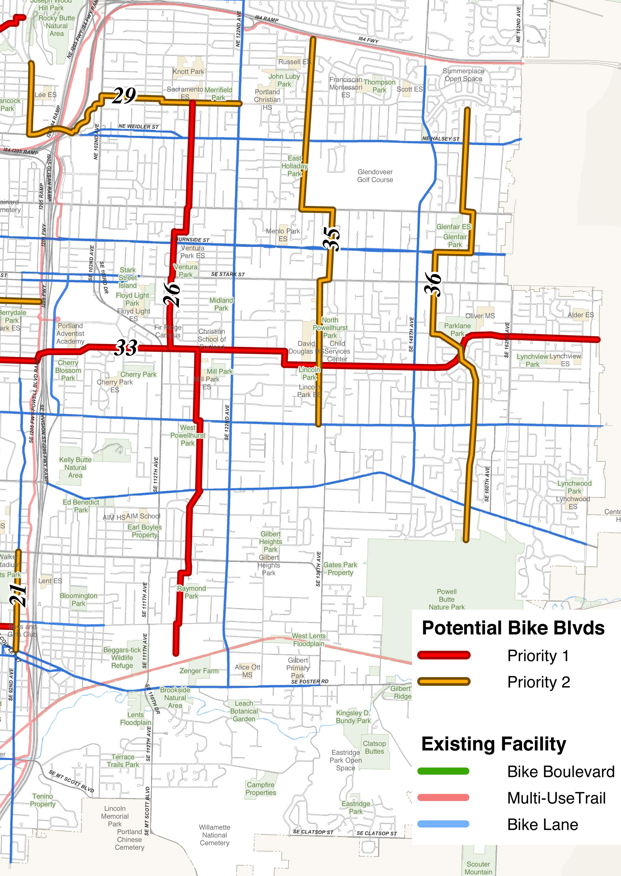
Proposed projects:
-
#26 – One Teens Bike Blvd., 4 mi.
#33 – Market Mill Main Bike Blvd., 5.5 mi.
___
#35 – 130s Bike Blvd., 3.0 mi.
#36 – 150s Bike Blvd., 3.0 mi.
Notes:
-
One Bike Advisory Committee member was concerned at the lack of boulevards proposed for this section. They pointed out that it’s a growing part of town with many schools that are hard to get to. We discussed possibly swapping a project from another part of town to free up more funds for out here.
Southwest
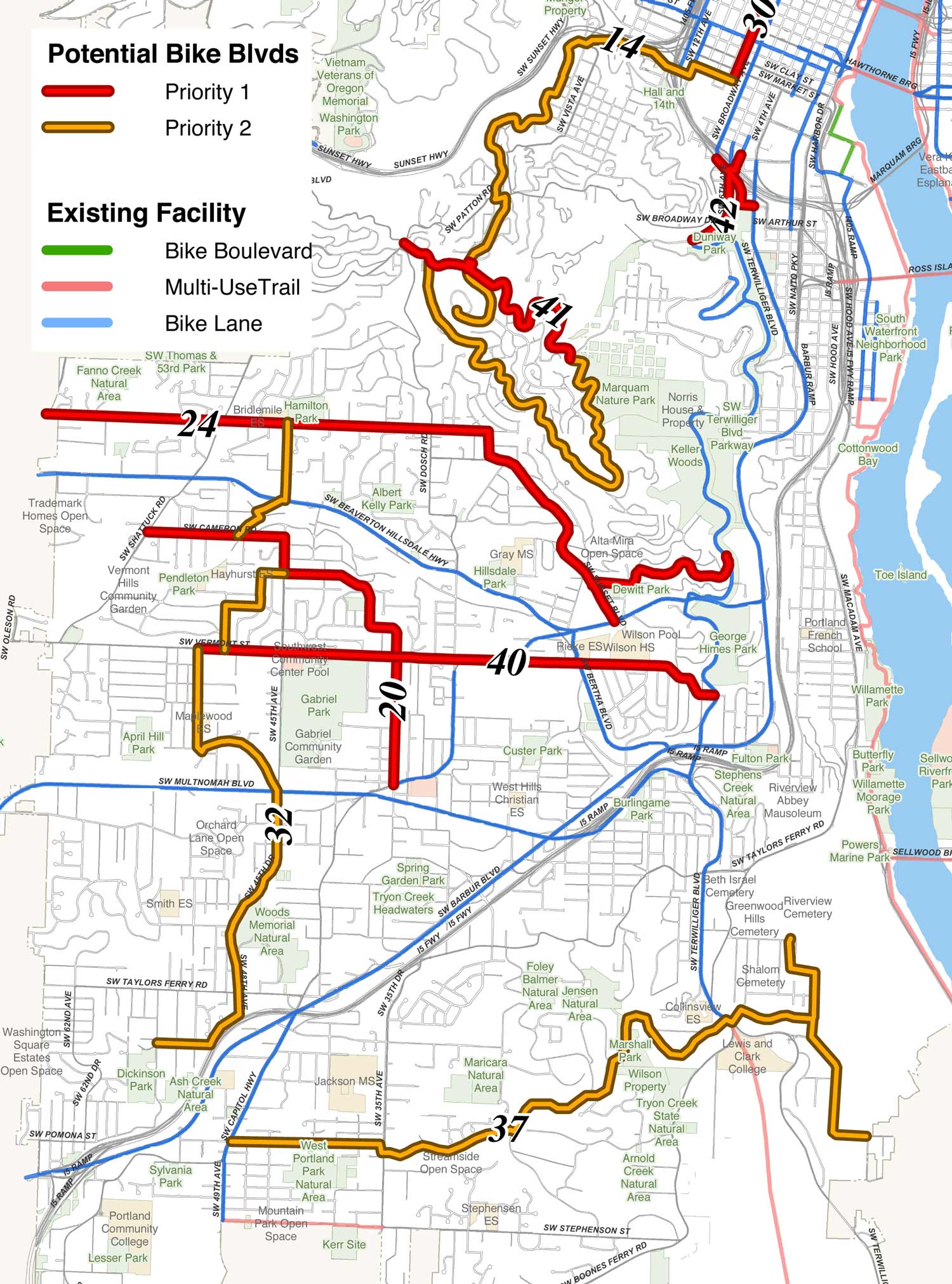
Proposed projects:
#24 – Hamilton Corridor Bikeway, 3.0 mi.
#30 – Park Blocks Bike Blvd., 1.3 mi.
#40 – Vermont, 1.7 mi.
#41 – Fairmont Connection, 1.3 mi.
#42 – Broadway/Barbur/Terwilliger/6th Connection, 0.4 mi.
___
#14 – Downtown to Fairmount Loop, 4.3 mi.
#32 – W of Multnomah Bikeway, 2.7 mi.
#37 – SW Parks Bikeway, 3.8 mi.
Here is the PDF of all the proposed projects that has more details for each one.
So what now?
First, feel free to chime in below with comments. Then, make sure to show up at the upcoming Town Hall Meetings! Tell Sam what you like and/or don’t like about these proposed projects and be ready to share your thoughts with neighbors that may not understand what all the bike boulevard hullabaloo is all about.
Also, stay tuned for more coverage, including how the BTA figures into all this, and an opportunity to help PDOT come up with a new name for “bicycle boulevard”…