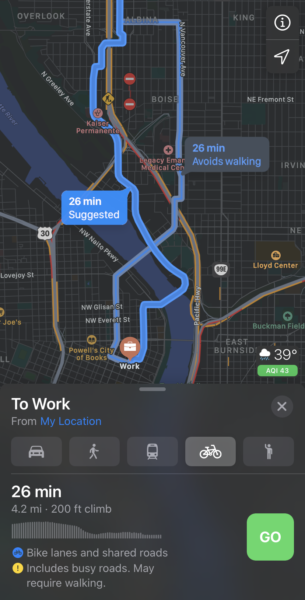
If you use Apple devices and rely on a bicycle to get around Portland, we’ve got some good news. Apple Maps has just expanded its cycling directions feature to our wonderful city.
Detailed cycling directions became available from Apple Maps back in September with the iOS 14 update, but it was limited to only a handful of major cities. Folks who updated their phones in the past few days in Portland were notified of the new feature.
Apple is about 10 years behind Google Maps when it comes to offering bike-specific directions, but an initial look at their offering shows it might have been worth the wait. Apple Maps allows you to avoid hills or busy roads and prioritizes bike lanes and paths. It also gives users a clear idea of elevation gain, the need to walk up/down stairs, and other details.
Advertisement
The interface is very slick. Swipe up on the trip details and you see buttons for “Convenience Stores”, “Coffee” and “Bicycle Shop” locations. There’s also an option to provide turn-by-turn audio guidance. Another cool thing I noticed is little graphic that has air quality index (AQI) rating. The new cycling directions should go perfectly with an Apple Watch because you can just glance at your wrist to see where to go.
While Apple’s map app is beautiful, the directions given will likely take more tweaking to get just right. I tried my old office commute from Peninsula Park to SW 4th Avenue downtown. Apple Maps spit out two options, one on Vancouver Ave and the other on Interstate. It didn’t offer the main route I always took that uses the N Michigan neighborhood greenway. For more details, check this post on 9 to 5 Mac.
If you have an iPhone, give the new cycling directions in Apple Maps a try. For more on how they compare to Google Maps, check the video below:

— Jonathan Maus: (503) 706-8804, @jonathan_maus on Twitter and jonathan@bikeportland.org
— Get our headlines delivered to your inbox.
— Support this independent community media outlet with a one-time contribution or monthly subscription.

