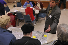
explains the project to
open house attendees.
(Photos © J. Maus)
On Tuesday night at the Hollywood Senior Center, the City of Portland hosted the first official public open house for the Sullivan’s Gulch corridor project. Nearby residents and others simply curious about what could be a major new carfree thoroughfare came to learn more about the project.
As I pulled up I ran into veteran regional trail planner and Metro employee Mel Huie. Mel shared my excitement that the project is finally at this point. “It’s been a long time,” he remarked. When I asked how long, Mel said he first recalled talking about it about 15 years ago.
While I’d love to see projects like this move much more quickly, the fact that the City is now planning this project in earnest is reason for excitement. When I stepped inside, I wasn’t disappointed.
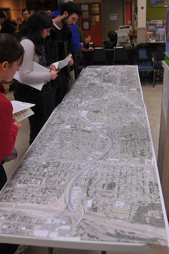
Huge aerial maps were spread on tables and attendees were placing little dots where they’d enter and exit the pathway once it’s built. The manager of PBOT’s Planning Division, project managers from Portland Parks & Recreation (this will be a joint project of both bureaus), consultants hired to help plan the project, and members of the Citizen’s Advisory Committee were on hand to answer questions.
“That means we can build a pathway down the slope and underneath I-205 on ODOT property. It saves us millions and millions of dollars.”
— Paul Smith, PBOT
I didn’t expect to hear any major updates on the project; but I heard one big surprise. You might even consider it a key breakthrough. I also learned much more about how the facility will look and feel (thanks to some new cross-sections which I’ve shared below)
Let’s take a trip from east to west along the future path of the Sullivan’s Gulch Byway (still trying to find a name that’s better than “Trail”)…
On the project’s eastern end, where the I-84 and I-205 meet near Gateway Transit Center, PBOT thought the structural supports of I-205 would be so large that they’d crowd out any space for a trail and leave nothing but unusable Union Pacific Railroad right-of-way. Faced without enough room for a trail, PBOT had engineering firms draw up plans for expensive ramps down from the existing light rail bridge or NE Halsey.
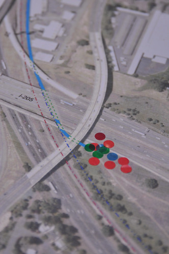
Then, about a month ago, PBOT’s Planning Division Manager Paul Smith (their point man on this project), inspected the area with ODOT. They discovered that ODOT owns a slice of land that will allow PBOT to stay under the bridge (which is what Smith wanted all along) and connect directly from the I-205 path.
“That means we can build a pathway down the slope and underneath I-205 on ODOT property,” Smith explained, “It saves us millions and millions of dollars.”
In a project that’s likely to cost tens of millions to complete, that’s a big deal.
More cost-saving news that I learned last night is that PBOT’s engineering firm (CH2MHill) have determined that the path will be able to go under nearly all the streets and bridges it crosses. This removes the need to make at-grade crossings or expensive path ramps/bridges.
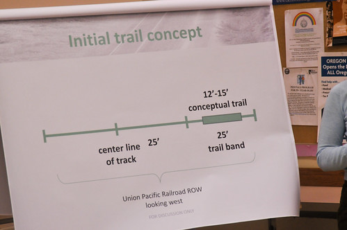
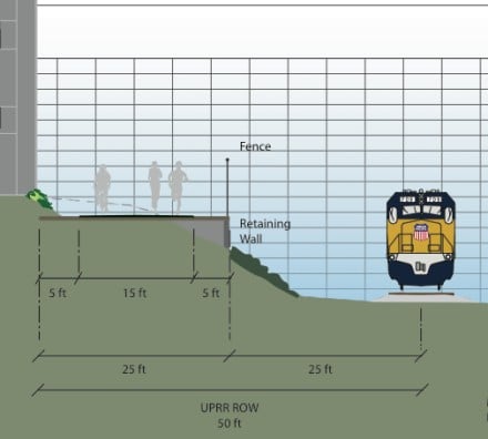
Right-of-way is paramount in this project and UPRR holds nearly all the cards. To conceptualize the space where the pathway will be built, consider that from the center of their track, UPRR owns 50 feet to the north. The future Sullivan’s Gulch path will sit in the outer 25 feet of that “trail band.” See the graphic below as presented last night for a visual:
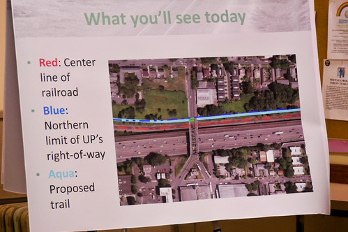
And this image shows it in more realistic terms…
The good news about UPRR is that they are involved in ongoing negotiations with the City of Portland about this project. My hunch is that as the public process gets more attention and as the City makes more progress on the trail, UPRR will soften in their stance and will eventually help make the path happen (by agreeing to sell/give easements through their property).
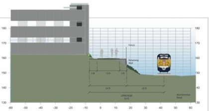
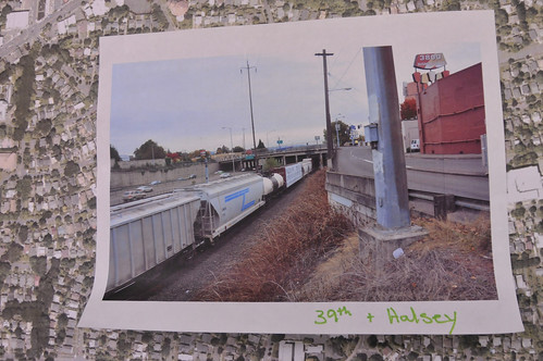
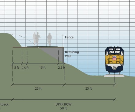
In most of the corridor, the path alignment has no other option than the UPRR right-of-way. And in some sections, due to the presence of existing buildings or other infrastructure, it gets very tight. PBOT says the tightest spot in the entire alignment is near NE Halsey and 39th (below). In this section, they’ll have to work with just 17 total feet of potential trail right-of-way…
Continuing west from I-205, the path will likely cross at-grade with NE 82nd Avenue with a new traffic signal. The next section, from 82nd to 70th, could be one of the first to be built. As we’ve aready reported, the City has applied for a $700,000 federal grant to design and build this 12 block section using NE Jonesmore Street (see potential cross section drawing below).
As Smith took me along the corridor map, he explained that they have to keep two main things in mind while planning the alignment. First, the path should be as direct as possible for bike traffic and second, it needs to have connections from and to adjacent neighborhoods and commercial districts.
Fitting a new pathway within this limited right-of-way (19 buildings come right up against the “trail band”) and weaving around the sensitive negotiations with UPRR and Providence Hospital (another large landowner in the area) will require careful negotiations and engineering; but it’s a challenge PBOT seems to be willing to take on.
The entire pathway won’t be complete for years to come, but several pieces could come sooner. The 12 block section west of 82nd could very well be funded and built, and the inner portion west of NE 21st (which is all City property) could also see see action before other segments.
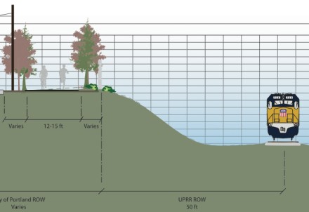
As for how the actual pathway will look; the path itself will be about 15-feet wide (the path on the Hawthorne Bridge, by comparison, is 10-11 feet wide), with five feet of additional elbow room on each side (that also happens to be the width of Roman roads, Smith told me, “Wide enough for two chariots to pass side-by-side”).
Another thing to keep in mind is that in nearly all sections, the path will be significantly higher (vertically) than the rail line. Below are more cross section drawings to give you a better idea…
(Image: Alta Planning + Design)
(Image: Alta Planning + Design)
Another x-factor is how UPRR’s attitude on the project shifts. If they become more willing to share their land, it could change the timeline considerably. As for how much it will cost, the City is working on a detailed estimate they expect to have before the end of the year.
For more information on the project, visit the City’s website.