
Click to enlarge
(Graphic: Joe Broach).
It’s been just about one month since we launched the Bike Safety and Monitoring Reporting Tool, a.k.a. B-SMaRT. The Google Maps-based tool is a new way to capture data from the community about close calls, collisions, and problem locations.

I asked the brains behind the project, B-SMaRT’s developer Joe Broach, for an update and he shared some interesting information.
So far, 146 users have registered (registration is required in order to create an entry) and 79 of them have opted in to be notified (via email) if/when public input is needed on projects around their incident.
In the past month, there have been 109 reports filed in the Portland Metro area. Here’s the breakdown:
- 15 collisions: Of those collisions, 3 were non-injury and 12 involved an injury. Only 2 of the 15 collisions were reported to the DMV (which gives you an idea of how much bicycle data is lacking in official DMV stats).
- 47 close calls.
- 47 problem locations (4 were poor conditions, 15 had poor behavior, 28 had poor design)
The most common incident type for close calls/collisions is the “right hook” (32%), followed by the “left cross” (15%), and then both parties traveling same direction (14%; could be passing too closely, merged into, etc.).

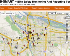
Joe also ran a report of all incidents and created a “Hotspots” map (shown above, download larger version here). Not too surprisingly, reports are most concentrated at the following locations:
- Along Broadway starting east of the bridge and continuing into downtown
- Along the west approach via Madison to the Hawthorne Bridge
There are also noticeable concentrations around:
- The east side of Ladd’s
- N Interstate and Greeley
- The Scholl’s Ferry/Skyline overpass at Hwy 26
In future updates, Joe plans to add the Google Street View feature for reporting problem locations.
Joe also told me that he’s been contacted by about a dozen advocates and officials in other cities that want to use the tool. Currently, it’s possible to add incidents from any location in the world, but in the interest of keeping the data clean and separated, we might restrict the BikePortland version of B-SMaRT to just this region.
Joe and I are very excited about how this tool is developing and it will only improve and reveal better information as more data is submitted. Be sure to tell your friends about it and stay tuned for more developments.
Also, Joe and I have put this tool together without any outside funding or grants. If you think this and other features of BikePortland.org are valuable, please consider leaving us a tip via PayPal. The button is below. Thanks.