
(ZGF Architects)
The flyover lives.
New renderings and details for the Green Loop through the Broadway Corridor project site have been made available by architects working on the project. They include our most detailed view yet of how the path will navigate from the Parks Blocks, through the site, and up to the 30-foot high junction at NW Lovejoy and the Broadway Bridge.

After a general planning concept was adopted earlier this month, ZGF Architects has just submitted drawings for the site to the City Auditor’s Office in advance of a Design Commissioner meeting set for June 6th. ZGF has been working on the site plan with Portland’s development agency, Prosper Portland, since 2015.
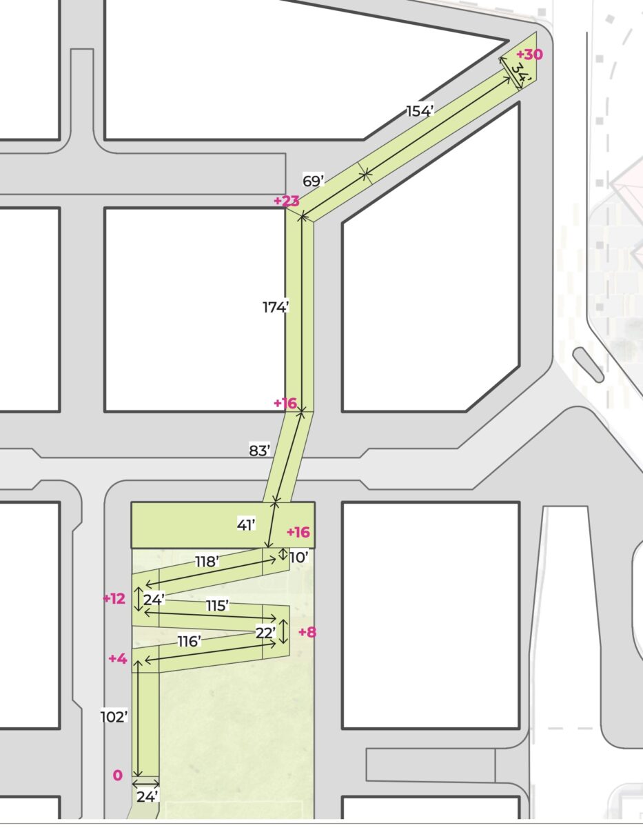
The Green Loop — a project to create a carfree pathway around the central city — figures into this project because the alignment of the path goes right through it. The drawings released today offer us brand new details about how the Green Loop will be designed through the Broadway Corridor site — including an 83-foot long bridge that would go over NW Johnson Street.
Here’s a description from ZGF:
“The Green Loop will approach the USPS site from the south along the North Park Blocks, gradually climbing at the north end of the central open space to a bridge crossing of Johnson Street. North of Johnson, the Green Loop continues as an elevated bridge to the intersection of the Lovejoy and Broadway Bridge ramps. The ramp will be integrated with landscape and an active retail facility, providing a significant placemaking opportunity.”
The drawing below shows elevation (in pink) and dimensions (in black):

The green-and-pink striped lines are “bicycle and pedestrian access ways” which will help people access the Green Loop from surface streets:

Advertisement

ZGF shared these images as examples of the design of the path and adjacent landscape:

In the “Bicycle Circulation” drawing below, note the NW Johnson neighborhood greenway and how the Green Loop connects directly to North Park Blocks:

The sketch below shows a view looking north at the future site. Note how the ramp would take you from NW 9th, through the site and onto the bridge:

Here’s what ZGF added to give context to the drawing above:
“The preferred concept brings the existing two-way Park Avenue north from Hoyt Street to Johnson Street, helping to connect the North Park Blocks to the Johnson Street Neighborhood Greenway… The street will have active ground floors of buildings at its western edge, with a pedestrian focused woonerf street serving one lane in each direction. At the east edge of the street, the Green Loop will transition from Park Avenue to the Park Block, where it will climb north and up over Johnson Street on a landscaped switchback ramp. The adjacent park block is intended to be open and flexible, to accommodate a wide range of programmed and informal community gathering and recreation.”
Prosper Portland expects the first phase of development for this site (which will be housing, with retail in phase two) to begin in 2021. The Portland Bureau of Transportation is currently doing a transportation impact study on the site which we hope to share once it’s ready.
To download the full ZGF presentation, click here.
— Jonathan Maus: (503) 706-8804, @jonathan_maus on Twitter and jonathan@bikeportland.org
Never miss a story. Sign-up for the daily BP Headlines email.
BikePortland needs your support.