(Photos © J. Maus/BikePortland)
With two weeks to go for a set of major construction-related detours in Southeast Portland, they’re continuing to be a major hassle for all road users. We went out to survey the situation yesterday and we’re curious how you’re coping.
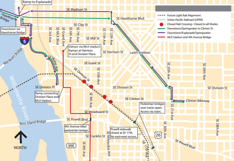
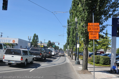
It’s all caused by TriMet construction work on the Portland-Milwaukie light rail line, which in 2015 will open light rail stations near OMSI, Southeast 12th and Clinton, Southeast 17th and Rhine, Southeast 17th and Holgate, and several points along McLoughlin Boulevard into central Milwaukie. But for the moment, as reader Ian Stude put it in a recent comment here on BikePortland, the Brooklyn neighborhood is a “desert island,” cut off from the rest of Southeast Portland by the simultaneous closures of the Union Pacific railroad crossings at 8th, 9th, 11th, 12th, and 17th Avenues (PDF of closures map).
On its detours page, TriMet promises these detours will end by 5 a.m. on Monday, Aug. 5. (The exception is the Powell pedestrian underpass at 17th Avenue, which will remain closed until a rebuilt version of the intersection opens this fall.) Until then, there are only a few ways to get around.
After we posted something about the detours on Twitter yesterday, several followers were eager to share their views:
@BikePortland Tried to get from OMSI to Clinton Theater on Division: was a MESS! To avoid Powell, had to backtrack to Clay. 1st World Probs.
— Together Gear (@TogetherGear) July 23, 2013
@BikePortland Was just there. Very confusing! Rode sidewalk down Powell to SE 13th PL & crossed RR tracks to SE 14th.
— Builder By Bike (@BuilderByBike) July 23, 2013
@BikePortland I could tell you STORIES. that intersection is terrible and the flaggers try to send families down Powell or over ped bridges
— Fiets of Parenthood (@parent_fiets) July 22, 2013
@BikePortland I got so lost trying to get from Springwater to Richmond on Sat. Should have gone to Hawthorne b/c Division Pl was a dead-end
— Abby Bush (@abbyknitter) July 22, 2013
@BikePortland I have been trying to avoid that area on my commute. I have been stuck going east on Powell to get to Clinton, which I hate.
— Brian Middleton (@aapljack) July 22, 2013
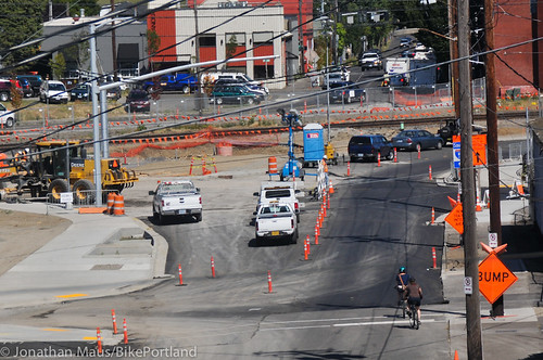
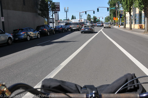
Leaving from our downtown office yesterday, Jonathan rode south past OMSI and ended up south of Division. When he asked one of the flaggers how to get north, he was directed onto a sidewalk to another flagger a few blocks away at SE Woodward and Milwaukie. That flagger said his only two options were to ride north on 99E (SE Grand Ave) or go all the way to wind his way to SE 21st (about a 1/2 mile away as the crow flies).
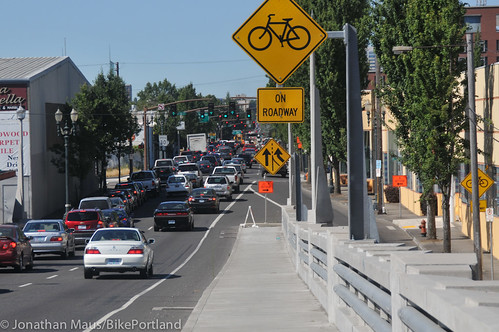
He opted for 99E. The signage wasn’t that great and once in the bike lane/shoulder, he found it to be full of gravel and other debris, not to mention that 99E is a very busy arterial and there is not special signage that warns road users that more people on bikes that usual will be on it (until the very end of the viaduct where there’s a permanent “Bicycles on Roadway” sign).
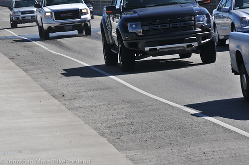
The next orange detour sign he saw was up on the sidewalk and directed him down the viaduct ramp to SE Division Place. Continuing north on 99E, the bike lane abruptly ends. Some detour signs direct users to make a dangerous right turn with poor visibility. Other detour signs direct people into the ride lane of 99E which has no dedicated bicycling space and streetcar tracks running parallel.

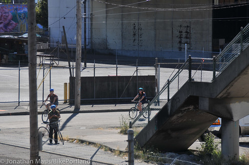
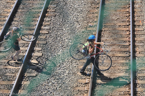
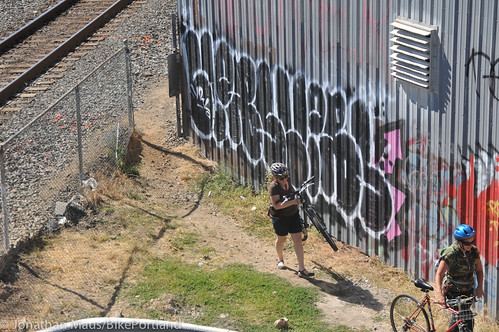
Many people on bikes are using the SE Brooklyn Street footbridge over the railroad tracks at SE 16th Ave. When Jonathan observed that area yesterday he came upon a group of four women on bikes who looked confused. Instead of carrying their bikes up and then down the bridge stairs, they snuck through a hole in the fence and carried their bikes across the active railroad tracks.
“You can do it,” one of them said, “But it’s a bit dodgy.”
Things are a bit better for the Sellwood-Moreland area and further south, which can at least access the Esplanade and eastside industrial district using the Springwater Trail along the Willamette River. Other than remaining along the river, though, the safest ways to cross the railroad in inner Southeast Portland seem to be:
- Riding on the sidewalk over the MLK viaduct, then using a ramp to access SE Division Street.
- Carrying your bike over the three-story pedestrian bridges at SE 16th and Brooklyn or SE Lafayette and 20th.
- Riding on the sidewalk over the Holgate Street bridge.
“I would hate to live in the Brooklyn neighborhood for the next few weeks. They are going to be on a desert island thanks to the Portland-Milwaukie Light Rail simultaneous closures of 8th, 9th, 11th, 12th, and 17th crossings of the freight rail tracks. Ouch!”
— reader Ian Stude
None of these is convenient, obviously.
“This is difficult to impossible with cargo bikes, or even with ordinary bikes for many women and children,” writes reader and Brooklyn resident Daniel Wright. “I took my grade schooler to New Seasons using this bridge and ended up having to carry his bike for him. I’m not sure I’d even attempt it with our Madsen cargo bike. Even on the MLK viaduct and Holgate, the street is far too dangerous for most cyclists, so you must use the sidewalk. The situation is pretty bad for drivers too, but at least they have the option of using Powell Boulevard to go under the tracks, something cyclists and pedestrians can’t do because the sidewalk has been closed there for a long time due to TriMet construction, no formal bike lane exists and drivers frequently go 50-55 mph.”
As The Oregonian reported last week, this major blockage is actually by design: TriMet and Union Pacific Railroad were worried that if each blockage happened at different times, desperate drivers might block trains as they tried to get through the remaining intersections.
“We didn’t want detours via the at-grade rail crossings because of concerns with queuing vehicles across UP tracks,” TriMet spokeswoman Mary Fetsch told the newspaper. “So the detours are designed across grade-separated crossings of the UP tracks.”
For the next two weeks, people crossing the tracks by bike and foot are suffering collateral damage.
Fortunately, TriMet says it’s keeping some people on site 24 hours a day to minimize the duration of the closure.
The great promise of this new MAX line is that, unlike the Green or Blue lines that were built along highways, it runs straight through an urban area that’s ripe for dense, human-friendly development. But for now, that’s making the construction extra annoying.
Allowing for safe and easy-to-follow detours during construction projects is an ongoing issue for the City of Portland. One way they’ll improve is by hearing your feedback. Please consider sharing your tips and experiences in the comments and if you come across unsafe situations, don’t hesitate to report it to 823-SAFE.