“ODOT used the Oregon Bicycle and Pedestrian Plan (1995) when designing this project, which does not… mention buffered bike lanes or cycle track and design criteria.”
— ODOT
It’s a shame that outdated engineering guidelines continue to prevent us from designing streets in a way that matches our goals — but that’s exactly what’s happening out on a segment of Sandy Blvd in east Portland.
Last month, we shared the news that the Oregon Department of Transportation (ODOT) is spending $3.6 million to rebuild a one-mile segment of Sandy between NE 122nd and 141st Avenues. The US 30 Bypass (Sandy Blvd) Safety Project comes with standard, six-foot bike lanes. That might sound good, but this type of bike lane is nothing but a continuation of a status quo that is inadequate for bicycle riders and that doesn’t match up our our city and statewide transportation planning goals.
A standard bike lane next to heavy auto and truck traffic going 35-40 mph is the same way we’ve designed roads since the 1990s. Today, planners and the public are insistent on more significant bikeway access that includes some level of separation.
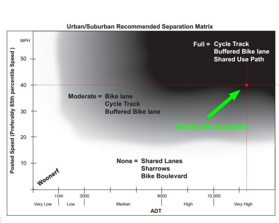
After publishing that story, I heard from local bicycle transportation planner and activist Nick Falbo. After he learned about the project, Falbo contacted ODOT to point out that their own Bicycle and Pedestrian Design Guide (published in 2011) shows that the appropriate bicycle facility for a roadway with the characteristics of Sandy is either a cycle track, a buffered bike lane, or a shared use path (all of which offer much higher quality bicycle access than a conventional bike lane).
To back up his claim, Falbo attached the “Recommended Separation Matrix” chart from ODOT’s guide book. As you can see below, with its 40 mph speed and about 20,000 average daily traffic volume (ADT), this segment of Sandy falls well within a recommended range for separated bicycle infrastructure:
“Can you provide more information as to why bicycle lanes were preferred for the final design over a more separated facility as indicated by ODOT’s own design guides?” asked Falbo.
Falbo heard back from ODOT one day later. Unfortunately they said the design of the project was finalized in late 2010, before the 2011 ODOT Bicycle and Pedestrian Design Guide was published and its “separation matrix” were in use. To design the Sandy project, ODOT planners used the Oregon Bicycle and Pedestrian Plan that was last updated in 1995 — a full 15 years before the project was designed.
Must we really rely on outdated guide books to design our roads? If engineers and planners at ODOT know better, why can’t they make an exception during the late stages of a project’s design? This is unfortunate and frustrating and I hope we can avoid this type of mistake in the future.


